Lost-in-Forest GPS-Denied Positioning System
O'Shea; Patrick ; et al.
U.S. patent application number 16/291351 was filed with the patent office on 2019-12-05 for lost-in-forest gps-denied positioning system. The applicant listed for this patent is The Charles Stark Draper Laboratory, Inc.. Invention is credited to Juha-Pekka J. Laine, Charles A. McPherson, Patrick O'Shea, William W. Whitacre, Christopher C. Yu.
| Application Number | 20190368877 16/291351 |
| Document ID | / |
| Family ID | 67003589 |
| Filed Date | 2019-12-05 |

View All Diagrams
| United States Patent Application | 20190368877 |
| Kind Code | A1 |
| O'Shea; Patrick ; et al. | December 5, 2019 |
Lost-in-Forest GPS-Denied Positioning System
Abstract
Local terrain feature location data is obtained from a local sensor device at a user location without a prior-known global position. The local terrain feature location data characterizes relative distances and directions to a plurality of local terrain features nearest to the user location. Global terrain feature location data stored in at least one hardware memory device is accessed. The global terrain feature location data characterizes relative distances and directions between a plurality of distinctive terrain features located in a defined terrain region in terms of absolute global location coordinates. The local terrain feature location data is compared to the global terrain feature location data to develop multiple pattern matching hypotheses, wherein each pattern matching hypothesis characterizes a likelihood of a subset of the local terrain features matching a subset the global terrain features. Global location coordinates for the user location is then determined from the pattern matching hypotheses.
| Inventors: | O'Shea; Patrick; (Munster, IN) ; Whitacre; William W.; (Boston, MA) ; Yu; Christopher C.; (Belmont, MA) ; Laine; Juha-Pekka J.; (Boston, MA) ; McPherson; Charles A.; (North Reading, MA) | ||||||||||
| Applicant: |
|
||||||||||
|---|---|---|---|---|---|---|---|---|---|---|---|
| Family ID: | 67003589 | ||||||||||
| Appl. No.: | 16/291351 | ||||||||||
| Filed: | March 4, 2019 |
Related U.S. Patent Documents
| Application Number | Filing Date | Patent Number | ||
|---|---|---|---|---|
| 62678764 | May 31, 2018 | |||
| Current U.S. Class: | 1/1 |
| Current CPC Class: | G01C 21/005 20130101; G01C 21/16 20130101; G01S 13/89 20130101; G01S 7/4808 20130101; G01C 21/04 20130101; G01S 17/89 20130101; G06K 9/00664 20130101; G01S 5/16 20130101 |
| International Class: | G01C 21/04 20060101 G01C021/04; G01C 21/16 20060101 G01C021/16; G01S 13/89 20060101 G01S013/89; G01S 17/89 20060101 G01S017/89; G06K 9/00 20060101 G06K009/00 |
Claims
1. A computer-implemented method employing at least one hardware implemented navigation processor for terrain feature matching navigation, the method comprising: operating the navigation processor to execute program instructions to: obtain local terrain feature location data from a local sensor device at a user location without a prior-known global position, the local terrain feature location data characterizing relative distances and directions to a plurality of local terrain features nearest to the user location; access global terrain feature location data stored in at least one hardware memory device, wherein the global terrain feature location data characterizes relative distances and directions between a plurality of distinctive terrain features located in a defined terrain region in terms of absolute global location coordinates; compare the local terrain feature location data to the global terrain feature location data to develop a plurality of pattern matching hypotheses, wherein each pattern matching hypothesis characterizes a likelihood of a subset of the local terrain features matching a subset the global terrain features; and determine global location coordinates for the user location from the plurality of pattern matching hypotheses.
2. The method according to claim 1, further comprising: updating the global location coordinates for the user location as the user location varies over time with user movement.
3. The method according to claim 2, wherein the updating includes using time varying location movement data from an inertial measurement unit (IMU) device.
4. The method according to claim 1, wherein the comparing is based on a k-closest vector search algorithm.
5. The method according to claim 1, wherein the comparing includes considering mapping uncertainty factors in terms of a defined pattern matching confidence threshold.
6. The method according to claim 1, wherein the local sensor device is a LiDar device.
7. The method according to claim 1, wherein the local sensor device is a laser range finding device.
8. The method according to claim 1, wherein the local sensor device is a camera.
9. The method according to claim 1, wherein the global terrain feature location data is derived from overhead imaging data.
10. The method according to claim 1, wherein the global terrain feature location data is derived from lidar data and/or radar data.
11. The method according to claim 1, wherein the distinctive terrain features comprise trees.
12. A computer program product encoded in a non-transitory computer-readable medium, which when executed by a computer causes the computer to perform the following operations: obtain local terrain feature location data from a local sensor device at a user location without a prior-known global position, the local terrain feature location data characterizing relative distances and directions to a plurality of local terrain features nearest to the user location; access global terrain feature location data stored in at least one hardware memory device, wherein the global terrain feature location data characterizes relative distances and directions between a plurality of distinctive terrain features located in a defined terrain region in terms of absolute global location coordinates; compare the local terrain feature location data to the global terrain feature location data to develop a plurality of pattern matching hypotheses, wherein each pattern matching hypothesis characterizes a likelihood of a subset of the local terrain features matching a subset the global terrain features; and determine global location coordinates for the user location from the plurality of pattern matching hypotheses.
13. The product according to claim 12, wherein the operations further comprise: updating the global location coordinates for the user location as the user location varies over time with user movement.
14. The product according to claim 13, wherein the updating includes using time varying location movement data from an inertial measurement unit (IMU) device.
15. The product according to claim 12, wherein the comparing is based on a k-closest vector search algorithm.
16. The product according to claim 12, wherein the comparing includes considering mapping uncertainty factors in terms of a defined pattern matching confidence threshold.
17. The product according to claim 12, wherein the local sensor device is a LiDar device.
18. The product according to claim 12, wherein the local sensor device is a laser range finding device.
19. The product according to claim 12, wherein the local sensor device is a camera.
20. The product according to claim 12, wherein the global terrain feature location data is derived from overhead imaging data.
21. The product according to claim 12, wherein the global terrain feature location data is derived from lidar data and/or radar data.
22. The product according to claim 12, wherein the distinctive terrain features comprise trees.
Description
[0001] This application claims priority from U.S. Provisional Patent Application 62/678,764, filed May 31, 2018, which is incorporated herein by reference in its entirety.
TECHNICAL FIELD
[0002] The present invention relates to GPS-denied navigation and, more particularly, to navigation systems that use previously obtained landmark information, such as imagery of treetops, and a multiple hypothesis k-closest matching algorithm to automatically ascertain a location.
BACKGROUND ART
[0003] Navigation is necessary for human economic and social activity. Navigation can also be essential in situations or environments in which safety of the navigator is not secured. The challenge in navigating accurately to a destination or direction is compounded with navigation instruments that have errors and/or in areas without connection to a satellite when attempting to use a global positioning system (GPS). For example, a soldier or sailor may depend on navigation systems and techniques to get to safety and may be unable to do so in GPS-denied areas.
[0004] Terrain-aided navigation and landmark-based navigation typically require prior knowledge for mapping and positioning to be useful. Vision-aided navigation requires more complex data-processing requirements and introduces a much more difficult component in trying to image match an image taken from a horizontal perspective to an image taken from a vertical perspective. Because of this challenge, current vision-aided navigation research mainly focuses on local navigation and mapping rather than global geolocation. When using existing landmark positions and range finding equipment to geolocate and navigate, both general prior position knowledge and a clear view of landmarks in the area are needed, which may not be possible in a lost-in-a-forest setting.
SUMMARY
[0005] Embodiments of the present invention are directed to a computer-implemented method employing at least one hardware implemented navigation processor and a related computer program product for terrain feature matching navigation. The navigation processor is operated to execute program instructions to obtain local terrain feature location data from a local sensor device at a user location without a prior-known global position, the local terrain feature location data characterizing relative distances and directions to a plurality of local terrain features nearest to the user location. Global terrain feature location data stored in at least one hardware memory device is accessed, wherein the global terrain feature location data characterizes relative distances and directions between a plurality of distinctive terrain features located in a defined terrain region in terms of absolute global location coordinates. The local terrain feature location data is compared to the global terrain feature location data to develop multiple pattern matching hypotheses, wherein each pattern matching hypothesis characterizes a likelihood of a subset of the local terrain features matching a subset the global terrain features. Global location coordinates for the user location are determined from the pattern matching hypotheses.
[0006] In further specific embodiments, the global location coordinates for the user location are updated as the user location varies over time with user movement; for example, using time varying location movement data from an inertial measurement unit (IMU) device. The comparing may be based on a k-closest vector search algorithm and/or may include considering mapping uncertainty factors in terms of a defined pattern matching confidence threshold.
[0007] The local sensor device may specifically be a LiDar device, a laser range finding device or a camera. The global terrain feature location data may be derived from overhead imaging data, lidar data and/or radar data. And the distinctive terrain features may be trees.
BRIEF DESCRIPTION OF THE DRAWINGS
[0008] FIG. 1 shows a functional block diagram of a broad embodiment of the present invention.
[0009] FIG. 2 shows various steps in determining a user global location according to an embodiment of the present invention.
[0010] FIG. 3 shows an example of obtaining local terrain feature location data from a local sensor device according to an embodiment of the present invention.
[0011] FIG. 4 shows an example of an overhead image of a portion of a forest illustrating the pattern of crown delineation.
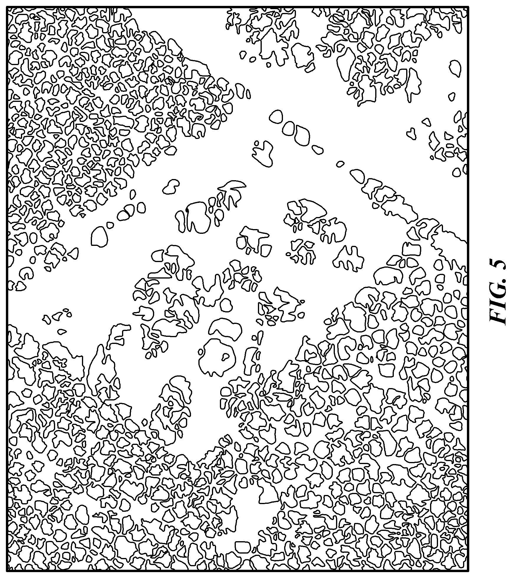
[0012] FIG. 5 shows the process flow in one specific embodiment of a multiple hypothesis k-closest matching algorithm.
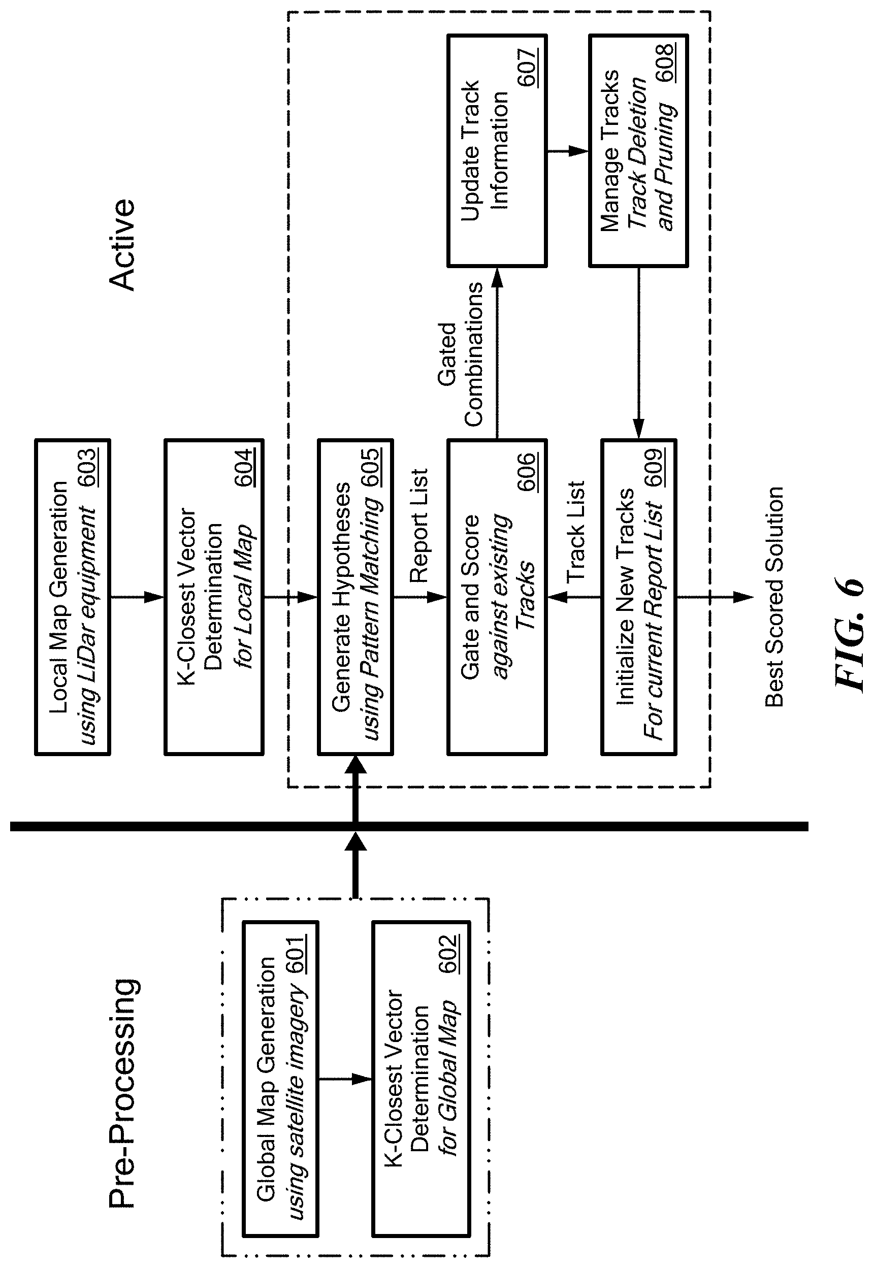
[0013] FIG. 6 shows the general process flow in one specific embodiment of a multiple hypothesis k-closest matching navigation approach.
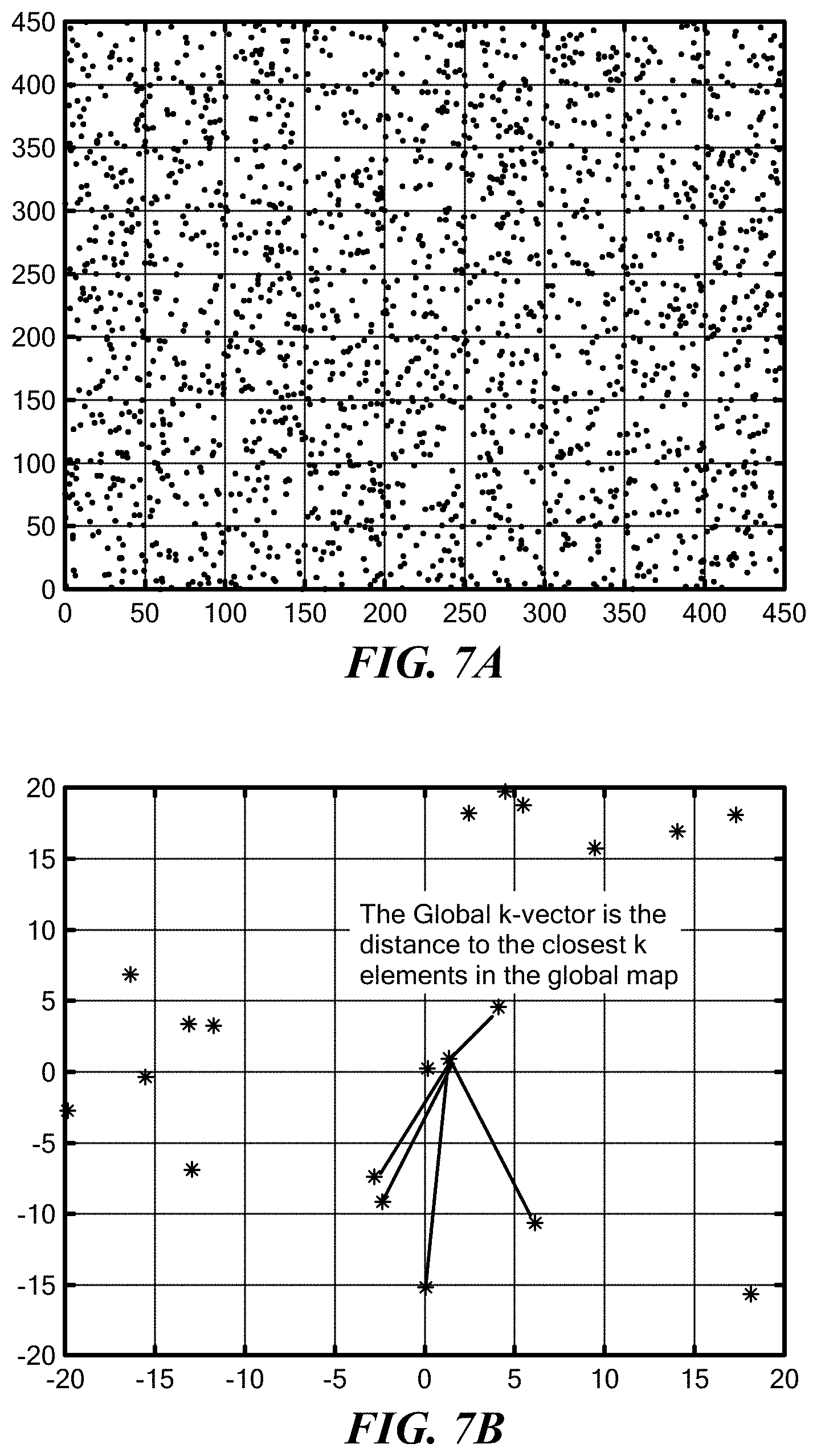
[0014] FIG. 7A shows a two-dimensional map of a section of forest where each individual tree location is represented as a dot.
[0015] FIG. 7B shows that for each tree object in FIG. 7A, the distance to the k-closest elements is computed to form a k-vector that describes the object location.
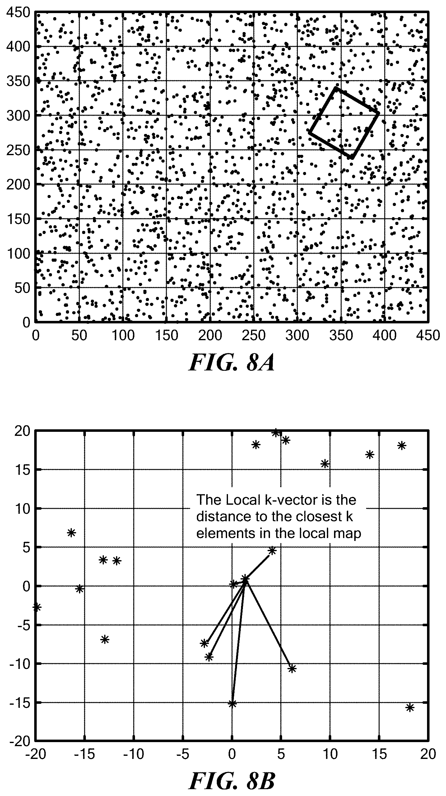
[0016] FIG. 8A shows highlighting a local area in a two-dimensional map of a section of forest as in FIG. 7A.
[0017] FIG. 8B shows that for each tree object in the local area in FIG. 8A, the distance to the k-closest elements is computed to form a k-vector that describes the object location.
[0018] FIG. 9A shows using a fit line for the first element of the feature vector for the k-vector search algorithm.
[0019] FIG. 9B shows that a small portion of the feature vectors can be compared.
[0020] FIG. 10A shows using the predetermined fit line to refine the search.
[0021] FIG. 10B shows that the rest of the feature vector can be used to further reduce the number of possible local-to-global tree matches.
[0022] FIG. 11 shows a pass list consisting of all pairings that pass the threshold.
DETAILED DESCRIPTION
[0023] Embodiments of the present invention are directed to approaches for precision GPS-denied positioning and navigation with little additional equipment and limited data processing requirements. The specific context discussed herein is a user who is lost in a forest without prior position information, though the ideas have applications in other settings that have multiple terrain features. For example, in urban environments, buildings, statues and/or other structures may serve as the "trees" referenced herein. Even greatly damaged buildings (for example, damaged as a result of an earthquake or war) may still have some standing walls, corners and edges that may be used so long as a distance and angle to such terrain features can be measured from a user's position. Measurements of distance may be inferred from sequences of angle measurements through user motion as typical in visual odometry or structure from motion (SFM) applications.
[0024] Embodiments of the present invention such as those described herein require little existing infrastructure and can be accomplished with minimal resources. There is also no requirement to have prior information of the observer location. The general concept revolves around the identification of distinctive terrain features such as trees in an observer's local area that can be matched to existing maps of global tree locations using a robust adaptation of star identification algorithms. The resulting matches provide the user with an accurate global position based on the existing map. This method can then be extended to incorporate inertial measurement unit (IMU) data as a navigation tool.
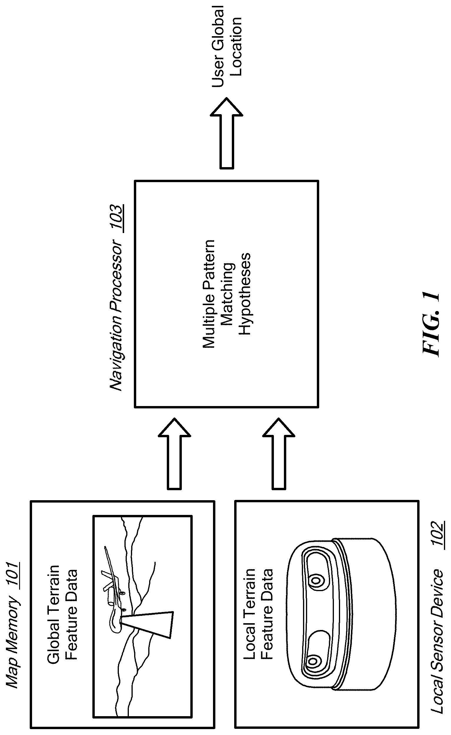
[0025] More specifically, embodiments of the present invention are directed to a computer-implemented method employing at least one hardware implemented navigation processor and a related computer program product for terrain feature matching navigation that can accurately determine a user's global location by measuring the distances and angles to local terrain features such as trees within a local area of a user. FIG. 1 shows a functional block diagram and FIG. 2 shows various steps in determining a user global location according to a broad embodiment. The navigation processor 103 operates to execute program instructions to obtain local terrain feature location data from a local sensor device 102 at a user location without a prior-known global position, step 201. The local terrain feature location data characterizes relative distances and directions to multiple local terrain features that are located nearest to the user location.
[0026] FIG. 3 shows an example of obtaining local terrain feature location data from a local sensor device according to an embodiment of the present invention. In the example shown in FIG. 3, the two-dimensional location of the center of the tree's trunk is defined based on a local reference frame with the observer at the origin. Filtering algorithms can be used to ensure the best probability that the local observations are also mapped globally--the markers might be colored with a first color that indicates trees that would be labeled as "detections" based on their ability to penetrate the forest canopy and therefore be identified by overhead imagery, while markers of a second color could represent false alarms that would potentially not be found in the same overhead imagery.
[0027] The navigation processor 103 also accesses at least one hardware memory device 101, step 202, that contains global terrain feature location data (i.e., map data) that characterizes relative distances and directions between multiple distinctive terrain features located in a defined terrain region in terms of absolute global location coordinates. These distinctive terrain features and their characteristic data represent combinations of trees in the defined terrain region whose locations are known. Each tree is assumed to have a point location.
[0028] The navigation processor 103 then compares the local terrain feature location data to the global terrain feature location data to develop multiple pattern matching hypotheses, step 203, wherein each pattern matching hypothesis characterizes a likelihood of a subset of the local terrain features matching a subset the global terrain features. Global location coordinates for the user location then are determined by the navigation processor 103, step 204, from the pattern matching hypotheses. As the user location varies across the terrain, the navigation processor 103 updates the global location coordinates, step 205.
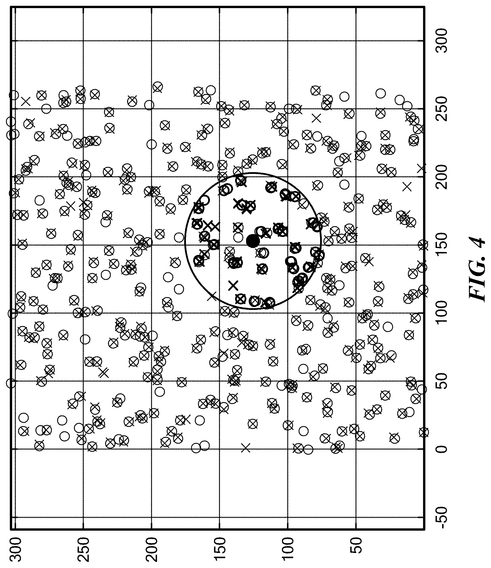
[0029] FIG. 4 illustrates the principle of these ideas in the form of a known two-dimensional map of global positions of trees in a region of forest, where the user position is the solid dot at the center of a circle of local tree observations that are used for pattern recognition against the known map of the forest. Embodiments can be thought of as involving three distinct conceptual parts: (1) collection of data prior to use of the program, (2) physical components used by personnel or vehicles on or near the ground to determine the location and orientation of trees near them, and (3) a multiple hypothesis positioning algorithm that ties together pattern matching and tracking techniques to accurately determine the global position of the observer.
[0030] Data collection and map building. To perform the pattern matching functionality, the navigation processor needs access to an accurate map of pre-determined terrain feature locations. This may also include tree classifications and related tree classification information. Such information and arrangements are used in other fields such as forest registries and environmental science, and the data may be collected using overhead imagery such as satellite or aerial imagery and tree crown delineation to identify and globally locate trees in a desired area.
[0031] FIG. 5 shows an example of an overhead image of a portion of a forest illustrating the pattern of crown delineation. Publicly accessible high-resolution (0.6 m resolution) satellite imagery previously has been used to show tree crown detection and identification for cataloging forests. Similar methods can be extended to detect and locate trees across defined terrain regions. In specific embodiments this may include classifying the trees by specific features such as color, shape, etc. For example, shape may be used to classify an object as a tree, building or statue. Length of shadow may be used to estimate height of the terrain feature, which may assist in the classification. Shape of the shadow also may be used to infer a profile shape of the terrain feature, which may assist in the classification. This all may be represented as a two-dimensional location of the tree in a North-East reference frame and a tree ID number, so that millions of trees could be stored on a single compact flash drive memory. Previous studies have shown accuracies of tree crown detection of up to 75% with satellite imagery and 85% with aerial imagery. Embodiments of the invention can incorporate these errors and still accurately determine the user's position. See Skurikhin, et al., "Unsupervised individual tree crown detection in high-resolution satellite imagery," Journal of Applied Remote Sensing, Vol. 10, Iss.1, p. 010501, Jan. 26, 2016, the entire contents of which are hereby incorporated by reference herein, for all purposes.
[0032] User Equipment Requirements.
[0033] Various existing equipment technologies can be used taking into account that the better the accuracy of the equipment in both identifying trees and locating the trees with respect to the observer, the more efficiently a given embodiment will be able to locate the observer against the global terrain feature location data. In some embodiments, a personal or UAV equipped LiDar unit, such as Scanse Sweep which boasts a 40 m range and relatively low cost of $350, may be used. Other potential sources of producing the local map are laser-range finding technology (<$200) or even camera imagery so long as range and orientation can be determined. The cost requirements for the necessary equipment can be application dependent so long as the equipment has the ability to identify trees or other terrain features in an observer's area and to locate the features in a two-dimensional space relative to the observer's frame of reference.
[0034] Multiple Hypothesis k-Closest Matching Algorithm.
[0035] The pattern matching functionality uses multiple hypothesis data association techniques to provide a robust determination of the observer's global position even in the presence of inaccurate or incomplete global and local mapping data. This can be done using a variation of a k-nearest vector search algorithm such as is used for star identification in star trackers. See Daniel Mortari, et al., "The Pyramid Star Identification Technique," Journal of the Astronautical Sciences, April, 1997, the entire contents of which are hereby incorporated by reference herein.
[0036] One challenge that is not a factor in star identification applications is the mapping uncertainty that is present in the global terrain feature location data. In star identification, star maps are well-known and well-defined so that there is little uncertainty in both the probability of false alarm as well as the assumed location of the stars. However, in forest settings, knowledge of the global terrain feature location data can be greatly affected by the method of mapping as well as the time between mapping the trees and the use of the information to determine the user location. Because of this greater uncertainty, multiple hypothesis data association techniques are needed to robustly handle and factor out the uncertainty when determining the user location.
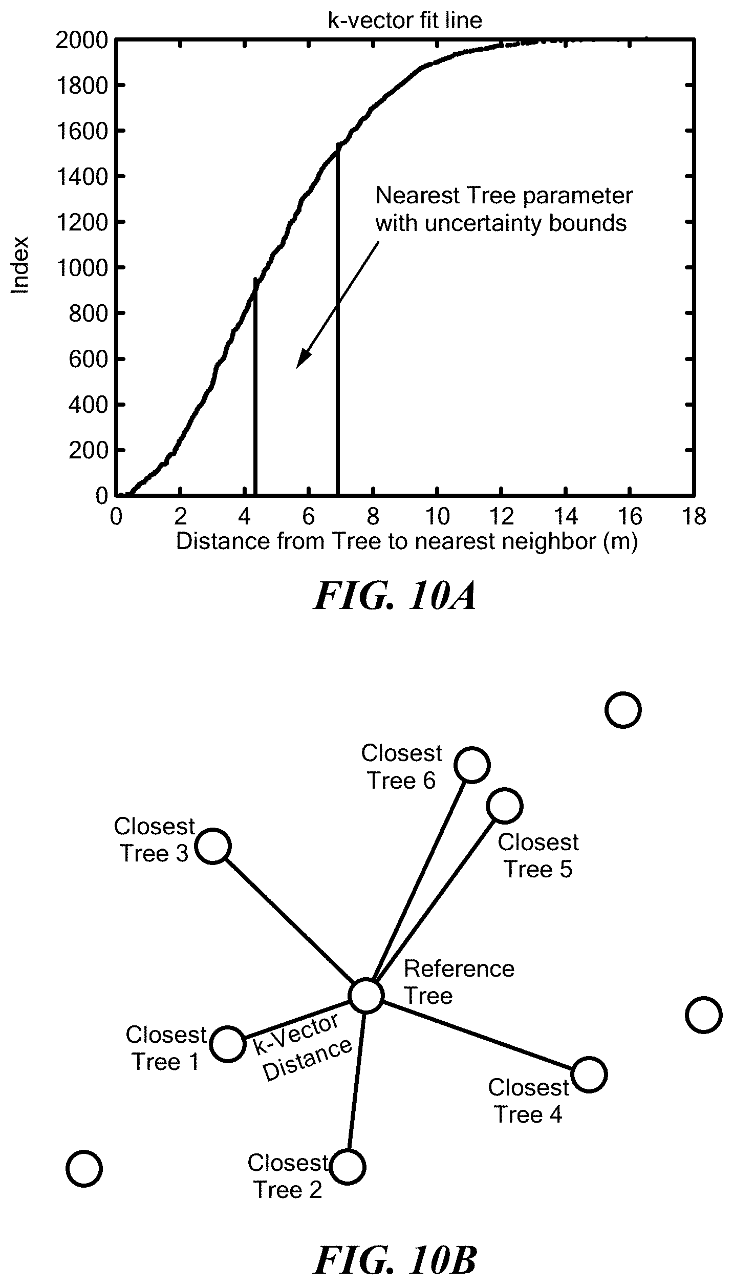
[0037] FIG. 6 shows the general process flow in one specific embodiment of a multiple hypothesis k-closest matching approach in which each global tree in the global terrain feature location data and each local tree in the local terrain feature location data is associated with the other trees around it and the local tree associations are then matched to the global tree associations to determine the user location relative to the global map. For star trackers, this pattern matching approach allows for the orientation of satellites or other vehicles in GPS-denied frameworks, but this same idea can be applied to work in a Lost-in-Forest scenario by treating each tree as a point location with known uncertainty in a two-dimensional terrain map.
[0038] The algorithm needs the information about each tree in both the local and global map to include the range to the k-closest other trees in both the local and the global area maps. The global area maps are generated as pre-process steps on the left side of FIG. 6 including generating a global tree location map, 601, and developing both the k-Vector best fit function and the feature vectors for all globally identified trees, 602. All the information about the global map and tree features can be stored in a global tree information database and made accessible to the observer when the application is needed. For example, FIG. 7A shows a two-dimensional map of a section of forest where each individual tree location is represented as a dot. For each tree object, the distance to closest k elements is computed to form a k--that describes the object location as shown in FIG. 7B. This means that only k+2 values are needed describe each tree object in the global map (x-y coordinates and the k-feature vector).
[0039] The active portion of the multiple hypothesis k-closest matching algorithm is shown on the right side of FIG. 6 and starts with the observer surveying their area (e.g., with LiDar equipment) to determine a local area map characterizing the locations of the surrounding trees, 603. Then, a local k-closest feature vector is developed for all identified trees, 604. FIGS. 8A-8B illustrate this idea showing how the local observations can be developed as k-feature vector in the local map.
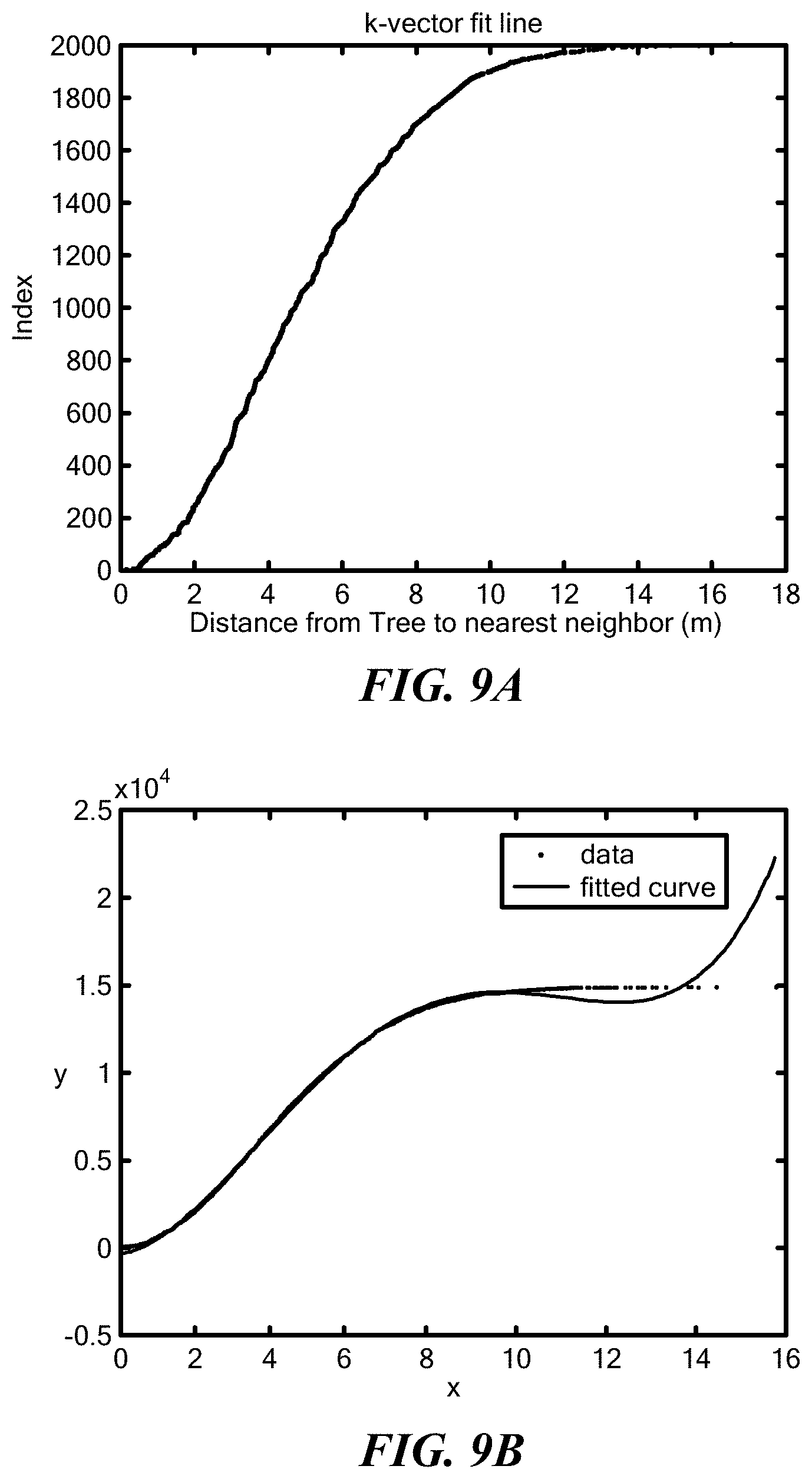
[0040] Next the pattern matching blocks including generating potential local-to-global tree hypotheses to determine hypothesized position of the observer, 605, for example, by taking the difference between locally observed position of a potential tree match and the position of the globally identified tree. FIG. 9A shows how this can be based on using a fit line for the first element of the feature vector for the k-vector search algorithm. Then as shown in FIG. 9B, a small portion of the feature vectors can be compared when determining a pass list using the k-Vector search algorithm; for example, using a fifth order best fit for the Gaussian CDF relationship between distance between trees and their index.
[0041] Due to high uncertainties, it will be useful to maintain multiple hypotheses of location as the false alarm density in this problem can be significant. Since the required functions to relate the global and local reference frames of the potential tree match are linear, the total uncertainty of the hypothesized position is the sum of the global map uncertainty and the observation uncertainty:
p.sub.Report=p.sub.TreeGlobal-p.sub.TreeLocal
P.sub.yyReport=.sigma..sup.2.sub.Global+.sigma..sup.2.sub.Local
The linearity of the reference frame transformation eliminates the need for an unscented transform (as might be required in star tracking applications) and therefore further reduces computation requirements.
[0042] With both the position estimate and the covariance matrix of all hypotheses determined, the remaining modules 606, 607, 608 and 609 can then iterate through each new locally observed tree and build confidence in the observer's true position as more tree matches gate with each other in the observer's reference frame. Once a proposed observer position is passed onto the multiple hypothesis positioning framework, the algorithm then compares the proposed observer position to all other proposed positions from other previous local-global tree matches. The comparison is done by way of a likelihood ratio test which is defined by the likelihood that a group of proposed tree matches provide the actual position of the observer over the likelihood that the group of proposed tree matches represent a false hypothesis of the observer's location. Following the MHP framework with each new locally observed tree that is passed through the algorithm, the most likely hypothesis is output and checked against a score threshold. If the score threshold is met then the observer can make use of the position estimate.
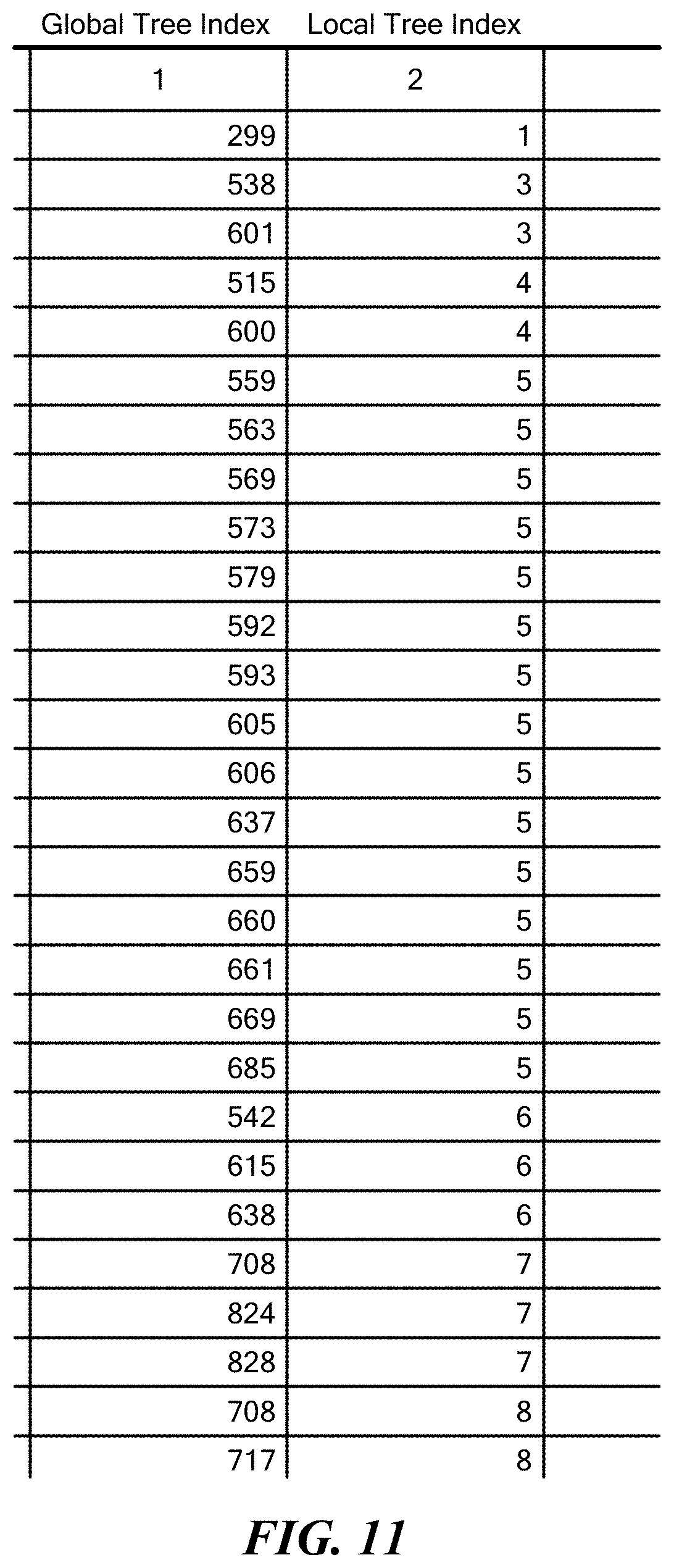
[0043] The algorithm searches through all the possible combinations of the local group to the global group. FIG. 10A shows using the predetermined fit line to refine the search similar to how it is used in the k-Vector Range Search Algorithm. To incorporate measurement uncertainty a range of potential tree IDs are extracted. Then as shown in FIG. 10B, the rest of the feature vector is used to further reduce the number of possible local-to-global tree matches. Matches may be considered only if enough (typically k-2) of the feature vector components pass an assigned threshold. FIG. 11 shows a pass list consists of all pairings that pass the threshold. All that is included in the pass list is the index of the global and local tree assignments. The pass list can then be used in the Multiple Hypothesis Positioning Framework to determine the correct observer position.
[0044] Other ways to make the algorithm more efficient and versatile include considering other features to pattern match between global and local tree maps, such as angle measurements to the closest trees (also common in star identification algorithms), size of tree trunks and/or canopies, tree type identification such as evergreen or deciduous trees and other distinguishable features. This is not an exhaustive list and essentially any features that can be easily determined in both aerial imagery and ground observation can be used for this algorithm to make it more robust and efficient.
[0045] In addition, the algorithm may be expanded from simply positioning to multiple hypothesis navigation with additional sensor fusion requirements, specifically the inclusion of IMU data to the algorithm. This development would also require the addition of velocity information of the user as an input into the algorithm. In order for the program to run efficiently in a navigation mode, as new trees are detected by the algorithm, a hash table of all the global trees may be used to only consider the most likely global tree matches for each current hypothesis.
[0046] In some embodiments, the trees are unclassified. That is, a tree is simply a static object whose location is known a priori, i.e., an object that is unlikely to move or be moved between a time when the object's location is ascertained for construction of the database and a time when the object is measured by the system to estimate the user's location. From this viewpoint, several types of objects may be considered trees. For example, literal trees, flagpoles, utility poles and obelisk statues may all be considered "trees."
[0047] In other embodiments, the trees may be classified. For example, literal trees may be classified as deciduous or evergreen. In another example, literal trees, flagpoles, utility poles, obelisk statues and buildings may each be so classified. In a classified embodiment, each tree's classification is stored in the database. When a measurement is taken in the environment to ascertain a user's location, the system automatically ascertains the classification of each observed tree, or the user enters this information. Having the classification of each observed tree increases accuracy and/or speed of the system, because observed trees are matched only with correspondingly classified trees in the database.
[0048] Embodiments of the invention may be implemented in part in any conventional computer programming language such as VHDL, SystemC, Verilog, ASM, etc. Alternative embodiments of the invention may be implemented as pre-programmed hardware elements, other related components, or as a combination of hardware and software components.
[0049] Embodiments can be implemented in part as a computer program product for use with a computer system. Such implementation may include a series of computer instructions fixed either on a tangible medium, such as a computer readable medium (e.g., a diskette, CD-ROM, ROM, or fixed disk) or transmittable to a computer system, via a modem or other interface device, such as a communications adapter connected to a network over a medium. The medium may be either a tangible medium (e.g., optical or analog communications lines) or a medium implemented with wireless techniques (e.g., microwave, infrared or other transmission techniques). The series of computer instructions embodies all or part of the functionality previously described herein with respect to the system. Those skilled in the art should appreciate that such computer instructions can be written in a number of programming languages for use with many computer architectures or operating systems. Furthermore, such instructions may be stored in any memory device, such as semiconductor, magnetic, optical or other memory devices, and may be transmitted using any communications technology, such as optical, infrared, microwave, or other transmission technologies. It is expected that such a computer program product may be distributed as a removable medium with accompanying printed or electronic documentation (e.g., shrink wrapped software), preloaded with a computer system (e.g., on system ROM or fixed disk), or distributed from a server or electronic bulletin board over the network (e.g., the Internet or World Wide Web). Of course, some embodiments of the invention may be implemented as a combination of both software (e.g., a computer program product) and hardware. Still other embodiments of the invention are implemented as entirely hardware, or entirely software (e.g., a computer program product).
[0050] Although various exemplary embodiments of the invention have been disclosed, it should be apparent to those skilled in the art that various changes and modifications can be made which will achieve some of the advantages of the invention without departing from the true scope of the invention.
* * * * *
D00000
D00001
D00002
D00003
D00004
D00005
D00006
D00007
D00008
D00009
D00010
D00011
XML
uspto.report is an independent third-party trademark research tool that is not affiliated, endorsed, or sponsored by the United States Patent and Trademark Office (USPTO) or any other governmental organization. The information provided by uspto.report is based on publicly available data at the time of writing and is intended for informational purposes only.
While we strive to provide accurate and up-to-date information, we do not guarantee the accuracy, completeness, reliability, or suitability of the information displayed on this site. The use of this site is at your own risk. Any reliance you place on such information is therefore strictly at your own risk.
All official trademark data, including owner information, should be verified by visiting the official USPTO website at www.uspto.gov. This site is not intended to replace professional legal advice and should not be used as a substitute for consulting with a legal professional who is knowledgeable about trademark law.