Routing device that modifies route guidance based on user input
Ettinger , et al. A
U.S. patent number 10,739,148 [Application Number 16/059,969] was granted by the patent office on 2020-08-11 for routing device that modifies route guidance based on user input. This patent grant is currently assigned to Uber Technologies, Inc.. The grantee listed for this patent is Uber Technologies, Inc.. Invention is credited to Esther Abramovich Ettinger, Gil Emanuel Fuchs.


| United States Patent | 10,739,148 |
| Ettinger , et al. | August 11, 2020 |
| **Please see images for: ( Certificate of Correction ) ** |
Routing device that modifies route guidance based on user input
Abstract
A vehicle routing device that determines a route from an origin to a destination including route guidance. The route guidance is modified based on user input. The modification can supply increased or reduced route guidance at intervals along the route. Route guidance may be modified to incorporate landmarks and personal contacts.
| Inventors: | Ettinger; Esther Abramovich (Laguna Beach, CA), Fuchs; Gil Emanuel (Nes Tziona, IL) | ||||||||||
|---|---|---|---|---|---|---|---|---|---|---|---|
| Applicant: |
|
||||||||||
| Assignee: | Uber Technologies, Inc. (San
Francisco, CA) |
||||||||||
| Family ID: | 64657913 | ||||||||||
| Appl. No.: | 16/059,969 | ||||||||||
| Filed: | August 9, 2018 |
Prior Publication Data
| Document Identifier | Publication Date | |
|---|---|---|
| US 20180364057 A1 | Dec 20, 2018 | |
Related U.S. Patent Documents
| Application Number | Filing Date | Patent Number | Issue Date | ||
|---|---|---|---|---|---|
| 15003831 | Jan 22, 2016 | 10066950 | |||
| 14054320 | Oct 15, 2013 | 9243920 | |||
| 61716321 | Oct 19, 2012 | ||||
| Current U.S. Class: | 1/1 |
| Current CPC Class: | G01C 21/3691 (20130101); G01C 21/3641 (20130101); G01C 21/3667 (20130101); G01C 21/3415 (20130101); G01C 21/3484 (20130101); G01C 21/34 (20130101) |
| Current International Class: | G01C 21/34 (20060101); G01C 21/36 (20060101) |
References Cited [Referenced By]
U.S. Patent Documents
| 4974170 | November 1990 | Bouve et al. |
| 5470233 | November 1995 | Fruchterman et al. |
| 5682525 | October 1997 | Bouve et al. |
| 5784059 | July 1998 | Morimoto et al. |
| 6115669 | September 2000 | Watanabe et al. |
| 6339746 | January 2002 | Sugiyama et al. |
| 6427118 | July 2002 | Suzuki |
| 6510379 | January 2003 | Hasegawa et al. |
| 6636805 | October 2003 | Tada et al. |
| 6728635 | April 2004 | Hamada et al. |
| 6820005 | November 2004 | Matsuda et al. |
| 6944539 | September 2005 | Yamada et al. |
| 7333889 | February 2008 | Hashizume |
| 7395153 | July 2008 | Nesbitt et al. |
| 7463972 | December 2008 | Yamada et al. |
| 7487038 | February 2009 | Kitagawa et al. |
| 7487039 | February 2009 | Rumbo et al. |
| 7532899 | May 2009 | Wilson et al. |
| 7598321 | October 2009 | Talkowski |
| 7831381 | November 2010 | Thota |
| 7933897 | April 2011 | Jones et al. |
| 7957871 | June 2011 | Echeruo |
| 8688367 | April 2014 | Mauderer |
| 9243920 | January 2016 | Ettinger et al. |
| 10066950 | September 2018 | Ettinger et al. |
| 2001/0007968 | July 2001 | Shimazu |
| 2002/0022923 | February 2002 | Hirabayashi et al. |
| 2002/0103599 | August 2002 | Sugiyama et al. |
| 2002/0120397 | August 2002 | Kepler |
| 2004/0167706 | August 2004 | Becker |
| 2004/0192311 | September 2004 | Koskinen et al. |
| 2004/0205394 | October 2004 | Plutowski |
| 2004/0254723 | December 2004 | Tu |
| 2005/0065779 | March 2005 | Odinak |
| 2005/0227676 | October 2005 | De Vries |
| 2005/0256635 | November 2005 | Gardner et al. |
| 2006/0069503 | March 2006 | Suomela et al. |
| 2006/0157621 | July 2006 | Santos Rubio et al. |
| 2007/0016368 | January 2007 | Chapin et al. |
| 2007/0078596 | April 2007 | Grace |
| 2007/0078598 | April 2007 | Watanabe et al. |
| 2007/0106469 | May 2007 | Ishizaki |
| 2007/0115142 | May 2007 | Nakashima |
| 2007/0125967 | June 2007 | Lapanik et al. |
| 2007/0143345 | June 2007 | Jones et al. |
| 2007/0299607 | December 2007 | Cubillo |
| 2008/0109718 | May 2008 | Narayanaswami |
| 2008/0140310 | June 2008 | Graef |
| 2008/0147319 | June 2008 | Cubillo |
| 2008/0195312 | August 2008 | Aaron et al. |
| 2008/0262714 | October 2008 | Abramovich Ettinger |
| 2008/0262717 | October 2008 | Ettinger |
| 2008/0319652 | December 2008 | Moshfeghi |
| 2008/0319658 | December 2008 | Horvitz et al. |
| 2008/0319659 | December 2008 | Horvitz et al. |
| 2008/0319660 | December 2008 | Horvitz et al. |
| 2009/0005981 | January 2009 | Forstall et al. |
| 2009/0222201 | September 2009 | Jung |
| 2009/0281726 | November 2009 | Byrne |
| 2010/0094536 | April 2010 | Lee et al. |
| 2010/0324818 | December 2010 | Gellatly et al. |
| 2012/0197690 | August 2012 | Agulnek |
| 2014/0358425 | December 2014 | Seth et al. |
| 2016/0138927 | May 2016 | Ettinger et al. |
| WO-2005098362 | Oct 2005 | WO | |||
| WO-2007041547 | Apr 2007 | WO | |||
Other References
|
"U.S. Appl. No. 11/785,284, Final Office Action dated Jan. 30, 2014", 13 pgs. cited by applicant . "U.S. Appl. No. 11/785,284, Final Office Action dated Apr. 28, 2011", 6 pgs. cited by applicant . "U.S. Appl. No. 11/785,284, Non Final Office Action dated Jan. 16, 2015", 15 pgs. cited by applicant . "U.S. Appl. No. 11/785,284, Non Final Office Action dated Jun. 28, 2010", 7 pgs. cited by applicant . "U.S. Appl. No. 11/785,284, Non Final Office Action dated Sep. 24, 2009", 8 pgs. cited by applicant . "U.S. Appl. No. 11/785,284, Non Final Office Action dated Oct. 14, 2010", 7 pgs. cited by applicant . "U.S. Appl. No. 11/785,294, Final Office Action dated Feb. 26, 2013", 22 pgs. cited by applicant . "U.S. Appl. No. 11/785,294, Final Office Action dated Mar. 7, 2011", 20 pgs. cited by applicant . "U.S. Appl. No. 11/785,294, Non Final Office Action dated Jun. 21, 2012", 18 pgs. cited by applicant . "U.S. Appl. No. 11/785,294, Non Final Office Action dated Aug. 19, 2010", 12 pgs. cited by applicant . "U.S. Appl. No. 11/785,294, Non Final Office Action dated Dec. 19, 2019", 7 pgs. cited by applicant . "U.S. Appl. No. 14/054,320, Final Office Action dated Feb. 11, 2015", 11 pgs. cited by applicant . "U.S. Appl. No. 14/054,320, Non Final Office Action dated May 29, 2015", 8 pgs. cited by applicant . "U.S. Appl. No. 14/054,320, Non Final Office Action dated Aug. 29, 2014", 9 pgs. cited by applicant . "U.S. Appl. No. 14/054,320, Notice of Allowance dated Sep. 15, 2015", 7 pgs. cited by applicant . "U.S. Appl. No. 14/054,320, Response filed May 6, 2015 to Final Office Action dated Feb. 11, 2015", 15 pgs. cited by applicant . "U.S. Appl. No. 14/054,320, Response filed Aug. 31, 2015 to Non Final Office Action dated May 29, 2015", 16 pgs. cited by applicant . "U.S. Appl. No. 14/054,320, Response filed Nov. 26, 2014 to Non Final Office Action dated Aug. 29, 2014", 15 pgs. cited by applicant . "U.S. Appl. No. 15/003,831, Examiner Interview Summary dated Sep. 19, 2017", 2 pgs. cited by applicant . "U.S. Appl. No. 15/003,831, Final Office Action dated Apr. 19, 2017", 13 pgs. cited by applicant . "U.S. Appl. No. 15/003,831, Non Final Office Action dated Aug. 23, 2016", 11 pgs. cited by applicant . "U.S. Appl. No. 15/003,831, Non Final Office Action dated Oct. 25, 2017", 13 pgs. cited by applicant . "U.S. Appl. No. 15/003,831, Notice of Allowance dated May 10, 2018", 8 pgs. cited by applicant . "U.S. Appl. No. 15/003,831, Response filed Feb. 20, 2017 to Non Final Office Action dated Aug. 23, 2016", 8 pgs. cited by applicant . "U.S. Appl. No. 15/003,831, Response filed Sep. 19, 2017 to Final Office Action dated Apr. 19, 2017", 13 pgs. cited by applicant . "U.S. Appl. No. 15/003,831 Response filed Mar. 23, 2018 to Non-Final Office Action dated Oct. 26, 2017.pdf", 12 pgs. cited by applicant . Caduff, David, et al., "The Landmark Spider: Representing Landmark Knowledge for Wayfinding Tasks", American Association for Artificial Intelligence (www.aaai.org), (2002), 1-6. cited by applicant . Ruetschi, Urs-Jakob, et al., "Routing by Landmarks", 6th Swiss Transport Research Conference, Monte Verita / Ascona, (Mar. 15-17, 2006). cited by applicant . U.S. Appl. No. 14/054,320 U.S. Pat. No. 9,243,920, filed Oct. 15, 2013, System and Method for Adapting the Routing Information Provided by a Mapping or Routing Device. cited by applicant . U.S. Appl. No. 15/003,831, filed Jan. 22, 2016, Routing Device That Modifies Route Guidance Based on User Input. cited by applicant. |
Primary Examiner: Sood; Anshul
Attorney, Agent or Firm: Schwegman Lundberg & Woessner, P.A.
Parent Case Text
CLAIM OF PRIORITY
This application is a continuation of and claims the benefit of priority to U.S. patent application Ser. No. 15/003,831 filed on 2016 Jan. 22 titled "ROUTING DEVICE THAT MODIFIES ROUTE GUIDANCE BASED ON USER INPUT" which is a continuation of and claims the benefit of priority to U.S. patent application Ser. No. 14/054,320 filed on 2013 Oct. 15 titled "SYSTEM AND METHOD FOR ADAPTING THE ROUTING INFORMATION PROVIDED BY A MAPPING OR ROUTING DEVICE" which in turn claims priority to U.S. Provisional Patent Application titled "SYSTEM AND METHOD FOR ADAPTING THE ROUTING INFORMATION PROVIDED BY A MAPPING OR ROUTING DEVICE", Application No. 61/716,321, filed 2012 Oct. 19; which applications are herein incorporated by reference in their entireties.
CROSS-REFERENCE TO RELATED APPLICATIONS
This application is related to U.S. Patent Application titled "DEVICE, SYSTEM AND METHOD OF CONTACT-BASED ROUTING AND GUIDANCE", application Ser. No. 11/785,284, filed Apr. 17, 2007; and U.S. Patent Application titled "DEVICE, SYSTEM AND METHOD OF LANDMARK-BASED ROUTING AND GUIDANCE", application Ser. No. 11/785,294, filed Apr. 17, 2007, each of which above applications are herein incorporated by reference.
Claims
What is claimed:
1. A computer-implemented method comprising: calculating, by a computer system having at least one hardware processor, a route and route guidance from an origin to a destination, the route guidance comprising textual directions to the destination; modifying, by the computer system, the calculated route guidance as a function of a high traffic situation along the calculated route during travel of a user device between the origin and the destination, the modifying including increasing a level of detail of the textual directions of the calculated route guidance based on the high traffic situation along the calculated route; and transmitting, by the computer system, the modified calculated route guidance to the user device for presentation on the user device.
2. The computer-implemented method of claim 1, wherein the increasing the level of detail of the textual directions of the calculated route guidance comprises increasing the level of detail of the textual directions from a first level of detail to a second level of detail, the first level of detail corresponding to presenting some, but not all, of the calculated route guidance, and the second level of detail corresponding to presenting more of the calculated route guidance than the first level of detail.
3. The computer-implemented method of claim 2, wherein the second level of detail corresponds to presenting all of the calculated route guidance.
4. The computer-implemented method of claim 1, further comprising: determining, by the computer system, a location of the user device during travel of the user device between the origin and the destination; and omitting, by the computer system, the calculated route guidance from presentation on the user device during a portion of the travel of the user device between the origin and the destination corresponding to the determined location based on the determined location of the user device.
5. The computer-implemented method of claim 4, wherein: the modified calculated route guidance is displayed on the user device via a navigation application on the user device; and the omitting the calculated route guidance from presentation comprises causing the navigation application to appear to have gone asleep during the portion of the travel of the user device between the origin and the destination.
6. The computer-implemented method of claim 1, wherein the user device comprises a display device configured to display the route or part of the route on a map and the modified route guidance on the map.
7. The computer-implemented method of claim 1, wherein the user device comprises an in-car global positioning system (GPS) device or a smartphone.
8. A device comprising: at least one computer processor; and a non-transitory computer readable medium having instructions stored thereon which, when read and executed by the at least one computer processor, cause the at least one computer processor to perform operations comprising: calculating a route and route guidance from an origin to a destination, the route guidance comprising textual directions to the destination; modifying the calculated route guidance as a function of a high traffic situation along the calculated route during travel of a user device between the origin and the destination, the modifying including increasing a level of detail of the textual directions of the calculated route guidance based on the high traffic situation along the calculated route; and transmitting the modified calculated route guidance to the user device for presentation on the user device.
9. The device of claim 8, wherein the increasing the level of detail of the textual directions of the calculated route guidance comprises increasing the level of detail of the textual directions from a first level of detail to a second level of detail, the first level of detail corresponding to presenting some, but not all, of the calculated route guidance, and the second level of detail corresponding to presenting more of the calculated route guidance than the first level of detail.
10. The device of claim 9, wherein the second level of detail corresponds to presenting all of the calculated route guidance.
11. The device of claim 8, wherein the operations further comprise: determining a location of the user device during travel of the user device between the origin and the destination; and omitting the calculated route guidance from presentation on the user device during a portion of the travel of the user device between the origin and the destination corresponding to the determined location based on the determined location of the user device.
12. The device of claim 11, wherein: the modified calculated route guidance is displayed on the user device via a navigation application on the user device; and the omitting the calculated route guidance from presentation comprises causing the navigation application to appear to have gone asleep during the portion of the travel of the user device between the origin and the destination.
13. The device of claim 8, wherein the user device comprises a display device configured to display the route or part of the route on a map and the modified route guidance on the map.
14. The device of claim 8, wherein the user device comprises an in-car global positioning system (GPS) device or a smartphone.
15. A non-transitory computer readable medium having instructions stored thereon which, when read and executed by at least one computer processor, cause the at least one computer processor to perform operations comprising: calculating a route and route guidance from an origin to a destination, the route guidance comprising textual directions to the destination, modifying the calculated route guidance as a function of a high traffic situation along the calculated route during travel of a user device between the origin and the destination based on the determined location of the user device, the modifying including increasing a level of detail of the textual directions of the calculated route guidance based on the high traffic situation along the calculated route; and transmitting the modified calculated route guidance to the user device for presentation on the user device.
16. The non-transitory computer readable medium of claim 15, wherein the increasing the level of detail of the textual directions of the calculated route guidance comprises increasing the level of detail of the textual directions from a first level of detail to a second level of detail, the first level of detail corresponding to presenting some, but not all, of the calculated route guidance, and the second level of detail corresponding to presenting more of the calculated route guidance than the first level of detail.
17. The non-transitory computer readable medium of claim 16, wherein the second level of detail corresponds to presenting all of the calculated route guidance.
18. The non-transitory computer readable medium of claim 15, wherein the operations further comprise: determining a location of the user device during travel of the user device between the origin and the destination; and omitting the calculated route guidance from presentation on the user device during a portion of the travel of the user device between the origin and the destination corresponding to the determined location based on the determined location of the user device.
19. The non-transitory computer readable medium of claim 18, wherein: the modified calculated route guidance is displayed on the user device via a navigation application on the user device; and the omitting the calculated route guidance from presentation comprises causing the navigation application to appear to have gone asleep during the portion of the travel of the user device between the origin and the destination.
20. The non-transitory computer readable medium of claim 15, wherein the user device comprises a display device configured to display the route or part of the route on a map and the modified route guidance on the map.
Description
COPYRIGHT NOTICE
A portion of the disclosure of this patent document contains material which is subject to copyright protection. The copyright owner has no objection to the facsimile reproduction by anyone of the patent document or the patent disclosure, as it appears in the Patent and Trademark Office patent file or records, but otherwise reserves all copyright rights whatsoever.
FIELD OF INVENTION
Embodiments of the invention are generally related to systems for mapping and route guidance, and are particularly related to a system and method for adapting the routing information provided by a mapping or routing device.
BACKGROUND
A typical mapping or routing device (e.g., an in-car global positioning system (GPS), or a handheld smartphone device that includes a mapping software) can be used to display a map of a geographical area selected by a user, and provide routing information, such as driving directions that the user can follow to drive from a first geographical location (origin), to a second geographical location (destination).
In some instances, the routing information can include a graphical component (e.g., a graphical representation of a suggested driving route displayed in combination with a graphical map), coupled with a textual or audio component (e.g., directions to the user on how to drive in order to reach the destination, such as "Drive north on Broadway for a distance of one mile", "Turn right at the corner of 37th Street", or the like).
However, a problem with current mapping or routing devices is that they generally operate independently of a user's/driver's familiarity with a particular geographical area, and as such are not designed to adapt accordingly. This is the general area that embodiments of the invention are designed to address.
SUMMARY
Described herein is a system and method for adapting the routing information provided by a mapping or routing device. In accordance with an embodiment the system comprises a data collection component (e.g., one or more GPS, accelerometer, or other means of determining location and/or movement), and a route calculation logic that can use information about a first geographical location (origin), and a second geographical location (destination), to calculate a routing information, such as driving directions that a user can follow to drive from the origin to the destination. An information filtering application adapts the amount of information that will be presented to the user at a particular location, moment in time, or based on other criteria. In accordance with an embodiment, the information filtering application can, in some instances, be provided as a third-party application; for example, in the case of a mapping/routing device incorporated into a smartphone device that includes a mapping software, the information filtering application can be provided as a downloadable or otherwise installable third-party software application that can be installed into the smartphone device and used to adapt the routing information the device provides to a user.
BRIEF DESCRIPTION OF THE FIGURES
FIG. 1 illustrates a system for adapting the routing information provided by a mapping or routing device, in accordance with an embodiment.
FIG. 2 further illustrates a system for adapting the routing information provided by a mapping or routing device, in accordance with an embodiment.
FIG. 3 illustrates a system for adapting the routing information provided by a mapping or routing device, in accordance with another embodiment.
FIG. 4 illustrates the use of a system for adapting the routing information provided by a mapping or routing device, in accordance with an embodiment.
FIG. 5 illustrates a method of adapting the routing information provided by a mapping or routing device, in accordance with an embodiment.
DETAILED DESCRIPTION
As described above, a typical mapping or routing device (e.g. an in-car global positioning system (GPS), or a handheld smartphone device that includes a mapping software) can be used to display a map of a geographical area selected by a user, and provide routing information, such as driving directions that the user can follow to drive from a first geographical location (origin), to a second geographical location (destination). However, a problem with current mapping or routing devices is that they generally operate independently of a user's/driver's familiarity with a particular geographical area, and as such are not designed to adapt accordingly.
Embodiments of the invention are generally related to systems for mapping and route guidance, and are particularly related to a system and method for adapting the routing information provided by a mapping or routing device. In accordance with an embodiment, the system comprises a data collection component (e.g., one or more GPS, accelerometer, or other means of determining location and/or movement), and a route calculation logic that can use information about the origin and the destination, to calculate a routing information, such as driving directions that a user can follow to drive from the origin to the destination.
In accordance with an embodiment, an information filtering application, which in some instances can be provided as a third-party application, can, based on a user-specified setting, determine the type or how much routing information the system should provide to the user. For example, a "volume" or "slider" type control, or an "expert" software setting, or other means, can be provided to allow the user to instruct the system to provide more or less routing information in appropriate circumstances. Such settings can be manually or directly modified by the user, or can be automatically determined by an external application based on various criteria.
By way of illustration, the settings can be used to instruct the system that routing information be turned off, with no routing information provided; or alternatively that routing information be turned on, with a reduced level of routing information provided; or alternatively that routing information be turned on, with a full level of routing information provided; or another level of adapted map/routing information. Adjusting the level of routing information is akin to adjusting the volume of detail provided to the user, from no detail to all available detail. A special case of the above is for the system to completely turn off the providing of routing information, say for a particular portion of a route, and then to turn on all routing information for another portion of the route.
In accordance with an embodiment, the user-specified settings can specify that the routing information remain at a particular level, e.g., for a particular environment or user. Alternatively, the settings can specify that the routing information should vary for the particular environment or user according to e.g., the user's current location/address when compared to the destination, or the user's lat/long position, or a time value such as when the user is within, e.g., 10 minutes from their destination; or when the user has traveled a particular percentage, e.g., 80% along a particular routing path toward the destination.
When, according to the settings and the determination of the above criteria, the system determines that a reduced level of routing information should be provided, say because the user is familiar with the general location, and is far away from their destination, then, in accordance with an embodiment, the system can provide a reduced level of routing information, or in the special case described above, routing information can be turned off completely for a time period.
Subsequently, when, according to the settings and a determination of the above criteria, the system determines that an increased level of routing information should be provided, say because the user is nearing their destination, then, in accordance with an embodiment, the system can provide a correspondingly increased, or full level of routing information.
Although the above embodiments generally describe that the user/vehicle's current location, time and/or other criteria is used by the route calculation logic to provide an adapted map/routing information, in accordance with various embodiments the route calculation logic can alternatively or additionally use personal contacts information and/or landmark information, such as that described respectively in U.S. Patent Application titled "DEVICE, SYSTEM AND METHOD OF CONTACT-BASED ROUTING AND GUIDANCE", application Ser. No. 11/785,284, filed Apr. 17, 2007; and U.S. Patent Application titled "DEVICE, SYSTEM AND METHOD OF LANDMARK-BASED ROUTING AND GUIDANCE", application Ser. No. 11/785,294, filed Apr. 17, 2007, herein incorporated by reference.
FIG. 1 illustrates a system for adapting the routing information provided by a mapping or routing device, in accordance with an embodiment. As shown in FIG. 1, a mapping/routing device 102 can be provided as, e.g., an in-car GPS device, a suitably-equipped smartphone device, or another type of mapping/routing device.
In accordance with an embodiment, the mapping/routing device provides a mapping/routing environment 103, which includes a navigation application (navapp) 104 having a data collection component 106 (e.g., one or more GPS, accelerometers, or other means of determining the location and movement of the user), together with a route calculation logic 108 that can use information about a first geographical location (origin), and a second geographical location (destination), in combination with the data collection component, to calculate a routing information, such as driving directions that the user can follow to drive from the origin to the destination. The route calculation logic can include an origin-destination map routing component 110 that calculates a routing information, such as a map/routing display 111, from the origin to the destination.
In accordance with an embodiment, an information filtering application 113 can be provided to adapt the amount of information that will be presented by the system to the user, including an adapted map/routing display. In accordance with an embodiment, the information filtering application can be provided as a third-party application. For example, in the case of a mapping/routing device incorporated into a smartphone device that includes a mapping software, the information filtering application can be provided as a downloadable or otherwise installable third-party software application that can be installed into the smartphone device and used to adapt the routing information the device provides to a user.
In accordance with an embodiment, a user 101 can specify a setting 120 (such as the use of a "volume" or "slider" type control, or an "expert" software setting), which is used by the information filtering application, to configure 121 and thereafter adapt the amount of map/routing information originally provided 130 by the navapp, and present it instead as adapted map/routing information 122 to the user at a particular location, moment in time, or based on other criteria as described in further detail below.
In accordance with an embodiment, the information filtering application (e.g., third-party application) thereafter adapts the level of routing information provided by the navapp, e.g., by giving the appearance that the navapp has "gone to sleep" and is then woken up at a particular location, as specified by the configuration as, e.g., a latlong, street address, distance from destination, time from destination, or other criteria.
FIG. 2 further illustrates a system for adapting the routing information provided by a mapping or routing device, in accordance with an embodiment. As shown in FIG. 2, the information filtering application can adapt the amount of map/routing information originally provided by the navapp, and present it instead as different levels of adapted map/routing information 136, 137, 138, to the user at different, e.g., locations or moments in time 132, 133, and 134. In accordance with an embodiment, exceptions can be made for unusual circumstances, e.g., in the event of an unusual traffic situation the level of adapted map/routing information may be temporarily increased.
FIG. 3 illustrates a system for adapting the routing information provided by a mapping or routing device, in accordance with another embodiment. As shown in FIG. 3, in accordance with an embodiment, the navapp can include a navapp API that enables access by third-party applications to the navapp. In such embodiments, in addition to the information filtering application operating as above to adapt the amount of map/routing information originally provided by the navapp, the information filtering application can intercept, read, or otherwise access map/routing information 140, and thereafter adapt the amount of information that will be presented by the system to a user.
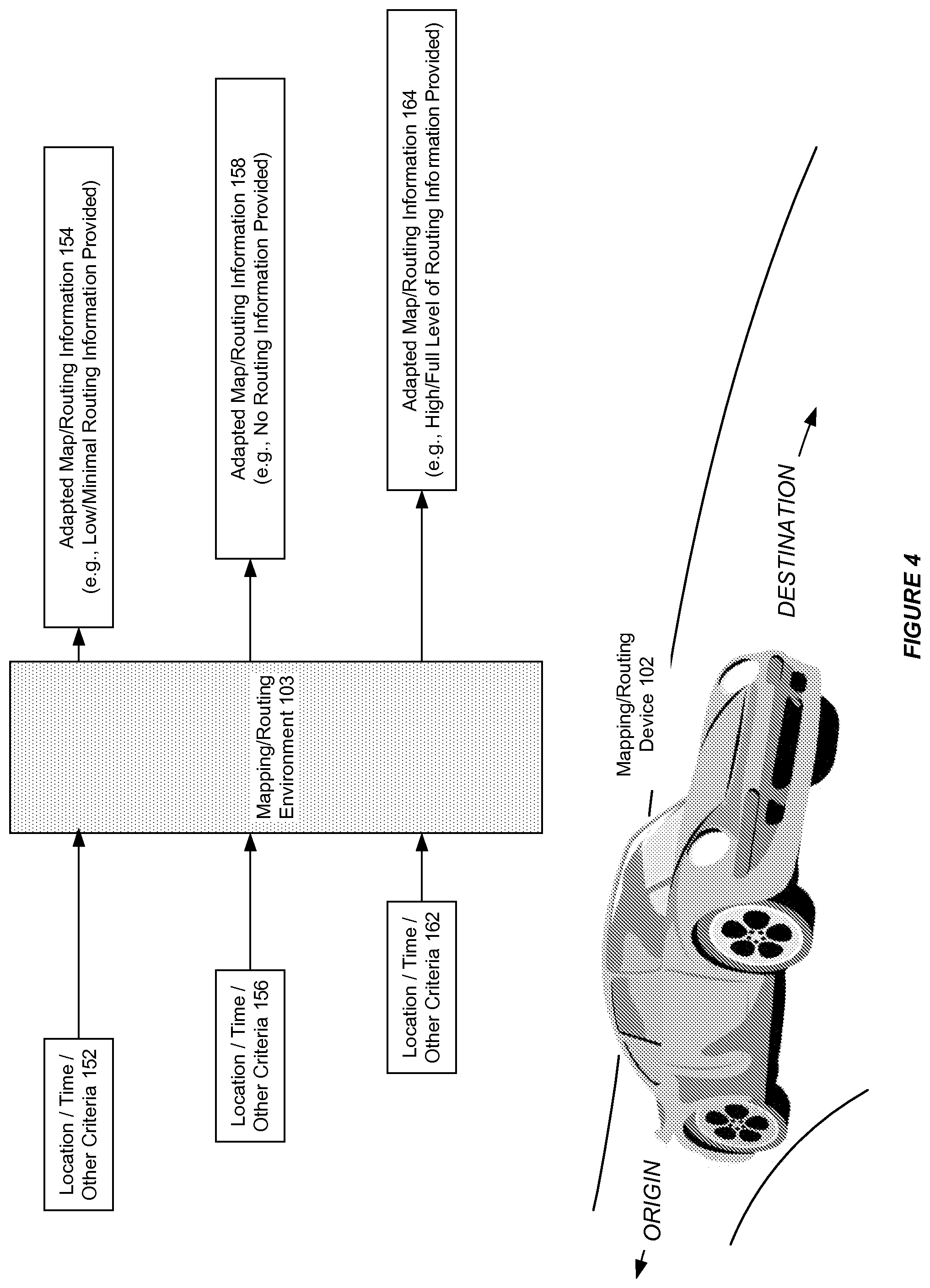
FIG. 4 illustrates the use of a system for adapting the routing information provided by a mapping or routing device, in accordance with an embodiment. As shown in FIG. 4, in accordance with an embodiment, the mapping/routing device can be provided, e.g., as an in-car GPS device for use by a driver in obtaining driving directions from an origin location to a destination location. At a particular location or moment in time 152, or based on other criteria as determined by the information filtering application configuration, the mapping/routing device can provide a particular level of adapted map/routing information 154, such as routing information turned off, with no routing information.
At a subsequent location or moment in time 156, or based on other criteria as determined by the information filtering application configuration, the mapping/routing device can provide a different level of adapted map/routing information 158, such as routing information turned on, with reduced level of routing information.
At a yet subsequent location or moment in time 162, or based on other criteria as determined by the information filtering application configuration, the mapping/routing device can provide a yet different level of adapted map/routing information 164, such as routing information turned on, with full level of routing information, or another level of adapted map/routing information.
FIG. 5 illustrates a method of adapting the routing information provided by a mapping or routing device, in accordance with an embodiment. As shown in FIG. 5, at step 170, the system receives one or more user-specified and/or third-party and/or external-specified configuration.
At step 172, the system receives an instruction from a user to provide map/routing between a first geographical location (origin), and a second geographical location (destination).
At step 174, during travel towards destination the system determines the user/vehicle's current location, time and/or other criteria.
At step 176, depending on the configuration, and the user/vehicle's current location, time and/or other criteria, the system provides an adapted map/routing information (e.g., routing information turned off, with no routing information; routing information turned on, with reduced level of routing information; routing information turned on, with full level of routing information; or another level of adapted map/routing information).
The present invention may be conveniently implemented using one or more conventional general purpose or specialized digital computers or microprocessors programmed according to the teachings of the present disclosure, or a portable device (e.g., a smartphone, PDA, computer or other device). Appropriate software coding can readily be prepared by skilled programmers based on the teachings of the present disclosure, as will be apparent to those skilled in the software art.
In some embodiments, the present invention includes a computer program product which is a non-transitory storage medium (media) having instructions stored thereon/in which can be used to program a computer to perform any of the processes of the present invention. The storage medium can include, but is not limited to, any type of disk including floppy disks, optical discs, DVD, CD-ROMs, microdrive, and magneto-optical disks, ROMs, RAMs, EPROMs, EEPROMs, DRAMs, VRAMs, flash memory devices, magnetic or optical cards, nanosystems (including molecular memory ICs), or any type of media or device suitable for storing instructions and/or data.
The foregoing description of the present invention has been provided for the purposes of illustration and description. It is not intended to be exhaustive or to limit the invention to the precise forms disclosed. The embodiments were chosen and described in order to best explain the principles of the invention and its practical application, thereby enabling others skilled in the art to understand the invention for various embodiments and with various modifications that are suited to the particular use contemplated.
* * * * *
D00000
D00001
D00002
D00003
D00004
D00005
XML
uspto.report is an independent third-party trademark research tool that is not affiliated, endorsed, or sponsored by the United States Patent and Trademark Office (USPTO) or any other governmental organization. The information provided by uspto.report is based on publicly available data at the time of writing and is intended for informational purposes only.
While we strive to provide accurate and up-to-date information, we do not guarantee the accuracy, completeness, reliability, or suitability of the information displayed on this site. The use of this site is at your own risk. Any reliance you place on such information is therefore strictly at your own risk.
All official trademark data, including owner information, should be verified by visiting the official USPTO website at www.uspto.gov. This site is not intended to replace professional legal advice and should not be used as a substitute for consulting with a legal professional who is knowledgeable about trademark law.