System, method, and computer program product for automated discovery, curation and editing of online local content
Castillo , et al.
U.S. patent number 10,324,996 [Application Number 15/168,978] was granted by the patent office on 2019-06-18 for system, method, and computer program product for automated discovery, curation and editing of online local content. This patent grant is currently assigned to GROUPON, INC.. The grantee listed for this patent is Groupon, Inc.. Invention is credited to Roger Henry Castillo, Thomas Jack.


View All Diagrams
| United States Patent | 10,324,996 |
| Castillo , et al. | June 18, 2019 |
| **Please see images for: ( Certificate of Correction ) ** |
System, method, and computer program product for automated discovery, curation and editing of online local content
Abstract
A method for quantifying localness of content can be organized into several stages of information acquisition and processing, with each stage focusing on filtering or qualifying content based on geographic information relevant to a place. The method may comprise bootstrapping an initial set of terms for the place, building a local content corpus for the place utilizing the initial set of terms, and populating an index with information from documents in the local content corpus. In response to a request about the place, a query is formed and provided to the index for retrieving local content relevant to the place.
| Inventors: | Castillo; Roger Henry (Austin, TX), Jack; Thomas (Austin, TX) | ||||||||||
|---|---|---|---|---|---|---|---|---|---|---|---|
| Applicant: |
|
||||||||||
| Assignee: | GROUPON, INC. (Chicago,
IL) |
||||||||||
| Family ID: | 57909098 | ||||||||||
| Appl. No.: | 15/168,978 | ||||||||||
| Filed: | May 31, 2016 |
Prior Publication Data
| Document Identifier | Publication Date | |
|---|---|---|
| US 20170052967 A1 | Feb 23, 2017 | |
Related U.S. Patent Documents
| Application Number | Filing Date | Patent Number | Issue Date | ||
|---|---|---|---|---|---|
| 13444678 | Apr 11, 2012 | 9384211 | |||
| 61474095 | Apr 11, 2011 | ||||
| Current U.S. Class: | 1/1 |
| Current CPC Class: | G06F 16/9537 (20190101); G06F 16/285 (20190101); G06F 16/58 (20190101); G06F 16/22 (20190101); G06F 16/248 (20190101); G06F 16/29 (20190101) |
| Current International Class: | G06F 16/00 (20190101); G06F 16/9537 (20190101); G06F 16/22 (20190101); G06F 16/29 (20190101); G06F 16/248 (20190101); G06F 16/58 (20190101); G06F 16/28 (20190101) |
| Field of Search: | ;707/709,710,748,723 |
References Cited [Referenced By]
U.S. Patent Documents
| 5930474 | July 1999 | Dunworth et al. |
| 7231405 | June 2007 | Xia |
| 7426290 | September 2008 | Khan |
| 7822705 | October 2010 | Xia |
| 9384211 | July 2016 | Castillo et al. |
| 2006/0142027 | June 2006 | Krishnamurthi |
| 2007/0288437 | December 2007 | Xia |
| 2009/0006316 | January 2009 | Fan |
| 2009/0125505 | May 2009 | Bhalotia et al. |
| 2011/0106534 | May 2011 | Lebeau et al. |
| 2011/0299422 | December 2011 | Kim |
Other References
|
TeleNav; "TeleNav Launches Navigation-Based Mobile Advertising Platform"; http://www.telenav.com/about/pr/pr-20100914.html; 2 pages. cited by examiner . Web site page entitled "tf*idf", Wikipedia, last modified on Feb. 8, 2012 downloaded from <http://en.wikipedia.org/wiki/Tf%E2%80%93idf> and printed on Feb. 10, 2012, pgs. cited by applicant . Web site page entitled "OpenStreetMap", Wikipedia, las modified on Mar. 10, 2012 downloaded from <http://en.wikipedia.org/wiki/Openstreetmap> and printed on Mar. 21, 2012, 13 pgs. cited by applicant . Web site page entitled "Osm2pgsql/schema", Wikipedia, last modified on Mar. 1, 2012 downloaded from <http://en.wiki.openstreetmap.org/wiki/osm2pgsql/schema> and printed on Mar. 21, 2012, 4 pgs. cited by applicant . Office Action for U.S. Appl. No. 13/444,678, dated Jun. 17, 2014. cited by applicant . Office Action for U.S. Appl. No. 13/444,678 dated Feb. 17, 2015. cited by applicant . Office Action for U.S. Appl. No. 13/444,678 dated Sep. 23, 2015. cited by applicant . Notice of Allowance for U.S. Appl. No. 13/444,678 dated Mar. 2, 2016. cited by applicant . Yuan et al., "Category Hierarchy Maintenance: a Data-Driven Approach", SIGIR'12, pp. 791-800, 2012, ACM. cited by applicant . Ye et al., "iSurfer: A Focused Web Crawler Based on Incremental Learning from Positive Samples", APWeb 2004, LNCS 3007, pp. 122-134, 2004, Springer-Verlag Berlin Heilelberg. cited by applicant . Woodward, "Extraction and Visualization of Temporal Information and Related Named Entities from Wikipedia", Springs, pp. 1-8,2001. cited by applicant . Vaid et al., "Spatio-textual Indexing for Geographical Search on the Web", Lecture Notes in Computer Science vol. 3633, pp. 218-235, 2005, Springer Berlin Heidelberg. cited by applicant . Tang et al., "Acclimatizing Taxonomic Semantics for Hierarchical Content Classification", KDD'06, pp. 384-393, 2006, ACM. cited by applicant . He et al., "Automatic Maintenance of the Category Hierarchy", 2013 Ninth International Conference on Semantics, Knowledge and Grids, pp. 218-221,2014, IEEE. cited by applicant . Alves et al., "Place Enrichment by Mining the Web", Lecture Notes in Computer Science, vol. 5859, pp. 66-77, 2009, Springer Berlin Heidelberg. cited by applicant. |
Primary Examiner: Pyo; Monica M
Attorney, Agent or Firm: Alston & Bird LLP
Parent Case Text
CROSS-REFERENCE TO RELATED APPLICATIONS
This application is a continuation of and claims priority to U.S. application Ser. No. 13/444,678, filed Apr. 11, 2012, which is a conversion of and claims a benefit of priority from U.S. Provisional Application No. 61/474,095, filed Apr. 11, 2011, entitled "SYSTEM, METHOD, AND COMPUTER PROGRAM PRODUCT FOR AUTOMATED DISCOVERY, CURATION AND EDITING OF ONLINE LOCAL CONTENT," which is fully incorporated herein by reference. This application relates to a co-pending U.S. Patent Application filed concurrently herewith, entitled "SYSTEM, METHOD, AND COMPUTER PROGRAM PRODUCT FOR GENERATION OF LOCAL CONTENT CORPUS," which is also fully incorporated herein by reference.
Claims
What is claimed is:
1. A method for determining and displaying local content, the method comprising: receiving input, at a current time, to open a mobile application at a global positioning system (GPS) enabled mobile device, the mobile application comprising client software configured to access a client system; without any additional input, accessing a location service of the GPS enabled mobile device to determine a GPS location; without any additional input, automatically generating a query, the query comprising the GPS location and the current time; pulling a predefined mix of content from a content index in accordance with an editing target, wherein the editing target specifies a number of articles and wherein the predefined mix identifies a portion of the editing target directed to at least one category, wherein pulling the predefined mix of content from the content index comprises: receiving a target number of content associated with that at least one category, the target number of content indicative of a minimum threshold number of content from the at least one category and a maximum number of content from the at least one category; pulling content from the content index; and classifying the pulled content into one of a plurality of categories; applying an editing algorithm that first determines if the editing target and the predefined mix are met; climbing a place hierarchy to identify a content directed to the at least one category that is failing to meet the portion specified by the editing target directed to the at least one category in an instance in which the editing target and the predefined mix are not met; and displaying the results, via an interface, on the GPS enabled mobile device.
2. The method according to claim 1, further comprising: ranking the results based on both a euclidian distance and whether the content is located inside a place boundary.
3. The method according to claim 1, further comprising: filtering the results by applying Boolean negation to additional place references within the content.
4. The method according to claim 1, further comprising: receiving a keyword, wherein the query further comprises the keyword.
5. The method according to claim 1, wherein application of the editing algorithm further comprises: categorizing the content; identifying user interaction with categorized content to augment the categorization of the content.
6. The method according to claim 1, wherein application of the editing algorithm further comprises: determining a density of the location in which the GPS location is identified; and in an instance in which the density meets a predefined threshold density, adjust the editing target to reflect available content.
7. The method according to claim 1, wherein application of the editing algorithm further comprises: determining a density of the location in which the GPS location is identified; and in an instance in which the density fails to meet a predefined threshold density, maintain the editing target, identify one or more fixed content streams, and identify updates to each of the one or more fixed content streams.
8. A computer program product comprising at least one non-transitory computer-readable storage medium having computer-executable program code instructions stored therein, the computer-executable program code instructions comprising program code instructions for: receiving input, at a current time, to open a mobile application at a global positioning system (GPS) enabled mobile device, the mobile application comprising client software configured to access a client system; without any additional input, accessing a location service of the GPS enabled mobile device to determine a GPS location; without any additional input, automatically generating a query, the query comprising the GPS location and the current time; pulling a predefined mix of content from a content index in accordance with an editing target, wherein the editing target specifies a number of articles and wherein the predefined mix identifies a portion of the editing target directed to at least one category, wherein pulling the predefined mix of content from the content index comprises: receiving a target number of content associated with that at least one category, the target number of content indicative of a minimum threshold number of content from the at least one category and a maximum number of content from the at least one category; pulling content from the content index; and classifying the pulled content into one of a plurality of categories; applying an editing algorithm that first determines if the editing target and the predefined mix are met; climbing a place hierarchy to identify a content directed to the at least one category that is failing to meet the portion specified by the editing target directed to the at least one category in an instance in which the editing target and the predefined mix are not met; and displaying the results, via an interface, on the GPS enabled mobile device.
9. The computer program product according to claim 8, wherein the computer-executable program code instructions further comprise program code instructions for: ranking the results based on both a euclidian distance and whether the content is located inside a place boundary.
10. The computer program product according to claim 8, wherein the computer-executable program code instructions further comprise program code instructions for: filtering the results by applying Boolean negation to additional place references within the content.
11. The computer program product according to claim 8, wherein the computer-executable program code instructions further comprise program code instructions for: receiving a keyword, wherein the query further comprises the keyword.
12. The computer program product according to claim 8, wherein the computer-executable program code instructions for application of the editing algorithm further comprise program code instructions for: categorizing the content; identifying user interaction with categorized content to augment the categorization of the content.
13. The computer program product according to claim 8, wherein the computer-executable program code instructions for application of the editing algorithm further comprise program code instructions for: determining a density of the location in which the GPS location is identified; and in an instance in which the density meets a predefined threshold density, adjust the editing target to reflect available content.
14. The computer program product according to claim 8, wherein the computer-executable program code instructions for application of the editing algorithm further comprise program code instructions for: determining a density of the location in which the GPS location is identified; and in an instance in which the density fails to meet a predefined threshold density, maintain the editing target, identify one or more fixed content streams, and identify updates to each of the one or more fixed content streams.
15. An apparatus comprising at least one processor and at least one memory including computer program code, the at least one memory and the computer program code configured to, with the processor, cause the apparatus to at least: receive input, at a current time, to open a mobile application at a global positioning system (GPS) enabled mobile device, the mobile application comprising client software configured to access a client system; without any additional input, access a location service of the GPS enabled mobile device to determine a GPS location; without any additional input, automatically generate a query, the query comprising the GPS location and the current time; pull a predefined mix of content from a content index in accordance with an editing target, wherein the editing target specifies a number of articles and wherein the predefined mix identifies a portion of the editing target directed to at least one category, wherein pulling the predefined mix of content from the content index comprises: receiving a target number of content associated with that at least one category, the target number of content indicative of a minimum threshold number of content from the at least one category and a maximum number of content from the at least one category; pulling content from the content index; and classifying the pulled content into one of a plurality of categories; apply an editing algorithm that first determines if the editing target and the predefined mix are met; climb a place hierarchy to identify a content directed to the at least one category that is failing to meet the portion specified by the editing target directed to the at least one category in an instance in which the editing target and the predefined mix are not met; and display the results, via an interface, on the GPS enabled mobile device.
16. The apparatus according to claim 15, wherein the at least one memory and the computer program code are further configured to, with the processor, cause the apparatus to: ranking the results based on both a euclidian distance and whether the content is located inside a place boundary.
17. The apparatus according to claim 15, wherein the at least one memory and the computer program code are further configured to, with the processor, cause the apparatus to: filtering the results by applying Boolean negation to additional place references within the content.
18. The apparatus according to claim 15, wherein the at least one memory and the computer program code are further configured to, with the processor, cause the apparatus to: receiving a keyword, wherein the query further comprises the keyword.
19. The apparatus according to claim 15, wherein the at least one memory and the computer program code are further configured to, with the processor, cause the apparatus to: categorizing the content; identifying user interaction with categorized content to augment the categorization of the content.
20. The apparatus according to claim 15, wherein the at least one memory and the computer program code for applying of the editing algorithm are further configured to, with the processor, cause the apparatus to: determining a density of the location in which the GPS location is identified; and in an instance in which the density meets a predefined threshold density, adjust the editing target to reflect available content.
21. The apparatus according to claim 15, wherein the at least one memory and the computer program code for applying of the editing algorithm are further configured to, with the processor, cause the apparatus to: determining a density of the location in which the GPS location is identified; and in an instance in which the density fails to meet a predefined threshold density, maintain the editing target, identify one or more fixed content streams, and identify updates to each of the one or more fixed content streams.
Description
COPYRIGHT NOTICE
A portion of the disclosure of this patent document contains material which is subject to (copyright or mask work) protection. The (copyright or mask work) owner has no objection to the facsimile reproduction by anyone of the patent document or the patent disclosure, as it appears in the Patent and Trademark Office patent file or records, but otherwise reserves all (copyright or mask work) rights whatsoever.
TECHNICAL FIELD
This disclosure relates generally to online search and social media. More particularly, embodiments disclosed herein relate to a system, method, and computer program product for discovering, curating, and editing online local content.
BACKGROUND OF THE RELATED ART
Social media and Internet technologies have enabled any computer user, local organizations and small business to easily publish content. Blogging, Twitter and Facebook have become the main channels for user content publication. Local organizations, libraries and local businesses have transitioned their communications from physical media: newspapers, physical bulletin boards, fliers and Yellow Pages to informational websites and more recently social media outlets to attempt to connect with their audiences.
Although information publication has become relatively easy due to web-publication technologies, reaching geographically local users continues to be difficult due to the content discovery mechanism driven by Internet search engines.
A search engine indexes, collects, parses, and stores data to facilitate fast access and relevant information retrieval. Search engines incorporate interdisciplinary concepts from linguistics, cognitive psychology, mathematics, informatics, physics, and computer science.
Today, leading search engine providers use a variety of algorithms to index and retrieve information based on user keyword search. To enable a general search service applicable to all web users, these search engines index and rank content based on general mathematical properties, including web page link analysis in order to determine the likely most relevant content based on key words provided by the user. The number of external links to a given web page affects the ranking of the web page within search results. Users are presented content in "rank order" based on the score determined by the search engine's indexing algorithms.
Unfortunately, traditional Internet search must index an extremely large number of web pages and this limits the type of algorithms that can be applied. These algorithms tend to be extremely general and large amounts of content that might be relevant do not appear within given search results, as they are not linked by other sites on the web. Due to the fact content that is highly geographical topical (local content) competes with the entire body of Internet content for rank positioning. In general, the more local the web page, the fewer external links the content is likely to have. For every position lower on the search rank, a user is 10% less likely to click through a link. Content is effectively buried when ranked off the first page of search results.
For example, if user searches for the terms "Italian food", search engines return the set of all ranked content on the Internet of "Italian Food". Recently, search engines have attempted to improve search relevancy by geo-locating users via IP address and narrowing a user's search by adding the user's location context to their searches and providing more geographically targeted search results. This change enables local content to better compete against Internet wide content. However, users still have to "guess" the best search terms when attempting to find local data and the data is presented as a long list of disconnected items. Consequently, there is always room for innovations and improvements.
SUMMARY OF THE DISCLOSURE
Embodiments disclosed herein provide a new system, method, and computer program product for creating one or more self-editing content streams based on geographic information, web crawling and machine learning. The system can be automated or semi-automated.
In some embodiments, the system is configured to learn the "local flavor" of content and can deploy automated editors for each community serviced by the system. In some embodiments, these automated editors can discover who publishes content locally, what is locally interesting to the local audience, and then generate, on an ongoing basis, streams of content based on the learned place interest. There is a large amount of local content hidden on the Internet and by mining this content and creating and automated editing facility, end-users can be presented with best local content available on the Internet for their area.
In some embodiments, the system may comprise one or more server machines, a geographic database, and at least one non-transitory computer readable medium storing instructions translatable by the one or more server machines to implement a method comprising particular steps performed at various stages.
At a first stage, the method may comprise bootstrapping an initial set of terms for a particular place utilizing the geographic database. This bootstrapping process can be performed for every place in the geographic database. The geographic database may contain geographic information and spatial data. Local entity weighting data can be stored and associated with geo points, line or polygon data types, and may have an associated spatial reference system.
At a second stage, the method may comprise building a local content corpus for the particular place utilizing the initial set of terms from the first stage. The local content corpus containing contents such as documents that are particularly relevant with respect to the particular place. At this stage, a local content corpus (also referred to as a local corpus) may be built for every place, geo space, or geo point in the geographic database.
At a third stage, the method may comprise populating an index with information from the local content corpus. The index contains relevancy of all the contents with respect to the place. The index can be used to retrieve content that is local and relevant to the particular place.
Documents that have been placed in a local corpus may not be ranked relative to the place or to each other. Instead, they may be ranked in real time utilizing a weighting function. For example, in response to a request about a place, documents that have been placed in a local corpus for the place may be ranked based on "local terms" (local entities) in the documents. These "local terms" are deemed to be associated with that particular place relative to the entire body of text outside the place.
The request about the place may come from a browsing application or mobile app running on a client device connected to the one or more server machines. Software running on the one or more server machines may form a query to an indexing engine or search platform. In response to the query, the system may dynamically rank the documents in the local content corpus with respect to search parameters in the query and relative to the place.
The system may perform, on an ongoing basis, targeted web crawling for additional content local to every place in the geographic database. Once content is acquired and indexed, supervised content curating may be conducted. The system may be configured to collect categorization votes that selectively categorize indexed content based on target content categories. The categorization votes can be used to automatically classify new documents. An automated editing process may be configured to traverse a place hierarchy and to edit content pulled from the index to meet editing targets.
These, and other, aspects of the disclosure will be better appreciated and understood when considered in conjunction with the following description and the accompanying drawings. It should be understood, however, that the following description, while indicating various embodiments of the disclosure and numerous specific details thereof, is given by way of illustration and not of limitation. Many substitutions, modifications, additions and/or rearrangements may be made within the scope of the disclosure without departing from the spirit thereof, and the disclosure includes all such substitutions, modifications, additions and/or rearrangements.
BRIEF DESCRIPTION OF THE DRAWINGS
The drawings accompanying and forming part of this specification are included to depict certain aspects of the disclosure. It should be noted that the features illustrated in the drawings are not necessarily drawn to scale. A more complete understanding of the disclosure and the advantages thereof may be acquired by referring to the following description, taken in conjunction with the accompanying drawings in which like reference numbers indicate like features and wherein:
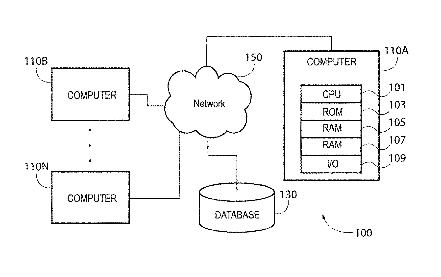
FIG. 1 depicts a diagrammatic representation of a simplified network architecture illustrating an example network environment in which embodiments disclosed herein may be implemented;
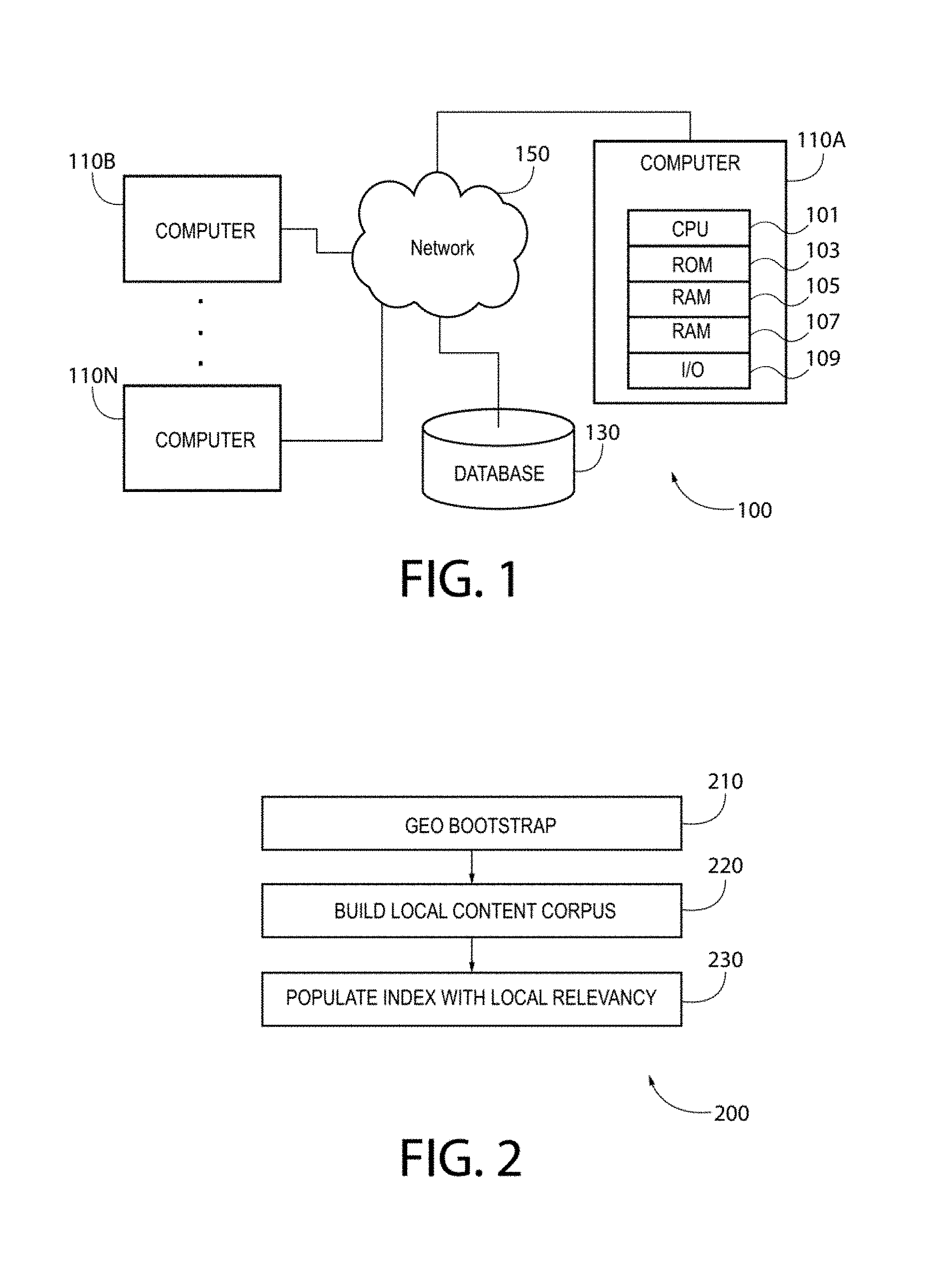
FIG. 2 illustrates an example method implementing an embodiment of a system organized into several stages of information acquisition and processing, with each stage focusing on filtering or qualifying content based on geographic information;
FIG. 3 depicts a diagrammatic representation of one example embodiment of a system architecture;
FIG. 4 depicts a diagrammatic representation of an example geographic hierarchy;
FIG. 5A depicts a diagrammatic representation of one embodiment of a local hierarchy;
FIG. 5B depicts an example of a local hierarchy that captures an neighborhood located in Austin, Tex.;
FIG. 6 illustrates an example of how each document being processed is mapped to corresponding local entity weightings;
FIG. 7 depicts an example distributed architecture where an instance of an indexing engine can be shared across an entire system architecture;
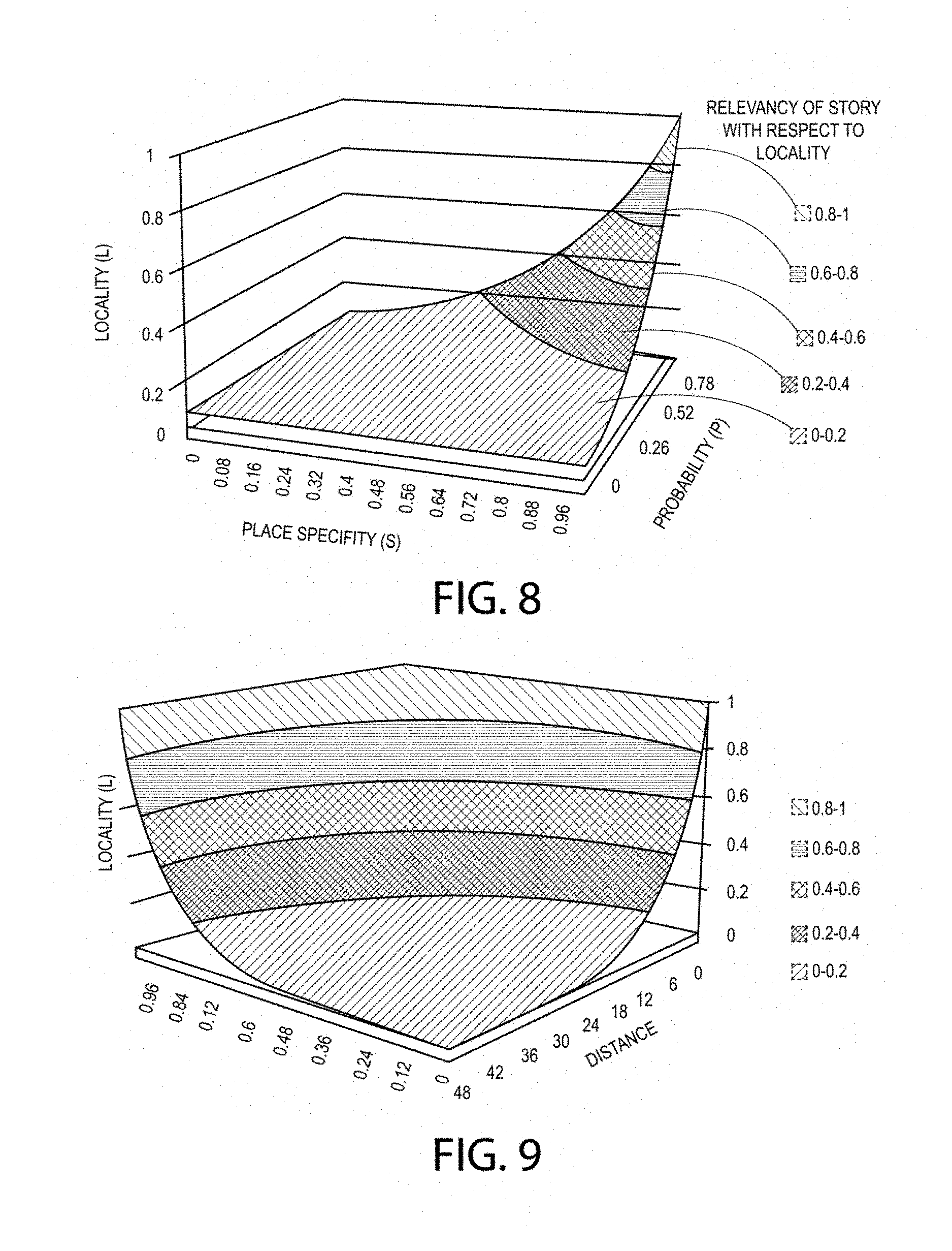
FIG. 8 depicts an example plot diagram showing values representing the specificity of a place S relative to the probability P that a story is in a given place or locale L as determined by local entity weightings;
FIG. 9 depicts an example plot diagram showing values representing the distance as compared to the product of S and P for data with both hard and soft geocoding;
FIG. 10 depicts a diagrammatic representation of post-indexing stages for polling, curating, and editing content in a local content corpus;
FIG. 11 depicts a diagrammatic representation of an example crawler architecture;
FIG. 12 depicts a diagrammatic representation of an example content ranking and classification process;
FIG. 13 depicts a diagrammatic representation of an example of a supervised learning process;
FIG. 14 depicts a diagrammatic representation of an example user interface of a network site implementing an embodiment of the system disclosed herein;
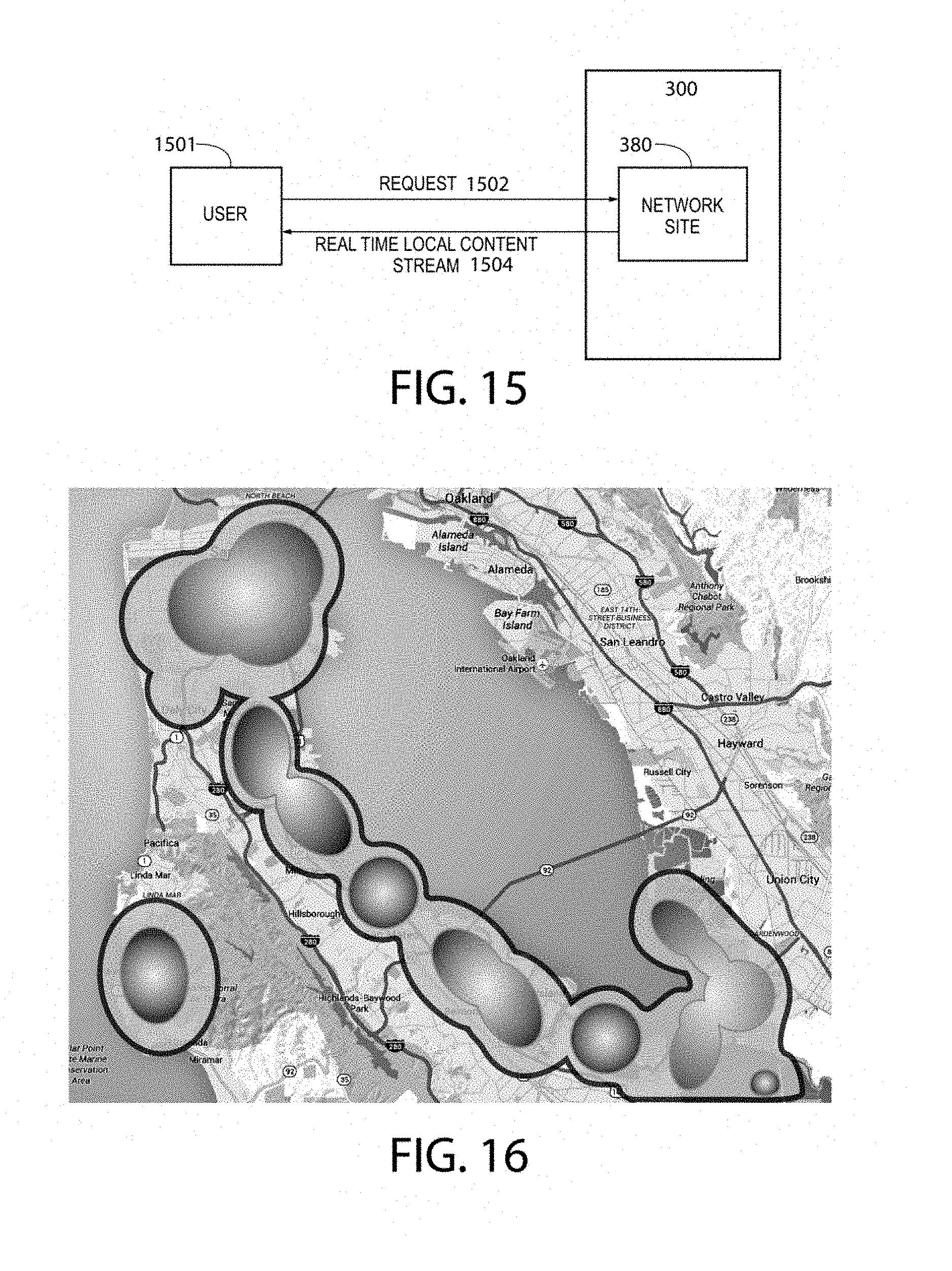
FIG. 15 a diagrammatic representation of a network communication between a user device and the network site, the system providing a user through the network site local content highly relevant to a place and/or subject of interest to the user; and
FIG. 16 depicts a "thermal" image showing the most relevant news articles relative to a place.
DETAILED DESCRIPTION
The disclosure and various features and advantageous details thereof are explained more fully with reference to the exemplary, and therefore non-limiting, embodiments illustrated in the accompanying drawings and detailed in the following description. It should be understood, however, that the detailed description and the specific examples, while indicating the preferred embodiments, are given by way of illustration only and not by way of limitation. Descriptions of known programming techniques, computer software, hardware, operating platforms and protocols may be omitted so as not to unnecessarily obscure the disclosure in detail. Various substitutions, modifications, additions and/or rearrangements within the spirit and/or scope of the underlying inventive concept will become apparent to those skilled in the art from this disclosure.
Software implementing embodiments disclosed herein may be implemented in suitable computer-executable instructions that may reside on a computer-readable storage medium. Within this disclosure, the term "computer-readable storage medium" encompasses all types of data storage medium that can be read by a processor. Examples of computer-readable storage media can include, but are not limited to, volatile and non-volatile computer memories and storage devices such as random access memories, read-only memories, hard drives, data cartridges, direct access storage device arrays, magnetic tapes, floppy diskettes, flash memory drives, optical data storage devices, compact-disc read-only memories, and other appropriate computer memories and data storage devices.
Before discussing embodiments of invention, a hardware architecture where embodiments disclosed herein can be implemented is described with reference to FIG. 1. In FIG. 1, network computing environment 100 may comprise network 150. Network 150 can represent a private network, a public network, or a virtual private network (VPN). A company's intranet might be an example of a private network and the Internet might be an example of a public network. A VPN uses primarily public telecommunication infrastructure, such as the Internet, to provide remote users with a way to access an internal network of an organization or entity. Various types of networks are known to those skilled in the art and thus are not further describe Network 150 can be bi-directionally coupled to a variety of networked systems, devices, repositories, etc.
In the simplified configuration shown in FIG. 1, network 150 comprises a plurality of computers and/or machines 110A-N. Computers 110A-N may comprise at least a server machine and a client machine. Virtually any piece of hardware or electronic device capable of running client software and communicating with a server can be considered a client machine. As en example, computer 110A may include a central processing unit (CPU) 101, read-only memory (ROM) 103, random access memory (RAM) 105, hard drive (HD) or non-volatile memory 107, and input/output (I/O) device(s) 109. An I/O device may be a keyboard, monitor, printer, electronic pointing device (e.g., a mouse, trackball, touch pad, etc.), or the like. The hardware configuration of computer 110A can be representative to other devices and computers alike coupled to network 150 (e.g., desktop computers, laptop computers, personal digital assistants, handheld computers, cellular phones, and any electronic devices capable of storing and processing information and network communication). Computer 110B may implement an embodiment of a system disclosed herein and may connect to database 130 and computer 110A via network 150. In some embodiments, database 130 may be accessible by computer 110B locally. For example, database 130 and computer 110B may reside on a private network or a company's intranet. Database 130 may store data used by the system in computing environment 100. In some embodiments, database 130 may reside on computer 110B. In some embodiments, computer 110B may send information to computer 110A over network 150 and computer 110A may operate to present the information to a user of computer 110A.
As one skilled in the art can appreciate, the exemplary architecture shown and described herein with respect to FIG. 1 is meant to be illustrative and not limiting. Further, embodiments disclosed herein may comprise suitable software including computer-executable instructions. As one skilled in the art can appreciate, a computer program product implementing an embodiment disclosed herein may comprise one or more non-transitory computer readable storage media storing computer instructions translatable by one or more processors in computing environment 100. Examples of computer readable media may include, but are not limited to, volatile and non-volatile computer memories and storage devices such as ROM, RAM, HD, direct access storage device arrays, magnetic tapes, floppy diskettes, optical storage devices, etc. In an illustrative embodiment, some or all of the software components may reside on a single computer or on any combination of separate computers.
As discussed above, using the IP geo-locating methodology, online local content can better compete against the entire body of content available on the Internet, but users still have to "guess" the best search terms when attempting to find local data and the data is presented as a long list of disconnected items. Also, due to the low resolution of IP geo-locating, current geographic search results tend to include only city level qualified content, which makes neighborhood or address level search based on a user's current IP address impossible outside the realm of mobile devices.
Today, to discover local information a search user continues to be confronted with guessing appropriate search terms for a given locality. This is a key usability problem. Users need to know an area before they can guess good search terms for that area. However, users cannot get to know an area without knowing good terms. Guided content discovery can help users bridge this search term gap by using their geographical affiliation to deliver edited content about the area of interest, which enables efficient local content discovery.
For the perspective of local content provider, however, this presents another problem. Search engine optimization (SEO) is the process of improving the visibility of a website or a web page in search engines via the "natural" or un-paid ("organic" or "algorithmic") search results. Savvy content providers and publishers alike often attempt to organize their content in a way that influences the ranking in search engine results. For example, they may embed keywords and links in their content to drive up their content's relative ranking within search engine results. Competition for ranking has become highly specialized beyond the level of sophistication for most local content providers.
Recognizing the intrinsic need for local content, embodiments disclosed herein provide a system for automated discovering, curating, and editing local content. The system can enable local content publishers to better reach local content consumers. Additionally, local content can be provided in context with other local content to facilitate user information discovery.
In some embodiments, the system can be organized into several stages of information acquisition and processing, with each stage focusing on filtering or qualifying content based on geographic information. FIG. 2 illustrates an example method 200 implementing an embodiment of the system comprising first stage 210, second stage 220, and third stage 230. As will be described in further detail below, method 200 may comprise, bootstrapping an initial set of terms for a place at first stage 210, building a local content corpus for the place at second stage 220 utilizing the initial set of terms for the place from first stage 210, and populating an index at third stage 230 with information from the documents in the local content corpus.
Within this disclosure, a place can be any named area where a user has a primary affiliation. For example, for cities a named area can be a neighborhood; whereas, for small towns, a named area can be a town or municipality itself. In order classify content relative to place, in some embodiments, the system can be built to enable near constant time classification of content. As will be further described below, this approach can be based on a local entity weighting approach for content classification.
The system allows self-edited content to be created from general content templates based on web crawling and machine learning algorithms. These content templates are based on likely interest areas and can be customized by the end-user. In this context, "self" refers to the system. Editing is the process of reviewing and then condensing, correcting or arranging written material, images, sound, video, or film with the objective of preparing it for final presentation. As an editor, the system uses its understanding of the audience to determine the best content for publication. The system approximates, simulates, and automates the editing process by discovering who publishes content locally, what is locally interesting to the local audience then generating, on an ongoing basis, streams of content based on the learned place interest.
The system also finds the relationships amongst data based on learning and/or finding common patterns of information in the content. The relationships amongst data enable content tapestries to be created which, in turn, enables a user to see content in its local context.
At this point, a few observations can be made: Local content is local because of the "subjects" of the content. A subject of the content is a function of the entities (associated terms) that make up that content. Local content is anchored around local people, places and things of interest. These subjects of interest tend to relatively constant and mainly oriented around local geography. Examples of local places of interest may include, but are not limited to: Local businesses, schools, parks, streets, churches, etc. Content that contains references to these features can be locally relevant and the content from an area tends to have references to other local subjects and links to other web pages with local subjects. Given a large metropolitan area, the amount of content created within that given locality can be proportional to the density of the population. Web content publication continues to grow rapidly. Features that anchor content establish the place affinity for a given location. Place affinity can vary broadly due to depending social, urban planning and historical. The relevancy of local content can vary exponentially with the distance to the audience. For example, crime information can be extremely relevant in a 0.25-mile radius versus crime information about 5 miles away. Local content by its nature can become uninteresting outside its immediate local context. Local content can be boundary sensitive in that boundaries of neighborhoods and places can play as an important role to content relevancy as the distance proximity. Local content sources publish on irregular basis due to that fact the blogs and tweets about the local area are often done by authors as a side-hobby. Trying to base a content stream on any single source will not provide a regular enough content stream to be compelling for the user.
In some embodiments, the system may leverage enabling technologies. One example may be keyword search implementing a search algorithm. In computer science, a search algorithm, broadly speaking, is an algorithm for finding an item with specified properties among a collection of items. Another example may be geotagging. Geotagging is the process of adding geographical identification metadata to various media such as photographs, video, websites, SMS messages, or RSS feeds (described below) and is a form of geospatial metadata. This data usually consist of latitude and longitude coordinates, though they can also include altitude, bearing, distance, accuracy data, and place names. Geotagging is commonly used for photographs, giving geotagged photographs. The amount of geotagged data is growing due to the adoption of personal mobile devices.
In some embodiments, the system may leverage known standards, including Internet publication standards which have emerged to enable easy interchange of content between parties. One example is RSS (most commonly expanded as Really Simple Syndication) which is a family of web feed formats used to publish frequently updated works--such as blog entries, news headlines, audio, and video--in a standardized format. An RSS document (which can be called a "feed", "web feed", or "channel") includes full or summarized text, plus metadata such as publishing dates and authorship. Web feeds benefit publishers by letting them syndicate content automatically. They benefit readers who want to subscribe to timely updates from favored websites or to aggregate feeds from many sites into one place. RSS feeds can be read using software called an "RSS reader", "feed reader", or "aggregator", which can be web-based, desktop-based, or mobile-device-based. A standardized XML file format allows the information to be published once and viewed by many different programs. The user subscribes to a feed by entering into the reader the feed's URI or by clicking a feed icon in a web browser that initiates the subscription process.
In some embodiments, the system utilizes an indexing engine to build and index all the local content. Features of this indexing engine may include powerful full-text search, hit highlighting, faceted search, dynamic clustering, database integration, and rich document (e.g., Word, PDF, etc.) handling. Enabled by the indexing engine's distributed search and index replication functionality, the system can be highly scalable and can support virtually unlimited content queries.
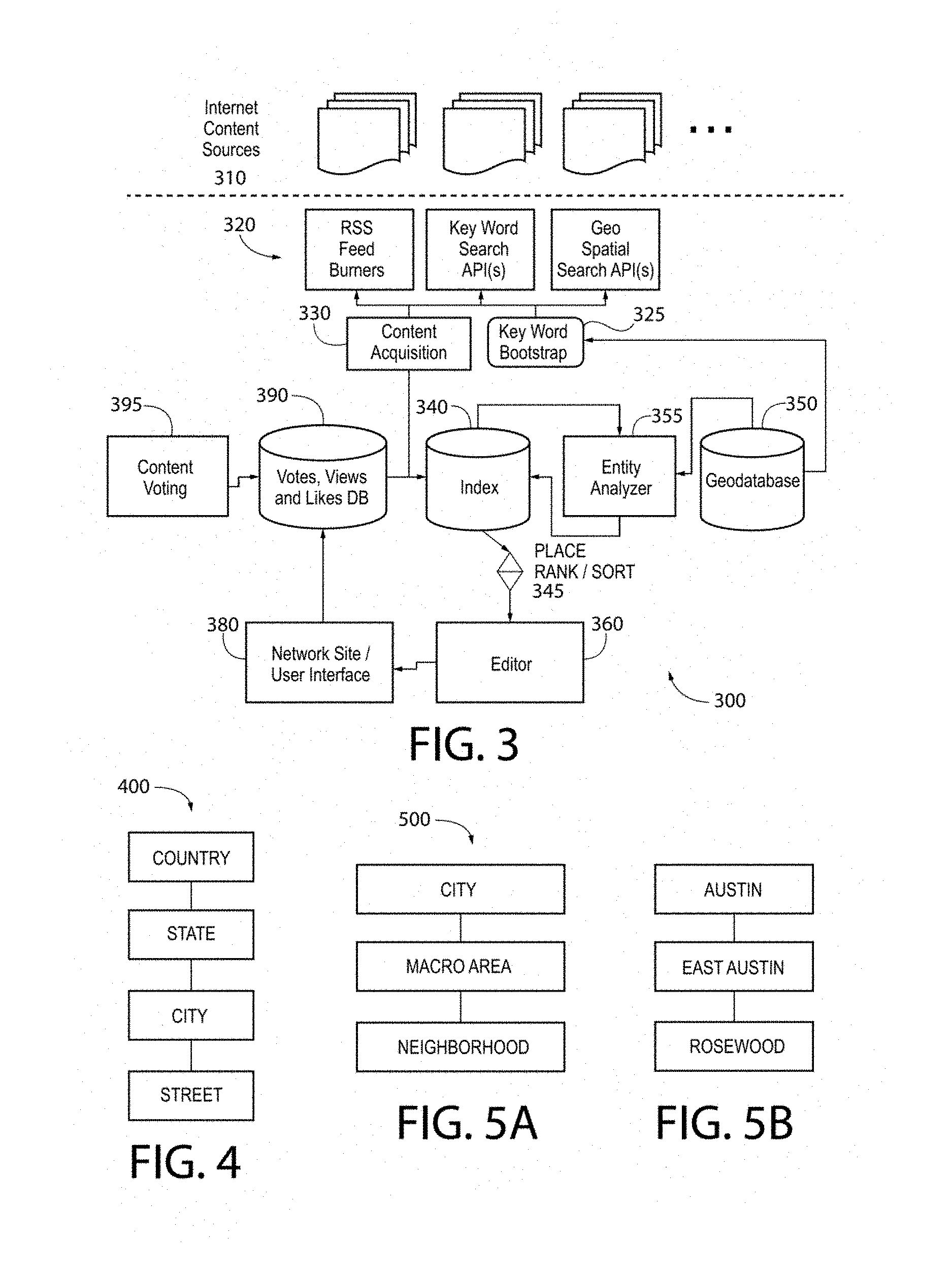
FIG. 3 depicts a diagrammatic representation of one example embodiment of a system architecture showing ail the services required by the system. Each service in system 300 can be run as a stand-alone entity or as a separate process connecting through networked inter-process communication. Services in system 300 can be communicatively connected to Internet content sources 310 via application programming interfaces (APIs) 320. Content acquisition 330 and key word bootstrap 325 may operate on various contents obtained from Internet content sources 310 through APIs 320.
In one embodiment, key word bootstrap 325 may be configured to perform bootstrapping an initial set of terms for a place at first stage 210. Given any populated area, there exists a set of well-known geographic places. By using a geographic database (also referred to herein as a geodatabase), key word bootstrap 325 can automatically create a set of keyword search terms.
A geodatabase is a database designed to store, query, and manipulate geographic information and spatial data of low dimensionality. Within a spatial database, spatial data is treated as any other data type. Local entity weighting data can be stored and associated with geo point, line or polygon data types, and may have an associated spatial reference system. One primary advantage of spatial databases, over file-based data storage, is that a geographic information system (GIS) can be built on the existing capabilities of relational database management systems (RDBMS). This gives an otherwise standard database an ability to retrieve geospatial query terms and includes support for SQL and the ability to generate complex geospatial queries. Also, a database's client/server architecture supports multiple users simultaneously and lets them view, edit, and query the database without conflict.
A geodatabase record can use a geometry data type to represent the location of an object in the physical world and other standard database data types to store the object's associated attributes.
As an example, geodatabase 350 may contain state, municipality, macro area and neighborhood name data. Note, however, geography boundaries are not limited to any set of real-state boundaries. Boundaries can include any affiliation that exists as a function of user location. These boundaries include school districts, political, municipal zoning, etc. By leveraging these key word search terms based on key words based on boundaries and their name hierarchy and geo-spatial queries based on boundary polygons an initial content data stream to be created for a given set of boundaries.
In one embodiment, geodatabase 350 may hold a set of all geo-spatial polygons associated with places. This database also contains a place hierarchy. In one embodiment, geographic places can be arranged in the place hierarchy where each level represents a geographic level. For example, a U.S. address can be represented to reflect a geographic hierarchy for the purpose of efficient postal routing. More specifically, suppose a U.S. address is as follows: 1813 Clifford Ave Austin, Tex. 78702 U.S.A.
The address starts with the street, which is the lowest level of a geographic hierarchy, followed by the city then the state and then the country. Oriented in a parent-to-child order the address would read: U.S.A., TX, Austin, 1813 Clifford Ave
FIG. 4 depicts general hierarchy 400 representing this hierarchy as graph. This hierarchy represents a geographical containment hierarchy, where each level of the hierarchy contains the subsequent contained or child levels. These hierarchies are strictly partitioned where no geographic place overlaps any other within the same level of the hierarchy within a boundary class (real-estate, school district, city-political).
Local geographies decompose further into areas oriented around neighborhoods in most metropolitan areas. These local geographies are mainly a function of real-estate boundaries and socio-economic factors that partition populations within cities. As such, this hierarchy encodes important social context that enable a reasonably targeted automated key word search to prime content acquisition. FIG. 5A depicts local hierarchy 500 and FIG. 5B depicts an example of local hierarchy 500 that captures a neighborhood located in Austin, Tex.
This hierarchy further qualifies where Rosewood neighborhood resides by providing the macro area, "East Side" as its parent. "East Side" refers to a section of Austin that is distinct from other sections of Austin.
In many cities, this macro-level decomposition reflects the compass directional (North, South East, West, etc.). However, many cities may have districts that exist due to real-estate development or area history.
The system can therefore be organized around places, each representing a named area where a user has a primary affiliation. For cities this can be the neighborhood and for small towns this can be the town or municipality itself. Place affiliation can be a key to enabling effective content acquisition. When a user provides the system with their address, the user is implicitly providing a rich context for the system to base automated content acquisition. In some embodiments, these places groups can be defined by local boundaries below the city level. The system can be designed to operate best in the most specific local context.
Currently, there is not a 100% reliable source for local boundaries (i.e., boundaries below the city level). In order to drive content acquisition efficacy, the system can be connected with local information sources to compile local boundary information for areas where the system is deployed.
In one embodiment, by applying the following algorithm an initial set of "bootstrap" content can be generated. The content is referred to as "bootstrap" as it requires no a priori knowledge of an area, other than local geographic hierarchy.
EXAMPLE Geo-place key word generation algorithm: .A-inverted.(.rho.): .rho. is a place group (.rho. place groups below the city level) visit (.rho.) let keyword search terms= concat(name(.rho.), name(macro(.rho.)), name(city(.rho.)) where .rho. is a place group in the geo hierarchy where visit traversal through the geo-hierarchy to .rho. with .rho.: (attributes of v: name level parent, children) where concat (a.sub.0, a.sub.1 . . . a.sub.n)string concatenation of a.sub.0, a.sub.1 . . . a.sub.n where macro(.rho.)the macro area group containing .rho. where city(.rho.)the city or municipality group containing .rho.
With this initial set of local search terms, a set of keyword searches can be generated automatically for any place. These initial terms enable a bootstrap content stream to be created for any given place where the system is deployed.
Key word searches based on this algorithm enable an initial set of priming content (or corpus) to be created for the system (e.g., at stage 220). This priming content establishes the initial body of content that the system will use to begin to baseline content relevancy. The system leverages Bayesian probability that local content for a place will have local entities with a higher relative probability.
To generate a local corpus, the system first generates local content streams from each of the top-level content data sources and aggregators using the bootstrap keyword search terms. Place-based keyword search and geo-spatial search based on local boundaries allow the system to build up, for each place in the system, a body of content relative to the place (place corpus).
This place corpus provides the system with an importance of "local terms" (local entities) associated with a given place relative to the entire body outside a given local area. This importance can be determined using TFIDF (term frequency-inverse document frequency) weighting. The TFIDF weight is a statistical measure used to evaluate how important a word is to a document in a collection or corpus and can be used in information retrieval and text mining. The importance increases proportionally to the number of times a word appears in the document, but is offset by the frequency of the word in the corpus. One example of TFIDF weighting algorithm is as follows:
.A-inverted.(.rho.): .rho. is a place group (.rho. place groups below the city level)
.A-inverted.(cs): (cs: content source providing key word search) let content stream of .rho.=keyword search (cs, keywords of .rho.) .A-inverted.(t): (t: term in content stream--(st: stop words))
.times..times..function..times. ##EQU00001## with |D|: cardinality of D, or the total number of documents in the place corpus |{d:t.sub.i d}|: number of documents where the term t.sub.i appears (that is n.sub.i,j.noteq.0). If the term is not in the corpus, this will lead to a division-by-zero. It is therefore common to use 1+|{d:t.sub.i d}| Then (tf-idf).sub.i,j=tf.sub.i,j.times.idf.sub.i where .rho. is a place group in the geo hierarchy.
In order to classify content relative to place, the system enables near constant time O(1) automated classification of content. This approach is based on a local entity weighting model approach for content classification. In system 300, this is implemented in entity analyzer 355.
Document classification/categorization is a general problem in information science. The task is to assign an electronic document to one or more categories, based on its contents. Document classification tasks can be divided into two sorts: supervised document classification where some external mechanism (such as human feedback) provides information on the correct classification for documents, and unsupervised document classification, where the classification must be done entirely without reference to external information. There is also a semi-supervised document classification, where parts of the documents are labeled toy the external mechanism. In one embodiment, the system is supervised and semi-supervised where content is tagged by both internal content voting, external input from users and existing reference tagged corpus for named entity recognition.
One example of a local entity weighting model may be a vector space model (or term vector model), which is an algebraic model for representing text documents (and any objects, in general) as vectors of identifiers, such as, for example, index terms. It is used in information filtering, information retrieval, indexing and relevancy rankings. In this case, documents (dj) and queries (q) are represented as vectors with entity weights (w1 . . . t). dj=(w1,j,w2,j, . . . , wt,j) q=(w1,q,w2,q, . . . , wt,q)
Each vector corresponds to a separate term. If a term occurs in the document, its value in the vector is non-zero. The entity weights are established through TFIDF weighting. In one example, the system defines local entities as people, places and things found in local content using named entity recognition.
Vectorization can enable the system to highly compress and index the entire history of all content seen in (or associated) with a place by representing the history of content as a single large vector. This vector is updated as new content is discovered for or associated with a place and as product management selectively classifies sample documents by pre-defined classification.
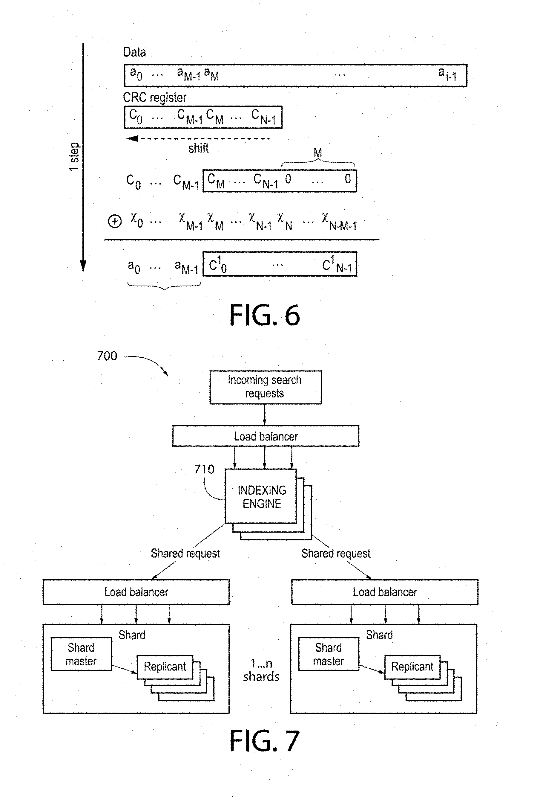
Each document that the system processes is mapped to a corresponding document vector by computing the CRC (cyclical redundancy check), one example of which is illustrated in FIG. 6.
As illustrated in FIG. 6, the CRC computation resembles a polynomial long division operation in which the quotient is discarded and the remainder becomes the result, with the important distinction that the polynomial coefficients are calculated according to the carry-less arithmetic of a finite field. A CRC for a given string of characters has a high probability for being unique within a given sequence of bits. Using the CRC allows the system to create a hash that is unique for each term and map that hash into the term vector. The goal of using the hash is to insure that term vectors are both unique and highly orthogonal. An example vectorization algorithm is as follows: .SIGMA..sub.vec term vectors in a document: .A-inverted.(.tau.): .tau. is a people, place, thing term in a document let term crc=CRC (.tau.) from above let term vector=crc=>unique term vector
These term vectors can then be plugged into a content history algorithm for a given document class to find the vector sum of all document vectors seen in that place: .A-inverted.(class): class is content category .SIGMA..sub.vec,class: term vectors for a place .A-inverted.(.tau.): .tau. is a people, place, thing term in a document let term crc=CRC(.tau.) let term vector=crc=>term vector
To compute whether a document is similar to documents of a given class of documents within a place, the system computes the cosine similarity between a document and that given class.
.function..times..times..times..times. ##EQU00002##
Those documents with higher cosine similarities computed against a place's term history are mathematically more relevant to that place than those documents with lower scores within document classes.
In addition to the vectorization approach described above, other types of local entity weighting models may also be used.
Now that the system has local content corpora (each representing a body of content that is local to a place), the system uses an indexing engine to build and index all the local content. One example indexing engine is Elastic Search, a distributed open source search server that supports the near real-time search of Apache Lucene. Elastic Search can index data using JavaScript Object Notation {JSON} over HyperText Transport Protocol (HTTP).
JSON is a text format that is completely language independent but uses conventions that are familiar to programmers of the C-family of languages, including C, C++, C#, Java, JavaScript, Perl, Python, and many others, Provide an index name, a type and an identifier of a typed JSON document to Elastic Search and it will automatically perform indexing using a unique identifier at the type level and return the actual JSON document used to index the specific data. Each index in index database 340 can have its own settings which can override the master settings. One index can be configured with a particular memory storage and have multiple (1 . . . n) shards with 1 replica each, and another index can have a file based storage with 1 shard and multiple replicas. All the index level settings can be controlled when creating an index using a JSON format.
Other suitable distributed search and index platforms may also be used, for example, Apache Solr, which is an open source enterprise search platform from the Apache Lucene project. The system therefore can leverage features of Apache Lucene which include powerful full-text search, hit highlighting, faceted search, dynamic clustering, database integration, and rich document (e.g., Word, PDF) handling. Both Elastic Search and Solr architectures enable "wide-scaling" of the indexing system to support virtually unlimited content queries. As illustrated in FIG. 7, system 700 can deploy an instance of indexing engine 710 that is shared across the entire system architecture.
These indexing engines enable the system to implement a customized neighborhood content ranking algorithm that determines the relevancy of documents contained in the index relative to a geo place.
To reflect use bias to most local content, the system may implement a rank-boosting algorithm based on content geotagging. Only a small percentage (e.g., .about.5%) of content found on the Internet is "hard tagged" with an originating location encoded as latitude and longitude using the standard geo microformats. Due to the low occurrence of hard geotagging, local boosting is a function of both local relevancy score by document classification and geotag data when available. This allows content to be soft geotagged by using the local entity weighting classifier when no geotag is available for the content.
The boosting algorithm can be integrated into the indexing engine by implementing a custom ranking query, one example of which is as follows:
P=probability that a story is in a given place, as determined by local entity weighting, where 0<=P<=1
S=specificity of the place (low for large areas, high for small areas) where 0<=S<=1
Thus, 0<=SP<=1 and SP gives us a measure of how likely it is that the story is locally relevant.
The bigger SP is, the more locally relevant the story is likely to be. The ranking function must work with hard geotagged data when soft geotagged data is not present. This gives the soft geotagged data equal footing with the hard geocoding, which is useful since all pages will have soft geotagged data while only a small percent will have hard geotagged data.
If there is no hard geotagged data, let L=0.25 (arbitrary). Otherwise, use previously calculated value of L: L=L^[2*(1-SP)]
FIG. 8 depicts an example plot diagram showing values of S and P on the x- and y-axes and values of L on the z-axis. This is for items with no hard geotagged data (so L starts with the base value of 0.1). It can be seen that the system only gets a high value for L If both P and S are high (that is, if the story has a high probability of being in a small region containing the user's neighborhood). If SP<0.5 then L is raised to a power greater than 1 which makes its value smaller. This way, if SP>0.5, it boosts the locality, if SP<0.5, it makes the locality smaller, and if SP=0.5 then the locality is unchanged.
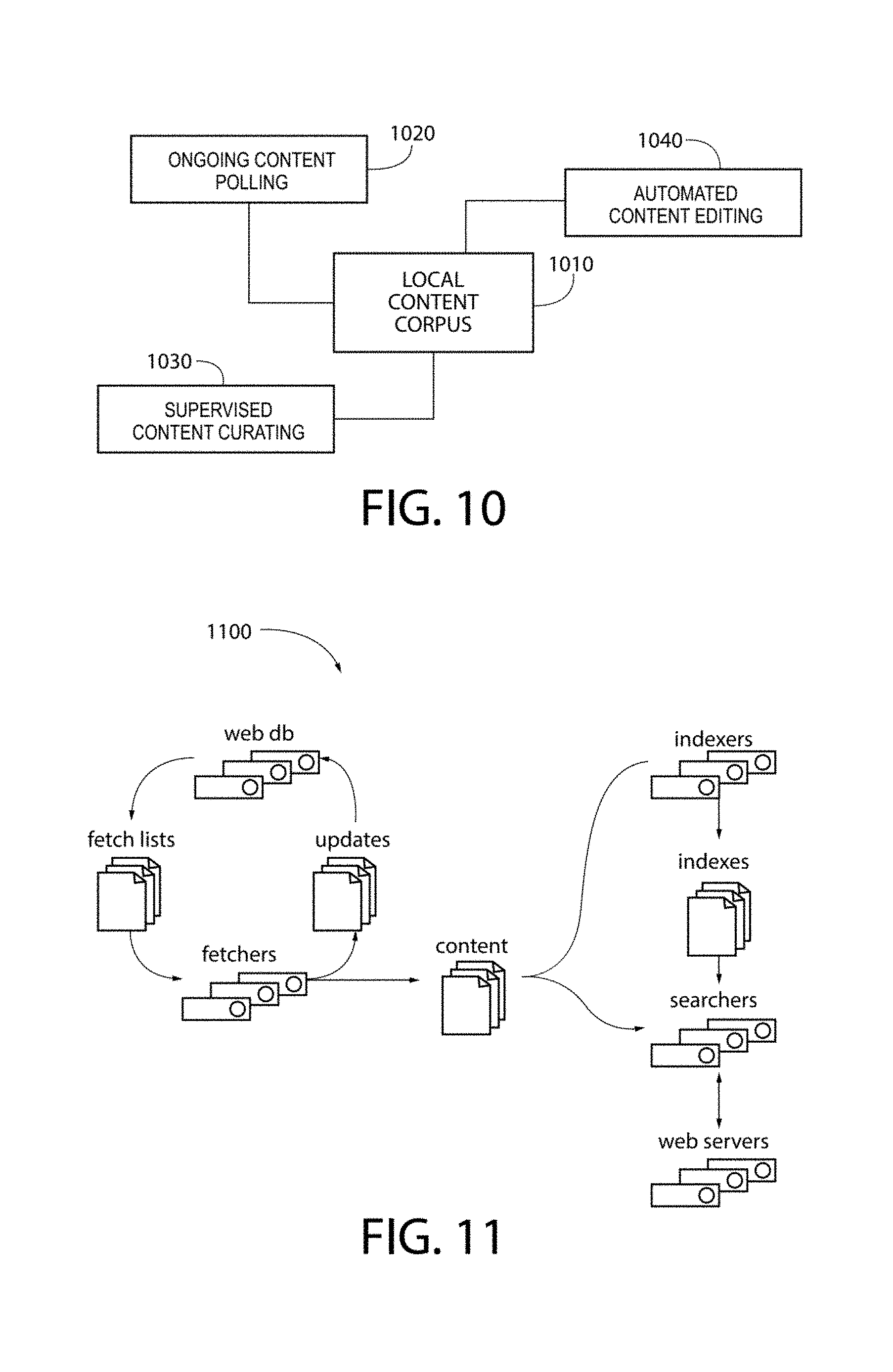
FIG. 9 shows the distance as compared to the product of S and P for data with both hard and soft geocoding. The z-axis is the value of locality L.
The effect of applying this exponential boosting is creating shelves of very local data around places, making content very near to the user boosted with higher relevancy and data from external neighborhoods to be driven down the rank, effectively being excluded or filtered from the results. This allows strict partitioning of local data along the place hierarchy. A key aspect of geo places ranking is to rank content based on both Euclidian distance and whether the content is pinned inside a place boundary.
A namespace may be utilized to represent a place boundary. A namespace is an abstract container or environment created to hold a logical grouping of unique identifiers or symbols (i.e., names). Neighborhood names can have a crowded namespace due to their frequent re-use from locality to locality. This neighborhood name collision, when ranking content can be addressed by negating search results using a custom query capability (configured for a suitable indexing engine of choice such as Elastic Search or Solr). Search results from the content index are negated when references to outside localities are encountered in the content.
As an example, Hyde Park refers to a place in Chicago, England, and Austin, Tex. The local content index allows search results to be filtered by applying Boolean negation to additional place references within the contents body. By combining geodatabase information and the content index, searches can be easily pruned for less relevant content by applying stop words (search filters) implicitly for queries within a locality.
A sample custom search query from the system to an Elastic Search indexing engine is as follows:
http://search.loku.com/news?type=feed-item%2Cdeal%2Cevent%2Cvideo%2Cbusin- ess&take=20%2C5%2C5%2C3%2C5&broaden&geo=30.4212235%2C-97.99917959999999%2C- 30.1128403%2C-97.486942&sliders=%7B%22Local%22%3A.5%2C%22Foodie%22%3A0.5%2- C%22Hipster%22%3A0.5%2C%22Flirty%22%3A0.5%2C%22Swanky%22%3A0.5%2C%22Worldl- y%22%3A0.5%7D&&callback=jQuery16404248902138788253_1332133013217&_=1332133- 013421
Output from the indexing engine in response to this sample search query is provided in Appendix A attached to this application.
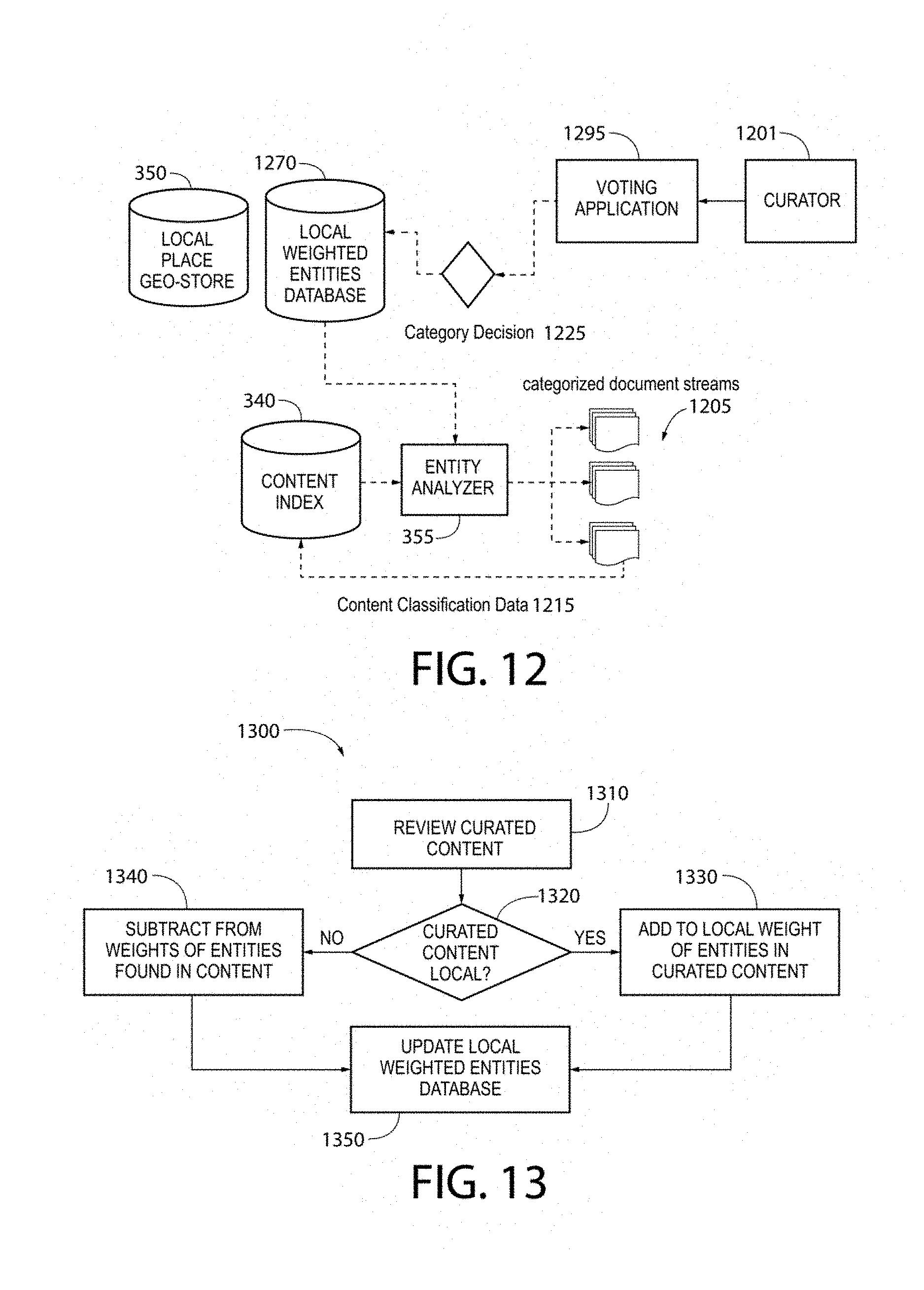
With a content index in place and an initial base line of local entity weights by place, the system can enable targeted web crawling for additional local content. This can be done at a stage that is separate or in conjunction with other stages (also referred to as post-indexing stages). As illustrated in FIGS. 2, 3, and 10, a crawler (e.g., content acquisition 330) may be configured to continuously acquire content from Internet content sources 310 at stage 1020, The system may process the acquired content as described above and fine tune local content corpus 1010. Index 340 can be updated to include additional content with local relevancy with respect to local content corpus 1010. As will be described further below, the system may also conduct supervised and/or semi-supervised content curation for local content corpus 1010 at stage 1030 and self-edit content in local content corpus 1010 at stage 1040.
To enable the ongoing content polling at stage 1020, in one embodiment, the system utilizes an open source crawler such as Nutch. FIG. 11 depicts a diagrammatic representation of an example Nutch architecture. In one embodiment, crawler 1100 can provide the underlying system platform with the following capabilities: Highly scalable and relatively feature rich crawler. Features like politeness which obeys robots.txt rules, Robust and scalable--the system can run this crawler on a cluster of 100 machines. Quality as the system can bias the crawling to fetch "important" pages first.
The crawler can enable the system to crawl links from local content and keyword search and score newly discovered content through local entity weighting and other customized criteria as links are crawled. This creates a targeted optimized web-crawler for every place in the system. This web crawler uses a place's "local taste" encoded in the place's entity weights to find content that place would likely find interesting.
As discussed above, the crawler can also monitor content sources on an ongoing basis to determine if there are any updates, which enables large volumes of websites to be watched on a frequent basis. Once the system finds a "good" local source of content for a place, that local source will be continuously monitored for updates and those updates are placed into the local content index (e.g., index 340), stored in the indexing engine. The crawler's continuous monitoring allows a set of frequently updated content streams to be created from a set of low frequency, infrequently published sources.
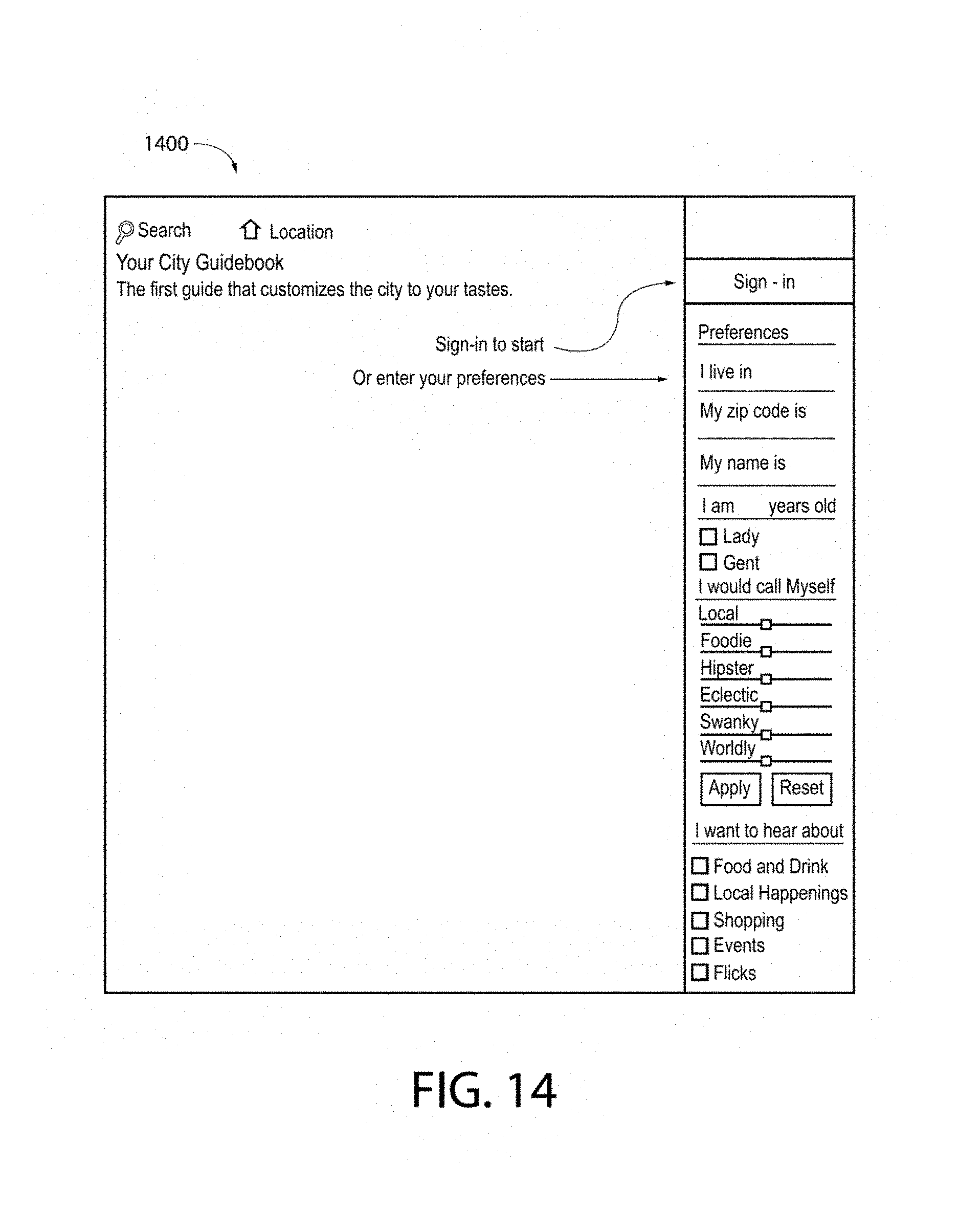
As illustrated in FIG. 12, once content is acquired and indexed, product management or team of authorized users (collectively, curator 1201) can selectively categorize content based on target content categories, utilizing voting application 1295. These categorization votes (category decisions 1225) can be stored in databases 350, 1270 and factored in a post-processing process (not shown). Curator 1201 can vote on a current place's publication and the top of local content index 340 for a given place.
As an example, classifications may include neighborly (content reflecting `local flavor`), spam, sports, crime and other interest related categories. Curator 1201 can add and remove categories based on editorial judgment. These classifications can be arbitrary and can be combined with one another through logical composition.
Votes can associate entity weights with a particular classification and update existing entity weights that are used to automatically classify new documents.
Further, category classification votes can be augmented based on user clicks to update the weights of each of the categories. For example and also referring to FIG. 3, if a user clicks through a categorised content item (via any one of categorized document streams 1205) based on category and does not page-bounce from that item, this viewing (content voting 395) can ascribe a weighted acceptance of a content's categorization. This value (content classification data 1215) is weighted due to the uncertainty in the information the viewing ascribes. Votes, views, and "likes" may be stored in database 390 accessible by the indexing engine described above.
Over time, as the system runs and more clicks and more votes are collected the categories and entity weight histories capture the place relative categorization. These categories are place-relative due to the fact the entity weights vary from place-to-place and reflect a place's tendency to contain local entities. With these entity weights in place, any content can be scored for "place affinity" for any place in the system.
Using with the local content index and automated content categorization based on local entity weighting, an automated editing process can be created. FIG. 13 depicts a diagrammatic representation of an example of a supervised learning process which draws from content in the index based on editing targets and optimizing based on "best available" content and content mixes. As an example and also referring to FIG. 3, automated editing function or editor 360 may operate to review a curated piece of content (step 1310), perhaps with place ranking data 345, and determine whether that content is local to a certain place (step 1320). If so, the system may add to the local weight of entities in the curated content (step 1330). If not, the system may subtract from the weights of entities found in the curated document (step 1340). Database 1270 is then updated to reflect any adjustment made to the local weighted entities (step 1350).
Content mixes can enable editing targets to reflect available content. This can be useful with respect to density in various places. For example, urban centers often have a high amount of social content like Twitter and there are large numbers of places of interest, which anchor content streams. By contrast, suburban communities have sparser content streams driven by occasional posts from fixed content sources. An optimization goal for the automated editor is to drive regular updates to each content stream as available content allows.
In one embodiment, an automated editing process pulls from the content index and applies a customized collection algorithm based on content mix type. The collection algorithm pulls from the index creating a rotation of content based on geographic and content categories. An example editing algorithm is provided below: Set the editing target of 10 articles, with a mix of interest types not over representing a content source within the stream. Let filled (publication): (true, false) where true when meeting content targets, by category, source attenuation, content type adjacency and length of overall publication .A-inverted.(.rho.): .rho. is a place group (.rho. place groups with active users) while not filled (publication) .A-inverted.(level): {1 (neighborhood(p), macro(p), city(p))} pull from local content index (level(p)) apply editing targets, trimming (publication), push onto discard-queue re-check editing targets pulling from local content parent (level(p))
The editing algorithm climbs the place hierarchy to meet content targets. This allows the system to optimize for the most local relevant content available by each of the content categories. Other suitable editing algorithms may also be implemented.
The system's knowledge increases with each pass of process 1300, strengthening the system's ability to dynamically rank local content that is highly relevant to a particular place and/or local favor. Each place added in the geodatabase may also increase the system's ability to further distinguish local entities.
FIG. 14 depicts a diagrammatic representation of as example user interface (UI) of a network site implementing an embodiment of the system disclosed herein. FIG. 15 a diagrammatic representation of a network communication between a user device and the network site, the system providing a user through the network site local content highly relevant to a place and/or subject of interest to the user. Referring to FIGS. 3, 14, and 15, UI 1400 may provide user 1501 with access to network site 380. In response to a request about a particular place, system 300 may form a query to index 340. In the example of FIG. 15, request 1502 is sent from a client device connected to system 300 which may have one or more server machines.
As a specific example, in causing request 1502 to be sent, user 1501 may not need to proactively do anything other than opening an application. If user 1501 is using a mobile device, this may be as simple as opening a mobile app. The mobile app knows the location through internal GPS and time. The mobile app may comprise client software of system 300, the client software capable of forming a query to search index 340 that essentially asks: "What is the most local place to eat or piece of news content at this time and place." An example input (in JSON) to the search index is as follows:
{document:<body text>//extracted to include only the body of article
pins: [(lat, lng), (lat, lng), (lat, lng) . . . ]//All geolocated references in document dates: (date1, date2, date3 . . . )//All dates extracted though date parsing process entities: [ner1, ner2, ner3 . . . ])//All extracted NER from corenlp)
As this example illustrates, the input may include features extracted by the system.
In response, system 300 returns at least one stream 1504 of "most relevant" news articles and places to go at that time. Stream 1504 may be presented to the user in various ways. As a specific example, suppose the user is in the Bay Area, opening an app implementing an embodiment disclosed herein may cause a client device running the app to display stream 1504 as a "thermal" image or media showing the most relevant (white hot) news articles and places to go in the Bay Area, as illustrated in FIG. 16. Local content relevant to the Bay Area may also be presented using a pinned map with each pin representing a geographic feature which can be either a point on the map (a street corner between Bay Street and Columbus Avenue in San Francisco, Calif.) or a polygon (San Jose, Calif.). Other ways to present local content relevant to a place may also be possible.
Although the invention has been described with respect to specific embodiments thereof, these embodiments are merely illustrative, and not restrictive of the invention. The description herein of illustrated embodiments of the invention, including the description in the Abstract and Summary, is not intended to be exhaustive or to limit the invention to the precise forms disclosed herein (and in particular, the inclusion of any particular embodiment, feature or function within the Abstract or Summary is not intended to limit the scope of the invention to such embodiment, feature or function). Rather, the description is intended to describe illustrative embodiments, features and functions in order to provide a person of ordinary skill in the art context to understand the invention without limiting the invention to any particularly described embodiment, feature or function, including any such embodiment feature or function described in the Abstract or Summary. While specific embodiments of, and examples for, the invention are described herein for illustrative purposes only, various equivalent modifications are possible within the spirit and scope of the invention, as those skilled in the relevant art will recognize and appreciate. As indicated, these modifications may be made to the invention in light of the foregoing description of illustrated embodiments of the invention and are to be included within the spirit and scope of the invention. Thus, while the invention has been described herein with reference to particular embodiments thereof, a latitude of modification, various changes and substitutions are intended in the foregoing disclosures, and it will be appreciated that in some instances some features of embodiments of the invention will be employed without a corresponding use of other features without departing from the scope and spirit of the invention as set forth. Therefore, many modifications may be made to adapt a particular situation or material to the essential scope and spirit of the invention.
Reference throughout this specification to "one embodiment", "an embodiment", or "a specific embodiment" or similar terminology means that a particular feature, structure, or characteristic described in connection with the embodiment is included in at least one embodiment and may not necessarily be present in all embodiments. Thus, respective appearances of the phrases "in one embodiment", "in an embodiment", or "in a specific embodiment" or similar terminology in various places throughout this specification are not necessarily referring to the same embodiment. Furthermore, the particular features, structures, or characteristics of any particular embodiment may be combined in any suitable manner with one or more other embodiments. It is to be understood that other variations and modifications of the embodiments described and illustrated herein are possible in light of the teachings herein and are to be considered as part of the spirit and scope of the invention.
In the description herein, numerous specific details are provided, such as examples of components and/or methods, to provide a thorough understanding of embodiments of the invention. One skilled in the relevant art will recognize, however, that an embodiment may be able to be practiced without one or more of the specific details, or with other apparatus, systems, assemblies, methods, components, materials, parts, and/or the like. In other instances, well-known structures, components, systems, materials, or operations are not specifically shown or described in detail to avoid obscuring aspects of embodiments of the invention. While the invention may be illustrated by using a particular embodiment, this is not and does not limit the invention to any particular embodiment and a person of ordinary skill in the art will recognize that additional embodiments are readily understandable and are a part of this invention.
Embodiments discussed herein can be implemented in a computer communicatively coupled to a network (for example, the Internet), another computer, or in a standalone computer. As is known to those skilled in the art, a suitable computer can include a central processing unit ("CPU"), at least one read-only memory ("ROM"), at least one random access memory ("RAM"), at least one hard drive ("HD"), and one or more input/output ("I/O") device(s). The I/O devices can include a keyboard, monitor, printer, electronic pointing device (for example, mouse, trackball, stylist, touch pad, etc.), or the like.
ROM, RAM, and HD are computer memories for storing computer-executable instructions executable by the CPU or capable of being complied or interpreted to be executable by the CPU. Suitable computer-executable instructions may reside on a computer readable medium (e.g., ROM, RAM, and/or HD), hardware circuitry or the like, or any combination thereof. Within this disclosure, the term "computer readable medium" or is not limited to ROM, RAM, and HD and can include any type of data storage medium that can be read by a processor. For example, a computer-readable medium may refer to a data cartridge, a data backup magnetic tape, a floppy diskette, a flash memory drive, an optical data storage drive, a CD-ROM, ROM, RAM, HD, or the like. The processes described herein may be implemented in suitable computer-executable instructions that may reside on a computer readable medium (for example, a disk, CD-ROM, a memory, etc.). Alternatively, the computer-executable instructions may be stored as software code components on a direct access storage device array, magnetic tape, floppy diskette, optical storage device, or other appropriate computer-readable medium or storage device.
Any suitable programming language can be used to implement the routines, methods or programs of embodiments of the invention described herein, including C, C++, Java, JavaScript, HTML, or any other programming or scripting code, etc. Other software/hardware/network architectures may be used. For example, the functions of the disclosed embodiments may be implemented on one computer or shared/distributed among two or more computers in or across a network. Communications between computers implementing embodiments can be accomplished using any electronic, optical, radio frequency signals, or other suitable methods and tools of communication in compliance with known network protocols.
Different programming techniques can be employed such as procedural or object oriented. Any particular routine can execute on a single computer processing device or multiple computer processing devices, a single computer processor or multiple computer processors. Data may be stored in a single storage medium or distributed through multiple storage mediums, and may reside in a single database or multiple databases (or other data storage techniques). Although the steps, operations, or computations may be presented in a specific, order, this order may be changed in different embodiments. In some embodiments, to the extent multiple steps are shown as sequential in this specification, some combination of such steps in alternative embodiments may be performed at the same time. The sequence of operations described herein can be interrupted, suspended, or otherwise controlled by another process, such as an operating system, kernel, etc. The routines can operate in an operating system environment or as stand-alone routines. Functions, routines, methods, steps and operations described herein can be performed in hardware, software, firmware or any combination thereof.
Embodiments described herein can be implemented in the form of control logic in software or hardware or a combination of both. The control logic may be stored in an information storage medium, such as a computer-readable medium, as a plurality of instructions adapted to direct an information processing device to perform a set of steps disclosed in the various embodiments. Based on the disclosure and teachings provided herein, a person of ordinary skill in the art will appreciate other ways and/or methods to implement the invention.
It is also within the spirit and scope of the invention to implement in software programming or code an of the steps, operations, methods, routines or portions thereof described herein, where such software programming or code can be stored in a computer-readable medium and can be operated on by a processor to permit a computer to perform any of the steps, operations, methods, routines or portions thereof described herein. The invention may be implemented by using software programming or code in one or more general purpose digital computers, by using application specific integrated circuits, programmable logic devices, field programmable gate arrays, optical, chemical, biological, quantum or nanoengineered systems, components and mechanisms may be used. In general, the functions of the invention can be achieved by any means as is known in the art. For example, distributed, or networked systems, components and circuits can be used. In another example, communication or transfer (or otherwise moving from one place to another) of data may be wired, wireless, or by any other means.
A "computer-readable medium" may be any medium that can contain, store, communicate, propagate, or transport the program for use by or in connection with the instruction execution system, apparatus, system or device. The computer readable medium can be, by way of example only but not by limitation, an electronic, magnetic, optical, electromagnetic, infrared, or semiconductor system, apparatus, system, device, propagation medium, or computer memory. Such computer-readable medium shall generally be machine readable and include software programming or code that can be human readable (e.g., source code) or machine readable (e.g., object code). Examples of non-transitory computer-readable media can include random access memories, read-only memories, hard drives, data cartridges, magnetic tapes, floppy diskettes, flash memory drives, optical data storage devices, compact-disc read-only memories, and other appropriate computer memories and data storage devices. In an illustrative embodiment, some or all of the software components may reside on a single server computer or on any combination of separate server computers. As one skilled in the art can appreciate, a computer program product implementing an embodiment disclosed herein may comprise one or more non-transitory computer readable media storing computer instructions translatable by one or more processors in a computing environment.
A "processor" includes any, hardware system, mechanism or component that processes data, signals or other information. A processor can include a system with a general-purpose central processing unit, multiple processing units, dedicated circuitry for achieving functionality, or other systems. Processing need not be limited to a geographic location, or have temporal limitations. For example, a processor can perform its functions in "real-time," "offline," in a "batch mode," etc. Portions of processing can be performed at different times and at different locations, by different (or the same) processing systems.
It will also be appreciated that one or more of the elements depicted in the drawings/figures can also be implemented in a more separated or integrated manner, or even removed or rendered as inoperable in certain cases, as is useful in accordance with a particular application. Additionally, any signal arrows in the drawings/Figures should be considered only as exemplary, and not limiting, unless otherwise specifically noted.
As used herein, the terms "comprises," "comprising," "includes," "including," "has," "having," or any other variation thereof, are intended to cover a non-exclusive inclusion. For example, a process, product, article, or apparatus that comprises a list of elements is not necessarily limited only those elements but may include other elements not expressly listed or inherent to such process, process, article, or apparatus.
Furthermore, the term "or" as used herein is generally intended to mean "and/or" unless otherwise indicated. For example, a condition A or B is satisfied by any one of the following: A is true (or present) and B is false (or not present), A is false (or not present) and B is true (or present), and both A and B are true (or present). As used herein, including the claims that follow, a term preceded by "a" or "an" (and "the" when antecedent basis is "a" or "an") includes both singular and plural of such term, unless clearly indicated within the claim otherwise (i.e., that the reference "a" or "an" clearly indicates only the singular or only the plural). Also, as used in the description herein and throughout the claims that follow, the meaning of "in" includes "in" and "on" unless the context clearly dictates otherwise. The scope of the present disclosure should be determined by the following claims and their legal equivalents.
* * * * *
References
-
telenav.com/about/pr/pr-20100914.html
-
en.wikipedia.org/wiki/Tf%E2%80%93idf
-
-
en.wiki.openstreetmap.org/wiki/osm2pgsql/schema
-
search.loku.com/news?type=feed-item%2Cdeal%2Cevent%2Cvideo%2Cbusiness&take=20%2C5%2C5%2C3%2C5&broaden&geo=30.4212235%2C-97.99917959999999%2C30.1128403%2C-97.486942&sliders=%7B%22Local%22%3A.5%2C%22Foodie%22%3A0.5%2C%22Hipster%22%3A0.5%2C%22Flirty%22%3A0.5%2C%22Swanky%22%3A0.5%2C%22Worldly%22%3A0.5%7D&&callback=jQuery16404248902138788253_1332133013217&_=1332133013421OutputfromtheindexingengineinresponsetothissamplesearchqueryisprovidedinAppendixAattachedtothisapplication
D00000
D00001
D00002
D00003
D00004
D00005
D00006
D00007
D00008
M00001
M00002
P00001
XML
uspto.report is an independent third-party trademark research tool that is not affiliated, endorsed, or sponsored by the United States Patent and Trademark Office (USPTO) or any other governmental organization. The information provided by uspto.report is based on publicly available data at the time of writing and is intended for informational purposes only.
While we strive to provide accurate and up-to-date information, we do not guarantee the accuracy, completeness, reliability, or suitability of the information displayed on this site. The use of this site is at your own risk. Any reliance you place on such information is therefore strictly at your own risk.
All official trademark data, including owner information, should be verified by visiting the official USPTO website at www.uspto.gov. This site is not intended to replace professional legal advice and should not be used as a substitute for consulting with a legal professional who is knowledgeable about trademark law.