Multi-Pathway Satellite Communication Systems and Methods
Miranda; Henrique ; et al.
U.S. patent application number 16/529299 was filed with the patent office on 2021-02-04 for multi-pathway satellite communication systems and methods. The applicant listed for this patent is Planet Labs, Inc.. Invention is credited to Kiruthika Devaraj, Henrique Miranda.
| Application Number | 20210036772 16/529299 |
| Document ID | / |
| Family ID | 1000004288770 |
| Filed Date | 2021-02-04 |


| United States Patent Application | 20210036772 |
| Kind Code | A1 |
| Miranda; Henrique ; et al. | February 4, 2021 |
Multi-Pathway Satellite Communication Systems and Methods
Abstract
Systems and methods for controlling satellites are provided. In one example embodiment, a computing system can obtain a request for image data. The request can be associated with a priority for acquiring the image data. The computing system can determine an availability of a plurality of satellites to acquire the image data based at least in part on the request. The computing system can select from among a plurality of communication pathways to transmit an image acquisition command to a satellite based at least in part on the request priority. The plurality of communication pathways can include a communication pathway via which the image acquisition command is indirectly communicated to the satellite via a geostationary satellite. The computing system can send the image acquisition command to the selected satellite via the selected communication pathway.
| Inventors: | Miranda; Henrique; (Castro Valley, CA) ; Devaraj; Kiruthika; (Sunnyvale, CA) | ||||||||||
| Applicant: |
|
||||||||||
|---|---|---|---|---|---|---|---|---|---|---|---|
| Family ID: | 1000004288770 | ||||||||||
| Appl. No.: | 16/529299 | ||||||||||
| Filed: | August 1, 2019 |
| Current U.S. Class: | 1/1 |
| Current CPC Class: | H04B 7/18528 20130101; H04B 7/18584 20130101; G06T 7/30 20170101; H04B 7/18558 20130101; G06T 2207/10032 20130101; H04N 5/23206 20130101; H04L 45/304 20130101 |
| International Class: | H04B 7/185 20060101 H04B007/185; H04N 5/232 20060101 H04N005/232; H04L 12/725 20060101 H04L012/725; G06T 7/30 20060101 G06T007/30 |
Claims
1. A computer-implemented method for satellite imaging control, the method comprising: obtaining, by a computing system comprising one or more computing devices, a request for image data, wherein the request is associated with a priority for acquiring the image data; determining, by the computing system, an availability of a plurality of satellites to acquire the image data based at least in part on the request; determining, by the computing system, a selected satellite from the plurality of satellites to acquire the image data based at least in part on the availability of the selected satellite; determining, by the computing system, a selected communication pathway of a plurality of communication pathways to transmit an image acquisition command to the selected satellite based at least in part on the priority for acquiring the image data, wherein the plurality of communication pathways comprises a first communication pathway via which the image acquisition command is sent directly to the selected satellite and a second communication pathway via which the image acquisition command is indirectly communicated to the satellite via a geostationary satellite, wherein the second communication pathway is the selected communication pathway when the priority for acquiring the image data is indicative of a high priority and wherein the first communication pathway is the selected communication pathway when the priority for acquiring the image data is not indicative of a high priority; and sending, by the computing system, the image acquisition command to the selected satellite via the selected communication pathway.
2. The computer-implemented method of claim 1, wherein the priority for acquiring the image data is indicative of a high priority, and wherein the selected communication pathway is the second communication pathway.
3. The computer-implemented method of claim 1, wherein the computing system does not receive an acknowledgement of the receipt of the image acquisition command by the selected satellite via the selected communication pathway.
4. The computer-implemented method of claim 1, wherein the selected satellite is configured to acquire the image data based at least in part on the image acquisition command.
5. The computer-implemented method of claim 1, wherein the selected satellite is configured to obtain the image acquisition command, and to adjust the selected satellite and acquire the image data based at least in part on the image acquisition command.
6. The computer-implemented method of claim 1, further comprising: obtaining, by the computing system, an acknowledgement via the selected communication pathway that the selected satellite has acquired the image data.
7. The computer-implemented method of claim 1, further comprising: obtaining, by the computing system, the image data acquired by the selected satellite via the first communication pathway.
8. The computer-implemented method of claim 1, wherein the priority for acquiring the image data is not indicative of a high priority, and wherein the selected communication pathway is the first communication pathway.
9. The computer-implemented method of claim 1, further comprising: generating, by the computing system, a first image acquisition track that includes an image acquisition sequence associated with acquiring the image data; and generating, by the computing system, a second image acquisition track that includes the image acquisition sequence associated with acquiring the image data, wherein the image acquisition sequence is afforded a higher priority in the second image acquisition track than in the first image acquisition track.
10. The computer-implemented method of claim 9, further comprising: communicating, by the computing system, data indicative of the first image acquisition track and the second image acquisition track to the selected satellite.
11. The computer-implemented method of claim 10, further comprising: determining, by the computing system, that the priority associated with acquiring the image data is a high priority.
12. The computer-implemented method of claim 11, wherein the high priority is based at least in part on at least one of a user associated with the request or the target associated with the request.
13. The computer-implemented method of claim 12, wherein the selected communication pathway is the second communication pathway via which the image acquisition command is indirectly communicated to the satellite via a geostationary satellite, and wherein the image acquisition command is indicative of a command for the selected satellite to switch from the first image acquisition track to the second image acquisition track.
14. The computer-implemented method of claim 13, wherein the selected satellite is configured to switch from the first image acquisition track to the second image acquisition track and acquire the image data in accordance with the second image acquisition track.
15. A computing system comprising: one or more processors; and one or more tangible, non-transitory, computer readable media that collectively store instructions that when executed by the one or more processors cause the computing system to perform operations comprising: obtaining a request for image data, wherein the request is associated with a high priority for acquiring the image data; determining an availability of a plurality of satellites to acquire the image data based at least in part on the request; determining a selected satellite from the plurality of satellites to acquire the image data based at least in part on the availability of the selected satellite to acquire the image data; determining a selected communication pathway of a plurality of communication pathways to transmit an image acquisition command to the selected satellite based at least in part on the priority for acquiring the image data, wherein the plurality of communication pathways comprises a first communication pathway via which the image acquisition command is sent directly to the selected satellite and a second communication pathway via which the image acquisition command is indirectly communicated to the satellite via a geostationary satellite wherein the second communication pathway is the selected communication pathway when the priority for acquiring the image data is indicative of a high priority and wherein the first communication pathway is the selected communication pathway when the priority for acquiring the image data is not indicative of a high priority; and sending the image acquisition command to the selected satellite via the selected communication pathway.
16. The computing system of claim 15, wherein the selected communication pathway is the second communication pathway.
17. The computing system of claim 15, further comprising: generating, by the computing system, a first image acquisition track that includes an image acquisition sequence associated with acquiring the image data; and generating, by the computing system, a second image acquisition track that includes the image acquisition sequence associated with acquiring the image data, wherein the image acquisition sequence is afforded a higher priority in the second image acquisition track than in the first image acquisition track.
18. The computing system of claim 17, further comprising: communicating, by the computing system, data indicative of the first image acquisition track and the second image acquisition track to the selected satellite.
19. The computing system of claim 15, further comprising: obtaining, by the computing system, the image data acquired by the selected satellite via the first communication pathway.
20. One or more tangible, non-transitory, computer readable media that collectively store instructions that when executed by the one or more processors cause the computing system to perform operations comprising: obtaining a request for image data, wherein the request is associated with a priority for acquiring the image data; determining an availability of a plurality of satellites to acquire the image data based at least in part on the request; determining a selected satellite from the plurality of satellites to acquire the image data based at least in part on the availability of the selected satellite; determining a selected communication pathway of a plurality of communication pathways to transmit an image acquisition command to the selected satellite based at least in part on the priority for acquiring the image data, wherein the plurality of communication pathways comprises and a communication pathway via which the image acquisition command is indirectly communicated to the satellite via a geostationary satellite, wherein the communication pathway via which the image acquisition command is indirectly communicated to the satellite via the geostationary satellite is the selected communication pathway when the priority for acquiring the image data is indicative of a high priority and wherein a communication pathway via which the image acquisition command is directly communicated to the satellite is the selected communication pathway when the priority for acquiring the image data is not indicative of a high priority; and sending the image acquisition command to the selected satellite via the selected communication pathway.
Description
FIELD
[0001] The present disclosure relates generally to facilitating communication with a constellation of satellites. More particularly, the present disclosure relates to systems and methods for communicating with satellites to acquire data via, for example, a near real-time, persistent communication pathway.
BACKGROUND
[0002] A constellation of imaging satellites can be utilized to acquire imagery. The satellites can be controlled to acquire the imagery by, for example, a ground-based control center. The control center can uplink commands to the satellites and receive imagery via a satellite downlink.
SUMMARY
[0003] Aspects and advantages of embodiments of the present disclosure will be set forth in part in the following description, or can be learned from the description, or can be learned through practice of the embodiments.
[0004] One example embodiment of the present disclosure is directed to a computer-implemented method for satellite imaging control. The method includes obtaining, by a computing system including one or more computing devices, a request for image data. The request is associated with a priority for acquiring the image data. The method includes determining, by the computing system, an availability of a plurality of satellites to acquire the image data based at least in part on the request. The method includes determining, by the computing system, a selected satellite from the plurality of satellites to acquire the image data based at least in part on the availability of the selected satellite. The method includes determining, by the computing system, a selected communication pathway of a plurality of communication pathways to transmit an image acquisition command to the selected satellite based at least in part on the priority for acquiring the image data. The plurality of communication pathways includes a first communication pathway via which the image acquisition command is sent directly to the selected satellite and a second communication pathway via which the image acquisition command is indirectly communicated to the satellite via a geostationary satellite. The method includes sending, by the computing system, the image acquisition command to the selected satellite via the selected communication pathway.
[0005] Another example embodiment of the present disclosure is directed to a computing system. The computing system includes one or more processors and one or more tangible, non-transitory, computer readable media that collectively store instructions that when executed by the one or more processors cause the computing system to perform operations. The operations include obtaining a request for image data. The request is associated with a high priority for acquiring the image data. The operations include determining an availability of a plurality of satellites to acquire the image data based at least in part on the request. The operations include determining a selected satellite from the plurality of satellites to acquire the image data based at least in part on the availability of the selected satellite to acquire the image data. The operations include determining a selected communication pathway of a plurality of communication pathways to transmit an image acquisition command to the selected satellite based at least in part on the priority for acquiring the image data. The plurality of communication pathways includes a first communication pathway via which the image acquisition command is sent directly to the selected satellite and a second communication pathway via which the image acquisition command is indirectly communicated to the satellite via a geostationary satellite. The operations include sending the image acquisition command to the selected satellite via the selected communication pathway.
[0006] Yet another example embodiment of the present disclosure is directed to one or more tangible, non-transitory, computer readable media that collectively store instructions that when executed by the one or more processors cause the computing system to perform operations. The operations include obtaining a request for image data. The request is associated with a priority for acquiring the image data. The operations include determining an availability of a plurality of satellites to acquire the image data based at least in part on the request. The operations include determining a selected satellite from the plurality of satellites to acquire the image data based at least in part on the availability of the selected satellite. The operations include determining a selected communication pathway of a plurality of communication pathways to transmit an image acquisition command to the selected satellite based at least in part on the priority for acquiring the image data. The plurality of communication pathways includes an a communication pathway via which the image acquisition command is indirectly communicated to the satellite via a geostationary satellite. The operations include sending the image acquisition command to the selected satellite via the selected communication pathway.
[0007] Other aspects of the present disclosure are directed to various methods, systems, apparatuses, non-transitory computer-readable media, user interfaces, and electronic devices.
[0008] These and other features, aspects, and advantages of various embodiments of the present disclosure will become better understood with reference to the following description and appended claims. The accompanying drawings, which are incorporated in and constitute a part of this specification, illustrate example embodiments of the present disclosure and, together with the description, serve to explain the related principles.
BRIEF DESCRIPTION OF THE DRAWINGS
[0009] Detailed discussion of embodiments directed to one of ordinary skill in the art is set forth in the specification, which makes reference to the appended figures, in which:
[0010] FIG. 1 depicts a block diagram of an example satellite system according to example embodiments of the present disclosure;
[0011] FIG. 2 depicts a graphical diagram illustrating an example communication pathway according to example embodiments of the present disclosure;
[0012] FIG. 3 depicts a block diagram of satellite hardware according to example embodiments of the present disclosure;
[0013] FIG. 4 depicts a block diagram of example satellite software according to example embodiments of the present disclosure;
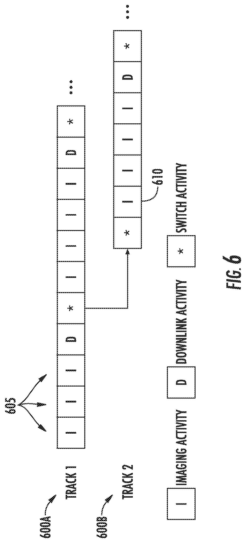
[0014] FIG. 5 depicts a flow diagram of an example method for selectively communicating with and controlling satellites to acquire image data according to example embodiments of the present disclosure;
[0015] FIG. 6 depicts example image acquisition tracks according to example embodiments of the present disclosure;
[0016] FIG. 7 depicts a flow diagram of an example method for satellite imaging control according to example embodiments of the present disclosure;
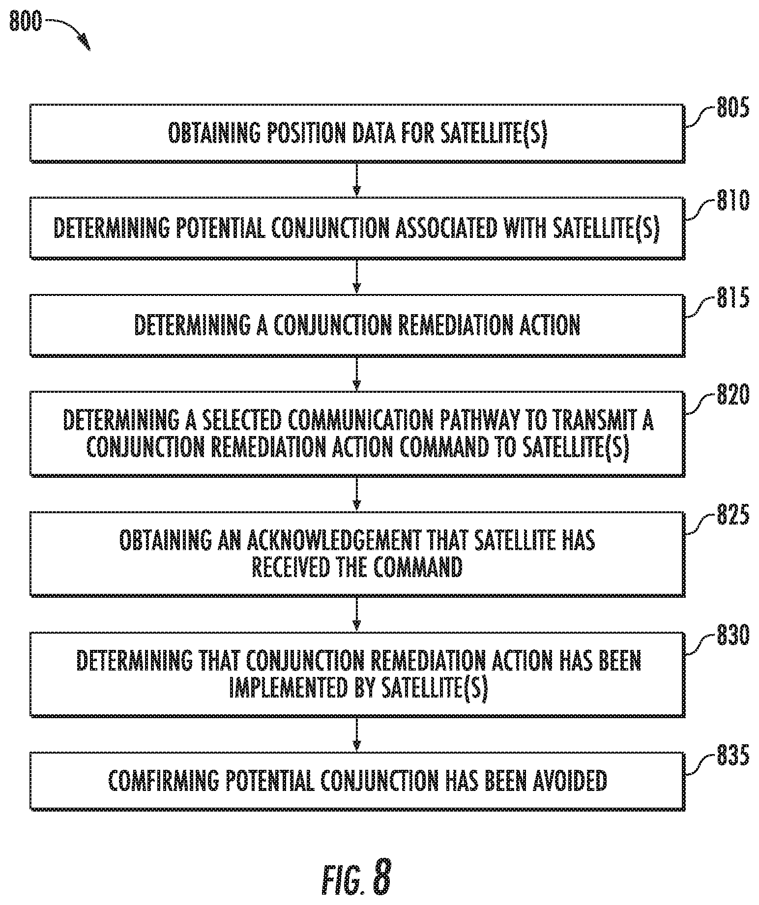
[0017] FIG. 8 depicts a flow diagram of an example method for satellite control for conjunction avoidance according to example embodiments of the present disclosure; and
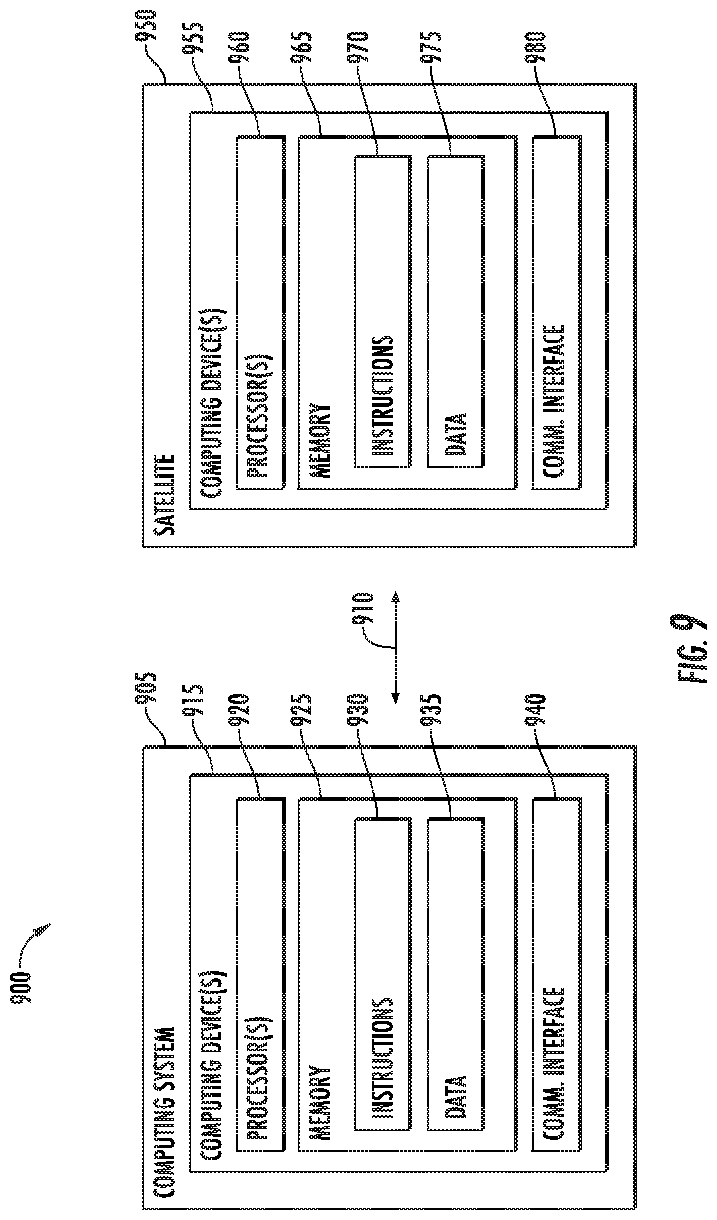
[0018] FIG. 9 depicts example system components according to example embodiments of the present disclosure.
DETAILED DESCRIPTION
[0019] Example aspects of the present disclosure are directed to systems and methods for persistent, near real-time communication with satellites and the selection of various communication pathways to efficiently utilize the resources available for communicating with the satellites. For instance, an entity can provide an imaging service by which a user can request image data of a particular target (e.g., a geographic area on Earth, another planet, celestial body, portion of the universe, etc.). The request can indicate the location of the target to be imaged and can be associated with a priority. The priority can indicate, for example, how quickly the user would like to have the image data acquired by a satellite and/or delivered to the user. Based on the request, a satellite command system can determine whether any of the satellites associated with the entity (e.g., owned, operated by, leased, accessible to, etc.) are available to acquire the image data of the specified target and within the given priority time constraints.
[0020] In the event a satellite is available to acquire the requested image data, the satellite command system can select a satellite (e.g., Low Earth Orbit (LEO) satellite, a Medium Earth Orbit (MEO) satellite, etc.) to acquire the image data and select an appropriate communication pathway by which to send an image acquisition command to the selected satellite. For example, in the event that the user submits a higher priority request, the satellite command system can select a near-real time communication pathway ("RT communication pathway") via which the image acquisition command is transmitted indirectly to the selected satellite via a relay satellite (e.g., a geostationary satellite). This RT communication pathway can allow the command to be communicated to the selected satellite in at least near real-time without any special pointing requirements (at any time), which may avoid tasking delays. In the event that the user submits a lower priority request, the satellite command system can select a "standard communication pathway" via which the image acquisition command is transmitted directly to the selected satellite (e.g., without the use of an intermediate geostationary satellite). In such a scenario, the standard communication pathway may require certain satellite pointing parameters to transmit the image acquisition command to the selected satellite (e.g., when the satellite is within a certain range of a ground command center).
[0021] Once the communication pathway is selected, the satellite command system can transmit the image acquisition command to the selected satellite via that communication pathway and eventually receive the requested image data (e.g., via satellite downlink). In this way, the technology described herein provides multiple communication pathways for communicating with satellite(s). This provides flexibility to utilize certain pathways based on the priority of the image acquisition. Moreover, by including the RT communication pathway, the systems and methods of the present disclosure provide a low size, weight, and power (SWaP) persistent communication solution for low data rate applications (e.g., launch and early orbit operations (LEOP), time-critical satellite tasking operations, command acknowledgements, critical status reports, anomaly recovery operations, conjunction assessment and collision avoidance, etc.), as further described herein.
[0022] The systems and methods described herein provide a number of technical effects and benefits. For instance, the systems and methods of the present disclosure allow for more efficient satellite communications that reduce latency presented by communication methods that include orbital access/pointing/range requirements toward ground stations for uplink and downlink. Moreover, the communication technology described herein provides a global communication pathway by which an entity can persistently command its associated satellites. For example, the beams provided by the intermediate satellites can provide coverage over the entire earth and provide access to all target satellites at all times. This can allow for the near real-time adjustments to improve satellite image capture, damage mitigation (e.g., collision avoidance, etc.), trajectory correction, interference reduction, etc.
[0023] The systems and methods of the present disclosure also provide an improvement to satellite computing technology. For instance, the computer-implemented methods and systems improve the ability to control and command satellites (e.g., for the acquisition of data such as, for example, image data) via a near real-time persistent communication pathway. For example, a computing system can obtain a request for image data. The request can be associated with a priority for acquiring the image data. The computing system can determine an availability of a plurality of satellites to acquire the image data based at least in part on the request. The computing system can determine a selected satellite from the plurality of satellites to acquire the image data based at least in part on the availability of the selected satellite. The computing system can determine a selected communication pathway of a plurality of communication pathways to transmit an image acquisition command to the selected satellite based at least in part on the priority for acquiring the image data. As further described herein, the plurality of communication pathways includes a first communication pathway via which the image acquisition command is directly communicated to the selected satellite (e.g., a standard communication pathway) and a second communication pathway via which the image acquisition command is indirectly communicated to the satellite via a geostationary satellite (e.g., a near real-time persistent communication pathway). The computing system can send the image acquisition command to the selected satellite via the selected communication pathway. In this way, the computing system can selectively determine what communication pathway is appropriate given the priority of the request. This can save bandwidth resources of the communication pathways by aligning the pathways with the appropriate tasking. Moreover, the computing system can utilize the persistent communication pathway (without specific orbital access or pointing requirements) to transmit data to and receive data from a satellite at all times. This can allow for better communication of commands, status reports, avoidance instructions, anomaly recovery operations, etc.
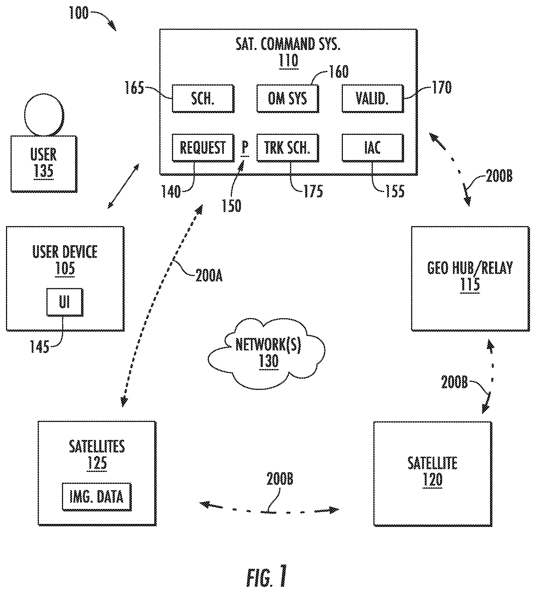
[0024] With reference now to the FIGS., example embodiments of the present disclosure will be discussed in further detail. FIG. 1 depicts a diagram of an example system 100 for controlling imaging satellites. For example, the system 100 can include a user device 105, a satellite command system 110, geostationary hub system(s) ("GEO hub(s)") 115, geostationary satellite(s) 120, and a plurality of satellites 125 (e.g., a constellation of imaging satellites). These components can be configured to communicate via one or more networks 130. The user device(s) 105 can be associated with a user 135. The satellite command system 110 can be associated with an entity that provides image data services and/or controls one or more satellite(s) 125. The GEO hub(s) 115, geostationary satellite(s) 120, and/or the satellites 125 can be associated with the entity and/or a different entity (e.g., that allows for the access/use of such assets). Although the use of geostationary satellite(s) is described in the example embodiments herein, another type of relay satellite can be utilized in the systems and methods of the present disclosure.
[0025] The user device(s) 105 can be desktop computer, laptop computer, mobile device, server system, and/or other types of user devices. The user device(s) 105 can be configured to allow a user 135 to submit a request 140 for acquiring image data. For example, the user device(s) 105 can be configured to present one or more user interfaces 145 (e.g., via one or more display devices) that allow the user 135 to provide user input to request image data. Data indicative of the user interface(s) 145 can be provided by a computing system associated with the entity (e.g., the satellite command system 110, etc.) over the network(s) 130. The user interface(s) 145 can be presented via a software application, a website, browser, etc. The user 135 can provide user input (e.g., text input, voice input, touch input, selection input, etc.) via the user interface(s) 145 to select one or more parameters associated with the requested image data. For example, the user input can specify an imaging target (e.g., a location, geographic area, building, structure, etc.). The user input can specify the imaging target based on location information (e.g., coordinates, etc.), semantic name, identifier, and/or other information that identifies the target to be imaged. In some implementations, the user input can specify a time parameter (e.g., timeframe, point in time, etc.) at which the image data of the target is preferred to be acquired. In some implementations, the user input can specify a time parameter (e.g., timeframe, point in time, etc.) by which the image data of the target is preferred to be made available to the user 135 (e.g., delivered, available for download, viewing, etc.).
[0026] The request 140 can be associated with a priority 150 for acquiring the image data. The priority 150 can be a standard priority by which it is sufficient for the image data to be acquired in a standard timeframe (e.g., over several hours). As further described herein, a standard priority can indicate that an associated image acquisition command can be placed in an imaging schedule/queue as it is received, without preferential treatment. In some implementations, the priority 150 can be an intermediate priority by which the image data is to be acquired and/or made available to the user 135 sooner than the standard timeframe. For example, as further described herein, the intermediate priority can indicate that an associated image acquisition command is to be given preferential treatment over the other pending requests (e.g., by moving the associated image acquisition command ahead of previously pending commands in a schedule/queue, by moving downlink and/or delivery time ahead in a schedule/queue, etc.). In some implementations, the priority can be a high priority, which can indicate that the requested image data is to be acquired and/or made available in a higher and/or the highest available rush manner. For example, as further described herein, a high priority can indicate that an associated image acquisition command is to be communicated to a satellite (e.g., via a particular communication pathway) in manner than expedites image acquisition and delivery.
[0027] The priority 150 associated with the request for image data can be determined in a variety of manners. In some implementations, the user 135 can select the priority 150 associated with the request 140. For example, the user interface 145 may include one or more user interface element(s) (e.g., buttons, toggles, menus, lists, fields, etc.) that allow the user 130 to select the priority 150 (e.g., standard priority, intermediate priority, high priority, etc.) associated with the request 140. In some implementations, the ability to select such an element may be based at least in part on whether the entity can meet the request with the selected priority. For example, a computing system associated with the entity (e.g., the satellite command system 110) can determine whether one or more of the plurality of satellites 125 would be available to acquire image data of the requested target in the expedited manner associated with a high priority request (e.g., based on current/future satellite location, trajectory, memory resources, etc.). In the event that the entity can meet such a prioritized request (e.g., due to satellite availability), the user interface 145 can present a user interface element and/or other option for selecting a high priority. In the event that the entity cannot meet such a prioritized request (e.g., due to satellite unavailability), the user interface 145 may not present a user interface element and/or other option for selecting a high priority (e.g., greying-out element, omitting element from user interface, etc.).
[0028] In some implementations, the priority 150 associated with a request 140 can be determined based at least in part on a time parameter associated with the request. For example, the priority 150 of the request 140 can be determined based at least in part on a time by which the user 135 specifies that the image data is to be acquired and/or made available. By way of example, in the event that the user 135 specifies that the image data should be acquired and/or made available in less than one hour, the request 140 can be associated with a high priority. In another example, in the event that the user 135 does not specify that the image data should be acquired and/or made available within a certain timeframe, the request 140 can be associated with a standard priority. Such a determination can be made, for example, by the satellite command system 110 and/or another system.
[0029] In some implementations, the priority 150 can be determined based at least in part on the user 135 and/or type of user 135. For example, in the event that the user 135 is considered a higher value customer (e.g., due to a certain subscription, purchase history, contract, etc.), the priority 150 associated with a request can be determined to be a high priority. In another example, in the event that the user 135 is associated with a type of entity that generally needs/prefers expedited image data (e.g., an emergency response entity, etc.), the priority 150 associated with a request 140 can be determined to be a high priority. Such a determination can be made, for example, by the satellite command system 110 and/or another system.
[0030] In some implementations, the priority 150 can be determined based at least in part on the target (e.g., type of target, location, etc.). For example, in event that the type of target may be subject to change at a higher rate (e.g., an area experiencing a wildfire), the priority 150 associated with a request can be determined to be a high priority. In another example, in the event that the type of target may be subject to change at a lower rate (e.g., a park undergoing a long-term reconstruction project), the priority 150 associated with a request 140 can be determined to be a high priority. In some implementations, the priority 150 may be based at least in part on the location of the target. For example, the target may include a movable and/or moving object (e.g., one or more automobiles). The target may be moving such that it will be subject to conditions that would make it more difficult to acquire image data of the target (e.g., the automobile(s) that are driving along a path that enters a tunnel). In such a case, the priority 150 associated with a request 140 can be determined to be a high priority (e.g., so that image data is acquired prior to the automobile(s) entering the tunnel). Such a determination can be made, for example, by the satellite command system 110 and/or another system.
[0031] The satellite command system 110 can be configured to obtain the request 140 for the image data from the user device(s) 105 (e.g., via the network(s) 130). The satellite command system 110 can parse the request (e.g., a data set, etc.) to determine the location of the target to be imaged and the time within which the image data is preferred to be acquired and/or made available to the user 135. As described herein, such timing can be determined based at least in part on a priority 150 and/or time parameters explicitly provided by the user 135.
[0032] The satellite command system 110 can be configured to determine an availability of the plurality of satellites 125 to acquire the image data based at least in part on the request 140. For example, the satellite command system 110 can obtain data associated with the satellites 125 (e.g., on a periodic basis, on-demand basis, on a scheduled basis, etc.) and determine whether any of the satellites 125 are available to acquire image data of the target within a timeframe that is sufficient for the request 140 (e.g., given the associated priority 150). The data associated with the satellites 125 can be indicative of various parameters associated with the satellites 125. For instance, the data associated with the satellites 125 can include a schedule indicative of the pending image acquisition commands/sequences of a given satellite or group of satellites. Additionally, or alternatively, the data associated with satellites 125 can include data indicative of the past, present, and/or future trajectory of the satellite(s). Additionally, or alternatively, the data associated with the satellites can include information associated with the power resources (e.g., power level, etc.), memory resources (e.g., storage availability, etc.), communication resources (e.g., bandwidth), etc. of the satellite(s). Additionally, or alternatively, the data associated with the satellites 125 can include health and maintenance information associated with the satellite(s) 125 (e.g., maintenance schedules, damage reports, other status reports, etc.). Additionally, or alternatively, the data associated with the satellites 125 can include data indicative of the type and/or status of the hardware (e.g., antenna, communication interfaces, etc.) and/or software onboard a satellite.
[0033] The satellite command system 110 can be configured to determine whether at least one satellite is available to acquire image data in accordance with the request 140 based at least in part on the data associated with the satellites 125. For example, the satellite command system 110 can determine whether a satellite 125 (e.g., with sufficient power, memory, communication resources, etc.) is on a trajectory or can be moved to a trajectory/position that would allow the satellite 125 to acquire image data of a target (e.g., an area experiencing a wildfire) within a timeframe that meets the request 140 (e.g., within a timeframe associated with a high priority request). If so, the satellite command system can determine that a satellite from the plurality of satellites 125 is available to acquire the requested image data and can accept the request. Additionally, or alternatively, the satellite command system 110 can determine availability based on the currently scheduled imaging tasks of the satellites and whether such a task can be disturbed. In some implementations, the satellite command system 110 can provide a confirmation message to the user 135 (e.g., via the user interface 145).
[0034] The satellite command system 110 can be configured to select a satellite from the plurality of satellites to acquire the image data based at least in part on the availability of the satellites 125 to acquire the image data. For example, in the event that only one satellite is available, the satellite command system 110 can select that available satellite to acquire the image data of the target. In some implementations, the satellite command system 110 can select a satellite from among a plurality of satellites that are available to acquire the image data. For example, the satellite command system 110 can perform an optimization analysis to determine which of the satellites 125 can be chosen to acquire the requested data in an expedited manner while minimizing the impact (e.g., time delay) on the other pending tasks and/or the satellite itself (e.g., power/memory resources).
[0035] The satellite command system 110 can be configured to generate an image acquisition command 155 for instructing a satellite 125 to acquire image data. The image acquisition command 155 can include parameters for a satellite 125 to utilize in order to acquire the requested image data. For example, the image acquisition command 155 can include data indicative of a location of the target, the order in which the associated data is to be acquired relative to other imaging tasks, a position/orientation of the satellite 125, sensor settings (e.g., camera settings, etc.), and/or other information. In some implementations, as further described herein, an image acquisition command 155 can include a plurality of image acquisition tracks that indicate the sequences in which a satellite 125 is to acquire image data.
[0036] The satellite command system 110 can be configured to transmit image acquisition commands to the selected satellite via a plurality of communication pathways 200A-200B. For instance, the plurality of communication pathways 200A-B can include a first communication pathway 200A. The first communication pathway 200A can include a communication pathway via which an image acquisition command 155 is sent directly to the satellite 125. For instance, a signal can be sent from a ground-based command center a satellite 125 when the orbital access and pointing/range requirements of that pathway are met (e.g., when the satellite is in an orbit position to receive a transmission from a ground-based command center). The first communication pathway 200A may allow for larger sizes of data to be transmitted to a satellite 125. Due to the orbital access and pointing requirements, the first communication pathway 200A may also have latency drawbacks for uplink and/or downlink. Thus, the first communication pathway 200A may not be a ubiquitous, near-real time communication mechanism for transmitting data to and/or from the satellite(s) 125. The first communication pathway 200A may also be referred to as the "standard communication pathway 200A".
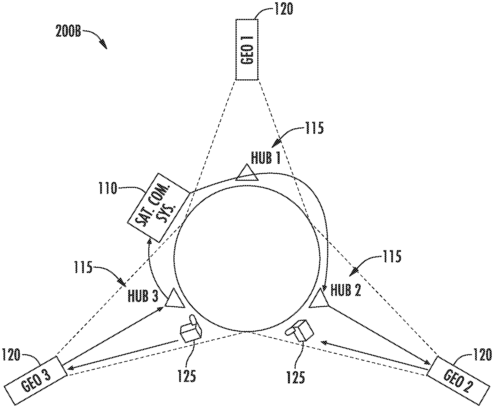
[0037] The plurality of communication pathways 200A-B can include a second communication pathway 200B. The second communication pathway 200B can include a communication pathway via which an image acquisition command is indirectly communicated to the satellite via a GEO hub 115 and/or a geostationary satellite 120. The GEO hub(s) 115 can be ground stations operated by the entities associated with the geostationary satellites 120. The geostationary satellites 120 can be satellites that travel at an orbit above the surface of the earth (or other body) and that generally provide line-of-sight coverage of a third of the Earth (or other body). For example, a single geostationary satellite 125 can be on a line of sight with about 40 percent of the earth's surface. Three such satellites, each separated by 120 degrees of longitude, can generally provide coverage of the entire Earth. This can allow the second communication pathway 200B to provide a near-real time, persistent and ubiquitous communication solution for the satellite command system 110 to communicate with the satellites 125. The second communication pathway 200B may also be referred to as the "RT communication pathway".
[0038] FIG. 2 provides a diagram overview of the RT communication pathway 200B.
[0039] For example, the RT communication pathway 200B can include a GEO communication infrastructure. One example GEO communication infrastructure that can be used to provide a near real-time communication solution is Very Small Aperture Terminal (VSAT). This can include a two way satellite communication system. For instance, the RT communication pathway 200B can include a plurality of geostationary satellites 120 with architecture for providing global beams such as, for example, bent-pipe C-band transponders providing global coverage beams. For example, as shown, three geostationary satellites 120 (e.g., with global C-band beams) placed 120 degrees apart can provide global coverage (e.g., at a 500 km low earth orbit altitude). The bent-pipe architecture can mirror the uplink channel to a lower frequency downlink channel (e.g., 6 GHz to 4 GHz). C-band transponders can be, for example, 36 MHz wide, while a maximum global covered latitude can be .+-.81.degree. for terrestrial stations and .+-.90.degree. for 500 km to 700 km low earth orbit. Such an approach can provide global low earth orbit coverage, a deterministic latency (e.g., .about.10 s), lower cost, and a flexible bent-pipe architecture that allows for full control of modulation, coding, and encryption. The infrastructure of the RT communication pathway 200B (e.g., the GEO hub(s) 115, geostationary satellite(s) 120, etc.) can be associated with one or more other entities (e.g., third party vendors) that are different than the entity associated with the satellite command system 110 (e.g., the imaging service provider). In addition to C-band global beams, regional and spot beams are available at C, Ku, or Ka band that provide effective isotropic radiated power (EIRP) and gain over noise temperature (G/T). By leasing regional beams on multiple GEO satellites (more than 3) global coverage could be achieved at higher data rates.
[0040] To establish a network connection for the RT communication pathway 200B, the satellite command system 110 can utilize dedicated bandwidth from the geostationary satellites 120 and GEO hub(s) 115. A link can be established to a particular satellite 125 (e.g., a LEO satellite, MEO satellite, etc.) by selecting the corresponding geostationary satellite 120 and GEO hub 115. As described herein, the GEO hub(s) 115 can be ground stations with communication infrastructure for communication with the geostationary satellites 120. In some implementations, modems tuned to dedicated frequencies for the entity associated with the satellite command system 110 can be housed at the GEO hub(s) 115. The RT communication pathway 200B can achieve, for example, a round trip time of 0.5 seconds up to several seconds to transmit an image acquisition command 155 to a satellite 125.
[0041] The RT communication pathway 200B may not require special pointing constraints for enforcing tasking operations (e.g., transmitting image acquisition commands). To allow for on-demand, persistent, near real-time tasking, a receiver on the satellite 125 may be kept on. In some implementations, tasking reaction time can be on the order of minutes depending on the image acquisition command length (e.g., a deterministic quantity). Tasking can be done in an open loop fashion. Tasking data rates can be, for example, on the order of 10 s of bits per second (bps) without pointing and could go up to 500 bps with pointing (if desired).
[0042] The satellite 125 may not communicate (e.g., to the satellite command system 110) an acknowledge message of the receipt of the image acquisition command 155. This can help to avoid the consistent powering and positioning (e.g., toward a geostationary satellite 120) of a satellite transmitter. In some implementations, to establish a reverse link for an acknowledgement (if desired), a satellite 125 can turn the transmitter on and point it towards a geostationary satellite(s) 120 to follow the same/similar pathway to the satellite command system 110 as the image acquisition command 155.
[0043] Image acquisition commands 155 sent from the satellite command system 110 can be transmitted via the network(s) 130 (e.g., an internet network, etc.) to a GEO hub 115. The GEO hub 115 can transform an image acquisition command 155 to a radio signal. The GEO hub 115 can provide frequency translation, amplification, and retransmission to the geostationary satellite 120.
[0044] The RT communication pathway 200B can allow the system 100 to overcome certain communication-related issues. For example, to mitigate potential Doppler problems, the system 100 can utilize a bandwidth expansion technique such as, for example, direct sequence spread spectrum (DSSS) scheme. Bandwidth expansion can ease carrier synchronization and tracking, ease reference frequency oscillator tolerances, allow the increase of total transmitted power without violating maximum power spectral densities (PSD), etc. Moreover, DSSS technique can allow for the use of the same shared spectrum to communicate with a fleet of satellites 125 (e.g., LEO satellites). In another example, uplink transmissions (e.g., at 6 GHz) can be subject to an angular emission mask to avoid interference to adjacent geostationary satellites. In some implementations, assets in the RT communication pathway 200B can use a small aperture low gain antenna that could illuminate multiple geostationary satellites. To mitigate this problem, one example solution can be to operate with a low power transmitter (1 W) occupying a particular bandwidth (e.g., 1 MHz bandwidth).
[0045] As shown, in the RT communication pathway 200B, the satellite command system 110 can communicate an image acquisition command 155 to a GEO hub 115. As further described herein, the GEO hub 115 can communicate the image acquisition command 155 (e.g., a radio signal translation thereof) to a geostationary satellite 120. The geostationary satellite 120 can communicate the image acquisition command 155 to the selected satellite 125 that is to acquire the requested image data. In some implementations, a GEO hub 115 can communicate the image acquisition command 155 to one or more other GEO hubs 115. This can allow the GEO hub(s) 115 to communicate the image acquisition command 155 to the geostationary satellite 120 that can most effectively transmit the image acquisition command 155 to the selected satellite 125. For example, a geostationary satellite 120 that is associated with a selected satellite 125 (e.g., with the selected satellite in the coverage area, within LOS of the selected satellite 125, etc.) may be the most effective intermediary for communicating with that selected satellite 125.
[0046] The satellite(s) 125 can be configured to obtain the image acquisition command 155 (e.g., a radio signal translation thereof, etc.) and acquire the requested image data. The satellite(s) 125 can include hardware that allows the satellite(s) 125 to obtain data via the RT communication pathway 200B and/or communicate data via the RT communication pathway 200B. For example, with reference to FIG. 3, a satellite 125 can include a subsystem 300 that is designed to interface directly with a satellite power/data bus 305 (e.g., with minimal hardware and software impact). The subsystem can use the same power and data module (PDM) circuit 310 used by other subsystem(s) of the satellite(s) 125. This can include, for example, utilizing a bus voltage (e.g., nominal 28V, range of 22-32 V, etc.) and/or data interface (Dual CAN bus, 1 Mbit/s, etc.). The subsystem 300 can include a baseband processor (e.g., a microcontroller, CPLD, FPGA, etc.) that is configured to manage antenna functions (e.g., all the radio functions that require an antenna, etc.).
[0047] The subsystem 300 can provide RF interfaces for the transmit (Tx) external antenna 320 and/or receive (Rx) external antenna 325. A satellite 125 can utilize full-duplex operation, such that the receiver is enabled at all times. The satellite 125 can utilize frequency separation f1, f2, etc. (e.g., 6 GHz/4 GHz Tx/Rx frequency separation) for effective isolation between the receiving (Rx) and transmitting (Tx) paths.
[0048] The expected power consumption of the subsystem 300 can be, for example: PDM subsystem: 1 W, 100% duty; Baseband processor: 1 W, 100% duty; Rx chain: 1 W, 100%; and Tx chain: 5 W, 1% duty. A link for the RT communication pathway 200B can be routed through an EPB of a satellite 125. This can be implemented by either piggy backing onto an existing EPB-PDM link and creating a spliced connection and/or modifying the EPB.
[0049] A satellite 125 can include antenna(s) that help allow the satellite 125 to utilize the RT communication pathway 200A. For instance, a satellite 25 can include an omnidirectional antenna that can be configured to close the link for tasking. Additionally, or alternatively, a satellite 125 can include a phased array antenna (e.g., for higher data rates). Two separate antennas can be included for the forward and/or reverse link.
[0050] An antenna can be mounted in the z-axis in the zenith pointing (anti-nadir) direction. The mounted antenna can have sufficient gain under all pointing modes to at least one geostationary satellite 120.
[0051] In some implementations, an antenna for use with the RT communication pathway 200B can include a quadrifilar helix antenna. A quadrifilar helix antenna has a broad radiation pattern and can provide 0 dBi gain to +-70 degrees. It has very good axial ratio across the entire beam. In some implementations, more than one receive antenna can be included in a satellite 125 to help ensure that there are no gaps in coverage even at the extreme off-axis angles (e.g., a multi-input multi-output (MIMO) antenna architecture). A patch antenna or a patch array can be another option (e.g., for a directional beam).
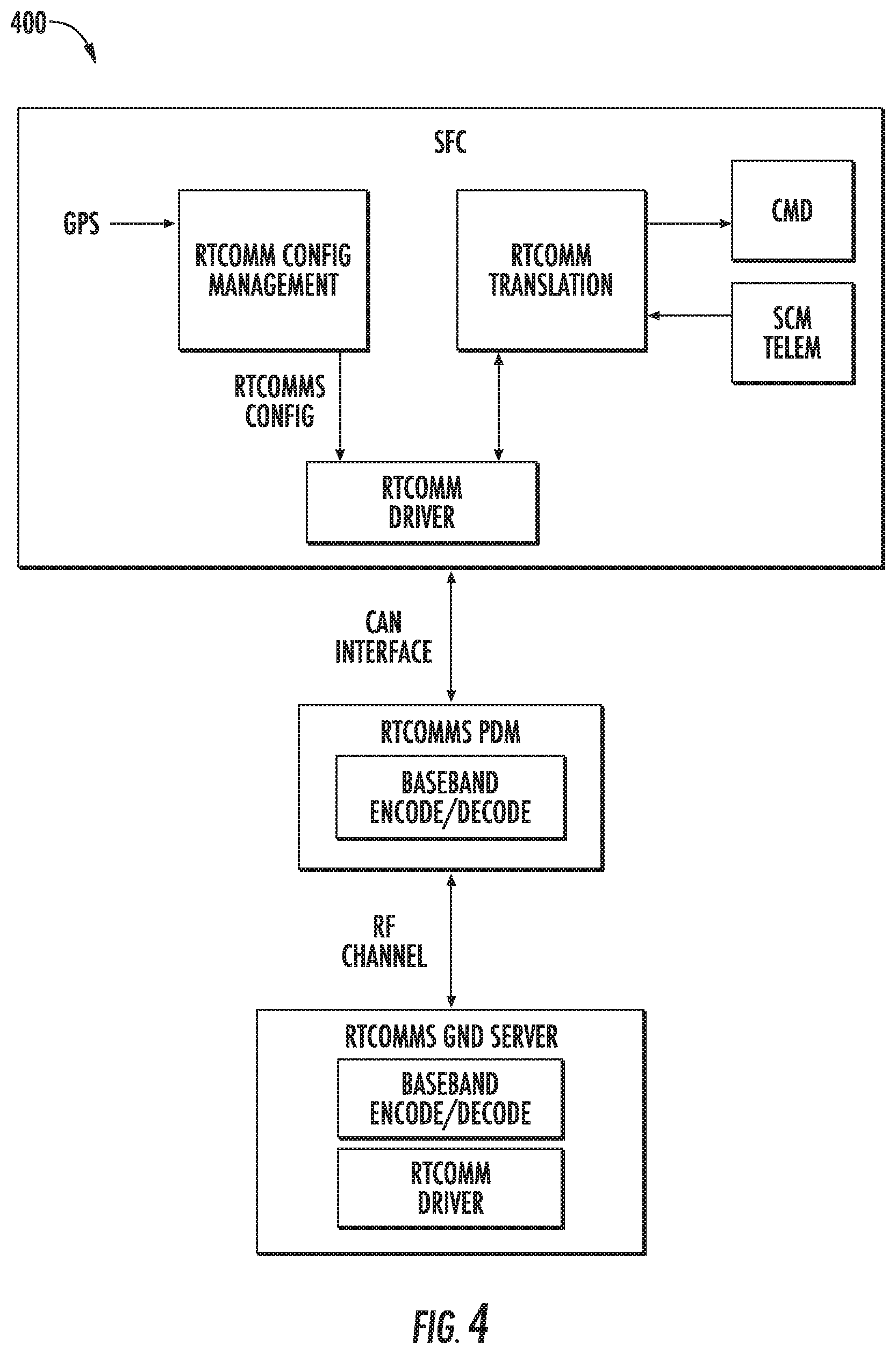
[0052] FIG. 4 depicts a block diagram 400 of the onboard satellite software modules that may be utilized in the satellite flight software to support the RT communication pathway 200B. To utilize the RT communication pathway 200B, the satellite flight software can include an execution model (e.g., pthread, etc.) to support certain requirements for the RT communication pathway 200B, software to support the hardware a translation layer (e.g., providing a highly efficient packet protocol), a commanding interface to utilize the low bandwidth channel (e.g., 10 s bits/second), an interface to sequence loading, module(s) for attitude control system (ACS) Target tracking, a module for image (IMG) captures, module(s) for emergency commanding, module(s) for real time telemetry feedback for critical satellite states module(s) for providing the ability to change pathway settings autonomously based on position (e.g., GPS, etc.) and specific geostationary satellite footprint that has the best line-of-sight (LOS) for the satellite 125, ground packages to encode/decode data transmitted via the RT communication pathway 200B, potentially a module for supporting higher bandwidth in the RT communication pathway 200B (e.g., utilizing pointing requirements), and/or other modules.
[0053] Since the bandwidth going through the RT communication pathway 200B can be low, the system 100 can utilize an optimized solution in terms of the amount of bytes required to change an imaging activity. This can be achieved, for example, in the following ways: by providing a highly optimized interface to change a sequence with ACS and IMG commands on the satellite, by providing a highly optimized packet protocol with low overhead going over the RT communication pathway 200B, by creating the smallest common denominator when it comes to changing an imaging activity, and/or other approaches. In some implementations, sequences are utilized for image events. The satellite 125 can treat the loading and activating of a specific sequence id as mutually exclusive in order to prevent race condition when executing a sequence. This means that a sequence can be the lowest common denominator. Additionally, or alternatively, only a part of a schedule that is affected by a high priority request can be updated. This can include allowing the satellite software to keep loading and activating a specific sequence identifier as mutually exclusive with ground scheduler requirements to allow multiple imaging activities in one or more sequences.
[0054] The RT communication pathway 200B can be associated with various security-related features. For example, the satellite command system 110, the GEO hub(s) 115, the geostationary satellite(s) 120, and/or the satellite(s) 125 can utilize encryption and authentication of commands and telemetry, command level (operational, privileged) enforcement, replay protection, periodic key rotation, and/or other security mechanisms.
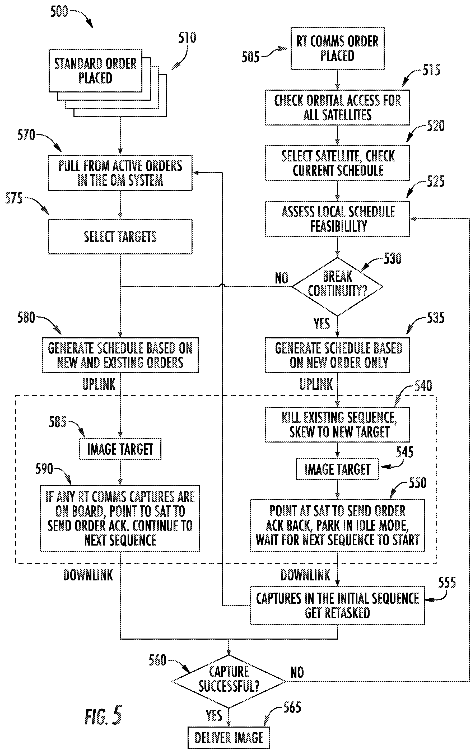
[0055] FIG. 5 depicts a flow diagram of an example method 500 for selectively communicating with and controlling satellites to acquire image data according to example embodiments of the present disclosure. One or more portion(s) of the method 600 can be implemented by a computing system that includes one or more computing devices such as, for example, the computing systems described with reference to the other figures (e.g., a satellite command system 110, a GEO hub 115, a geostationary satellite 120, a satellite 125, etc.). Each respective portion of the method 500 can be performed by any (or any combination) of one or more computing devices. Moreover, one or more portion(s) of the method 500 can be implemented as an algorithm on the hardware components of the device(s) described herein. FIG. 6 depicts elements performed in a particular order for purposes of illustration and discussion. Those of ordinary skill in the art, using the disclosures provided herein, will understand that the elements of any of the methods discussed herein can be adapted, rearranged, expanded, omitted, combined, and/or modified in various ways without deviating from the scope of the present disclosure. FIG. 5 is described with reference to elements/terms described with respect to other systems and figures for example illustrated purposes and is not meant to be limiting. One or more portions of method 500 can be performed additionally, or alternatively, by other systems.
[0056] At (505) and (510), the satellite command system 110 can obtain a request for image data. At (505), the request can be associated with a high priority, which would lend itself to communication via the RT communication pathway 200B. To properly handle a request that is employing the RT communication pathway, such a request can be able to jump the queue or will have a different order management (OM) pathway. As described herein, a user 135 can select a high priority (RT communication pathway 200B) for the requested image data via a user interface 145 (e.g., presenting a browser, etc.). Such a selection would initiate a fast feasibility evaluation by the satellite command system 110 (e.g., an order management (OM) system 160, a scheduler system 165, a validation system 170 as shown in FIG. 1), at (515) to (530). The satellite command system 100 can check orbital access for the plurality of satellites 125 (at 515), select an available satellite and check its current schedules (at 520), determine the feasibility of adjusting the current schedule for the request and determining whether continuity of the current schedule is appropriate (at 530). The satellite command system 110 can inform the customer if access is available in a high priority timeframe (e.g., the next TBD minutes). If there is no access within that time, the OM system 160 can recommend an intermediate priority request (e.g., a request that is given priority within the standard communication pathway 200A). In addition to feasibility, an updated priority tiering model can be employed to make sure that if any other users get "bumped" from their previously scheduled image acquisition, it is of a sufficiently lower priority. The access and priority criteria being met, the user 135 can confirm that the user 135 wants to make the request.
[0057] In some implementations, the satellite command system 110 can communicate and/or stored data indicative of a schedule change. Such data can be utilized for a variety of purposes. For example, the data indicative of the schedule change can be utilized for user notification and expectation management (e.g., with respect to capture/deliver timelines) as well to keep track to support the scheduler in retasking bumped requests. Additionally, or alternatively, operations/functions may utilize the data indicative of the schedule changes for satellite troubleshooting and/or situational awareness. Additionally, or alternatively, a data pipeline can utilize such data to remain informed of what image data collections to expect, keeping the platform in sync.
[0058] At (535), the satellite command system 110 (e.g., the schedule system 165) can generate image acquisition commands 155 for a satellite 125. For example, the satellite command system 110 can package the sequences in the appropriate order to signal to the satellite 125 that it is overwriting a nominal imaging sequence. The image acquisition command 155 can be communicated via the RT communication pathway 200B. For example, the determined sequence can be communicated to a GEO hub 115, which in turn can communicate it to an associated geostationary satellite 120.
[0059] As described herein, in some implementations, the satellite 125 may not communicate an acknowledgement of the image acquisition command 155. Accordingly, it is possible that the command could fail enroute, so there may be a period of time where the satellite state is unknown. As a result, the satellite command system 110 can retain information on both the collection with the request sent via the RT communication pathway 200B and the previously-scheduled collection. These two states can be held until a confirmation or failure is received from the satellite 125. This could happen, for example, within a few minutes after command transmission (e.g., if the command is successfully sent via the RT communication pathway 200B) and/or the next time the satellite 125 has a ground contact (if the RT command failed).
[0060] At (540)-(550), the satellite 125 can acquire image data as instructed via the RT communication pathway 200B. For example, the satellite 125 can obtain the newly generated schedule/sequence, kill/overwrite any existing sequences and adjust for the new target (at 540), and acquire the image data of the target (e.g., via an onboard camera, imaging system, etc.), at (545). The satellite 125 can point at a geostationary satellite 120 to communicate an acknowledgement (via the RT communication pathway 200B) that the image date was acquired, at (550). In this way, the user 135 can be notified of an imaging events success or failure (e.g., success known by acknowledgement sent via the RT communication pathway 200B, failure known by message sent via the RT communication pathway 200B or a lack of an acknowledgment following the imaging event, etc.). In some implementations, the satellite 125 can switch to an idle mode and wait for the next sequence to start. For bumped requests, the satellite command system 110 (e.g., the scheduler system 165, the OM system 160, etc.) can work to re-task the request and inform the bumped user of the change, and the satellite 125 can work to acquire the image data associated with the bumped requests, at (655).
[0061] In the event that the image data acquisition is successful (at 660), the image data acquired by the satellite 125 can be downlinked (e.g., via the standard communication pathway 200A, at the next ground site, etc.), at (565). A downlink tier can be leveraged to make sure that high priority image data (e.g., for which a command was sent via the RT communication pathway 200B) is the first image data downlinked from the satellite 125. The user 135 can be notified as soon as the image data arrives at the satellite command system 110 and/or an another system. In some implementations, a user 135 can access raw frames to speed up the user's access to the image data and drive their decisions in real time. Processed image data, when complete, can also be made available to the user 135. In the event that the image data acquisition is not successful (at 560), the satellite command system 110 can return to its feasibility analysis in an attempt to re-start the process.
[0062] In the event that the request is not suited for transmission via the RT communication pathway 200B (e.g., due to a lower priority, lack of feasibility, etc.), the request can follow the flow provided at (570) to (590). For example, the satellite command system 110 can pull from the pending requests (at 570), down select targets (at 575), and generate a new schedule based at least in part on the request (at 580). An image acquisition command 155 (e.g., including data indicative of the schedule) can be uplinked to the satellite 125 via the standard communication pathway 200A. At (585), the satellite 125 can process the image acquisition command 155 and acquire the image data of the target (e.g., in accordance with the schedule). At (590), if any high priority image data is onboard, the satellite 125 can send an acknowledgement via the RT communication pathway 200B and downlink such image data first. The satellite 125 can then downlink any lower priority image data (e.g., via the standard communications pathway 200A), for the successful image acquisitions.
[0063] With reference to FIG. 6, in some implementations, the satellite command system 110 can generate a plurality of image acquisition tracks 600A-B for a satellite 125. The plurality of tracks can include a first image acquisition track 600A and a second image acquisition track 600B. An image acquisition track 600A-B can include one or more sequences 605 (e.g., image acquisition commands). A sequence 605 can include an identifier, sequence lines (e.g., a line of command, a timestamp, args, etc.), a cyclic redundancy check (CRC), and/or other information. A sequence 705 can be indicative of an imaging activity, a downlink activity, or a switch activity. Each sequence 705 can activate the next sequence in the track that is meant to be run. In some implementations, a satellite 125 can go into a "safe mode" when it is not running a sequence.
[0064] The sequences 605 of the image acquisition track 600A-B can be uplinked to the satellite 125. For example, the image acquisition tracks 600A-B can be communicated to the satellite 125 via the standard communication pathway 600A (and/or the RT communication pathway 200B). The sequences 605 can be activated by the satellite 125 to begin performing the activities identified in that associated image acquisition track 600A-B.
[0065] The first image acquisition track 600A can be different than the second image acquisition track 600B. For example, the first image acquisition track 600A can include sequence number ranges 10001-20000 and the second image acquisition track 600B can be 20001-30000. Only one image acquisition track can be active at a given time. The satellite 125 can switch between the first and second image acquisition tracks 600A-B. For instance, an image acquisition track (e.g., the first image acquisition track 600A) can include a sequence that indicates a switch activity (shown as a "*" in FIG. 6). Upon activation of that sequence, the satellite 125 can switch to begin executing the sequences in another image acquisition track (e.g., the second image acquisition track 600B). This provides the ability to store a schedule onboard, and load an alternative schedule to the inactive track, and switch at the most opportune moment.
[0066] The following is an end-to-end example implementing a plurality of image acquisition tracks 600A-B for a satellite 125. A user 135 can submit a request 140 for the acquisition of image data. The priority 150 associated with the request 140 can be a high priority. The satellite command system 110 can generate an image acquisition track based at least in part on the request 140. For example, the satellite command system 110 (e.g., a track scheduling system 175 shown in FIG. 1) can analyze the existing schedule from a currently active track, make a copy of it, and insert the newly desired imaging activity based on the priority of this request and the other pending requests. In some implementations, a scheduling solution can include replacing all imaging between two switch activities with the imaging of the targets tasked using the RT communication pathway 600B. In some implementations, a scheduling solution can include having the satellite 125 acquire image data as well as possible (taking into account priorities etc.) between two switch activities, while including the tasked target. In some implementations, a scheduling solution can include having the satellite 125 acquire image data as well as possible while ensuring that the RT target is tasked while minimizing the impact on existing tasks so that current schedules are not impacted. Once the image acquisition track is generated, it can be checked by the validation system 170 (e.g., so as not to violate any constraints). The image acquisition track can be sent to satellite 125 (e.g., via the standard communications pathway 600A and/or the RT communication pathway 600B).
[0067] In some implementations, the satellite command system 110 can predict that a request may become a high priority request at a later time and generate a plurality of image acquisition tracks accordingly. For instance, a user 135 can submit a request 140 that does not indicate a priority 150 and/or indicates an intermediate or standard priority. The satellite command system 110 can be configured to determine that the priority 150 associated with the request 150 may potentially change to a high priority request. Such a determination can be made, for example, based on the user 135, the target, the target's locations, etc.
[0068] The satellite command system 110 can generate a plurality of image acquisition tracks to handle the potentially high priority request. For example, the satellite command system 110 can generate a first image acquisition track 600A that includes an image acquisition sequence associated with acquiring the requested image data. The first image acquisition track 600A can place an associated imaging activity sequence for the request in a manner for an intermediate or standard priority. The satellite command system 110 can generate a second image acquisition track 600B that includes an image acquisition sequence associated with acquiring the requested image data. The image acquisition sequence of the second image acquisition track 600B can be afforded a higher priority than in the first image acquisition track 600A. For example, the image acquisition sequence can be positioned in the second image acquisition in a position of higher priority ahead of other pending requests than is done in the first image acquisition track 600A. This can be a placement that is in accordance with a request that would be addressed via the RT communication pathway 200B. The satellite command system 110 can communicate data indicative of the first image acquisition track 600A and the second image acquisition track 600B to the satellite via the standard communication pathway 200A. The satellite 125 can active the first image acquisition track 600A.
[0069] In the event that the priority of the request changes (e.g., to a high priority), the satellite command system 110 can generate an image acquisition command 155 to cause the satellite 125 to switch from the first image acquisition track 600A to the second image acquisition track 600B. Such a command can be communicated to the satellite 125 via the RT communication pathway 200B. The satellite 125 can obtain the image acquisition command 155 indicative of the switching activity. The satellite 125 can switch from the first image acquisition track 600A to the second image acquisition track 600B based at least in part on the image acquisition command 155 indicative of the switching activity. This can allow the satellite 125 to implement the image acquisition sequence associated with the acquisition of the requested data sooner than under the first image acquisition sequence 600A. The image data can be downlinked (e.g., via the standard communication pathway 200A) after image acquisition and the image data can be made available to the user 135 (e.g., for download, preview, viewing, etc.).
[0070] The track-scheduling system 175 (shown in FIG. 1) can utilize at least a portion of the codebase of the scheduler system 165. The track-scheduling system 175 can be configured to run with a smaller scope (e.g., of one satellite, etc.), one or more targets, and for a shorter duration (less than the orbital period). The scheduling system 165 and the track-scheduling system 175 can generate different image acquisition tracks. For example, the schedule system 165 (e.g., the more robust scheduler) can generate the first image acquisition track 600A and the track-scheduling system 175 (e.g., the leaner scheduler) can generate the second image acquisition track 600B.
[0071] FIG. 7 depicts a flow diagram of an example method 700 for satellite imaging control according to example embodiments of the present disclosure. One or more portion(s) of the method 700 can be implemented by a computing system that includes one or more computing devices such as, for example, the computing systems described with reference to the other figures (e.g., a satellite command system 110, etc.). Each respective portion of the method 700 can be performed by any (or any combination) of one or more computing devices. Moreover, one or more portion(s) of the method 800 can be implemented as an algorithm on the hardware components of the device(s) described herein, for example, to control satellites to acquire and downlink image data. FIG. 7 depicts elements performed in a particular order for purposes of illustration and discussion. Those of ordinary skill in the art, using the disclosures provided herein, will understand that the elements of any of the methods discussed herein can be adapted, rearranged, expanded, omitted, combined, and/or modified in various ways without deviating from the scope of the present disclosure. FIG. 7 is described with reference to elements/terms described with respect to other systems and figures for example illustrated purposes and is not meant to be limiting. One or more portions of method 700 can be performed additionally, or alternatively, by other systems.
[0072] At (705), the method 700 can include obtaining a request for image data. For instance, the satellite command system 110 can obtain a request 140 for image data. As described herein, the request 140 can be submitted via a user device 105 that presents a user interface 145 for creating the request 140. The request 140 can be associated with a priority 150 for acquiring the image data. The priority can be specified by a user 130 and/or determined by the satellite command system 110, as described herein. The priority 150 can include, for example, a standard priority, an intermediate priority (e.g., a request to be scheduled ahead of standard requests), or a high priority (e.g., a request to be given a super priority that can initiate the utilization of a dedicated communication pathway).
[0073] At (710), the method 700 can include determining an availability of a plurality of satellites to acquire the image data. For instance, the satellite command system 110 can determine an availability of a plurality of satellites 125 to acquire the image data based at least in part on the request 140. By way of example, the satellite command system 110 can obtain and analyze data associated with the satellites 125 to determine if any would be available to acquire image data of the requested target within a timeframe that is sufficient for the request 140. As described herein, this can be based at least in part on the state of a satellite 125 (e.g., its available power resources, memory resources, current schedule, etc.), a trajectory of a satellite 125, and/or the other pending requests (e.g., can they be bumped and to what degree for this request).
[0074] At (715), the method 700 can include determining a selected satellite from the plurality of satellites to acquire the image data. For instance, the satellite command system 110 can determine a selected satellite from the plurality of satellites 125 to acquire the image data based at least in part on the availability of the selected satellite to acquire the image data. By way of example, the satellite command system 110 can run an optimization algorithm to determine which satellite can acquire the requested image data with the lowest impact on the current pending requests and/or the satellite itself/fleet.
[0075] At (720), the method 700 can include determining a selected communication pathway to transmit an image acquisition command to the selected satellite. For instance, the satellite command system 110 can determine a selected communication pathway of a plurality of communication pathways 200A-B to transmit an image acquisition command 155 to the selected satellite based at least in part on the priority 150 for acquiring the image data. As described herein, the plurality of communication pathways can include a first communication pathway 200A via which the image acquisition command 155 is sent directly to the selected satellite (e.g., the standard communication pathway). The plurality of communication pathways can include a second communication pathway 200B via which the image acquisition command 155 is indirectly communicated to the selected satellite via a geostationary satellite (e.g., the RT communication pathway).
[0076] By way of example, the priority 150 for acquiring the image data can be indicative of a high priority. In response, the satellite command system 110 can determine that the selected communication pathway is the second communication pathway via which the image acquisition command is indirectly communicated to the selected satellite via a geostationary satellite 120. As described herein, this RT communication pathway can provide a near real-time persistent communication pathway that can allow for expediting the acquisition of the image data. In another example, the priority 150 for acquiring the image data is not indicative of a high priority. In response, the satellite command system 110 can determine that the selected communication pathway is the first communication pathway via which the image acquisition command is sent directly to the selected satellite 125. As described herein, this standard communication pathway may include some delays due to pointing requirements for data transmission and, thus, may be appropriate for lower priority requests.
[0077] At (725), the method 700 can include sending the image acquisition command to the selected satellite via the selected communication pathway. For instance, the satellite command system 110 can send the image acquisition command 155 to the selected satellite via the selected communication pathway (e.g., the second communication pathway). In some implementations, the satellite command system 110 may not receive an acknowledgement of the receipt of the image acquisition command 115 by the selected satellite via the selected communication pathway (e.g., the second communication pathway).
[0078] At (730), the method 700 can include obtaining an acknowledgement that the selected satellite has acquired the image data. The selected satellite 125 can be configured to acquire the image data based at least in part on the image acquisition command 155. For example, the selected satellite can be configured to obtain the image acquisition command 115, and to adjust the selected satellite and acquire the image data based at least in part on the image acquisition command 155. This can include adjusting the position, orientation, etc. of the selected satellite 125 to acquire the image data.
[0079] In some implementations, the satellite can be configured to adjust an onboard imaging schedule based at least in part on the image acquisition command. For instance, the satellite command system 110 can determine that that the priority for acquiring the image data is a potentially high priority (e.g., indicating that a request may become a high priority at a later time). Such a determination can be based at least in part on the user 135, the target, etc. The satellite command system 110 can generate a first image acquisition track 700A that includes an image acquisition sequence associated with acquiring the image data. The satellite command system 110 can generate a second image acquisition track 700B (that is different than the first image acquisition track 600A). The second image acquisition track 700B can include an image acquisition sequence associated with acquiring the image data. The image acquisition sequence can be afforded a higher priority in the second image acquisition track 700B than in the first image acquisition track 600A, as described herein. The satellite command system 110 can communicate data indicative of the first image acquisition track 600A and the second image acquisition track 600B to the selected satellite 125.
[0080] The satellite command system 110 can determine that the priority 150 associated with acquiring the image data is a high priority (e.g., at a later time). The satellite command system 110 can communicate an image acquisition command to the satellite 125 based at least in part on the determination that the priority 150 is a high priority. The image acquisition command can be indicative of a command for the selected satellite to switch from the first image acquisition track 600A to the second image acquisition track 600B. The selected satellite can be configured to switch to from the first image acquisition track 600A to the second image acquisition track 600B and acquire the image data in accordance with the second image acquisition track 600B (e.g., so that the requested image data is acquired sooner).
[0081] At (735), the method 700 can include obtaining the image data acquired by the selected satellite. For instance, the satellite 125 can be configured to downlink the acquired image data to the satellite command system 110. The image data can be communicated via the first communication pathway (e.g., the standard communication pathway) and/or the RT communication pathway. The satellite command system 110 can obtain the image data acquired by the selected satellite 125 via the first communication pathway.
[0082] At (740), the method can include making the image data available to a user. For instance, the satellite command system 110 can make the image data available to a user 135. This can include, for example, communication the image data (e.g., a raw version, a processed version, etc.) to a user device 105, provide the image data for display via a user interface for viewing by the user, providing access to the image data for download, preview, etc.
[0083] While FIG. 7 describes the communication of image acquisition commands via a selected communication pathway, the present disclosure is not limited to such an embodiment. The command(s) communicated via the selected communication pathway can include other data and/or information. For instance, the command(s) can also, or alternatively, include data and/or information related to launch and early orbit operations (commissioning) commands, anomaly recovery operations, down linking high importance information (e.g., image tiles, critical system status (heath information), GPS radio sample data, etc.), radio ranging (e.g., as the path is deterministic/the relays are fixed and can be used to calculate ranging just as ground originated signals).
[0084] In some implementations, the systems and methods described herein can be utilized for conjunction avoidance and/or other short notice satellite orbit maneuvers. For instance, FIG. 8 depicts a flow diagram of an example method 800 for satellite control according to example embodiments of the present disclosure. In particular, the method 800 can be utilized for real-time satellite conjunction avoidance and/or other short term maneuver control. One or more portion(s) of the method 800 can be implemented by a computing system that includes one or more computing devices such as, for example, the computing systems described herein with reference to the other figures (e.g., a satellite command system 110, etc.). Each respective portion of the method 800 can be performed by any (or any combination) of one or more computing devices. Moreover, one or more portion(s) of the method 800 can be implemented as an algorithm on the hardware components of the device(s) described herein, for example, to control satellites (e.g., for conjunction avoidance). FIG. 8 depicts elements performed in a particular order for purposes of illustration and discussion. Those of ordinary skill in the art, using the disclosures provided herein, will understand that the elements of any of the methods discussed herein can be adapted, rearranged, expanded, omitted, combined, and/or modified in various ways without deviating from the scope of the present disclosure. FIG. 8 is described with reference to elements/terms described with respect to other systems and figures for example illustrated purposes and is not meant to be limiting. One or more portions of method 800 can be performed additionally, or alternatively, by other systems.
[0085] At (805), the method 800 can include obtaining position data for one or more satellites. For instance, the satellite command system 110 can obtain position data that is indicative of one or more past positions, one or more current positions, and/or one or more future positions of one or more satelittes. The positions can be described as a position along an orbit/trajectory, coordinate, radial position, position relative to the earth/portion of the earth/base station/other reference point, and/or in another form that is indicative of satellite's position/location. The future position(s) of the satellite can be expressed as a projected/predicted position and/or a future satellite trajectory.
[0086] The satellite command system 110 can obtain satellite environmental data. The satellite environmental data can include, for example, data indicative of one or more other objects within space and/or the surrounding environment of the satellite. This can include other hardware/equipment orbiting the earth, other objects traveling in space (e.g., natural and artificial space debris, meteor, etc.), satellites of another entity, etc. The satellite environmental data can be indicative of the past, current, and/or future position(s) of these object(s). Such data can be acquired via monitoring equipment orbiting the earth and/or from a ground-based system/database that stores such information.
[0087] At (810), the method 800 can include determining a potential conjunction associated with the satellite(s). For instance, the satellite command system 110 (and/or another system in communication therewith) can determine that a first satellite may experience a potential conjunction with another object (e.g., another satellite, natural/artificial debris, equipment, etc.) based at least in part on the position data and/or the satellite environmental data. By way of example, the satellite command system 110 can use the position data and/or satellite environmental data to determine that the trajectories of the first satellite and another object may intersect.
[0088] At (815), the method 800 can include determining a conjunction remediation action. For instance, the satellite command 110 can determine a conjunction remediation action to prevent the potential conjunction associated with the satellite(s). By way of example, the conjunction remediation action can include a maneuver that can be performed by the first satellite in order for the satellite to re-position/alter (at least temporarily) its trajectory to avoid intersecting and/or colliding with another object (e.g., debris, a second satellite, etc.). The satellite can include one or more units (e.g., propulsion systems) by which the first satellite can alter its position (in response to the command). Additionally, or alternatively, the conjunction remediation action can include the re-positioning of the object that may be involved in the potential conjunction (e.g., a satellite command for the second satellite and/or orbiting equipment).
[0089] At (820), the method 800 can include determining a selected communication pathway to transmit a conjunction remediation action command to the satellite(s). For instance the satellite command system 110 can include determining a selected communication pathway to transmit a command indicative of the conjunction remediation action to the first satellite. By way of example, the satellite command system 110 can determine a selected communication pathway of a plurality of communication pathways 200A-B to transmit the conjunction remediation action command to the first satellite based at least in part on a priority of the command. As described herein, the plurality of communication pathways can include a first communication pathway 200A via which the image acquisition command 155 is sent directly to the selected satellite (e.g., the standard communication pathway). The plurality of communication pathways can include a second communication pathway 200B via which the conjunction remediation action command is indirectly communicated to the selected satellite via a geostationary satellite (e.g., the RT communication pathway). The conjunction remediation action command can be considered of high priority due to the nature of the conjunction avoidance. In response, the satellite command system 110 can determine that the selected communication pathway is the second communication pathway via which the conjunction remediation action command is indirectly communicated to the selected satellite via a geostationary satellite 120. As described herein, this RT communication pathway can provide a near real-time persistent communication pathway that can allow for expediting the command and implementation of the conjunction remediation action.
[0090] In some implementations, at (825), the method 800 can include obtaining an acknowledgement that the selected satellite has received the command. For example, the satellite command system 110 can obtain an acknowledgement that the first satellite has received the command. The acknowledgment can include, for example, data that communicated to the satellite command system 110 via the RT communications pathway. In some implementations, no such acknowledgment may be sent.
[0091] At (830), the method 800 can include determining that the conjunction remediation action has been implemented by satellite(s). For instance, the satellite command system 110 can determine that the conjunction remediation action has been implemented by the first satellite to avoid the potential conjunction (e.g., collision with debris, etc.). This determination can be based at least in part on updated position data and/or satellite environmental data. The satellite command system 110 can confirm that the first satellite has implemented the conjunction remediation action by determining that the first satellite (and/or another object) has altered its position and/or trajectory based at least in part on the updated position data (and/or updated satellite environmental data).
[0092] At (835), the method 800 can include confirming that the potential conjunction has been avoided. For instance, the satellite command system 110 can confirm that the potential conjunction has been avoided based at least in part on the updated position data and/or satellite environmental data. By way of example, the satellite command system 110 can determined that the first satellite and an object with which it may potentially have collided with have passed one another without conjunction.
[0093] FIG. 9 depicts an example computing system 900 that can be used to implement the methods and systems according to example aspects of the present disclosure. The system 900 can include computing system 905 and satellite 955, which can communicate with one another using transmission signals 910 (e.g., radio frequency transmissions). The system 900 can be implemented using a client-server architecture and/or other suitable architectures.
[0094] The computing system 905 can correspond to any of the system described herein (e.g., satellite command system 110, GEO hub 115, etc.). Computing system 905 can include one or more computing device(s) 915. Computing device(s) 915 can include one or more processor(s) 920 and one or more memory device(s) 925. Computing device(s) 915 can also include a communication interface 940 used to communicate with satellite 950 and/or another computing system/device. Communication interface 940 can include any suitable components for communicating with satellite 950 and/or another system/device, including for example, transmitters, receivers, ports, controllers, antennas, or other suitable components.
[0095] Processor(s) 920 can include any suitable processing device, such as a microprocessor, microcontroller, integrated circuit, logic device, or other suitable processing device. Memory device(s) 925 can include one or more computer-readable media, including, but not limited to, non-transitory computer-readable media, RAM, ROM, hard drives, flash drives, or other memory devices. Memory device(s) 925 can store information accessible by processor(s) 920, including computer-readable instructions 930 that can be executed by processor(s) 920. Instructions 930 can be any set of instructions that when executed by processor(s) 920, cause one or more processor(s) 920 to perform operations. For instance, execution of instructions 930 can cause processor(s) 920 to perform any of the operations and/or functions for which computing device(s) 915 and/or computing system 905 are configured (e.g., such as the functions of the satellite command system 110, the user device 135, the GEO hub 115, etc.). In some implementations, execution of instructions 930 can cause processor(s) 920 to perform, at least a portion of, methods 600 and/or 800 according to example embodiments of the present disclosure.
[0096] As shown in FIG. 9, memory device(s) 925 can also store data 935 that can be retrieved, manipulated, created, or stored by processor(s) 920. Data 935 can include, for instance, any other data and/or information described herein. Data 935 can be stored in one or more database(s). The one or more database(s) can be connected to computing device(s) 915 by a high bandwidth LAN or WAN, or can also be connected to computing device(s) 915 through various other suitable networks. The one or more databases can be split up so that they are located in multiple locales.
[0097] Computing system 905 can exchange data with satellite 950 using signals 910. Although one satellite 950 is illustrated in FIG. 9, any number of satellites can be configured to communicate with the computing system 905. In some implementations, satellite 950 can be associated with any suitable type of satellite system, including satellites, mini-satellites, micro-satellites, nano-satellites, etc. Satellite 950 can correspond to any of the satellites described herein (e.g., geostationary satellite 120, satellite 125, etc.).
[0098] Satellite 950 can include computing device(s) 955, which can include one or more processor(s) 960 and one or more memory device(s) 960. Processor(s) 960 can include one or more central processing units (CPUs), graphical processing units (GPUs), and/or other types of processors. Memory device(s) 965 can include one or more computer-readable media and can store information accessible by processor(s) 960, including instructions 970 that can be executed by processor(s) 960. For instance, memory device(s) 965 can store instructions 970 for implementing a command receive and image collect for capture image data; storing image data, commands, tracks, etc.; transmitting the image data to a remote computing device (e.g., computing system 905). In some implementations, execution of instructions 965 can cause processor(s) 960 to perform any of the operations and/or functions for which satellite 125 and/or geostationary satellite 120 is configured. In some implementations, execution of instructions 970 can cause processor(s) 960 to perform, at least a portion of, method 600 and/or 800.
[0099] Memory device(s) 965 can also store data 975 that can be retrieved, manipulated, created, or stored by processor(s) 960. Data 975 can include, for instance, image acquisition commands, tracks, sequences, position data, data associated with the satellite, image data, and/or any other data and/or information described herein. Data 975 can be stored in one or more database(s). The one or more database(s) can be connected to computing device(s) 955 by a high bandwidth LAN or WAN, or can also be connected to computing device(s) 955 through various other suitable networks. The one or more database(s) can be split up so that they are located in multiple locales.
[0100] Satellite 950 can also include a communication interface 980 used to communicate with one or more remote computing device(s) (e.g., computing system 905, geostationary satellite(s), etc.) using signals 910. Communication interface 980 can include any suitable components for interfacing with one or more remote computing device(s), including for example, transmitters, receivers, ports, controllers, antennas, or other suitable components.
[0101] In some implementations, one or more aspect(s) of communication among the components of system 900 can involve communication through a network. In such implementations, the network can be any type of communications network, such as a local area network (e.g. intranet), wide area network (e.g. Internet), cellular network, or some combination thereof. The network can also include a direct connection, for instance, between one or more of the components. In general, communication through the network can be carried via a network interface using any type of wired and/or wireless connection, using a variety of communication protocols (e.g. TCP/IP, HTTP, SMTP, FTP), encodings or formats (e.g. HTML, XML), and/or protection schemes (e.g. VPN, secure HTTP, SSL).
[0102] The technology discussed herein makes reference to servers, databases, software applications, and other computer-based systems, as well as actions taken and information sent to and from such systems. One of ordinary skill in the art will recognize that the inherent flexibility of computer-based systems allows for a great variety of possible configurations, combinations, and divisions of tasks and functionality between and among components. For instance, server processes discussed herein can be implemented using a single server or multiple servers working in combination. Databases and applications can be implemented on a single system or distributed across multiple systems. Distributed components can operate sequentially or in parallel.
[0103] Furthermore, computing tasks discussed herein as being performed at a server can instead be performed at a user device. Likewise, computing tasks discussed herein as being performed at the user device can instead be performed at the server.
[0104] While the present subject matter has been described in detail with respect to specific example embodiments and methods thereof, it will be appreciated that those skilled in the art, upon attaining an understanding of the foregoing can readily produce alterations to, variations of, and equivalents to such embodiments. Accordingly, the scope of the present disclosure is by way of example rather than by way of limitation, and the subject disclosure does not preclude inclusion of such modifications, variations and/or additions to the present subject matter as would be readily apparent to one of ordinary skill in the art.
* * * * *
D00000
D00001
D00002
D00003
D00004
D00005
D00006
D00007
D00008
D00009
XML
uspto.report is an independent third-party trademark research tool that is not affiliated, endorsed, or sponsored by the United States Patent and Trademark Office (USPTO) or any other governmental organization. The information provided by uspto.report is based on publicly available data at the time of writing and is intended for informational purposes only.
While we strive to provide accurate and up-to-date information, we do not guarantee the accuracy, completeness, reliability, or suitability of the information displayed on this site. The use of this site is at your own risk. Any reliance you place on such information is therefore strictly at your own risk.
All official trademark data, including owner information, should be verified by visiting the official USPTO website at www.uspto.gov. This site is not intended to replace professional legal advice and should not be used as a substitute for consulting with a legal professional who is knowledgeable about trademark law.