Method And Device For Updating A Digital Map For Vehicle Navigation
Knorr; Moritz Michael ; et al.
U.S. patent application number 16/493460 was filed with the patent office on 2020-04-30 for method and device for updating a digital map for vehicle navigation. The applicant listed for this patent is Robert Bosch GmbH. Invention is credited to Emre Cakar, Alexander Geraldy, Isabella Hinterleitner, Hanno Homann, Lukas Klejnowski, Moritz Michael Knorr, Markus Langenberg, Jochen Marx, Holger Mielenz, Michael Pagel, Christian Skupin, Daniel Zaum.
| Application Number | 20200132475 16/493460 |
| Document ID | / |
| Family ID | 61683791 |
| Filed Date | 2020-04-30 |
| United States Patent Application | 20200132475 |
| Kind Code | A1 |
| Knorr; Moritz Michael ; et al. | April 30, 2020 |
METHOD AND DEVICE FOR UPDATING A DIGITAL MAP FOR VEHICLE NAVIGATION
Abstract
A method is described for updating a digital map for vehicle navigation. The method includes a step of determining an adjustment signal for adjusting a detection range of an environment sensor of a vehicle to a section of an environment of the vehicle that corresponds to an area of the digital map to be updated, using an item of information about the area to be updated, and the method including a step of supplying area data for updating the digital map, the area data representing an image of the section of the environment detected by the environment sensor.
| Inventors: | Knorr; Moritz Michael; (Hildesheim, DE) ; Geraldy; Alexander; (Hildesheim, DE) ; Skupin; Christian; (Garbsen, DE) ; Zaum; Daniel; (Sarstedt, DE) ; Cakar; Emre; (Hannover, DE) ; Homann; Hanno; (Hannover, DE) ; Mielenz; Holger; (Ostfildern, DE) ; Hinterleitner; Isabella; (Hildeshiem, DE) ; Marx; Jochen; (Emmerke, DE) ; Klejnowski; Lukas; (Burgdorf, DE) ; Langenberg; Markus; (Hannover, DE) ; Pagel; Michael; (Bad Liebenzell, DE) | ||||||||||
| Applicant: |
|
||||||||||
|---|---|---|---|---|---|---|---|---|---|---|---|
| Family ID: | 61683791 | ||||||||||
| Appl. No.: | 16/493460 | ||||||||||
| Filed: | March 14, 2018 | ||||||||||
| PCT Filed: | March 14, 2018 | ||||||||||
| PCT NO: | PCT/EP2018/056425 | ||||||||||
| 371 Date: | September 12, 2019 |
| Current U.S. Class: | 1/1 |
| Current CPC Class: | G01S 13/89 20130101; G01C 21/32 20130101 |
| International Class: | G01C 21/32 20060101 G01C021/32 |
Foreign Application Data
| Date | Code | Application Number |
|---|---|---|
| Mar 16, 2017 | DE | 10 2017 204 357.1 |
Claims
1.-10. (canceled)
11. A method for updating a digital map for vehicle navigation, comprising: determining an adjustment signal for adjusting a detection range of an environment sensor of a vehicle to a section of an environment of the vehicle that corresponds to an area of the digital map to be updated, by using an item of information about the area to be updated; and supplying area data for updating the digital map, the area data representing an image of the section of the environment detected by the environment sensor.
12. The method as recited in claim 11, further comprising reading in an update signal that includes the item of information about the area of the digital map to be updated, via an interface to a vehicle-external management device for managing the digital map, wherein the area data are made available in the update signal to the interface to the vehicle-external management device in the step of supplying.
13. The method as recited in claim 11, further comprising selecting the environment sensor using the item of information about the area to be updated.
14. The method as recited in claim 11, further comprising checking a use of the environment sensor by a driver-assistance system, wherein the step of determining the adjustment signal is carried out as a function of a result of the step of checking.
15. The method as recited in claim 11, wherein the step of determining determines the adjustment signal in order to adjust an opening angle of the environment sensor.
16. The method as recited in claim 11, wherein the step of determining the adjustment signal is carried out using a position signal that indicates a position and an orientation of the vehicle.
17. The method as recited in claim 11, further comprising detecting the area data using the environment sensor.
18. A device for updating a digital map for vehicle navigation, comprising: an arrangement for determining an adjustment signal for adjusting a detection range of an environment sensor of a vehicle to a section of an environment of the vehicle that corresponds to an area of the digital map to be updated, by using an item of information about the area to be updated; and an arrangement for supplying area data for updating the digital map, the area data representing an image of the section of the environment detected by the environment sensor.
19. A computer program for carrying out a method for updating a digital map for vehicle navigation, the method comprising: determining an adjustment signal for adjusting a detection range of an environment sensor of a vehicle to a section of an environment of the vehicle that corresponds to an area of the digital map to be updated, by using an item of information about the area to be updated; and supplying area data for updating the digital map, the area data representing an image of the section of the environment detected by the environment sensor.
20. A machine-readable memory medium on which a computer program is stored for carrying out a method for updating a digital map for vehicle navigation, the method comprising: determining an adjustment signal for adjusting a detection range of an environment sensor of a vehicle to a section of an environment of the vehicle that corresponds to an area of the digital map to be updated, by using an item of information about the area to be updated; and supplying area data for updating the digital map, the area data representing an image of the section of the environment detected by the environment sensor.
Description
FIELD OF THE INVENTION
[0001] The present invention is based on a device or a method for updating a digital map for vehicle navigation. A computer program is also a subject matter of the present invention.
BACKGROUND INFORMATION
[0002] Digital maps are used for vehicle navigation purposes.
SUMMARY
[0003] Against this background, the introduced approach provides a method for updating a digital map for vehicle navigation and also a device which uses this method; in addition, it relates to a corresponding computer program.
[0004] When a sensor of a vehicle is adjusted in such a way that the sensor detects especially a section in the environment of the vehicle that corresponds to an area of a digital map to be updated, then the map material on which the digital map is based is able to be updated in a very goal-oriented manner.
[0005] A method for updating a digital map for vehicle navigation includes the following steps:
[0006] Determining an adjustment signal for adjusting a detection range of an environment sensor of a vehicle to a section of an environment of the vehicle which corresponds to an area of the digital map to be updated, utilizing information about the area to be updated; and
[0007] Supplying area data for updating the digital map, the area data representing an image of the section of the environment detected by the sensor.
[0008] The digital map may include map material that is present in digital form and which is able to be used by a navigation system or a driver-assistance system of a vehicle, for example. The vehicle could be a road vehicle such as a passenger car. The area to be updated may define an area of the digital map in which the map material is outdated or no longer available and is to be updated using area data detectable by a sensor. This may be an environment sensor of a vehicle, which is used for detecting the environment of the vehicle. The area to be updated, for example, may be defined by coordinates of a coordinate system that forms the basis of the digital map. The sensor can be a sensor having an adjustable range and/or an adjustable opening angle. The adjustment signal may involve a signal that is suitable for adjusting at least one adjustment parameter of the sensor. For example, the adjustment parameter is able to be employed to adjust the opening angle, a detection direction, or the range of the sensor. The area data may represent raw sensor data supplied by the sensor or sensor data that has already been processed.
[0009] The present method may have a step of reading in an update signal, which has the information about the area of the digital map to be updated. The update signal is able to be supplied by a device which manages the map material that forms the basis of the digital map. In this way, the information pertaining to the area to be updated is able to be transmitted to vehicles which are suitable for detecting the area data.
[0010] In the step of reading in, the update signal is able to be read in via an interface to a vehicle-external management device for managing the digital map. A back end server may then be used for the central output of the update signal. In addition, the area data are able to be made available to the interface to the vehicle-external management device, which thus allows for a central management of the digital map.
[0011] In a step of selecting, the sensor is able to be selected with the aid of the update signal. As a result, the particular sensor best suited for detecting the relevant section of the environment of the vehicle may be selected from among the multiple sensors available in the vehicle.
[0012] The present method may include a step of checking, in which it is checked whether the sensor is used by a driver-assistance system. A current and/or an imminent use of the sensor is checkable in the process. If the sensor is required by at least one driver-assistance system, then this sensor may be excluded from the detection of the area data. If the sensor is not required, however, then the sensor is able to be made available for detecting the area data. Thus, it is possible to choose whether or not to carry out the adjustment signal as a function of a result of the step of checking.
[0013] For example, the adjustment signal may be determined in order to adjust an opening angle of the sensor. With the aid of the opening angle, it may be defined whether the sensor detects a section of the environment that is close by or a section of the environment that lies at a distance.
[0014] The step of determining the adjustment signal is able to be carried out using a position signal that indicates a position and an orientation of the vehicle. In this way it can be ensured that the sensor does indeed detect the section of the environment of the vehicle that corresponds to the area of the digital map to be updated.
[0015] The present method may include a step of detecting the area data with the aid of the sensor. In an advantageous manner, it is therefore possible to use a sensor that is already installed in the vehicle as it is, such as a camera or a radar sensor, for updating the digital map.
[0016] This method is able to be implemented in software or hardware, for instance, or in a mixed form of software and hardware, e.g., in a control unit.
[0017] Moreover, the approach introduced here provides a device which is developed to execute, actuate or implement the steps of a variant of a method presented here in corresponding devices. This embodiment variant of the present invention in the form of a device is also able to achieve the object on which the present invention is based in a rapid and efficient manner.
[0018] Toward this end, the device may include at least one computing unit for processing signals or data; at least one memory unit for storing signals or data; at least one interface to a sensor or an actuator for reading in sensor signals from the sensor or for outputting data or control signals to the actuator; and/or at least one communications interface for reading in or outputting data which are embedded in a communications protocol. The computing unit, for example, may be a signal processor, a microcontroller or the like, and the memory unit may be a flash memory, an EEPROM or a magnetic memory unit. The communications interface may be developed to read in or output data in a wireless and/or a wire-conducted manner, and a communications interface which is able to read in or output the wire-conducted data reads in these data, electrically or optically, from a corresponding data-transmission line or outputs the data to a corresponding data-transmission line.
[0019] In this instance, a device may be understood as an electrical device which processes the sensor signals and outputs control and/or data signals as a function thereof. The device may include an interface which may be developed in the form of hardware and/or software. In a hardware embodiment, the interfaces may be part of what is known as a system ASIC, for instance, which includes a number of different functions of the device. However, it is also possible that the interfaces are autonomous, integrated switching circuits or are at least partially made up of discrete components. In a software development, the interfaces may be software modules which are provided on a microcontroller in addition to other software modules, for example.
[0020] Also advantageous is a computer program product or a computer program having program code, which is able to be stored on a machine-readable carrier or memory medium such as a semiconductor memory, a hard disk memory or an optical memory and is used for executing, implementing and/or actuating the steps of the present method according to one of the afore-described embodiments, in particular if the program product or program is executed on a computer or a device.
BRIEF DESCRIPTION OF THE DRAWINGS
[0021] FIG. 1 shows a schematic illustration of a device for updating a digital map for vehicle navigation according to an exemplary embodiment.
[0022] FIG. 2 shows a flow diagram of a method for updating a digital map for vehicle navigation according to an exemplary embodiment.
DETAILED DESCRIPTION
[0023] In the following description of advantageous exemplary embodiments of the present invention, identical or similar reference numerals have been used for the illustrated elements or the elements that are shown in the different figures that have a similar effect, and a repeated description of these elements has been omitted.
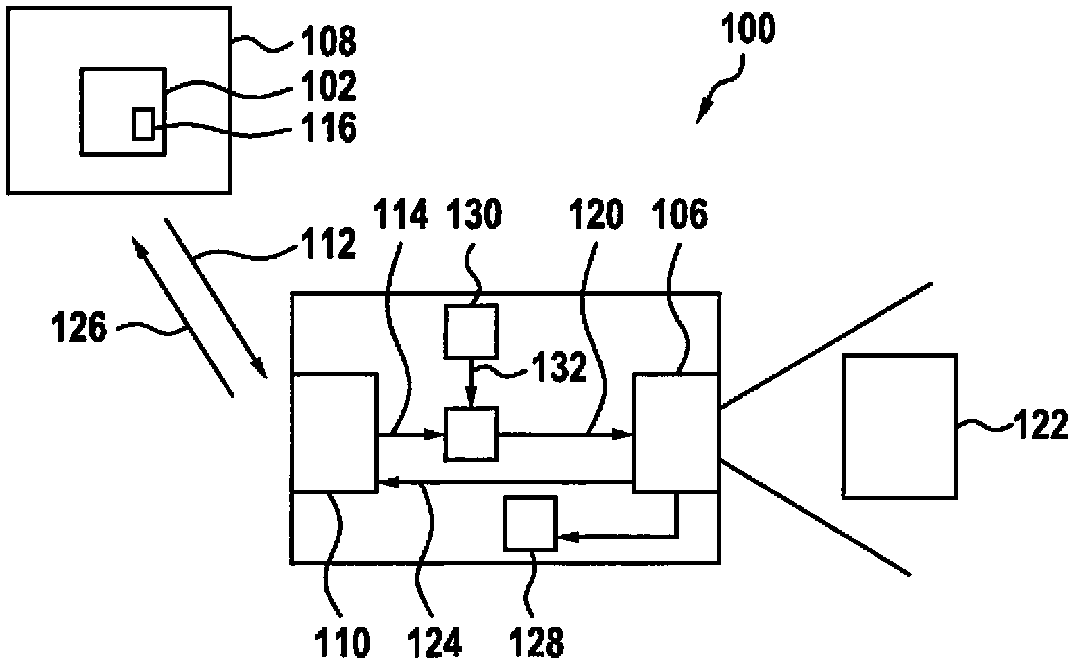
[0024] FIG. 1 shows a schematic illustration of a device 100 for updating a digital map 102 according to one exemplary embodiment.
[0025] Shown is a vehicle 104 which includes a sensor 106, which is used for updating digital map 102 in this exemplary embodiment. According to this exemplary embodiment, digital map 102, or map material on which digital map 102 is based, is stored in a vehicle-external management device 108, e.g., in the form of a server.
[0026] Device 100 includes a read-in device 110, which is developed to read in an update signal 112 which includes an item of information 114 about an area 116 of digital map 102 to be updated. According to this exemplary embodiment, update signal 112 is transmitted to vehicle 104 in a wireless manner. Read-in device 110 is developed to extract from update signal 112 item of information 114 about region 116 to be updated and to make it available to a determination device 118. Determination device 118 is developed to use item of information 114 in order to determine an adjustment signal 120, which is suitable to adjust a detection range of environment sensor 106 in such a way that environment sensor 106 is able to detect and image a section 122 of the environment of vehicle 104 that corresponds to area 116 of digital map 102 to be updated. Environment sensor 106 or a supply device linked to environment sensor 106 is developed to supply area data 124 for updating digital map 102. Area data 124 includes an image of section 122 of the environment of vehicle 104 detected by sensor 106. According to this exemplary embodiment, area data 124, or a signal 126 that includes area data 124 or data derived therefrom, is output to management device 108 via an interface of vehicle 104 and used by management device 108 for updating region 116 of digital map 102 to be updated.
[0027] According to one exemplary embodiment, device 100 only includes determination device 118 and a sensor-internal or sensor-external supply device for the supply of area data 124. According to further exemplary embodiments, device 100 additionally includes read-in device 110 and/or sensor 106 and/or management device 108. In addition to sensor 106, vehicle 104 may include further sensors, which are able to be used in addition or as an alternative to sensor 106 for ascertaining area data 124.
[0028] According to one exemplary embodiment, vehicle 104 includes a driver-assistance system 128, which, for instance, uses data supplied by environment sensor 106 in order to carry out a driving task. According to one exemplary embodiment, device 100 has a checking device, which is developed to check whether driver-assistance system 128 is currently using environment sensor 106 or will use it at a time when section 122 turns up in the detection range of environment sensor 106. If such a use is present, adjustment device 118 is developed not to determine adjustment signal 120, or at least not to supply it, in order to avoid an adverse effect on the operation of driver-assistance system 128.
[0029] According to one exemplary embodiment, vehicle 104 includes a position-determination device 130, which is developed to supply adjustment device 118 with a position signal 132, which includes data pertaining to a position and driving direction or an orientation of vehicle 104.
[0030] Adjustment device 118 is developed to determine adjustment signal 120 with the aid of position signal 132. Adjustment device 118 may use position signal 132 in order to estimate when and in which manner section 122 is able to be detected by environment sensor 106.
[0031] An exemplary embodiment, in which the described approach is used for highly and fully automated systems, will be described in greater detail in the following text. A management device 108 is used, which is developed as a back end server 108, or back end in abbreviated form. The communication of back end server 108 with vehicles such as illustrated vehicle 104 for the selective updating of certain map areas 116 is carried out with the aid of a variable field of view (FOV) of the sensor system of vehicle 104 including at least sensor 106. According to one exemplary embodiment, the field of view is defined by the range and the opening angle of sensor 106.
[0032] Systems for automating a vehicle control may be subdivided into different stages based on their degrees, i.e. from manual to fully automated (see BASt (Bundesanstalt fur Stra enverkehr) classification) (translated as Federal Highway Research Institute). A characteristic of the "partial automation" stage is that the system is able to assume both the linear and transverse control in certain situations and for a certain period of time. The driver must monitor the system on a permanent basis and always be prepared to take full control of the vehicle guidance. Fully automated systems are characterized in that the vehicle is driving autonomously and without intervention on the part of the driver.
[0033] For localization purposes and a situation analysis, fully automated systems require a detailed map 102 of their environment, which is stored on back end server 108, for example, and may be called up by vehicles 104 when the need arises. However, in order to allow for reliable and safe driving, this map 102 should always be kept up-to-date. To set up the map, the described approach advantageously no longer requires that a vehicle equipped with a special reference-sensor system travel the route repeatedly in order to record data that will then be used to generate map 102. Since this map preparation process is very time-consuming and expensive, a different solution is used according to the approach described here.
[0034] After vehicles 104 have been provided with an initial map 102, which was recorded using a reference sensor system, for example, the vehicle-installed sensors 106, which may be embodied as a radar sensor, lidar sensor, video sensor and/or an ultrasonic sensor, for instance, are used to detect deviations between the environment and map 102. These deviations are loaded into back end 108 where they are utilized to update map 102. The possibility of sensor generations that are able to selectively adapt the field of view, i.e. the range and the opening angle, and thus may achieve a higher information density by focusing on certain areas, is exploited in this context.
[0035] The present invention describes a method by which back end 108 is able to selectively instruct vehicles 104 to ascertain information 124 pertaining to certain areas 122 of the vehicle environment with the aid of vehicle sensor system 106. More specifically, the ability of the particular sensors 106 that are able to adjust their field of view in a variable and continuous manner is utilized for this purpose.
[0036] The described approach makes it possible for a back end server 108 that supplies maps 102 for highly automated driving to selectively instruct vehicles 104 to collect information about certain areas in the environment of vehicle 104, if possible. In this way, map 102 is able to be kept up-to-date via the vehicle fleet on the road. An expensive updating via reference vehicles is therefore able to be dispensed with.
[0037] In an advantageous manner, the described approach described offers the possibility of instructing sensors 106 that are not used for the current driving task to adapt their field of view in such a way that areas 122 about which further information is required are illuminated.
[0038] In the process, both sensors 106 which are able to modify their field of view only to a limited extent, i.e. the range and opening angle, and sensors 106 which are able to adapt their field of view in a variable and continuous manner, are able to be utilized.
[0039] Most vehicle actions do not require the information from all environment sensors 106. In the case of a vehicle 104 which, for instance, is equipped with a radar sensor 106 at each corner, only the information from the radar sensors situated on one side will be important during a lane change. Back end 108 is now able to selectively instruct sensors 106 that are not in use to adjust their field of view in such a way that areas 122 about which further information is required are illuminated. For example, in the case of radar sensors 106, an area 122 at a greater distance is able to be illuminated by reducing the opening angle. If information from the near region is of interest, then radar sensor 106 may be instructed to illuminate the broadest possible opening angle.
[0040] Back end 108 informs vehicle 104 of the particular areas 122 of the current route for which further information is required. Based on the current driving action and the number or position of sensors 106 that are not in use just then, vehicle 104 decides on its own whether it is possible to obtain information about these areas 122 in a selective manner. If this is the case, data 124 are transmitted to the back end, where the data is used for updating map 102.
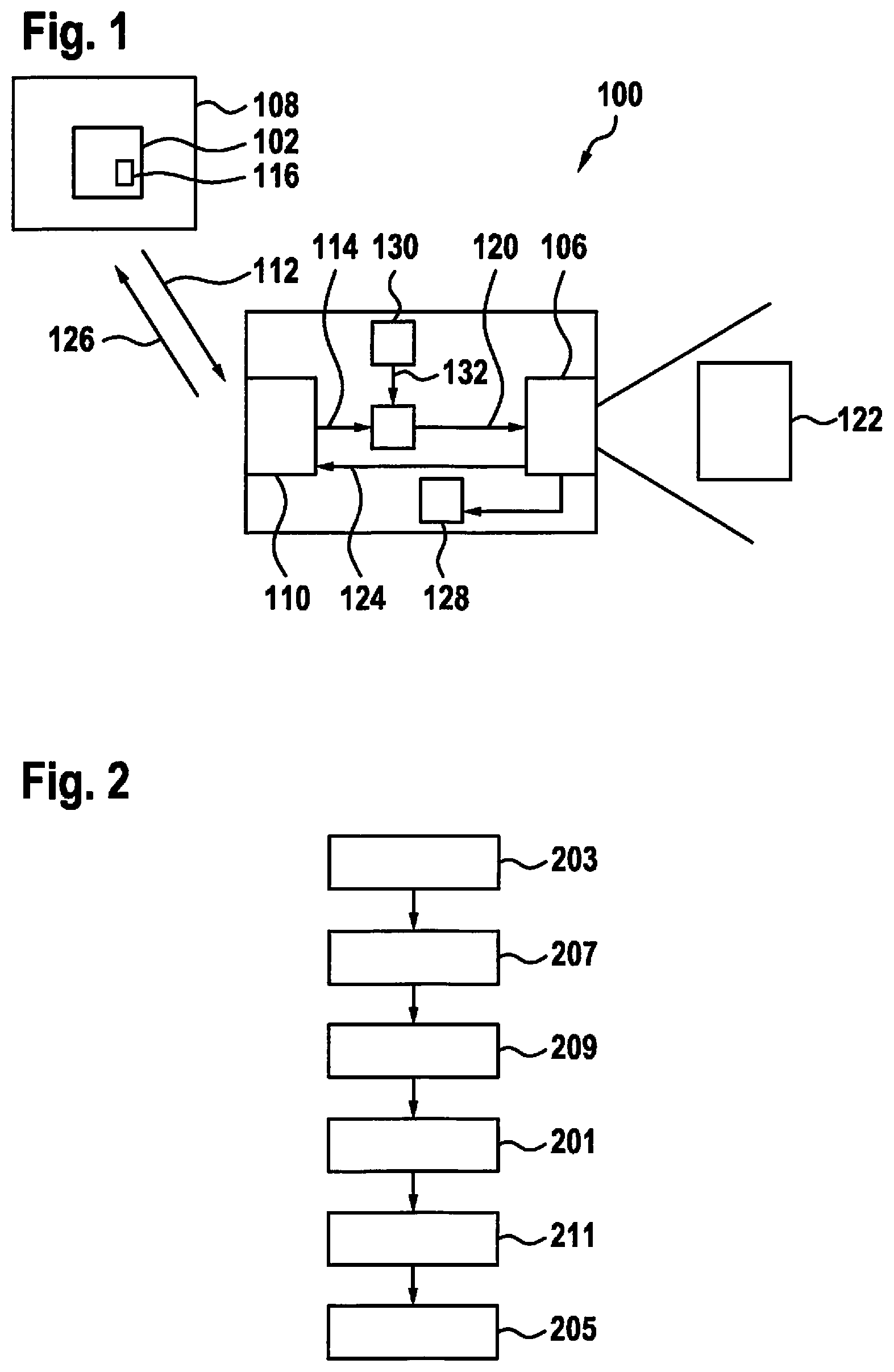
[0041] FIG. 2 shows a flow diagram of a method for updating a digital map for vehicle navigation according to one exemplary embodiment. The present method is able to be carried out using the device, or some of the devices, described with the aid of FIG. 1.
[0042] In a step 201, an adjustment signal is determined, which is suitable to adjust a detection range of an environment sensor of a vehicle to a section of an environment of the vehicle that corresponds to an area of the digital map to be updated. An item of information about the area to be updated is used in the process. In a step 203, the information is optionally read in in the form of an update signal that includes the information. Based on an image of the section of the environment detected by the environment sensor, area data are supplied in a step 205, which may be used for updating the digital map.
[0043] In a step 207, the information about the area to be updated is optionally used for selecting a suitable environment sensor from among a plurality of sensors of the vehicle. Also optionally, it is checked in a step 209 whether the environment sensor is required by a driver-assistance system. Depending on whether or not the environment sensor is indeed required, the determination of the adjustment signal is either executed or not executed in step 201.
[0044] According to one exemplary embodiment, the present method furthermore includes a step 211 in which the area data supplied in step 205 are detected with the aid of the environment sensor.
[0045] If an exemplary embodiment includes an "and/or" linkage between a first feature and a second feature, then this should be read as indicating that the exemplary embodiment according to one embodiment includes both the first feature and the second feature and according to a further embodiment, includes either only the first feature or only the second feature.
* * * * *
D00000
D00001
XML
uspto.report is an independent third-party trademark research tool that is not affiliated, endorsed, or sponsored by the United States Patent and Trademark Office (USPTO) or any other governmental organization. The information provided by uspto.report is based on publicly available data at the time of writing and is intended for informational purposes only.
While we strive to provide accurate and up-to-date information, we do not guarantee the accuracy, completeness, reliability, or suitability of the information displayed on this site. The use of this site is at your own risk. Any reliance you place on such information is therefore strictly at your own risk.
All official trademark data, including owner information, should be verified by visiting the official USPTO website at www.uspto.gov. This site is not intended to replace professional legal advice and should not be used as a substitute for consulting with a legal professional who is knowledgeable about trademark law.