Location Based Tracking
Forstall; Scott ; et al.
U.S. patent application number 16/672361 was filed with the patent office on 2020-04-30 for location based tracking. The applicant listed for this patent is Apple Inc.. Invention is credited to Robert E. Borchers, Irman A. Chaudhri, Gregory N. Christie, Scott Forstall.
| Application Number | 20200132468 16/672361 |
| Document ID | / |
| Family ID | 40160563 |
| Filed Date | 2020-04-30 |


| United States Patent Application | 20200132468 |
| Kind Code | A1 |
| Forstall; Scott ; et al. | April 30, 2020 |
Location Based Tracking
Abstract
Location information is used to build a database of locations having associated audio, video, image, or text data. In some implementations, a device includes a touch-sensitive display and collects data associated with a geographic location of interest. The geographic location of interest can be displayed on a map using an indicator. A touch selection of the indicator provides access to the data through an interface displayed on the touch-sensitive display. One or more locations of interest can be displayed and grouped together by an attribute.
| Inventors: | Forstall; Scott; (Mountain View, CA) ; Christie; Gregory N.; (San Jose, CA) ; Borchers; Robert E.; (Pleasanton, CA) ; Chaudhri; Irman A.; (San Francisco, CA) | ||||||||||
| Applicant: |
|
||||||||||
|---|---|---|---|---|---|---|---|---|---|---|---|
| Family ID: | 40160563 | ||||||||||
| Appl. No.: | 16/672361 | ||||||||||
| Filed: | November 1, 2019 |
Related U.S. Patent Documents
| Application Number | Filing Date | Patent Number | ||
|---|---|---|---|---|
| 15857050 | Dec 28, 2017 | 10508921 | ||
| 16672361 | ||||
| 15070613 | Mar 15, 2016 | 9891055 | ||
| 15857050 | ||||
| 14584747 | Dec 29, 2014 | 9310206 | ||
| 15070613 | ||||
| 13361897 | Jan 30, 2012 | 8924144 | ||
| 14584747 | ||||
| 12164866 | Jun 30, 2008 | 8108144 | ||
| 13361897 | ||||
| 60946813 | Jun 28, 2007 | |||
| Current U.S. Class: | 1/1 |
| Current CPC Class: | H04M 1/72522 20130101; H04M 2250/10 20130101; G06F 16/29 20190101; H04M 2250/12 20130101; H04M 2250/22 20130101; H04W 4/029 20180201; G01C 21/00 20130101; G01C 21/20 20130101; G06F 3/0482 20130101; H04M 1/72572 20130101 |
| International Class: | G01C 21/20 20060101 G01C021/20; H04M 1/725 20060101 H04M001/725; G06F 3/0482 20060101 G06F003/0482; G01C 21/00 20060101 G01C021/00; H04W 4/029 20060101 H04W004/029; G06F 16/29 20060101 G06F016/29 |
Claims
1-21. (canceled)
22. A method, comprising: receiving, at a first mobile device, user input requesting data associated with a specified geographic location in the geographic region; transmitting, to a remote storage location, a request for data objects associated with the specified geographic location; receiving, from the remote storage location, at least one data object associated with the specified geographic location, wherein the at least one data object is at least one of an image data object, a video data object, or a text data object, wherein the at least one data object is stored at the remote storage location in association with data representing the specified geographic location; and displaying, on the first mobile device, one or more user interface elements enabling a user to access the at least one data object.
23. The method of claim 22, wherein the one or more user interface elements include at least one of: a user interface element for accessing at least one image data object, a user interface element for accessing at least one video data object, and a user interface element for accessing at least one text data object.
24. The method of claim 22, wherein receiving the user input comprises receiving an input to capture an image associated with the specified geographic location.
25. The method of claim 24, comprising: determining the specified geographic location based on coded data associated with the image.
26. The method of claim 25, comprising: presenting, on the user interface of the mobile device, one or more user interface elements enabling a user to generate data and access locally stored data, wherein the data includes one or more of text, images, or video; receiving, at the mobile device, user input representing an instruction to perform an action comprising at least one of generating data and accessing locally stored data; associating the at least one of the generated data and accessed locally stored data with the data representing the geographic location; and storing, on the mobile device, data representing the association of the specified geographic location and the selected data.
27. The method of claim 22, comprising displaying, in the user interface, a representation of the specified geographic location in association with the one or more user interface elements.
28. The method of claim 27, wherein the representation comprises a street address associated with the specified geographical location or a map of the specified geographic location.
29. A non-transitory computer-readable medium including one or more sequences of instructions which, when executed by one or more processors, causes operations comprising: receiving, at a first mobile device, user input requesting data associated with a specified geographic location in the geographic region; transmitting, to a remote storage location, a request for data objects captured associated with the specified geographic location; receiving, from the remote storage location, at least one data object associated with the specified geographic location, wherein the at least one data object is at least one of an image data object, a video data object, or a text data object, wherein the at least one data object is stored at the remote storage location in association with data representing the specified geographic location; and displaying, on the first mobile device, one or more user interface elements enabling a user to access the at least one data object.
30. The non-transitory computer-readable medium of claim 29, wherein the one or more user interface elements include at least one of: a user interface element for accessing at least one image data object, a user interface element for accessing at least one video data object, and a user interface element for accessing at least one text data object.
31. The non-transitory computer-readable medium of claim 29, wherein receiving the user input comprises receiving an input to capture an image associated with the specified geographic location.
32. The non-transitory computer-readable medium of claim 31, the operations comprising: determining the specified geographic location based on coded data associated with the image.
33. The non-transitory computer-readable medium of claim 32, the operations comprising: presenting, on the user interface of the mobile device, one or more user interface elements enabling a user to generate data and access locally stored data, wherein the data includes one or more of text, images, or video; receiving, at the mobile device, user input representing an instruction to perform an action comprising at least one of generating data and accessing locally stored data; associating the at least one of the generated data and accessed locally stored data with the data representing the geographic location; and storing, on the mobile device, data representing the association of the specified geographic location and the selected data.
34. The non-transitory computer-readable medium of claim 29, the operations comprising displaying, in the user interface, a representation of the specified geographic location in association with the one or more user interface elements.
35. The non-transitory computer-readable medium of claim 34, wherein the representation comprises a street address associated with the specified geographical location or a map of the specified geographic location.
36. A system comprising: one or more processors; and a non-transitory computer-readable medium including one or more sequences of instructions which, when executed by the one or more processors, causes operations comprising: receiving, at the first mobile device, user input requesting data associated with a specified geographic location in the geographic region; transmitting, to a remote storage location, a request for data objects associated with the specified geographic location; receiving, from the remote storage location, at least one data object associated with the specified geographic location, wherein the at least one data object is at least one of an image data object, a video data object, or a text data object, wherein the at least one data object is stored at the remote storage location in association with data representing the specified geographic location; and displaying, on the first mobile device, one or more user interface elements enabling a user to access the at least one data object.
37. The system of claim 36, wherein the one or more user interface elements include at least one of: a user interface element for accessing at least one image data object, a user interface element for accessing at least one video data object, and a user interface element for accessing at least one text data object.
38. The system of claim 36, wherein receiving the user input comprises receiving an input to capture an image associated with the specified geographic location.
39. The system of claim 38, the operations comprising: determining the specified geographic location based on coded data associated with the image.
40. The system of claim 39, the operations comprising: presenting, on the user interface of the mobile device, one or more user interface elements enabling a user to generate data and access locally stored data, wherein the data includes one or more of text, images, or video; receiving, at the mobile device, user input representing an instruction to perform an action comprising at least one of generating data and accessing locally stored data; associating the at least one of the generated data and accessed locally stored data with the data representing the geographic location; and storing, on the mobile device, data representing the association of the specified geographic location and the selected data.
41. The system of claim 36, the operations comprising displaying, in the user interface, a representation of the specified geographic location in association with the one or more user interface elements, wherein the representation of the specified geographic location comprises a map of the specified geographic location or a street address associated with the specified geographic location.
Description
CROSS-REFERENCE TO RELATED APPLICATIONS
[0001] This application is a continuation of U.S. patent application Ser. No. 15/857,050, filed on Dec. 28, 2017, and entitled "LOCATION BASED TRACKING", which is a continuation of U.S. patent application Ser. No. 15/070,613, filed on Mar. 15, 2016, and entitled "LOCATION BASED TRACKING", which is a continuation of U.S. patent application Ser. No. 14/584,747, filed Dec. 29, 2014, and entitled "LOCATION BASED TRACKING," which is a continuation of U.S. patent application Ser. No. 13/361,897, filed Jan. 30, 2012, and entitled "LOCATION BASED TRACKING," which is a continuation of U.S. patent application Ser. No. 12/164,866, filed Jun. 30, 2008, and entitled "LOCATION BASED TRACKING," which claims priority to U.S. Provisional Patent Application Ser. No. 60/946,813 filed Jun. 28, 2007, and entitled "LOCATION BASED TRACKING," the contents of each of which are incorporated herein by reference.
TECHNICAL FIELD
[0002] The subject matter of this patent application is generally related to location based services.
BACKGROUND
[0003] Mobile devices have grown more powerful and feature-rich and now include such features as personal digital assistant (PDA) capabilities, cameras to capture video and still images, Internet access, etc. Location-based services have been developed for determining and tracking the locations of the users of mobile devices. Location-based services provide location-specific information to mobile devices, including, for example, global positioning system (GPS) data to locate the mobile device on a map of a geographic region.
[0004] A number of applications are available for aiding users in navigation and route planning. Some of these applications use mobile devices containing global positioning systems to define the location of the mobile device and plan a route to a desired destination. Currently, however, these route planning systems do not provide a way to document items of interest to a user while a route is traveled. In conventional systems, the information the route planning systems provide is limited to what is pre-programmed. This information can become obsolete in time and may be of little or no interest to the user.
SUMMARY
[0005] Location information is used to build a database of locations having associated audio, video, image or text data.
[0006] In some implementations, a method includes: presenting a map of a geographic region on a touch-sensitive display; receiving touch input selecting a geographic location; determining geographic positioning information of the geographic location; receiving data in response to an input received by a touch-sensitive display; associating the data with the geographic positioning information of the geographic location to produce geographically tagged data; and storing the geographically-tagged data.
[0007] In some implementations a method includes: presenting indications of a predetermined group of geographic locations on a touch-sensitive display; receiving a selection of a geographic location from the group of geographic locations displayed on the touch-sensitive display; and presenting geographically tagged data associated with the geographic location in a user interface on the touch-sensitive display.
[0008] In some implementations, a user interface includes a touch-sensitive display area for displaying indications of a predetermined group of geographic locations associated by an attribute, wherein each indication represents geographically coded data associated with a geographic position, and wherein a name of the attribute is displayed in the user interface.
[0009] Other implementations are disclosed, including implementations directed to systems, methods, apparatuses, computer-readable mediums and user interfaces.
DESCRIPTION OF DRAWINGS
[0010] FIG. 1 is a block diagram of an example mobile device.
[0011] FIG. 2 is a block diagram of an example network operating environment for the mobile device of FIG. 1.
[0012] FIG. 3 is a block diagram of an example implementation of the mobile device of FIG. 1.
[0013] FIGS. 4-10 are exemplary interfaces to input, review and display data associated with geographic locations of interest.
[0014] FIG. 11 is a flow diagram of an example process for indicating geographic locations of interest.
[0015] FIG. 12 is a flow diagram of an example process for reviewing and editing data associated with geographic locations of interest.
[0016] FIG. 13 is a flow diagram of an example process for interactively displaying data associated with geographic locations of interest.
[0017] FIG. 14 is a flow diagram of an example process for playback of data associated with geographic locations of interest.
DETAILED DESCRIPTION
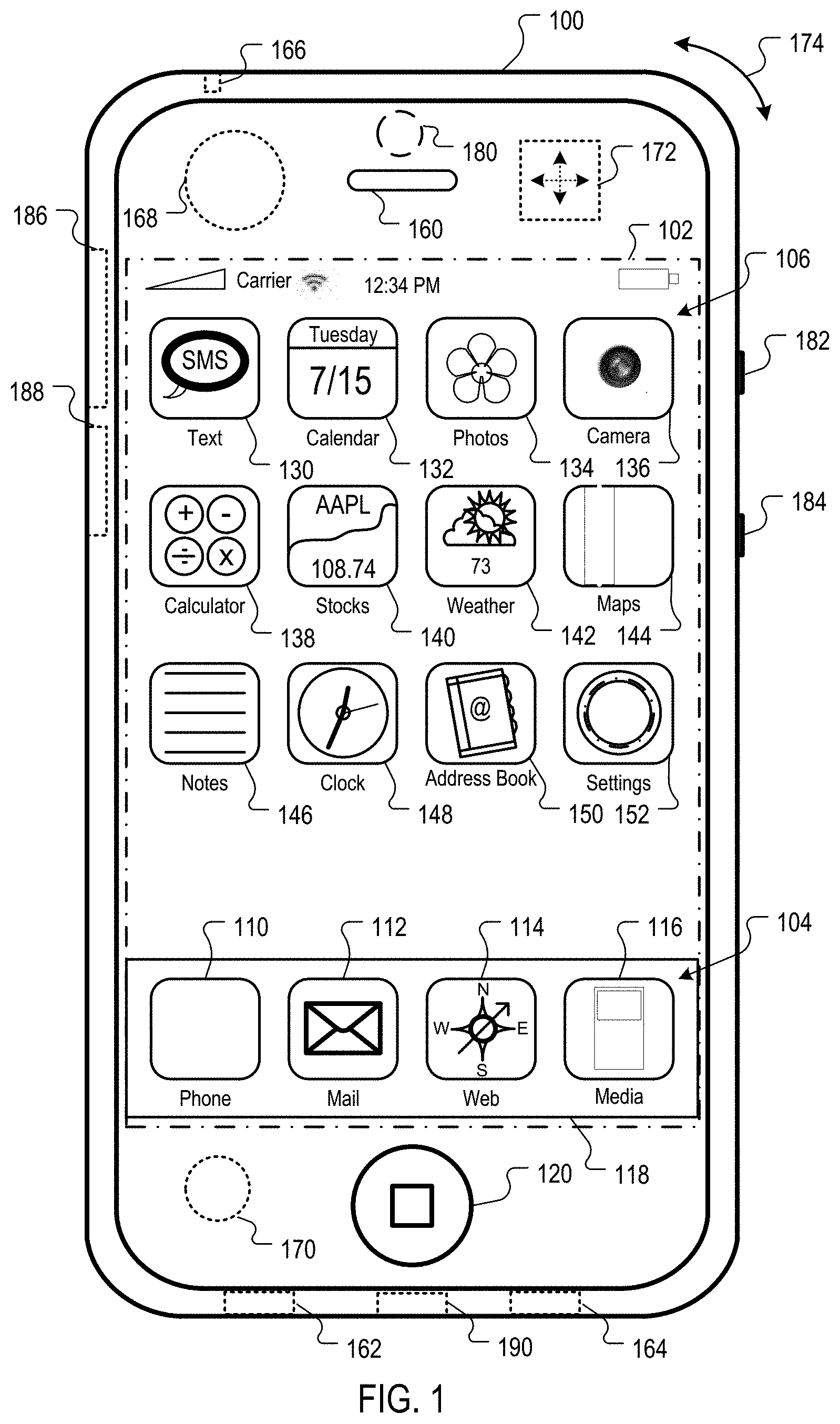
[0018] FIG. 1 is a block diagram of an example mobile device 100. The mobile device 100 can be, for example, a handheld computer, a personal digital assistant, a cellular telephone, a network appliance, a camera, a smart phone, an enhanced general packet radio service (EGPRS) mobile phone, a network base station, a media player, a navigation device, an email device, a game console, or other electronic device, a combination of any two or more of these data processing devices or other data processing devices.
Mobile Device Overview
[0019] In some implementations, the mobile device 100 includes a touch-sensitive display 102. The touch-sensitive display 102 can implement liquid crystal display (LCD) technology, light emitting polymer display (LPD) technology, or some other display technology. The touch-sensitive display 102 can be sensitive to haptic and/or tactile contact with a user.
[0020] In some implementations, the touch-sensitive display 102 can comprise a multi-touch-sensitive display 102. A multi-touch-sensitive display 102 can, for example, process multiple simultaneous touch points, including processing data related to the pressure, degree and/or position of each touch point. Such processing facilitates gestures and interactions with multiple fingers, chording, and other interactions. Other touch-sensitive display technologies can also be used, e.g., a display in which contact is made using a stylus or other pointing device. Some examples of multi-touch-sensitive display technology are described in U.S. Pat. Nos. 6,323,846, 6,570,557, 6,677,932, and U.S. Patent Publication 2002/0015024A1, each of which is incorporated by reference herein in its entirety.
[0021] In some implementations, the mobile device 100 can display one or more graphical user interfaces on the touch-sensitive display 102 for providing the user access to various system objects and for conveying information to the user. In some implementations, the graphical user interface can include one or more display objects 104, 106. In the example shown, the display objects 104, 106, are graphic representations of system objects. Some examples of system objects include device functions, applications, windows, files, alerts, events, or other identifiable system objects.
Exemplary Mobile Device Functionality
[0022] In some implementations, the mobile device 100 can implement multiple device functionalities, such as a telephony device, as indicated by a phone object 110; an e-mail device, as indicated by the e-mail object 112; a network data communication device, as indicated by the Web object 114; a Wi-Fi base station device (not shown); and a media processing device, as indicated by the media player object 116. In some implementations, particular display objects 104, e.g., the phone object 110, the e-mail object 112, the Web object 114, and the media player object 116, can be displayed in a menu bar 118. In some implementations, device functionalities can be accessed from a top-level graphical user interface, such as the graphical user interface illustrated in FIG. 1. Touching one of the objects 110, 112, 114 or 116 can, for example, invoke corresponding functionality.
[0023] In some implementations, the mobile device 100 can implement network distribution functionality. For example, the functionality can enable the user to take the mobile device 100 and its associated network while traveling. In particular, the mobile device 100 can extend Internet access (e.g., Wi-Fi) to other wireless devices in the vicinity. For example, mobile device 100 can be configured as a base station for one or more devices. As such, mobile device 100 can grant or deny network access to other wireless devices.
[0024] In some implementations, upon invocation of device functionality, the graphical user interface of the mobile device 100 changes, or is augmented or replaced with another user interface or user interface elements, to facilitate user access to particular functions associated with the corresponding device functionality. For example, in response to a user touching the phone object 110, the graphical user interface of the touch-sensitive display 102 may present display objects related to various phone functions; likewise, touching of the email object 112 may cause the graphical user interface to present display objects related to various e-mail functions; touching the Web object 114 may cause the graphical user interface to present display objects related to various Web-surfing functions; and touching the media player object 116 may cause the graphical user interface to present display objects related to various media processing functions.
[0025] In some implementations, the top-level graphical user interface environment or state of FIG. 1 can be restored by pressing a button 120 located near the bottom of the mobile device 100. In some implementations, each corresponding device functionality may have corresponding "home" display objects displayed on the touch-sensitive display 102, and the graphical user interface environment of FIG. 1 can be restored by pressing the "home" display object.
[0026] In some implementations, the top-level graphical user interface can include additional display objects 106, such as a short messaging service (SMS) object 130, a calendar object 132, a photos object 134, a camera object 136, a calculator object 138, a stocks object 140, a weather object 142, a maps object 144, a notes object 146, a clock object 148, an address book object 150, and a settings object 152. Touching the SMS display object 130 can, for example, invoke an SMS messaging environment and supporting functionality; likewise, each selection of a display object 132, 134, 136, 138, 140, 142, 144, 146, 148, 150 and 152 can invoke a corresponding object environment and functionality.
[0027] Additional and/or different display objects can also be displayed in the graphical user interface of FIG. 1. For example, if the device 100 is functioning as a base station for other devices, one or more "connection" objects may appear in the graphical user interface to indicate the connection. In some implementations, the display objects 106 can be configured by a user, e.g., a user may specify which display objects 106 are displayed, and/or may download additional applications or other software that provides other functionalities and corresponding display objects.
[0028] In some implementations, the mobile device 100 can include one or more input/output (I/O) devices and/or sensor devices. For example, a speaker 160 and a microphone 162 can be included to facilitate voice-enabled functionalities, such as phone and voice mail functions. In some implementations, a loud speaker 164 can be included to facilitate hands-free voice functionalities, such as speaker phone functions. An audio jack 166 can also be included for use of headphones and/or a microphone.
[0029] In some implementations, a proximity sensor 168 can be included to facilitate the detection of the user positioning the mobile device 100 proximate to the user's ear and, in response, to disengage the touch-sensitive display 102 to prevent accidental function invocations. In some implementations, the touch-sensitive display 102 can be turned off to conserve additional power when the mobile device 100 is proximate to the user's ear.
[0030] Other sensors can also be used. For example, in some implementations, an ambient light sensor 170 can be utilized to facilitate adjusting the brightness of the touch-sensitive display 102. In some implementations, an accelerometer 172 can be utilized to detect movement of the mobile device 100, as indicated by the directional arrow 174. Accordingly, display objects and/or media can be presented according to a detected orientation, e.g., portrait or landscape. In some implementations, the mobile device 100 may include circuitry and sensors for supporting a location determining capability, such as that provided by the global positioning system (GPS) or other positioning systems (e.g., systems using Wi-Fi access points, television signals, cellular grids, Uniform Resource Locators (URLs)). In some implementations, a positioning system (e.g., a GPS receiver) can be integrated into the mobile device 100 or provided as a separate device that can be coupled to the mobile device 100 through an interface (e.g., port device 190) to provide access to location-based services.
[0031] The mobile device 100 can also include a camera lens and sensor 180. In some implementations, the camera lens and sensor 180 can be located on the back surface of the mobile device 100. The camera can capture still images and/or video.
[0032] The mobile device 100 can also include one or more wireless communication subsystems, such as an 802.11b/g communication device 186, and/or a Bluetooth.TM. communication device 188. Other communication protocols can also be supported, including other 802.x communication protocols (e.g., WiMAX, Wi-Fi, 3G), code division multiple access (CDMA), global system for mobile communications (GSM), Enhanced Data GSM Environment (EDGE), etc.
[0033] In some implementations, a port device 190, e.g., a Universal Serial Bus (USB) port, or a docking port, or some other wired port connection, can be included. The port device 190 can, for example, be utilized to establish a wired connection to other computing devices, such as other communication devices 100, network access devices, a personal computer, a printer, or other processing devices capable of receiving and/or transmitting data. In some implementations, the port device 190 allows the mobile device 100 to synchronize with a host device using one or more protocols, such as, for example, the TCP/IP, HTTP, UDP and any other known protocol. In some implementations, a TCP/IP over USB protocol can be used.
Network Operating Environment
[0034] FIG. 2 is a block diagram of an example network operating environment 200 for the mobile device 100 of FIG. 1. The mobile device 100 of FIG. 1 can, for example, communicate over one or more wired and/or wireless networks 210 in data communication. For example, a wireless network 212, e.g., a cellular network, can communicate with a wide area network (WAN) 214, such as the Internet, by use of a gateway 216. Likewise, an access point 218, such as an 802.11g wireless access point, can provide communication access to the wide area network 214. In some implementations, both voice and data communications can be established over the wireless network 212 and the access point 218. For example, the mobile device 100a can place and receive phone calls (e.g., using VoIP protocols), send and receive e-mail messages (e.g., using POP3 protocol), and retrieve electronic documents and/or streams, such as web pages, photographs, and videos, over the wireless network 212, gateway 216, and wide area network 214 (e.g., using TCP/IP or UDP protocols). Likewise, the mobile device 100b can place and receive phone calls, send and receive e-mail messages, and retrieve electronic documents over the access point 218 and the wide area network 214. In some implementations, the mobile device 100 can be physically connected to the access point 218 using one or more cables and the access point 218 can be a personal computer. In this configuration, the mobile device 100 can be referred to as a "tethered" device.
[0035] The mobile devices 100a and 100b can also establish communications by other means. For example, the wireless device 100a can communicate with other wireless devices, e.g., other wireless devices 100, cell phones, etc., over the wireless network 212. Likewise, the mobile devices 100a and 100b can establish peer-to-peer communications 220, e.g., a personal area network, by use of one or more communication subsystems, such as the Bluetooth.TM. communication device 188 shown in FIG. 1. Other communication protocols and topologies can also be implemented.
[0036] The mobile device 100 can, for example, communicate with one or more services 230, 240, 250, and 260 and/or one or more content publishers 270 over the one or more wired and/or wireless networks 210. For example, a navigation service 230 can provide navigation information, e.g., map information, location information, route information, and other information, to the mobile device 100. In the example shown, a user of the mobile device 100b has invoked a map functionality, e.g., by pressing the maps object 144 on the top-level graphical user interface shown in FIG. 1, and has requested and received a map for the location "1 Infinite Loop, Cupertino, Calif."
[0037] User devices 280 can, for example, communicate with the one or more services 230, 240, 250 and 260 and/or one or more content publishes 260 over the one or more wired and/or wireless networks 210 to access content and services as well as communicate with the mobile device 100. The user devices 280 can be, for example, a personal computer, a set top, a gaming device, a digital video recorder, a portable audio or video player, an in-vehicle navigation system, etc.
[0038] A messaging service 240 can, for example, provide e-mail and/or other messaging services. A media service 250 can, for example, provide access to media files, such as song files, movie files, video clips, and other media data. One or more other services 260 can also be utilized by the mobile device 100.
[0039] The mobile device 100 can also access other data and content over the one or more wired and/or wireless networks 210. For example, content publishers, e.g., content publisher(s) 270, such as news sites, RSS feeds, web sites, blogs, social networking sites, developer networks, etc., can be accessed by the mobile device 100. Such access can be provided by invocation of a web browsing function or application (e.g., a browser) in response to a user touching the Web object 114.
Exemplary Mobile Device Architecture
[0040] FIG. 3 is a block diagram 300 of an example implementation of the mobile device 100 of FIG. 1. The mobile device 100 can include a memory interface 302, one or more data processors, image processors and/or central processing units 304, and a peripherals interface 306. The memory interface 302, the one or more processors 304 and/or the peripherals interface 306 can be separate components or can be integrated in one or more integrated circuits. The various components in the mobile device 100 can be coupled by one or more communication buses or signal lines.
[0041] Sensors, devices and subsystems can be coupled to the peripherals interface 306 to facilitate multiple functionalities. For example, a motion sensor 310, a light sensor 312, and a proximity sensor 314 can be coupled to the peripherals interface 306 to facilitate the orientation, lighting and proximity functions described with respect to FIG. 1. Other sensors 316 can also be connected to the peripherals interface 306, such as a positioning system (e.g., GPS receiver), a temperature sensor, a biometric sensor, or other sensing device, to facilitate related functionalities.
[0042] A camera subsystem 320 and an optical sensor 322, e.g., a charged coupled device (CCD) or a complementary metal-oxide semiconductor (CMOS) optical sensor, can be utilized to facilitate camera functions, such as recording photographs and video clips.
[0043] Communication functions can be facilitated through one or more wireless communication subsystems 324, which can include radio frequency receivers and transmitters and/or optical (e.g., infrared) receivers and transmitters. The specific design and implementation of the communication subsystem 324 can depend on the communication network(s) over which the mobile device 100 is intended to operate. For example, a mobile device 100 may include communication subsystems 324 designed to operate over a GSM network, a GPRS network, an EDGE network, a Wi-Fi or WiMAX network, and a Bluetooth.TM. network. In particular, the wireless communication subsystems 324 may include hosting protocols such that the device 100 may be configured as a base station for other wireless devices.
[0044] An audio subsystem 326 can be coupled to a speaker 328 and a microphone 330 to facilitate voice-enabled functions, such as voice recognition, voice replication, digital recording, and telephony functions.
[0045] The I/O subsystem 340 can include a touch screen controller 342 and/or other input controller(s) 344. The touch-screen controller 342 can be coupled to a touch screen 346. The touch screen 346 and touch screen controller 342 can, for example, detect contact and movement or break thereof using any of a plurality of touch sensitivity technologies, including but not limited to capacitive, resistive, infrared, and surface acoustic wave technologies, as well as other proximity sensor arrays or other elements for determining one or more points of contact with the touch screen 346.
[0046] The other input controller(s) 344 can be coupled to other input/control devices 348, such as one or more buttons, rocker switches, thumb-wheel, infrared port, USB port, and/or a pointer device such as a stylus. The one or more buttons (not shown) can include an up/down button for volume control of the speaker 328 and/or the microphone 330.
[0047] In one implementation, a pressing of the button for a first duration may disengage a lock of the touch screen 346; and a pressing of the button for a second duration that is longer than the first duration may turn power to the mobile device 100 on or off. The user may be able to customize a functionality of one or more of the buttons. The touch screen 346 can, for example, also be used to implement virtual or soft buttons and/or a keyboard.
[0048] In some implementations, the mobile device 100 can present recorded audio and/or video files, such as MP3, AAC, and MPEG files. In some implementations, the mobile device 100 can include the functionality of an MP3 player, such as an iPod.TM.. The mobile device 100 may, therefore, include a 36-pin connector that is compatible with the iPod. Other input/output and control devices can also be used.
[0049] The memory interface 302 can be coupled to memory 350. The memory 350 can include high-speed random access memory and/or non-volatile memory, such as one or more magnetic disk storage devices, one or more optical storage devices, and/or flash memory (e.g., NAND, NOR). The memory 350 can store an operating system 352, such as Darwin, RTXC, LINUX, UNIX, OS X, WINDOWS, or an embedded operating system such as VxWorks. The operating system 352 may include instructions for handling basic system services and for performing hardware dependent tasks. In some implementations, the operating system 352 can be a kernel (e.g., UNIX kernel).
[0050] The memory 350 may also store communication instructions 354 to facilitate communicating with one or more additional devices, one or more computers and/or one or more servers. The memory 350 may include graphical user interface instructions 356 to facilitate graphic user interface processing; sensor processing instructions 358 to facilitate sensor-related processing and functions; phone instructions 360 to facilitate phone-related processes and functions; electronic messaging instructions 362 to facilitate electronic-messaging related processes and functions; web browsing instructions 364 to facilitate web browsing-related processes and functions; media processing instructions 366 to facilitate media processing-related processes and functions; GPS/Navigation instructions 368 to facilitate GPS and navigation-related processes and instructions; camera instructions 370 to facilitate camera-related processes and functions; and/or other software instructions 372 to facilitate other processes and functions.
[0051] Each of the above identified instructions and applications can correspond to a set of instructions for performing one or more functions described above. These instructions need not be implemented as separate software programs, procedures or modules. The memory 350 can include additional instructions or fewer instructions. Furthermore, various functions of the mobile device 100 may be implemented in hardware and/or in software, including in one or more signal processing and/or application specific integrated circuits.
[0052] FIG. 4 is an example user interface that is presented on the mobile device 100 in response to a user selection of, e.g., the maps object 144. The user interface includes an information display area 400 and a map display area 402. A position of the mobile device is indicated by an indicator 404. The information display area 400 receives user input from the touch-sensitive display 102. In some implementations, upon an input of a location, e.g., California, the user is presented with an object 408 providing an option to save data associated with the input location.
[0053] In some implementations, the user provides a "friendly name" to identify the location or group of locations of interest. If, for example, a user would like to save data related to a trip to California, the user can identify the data by entering, e.g., "My Trip to California" into the display area 400. A user can save the data in accordance with any attribute.
[0054] In some implementations, an indicator 406 can be placed on the map display area 402 to indicate a particular geographic location of interest. For example, if the location if interest is in Cupertino, user input can be received from the touch sensitive display 102 to place the indicator 406 on the map display area 402 at either the current location of the mobile device 100 (shown as reference numeral 404) or a user-specified location.
[0055] Where the current location of the mobile device 100 is used to specify the geographic location of interest, according to some implementations, geographic position information can be provided to the mobile device 100 from, for example, Global Positioning System (GPS) coordinate data. The GPS coordinate data can be processed by the GPS/Navigation instructions 368 and can be provided from an external or internal GPS navigation system. Triangulation and external GPS information can be provided to the mobile device 100 through the wireless communication subsystems 324 or port device 190.
[0056] In some implementations, the geographic information regarding the geographic location of interest is manually input by the user. The user can input a street address, a latitude/longitude pair, or other identifying geographic information to specify the geographic location of interest.
[0057] After a geographic location of interest has been indicated, in some implementations, an example user interface 500 shown in FIG. 5 is presented on the mobile device 100 in response to invoking the camera object 136. A next object 502 and back object 504, are provided to navigate within the user interface 500. A save object 506 and delete object 508 are provided to operate on pictures captured by the mobile device 100. In some implementations, audio data is captured as the picture data is captured by the mobile device 100.
[0058] In some implementations, pictures captured by the mobile device are geographically associated with the geographic location of interest when the save object 506 is selected to save the currently displayed picture. In some implementations, the geographic association is automatically performed using the determined position of the mobile device. In some implementations, the geographic association is manually input by a user when touching the save object 506 on the touch-sensitive display 102.
[0059] In some implementations, the association of geographic information with data is performed by geo-tagging the data. For example, geographic position information (e.g., latitude and longitude), geographic place names, or geographical regions are associated with the data. In the example of FIG. 5, the geographic information could be, for example, latitude 37.331837, longitude -122.030799; or 1 Infinite Loop, Cupertino, Calif., USA. In some implementations, the geographic information can be included as meta tags in a document.
[0060] In some implementations, the user interface 500 can be used to capture video when the camera object 136 is invoked by a user. The video data is saved on the mobile device 100 with associated geographic information as described above with regard to pictures data.
[0061] Referring to FIG. 6, notes (e.g., text information or audio information) about the geographic location of interest can be recorded using the notes object 146. The next object 502 and back object 504, are provided to navigate within the user interface 600. The save object 506 and delete object 508 are provided to operate on the notes entered on the mobile device 100. In the manner described above, notes received by the mobile device 100 are geographically associated with the geographic location of interest when the save object 506 is selected to save the current notes on the mobile device 100.
[0062] In some implementations, touching the indicator 406 presents a menu item to invoke a reviewing user interface 700 such as shown in FIG. 7. Objects such as view notes 702, view pictures 704 and view video 706 can be displayed on the user interface 700. If, for example, the view notes object 702 is selected the user interface of FIG. 6 can be displayed. If, for example, the view pictures object 704 or the view videos object 706 is selected, the user interface of FIG. 5 can be displayed. A navigation object 708 is provided, for example, to return to the previous display (e.g., map display area 402 shown in FIG. 4).
[0063] As shown in FIG. 8, in some implementations, multiple indicators 406, 800, 802, 804 and 806 can be placed on the map display area 402 to indicate multiple locations of interest. In some implementations, for each geographic location of interest, the user can capture data such as, pictures, notes, audio and video and save it to the mobile device 100 with an association to the geographic location of interest as described above with regard to indicator 406. In the example interface of FIG. 8, data associated with Palo Alto, Calif. (indicator 800) and San Francisco, Calif. (indicators 802, 804 and 806) is saved on the mobile device 100.
[0064] In some implementations the data associated with the geographic locations identified by indicators 800, 802, 804 and/or 806 can be reviewed in the reviewing user interface 700 of FIG. 7 in response to a selection of indicators 800, 802, 804 and/or 806. For example, if indicator 800 is selected, the user interface 700 is presented, however, the information display area 400 would indicate "Stanford University." Likewise, if indicator 802, 804 or 806 is selected, the information display area 400 would indicate "San Francisco," or "Downtown San Francisco," "Golden Gate Bridge," or "Alcatraz Island," respectively, if a higher level of detail is desired.
[0065] In some implementations, the data on the mobile device 100 associated with locations of interest can be uploaded to a remote storage location at one of the service providers 230, 240, 250 and 260 and/or content publishers 260, or directly to an end-user device 280.
[0066] In some implementations, the data associated with locations of interest can be played back for later viewing as a multimedia presentation. For example, in response to a selection of the maps object 144, the data saved to "My Trip to California" is retrieved and displayed in a user interface such as FIG. 9.
[0067] In some implementations, the multimedia presentation begins by displaying the indicator 406 on the map display area 402 as shown in FIG. 9. The presentation continues by showing selected, a predetermined portion, or all pictures, notes, audio and/or video associated with the geographic location specified by the indicator 406. For example, the user interfaces of FIGS. 4 and 5 can be displayed in response to a selection of the indicator 406 such that users can step through the pictures, notes and/or videos using the navigation objects 802 and 804.
[0068] In some implementations, as shown in FIG. 9, the multimedia presentation includes an indicator 900 illustrating a traveled route 900 associated with the saved "My Trip to California." The traveled route 900 can be indicated, for example by a line or an arrow that moves from indicator 406 to indicator 800 to illustrate a direction of travel over time. Notes, pictures, audio and/or videos associated with the location specified by indicator 800 (e.g., Stanford University) are accessible to the user as discussed above.
[0069] As shown in FIG. 10, the multimedia presentation illustrates the traveled route indicator 900 moving to the end in San Francisco, Calif., where indicators 802, 804 and 806 are located. Data associated with indicators 802, 804 and 806 can be displayed as indicated above with regard to indicator 406. For example, notes, pictures, audio and/or video associated with downtown San Francisco (e.g., indicator 802), the Golden Gate Bridge (e.g., indicator 804), and/or Alcatraz Island (e.g., indicator 806) can be displayed.
[0070] In some implementations, all of the data saved to "My Trip to California" is available at once rather than conveying a notion of time as described above. The user interface of FIG. 10 is used for the presentation of the pictures, notes, audio and/or video associated with the all (or a predetermined subset) of the locations of interest indicated by indicators 406, 800, 802, 804 and 806. The user interfaces of FIGS. 4 and 5 can be displayed in response to a selection of one of the indicators 406, 800, 802, 804 or 806 such that users can step through the pictures, notes and/or videos using the navigation objects 802 and 804.
[0071] In some implementations, the pictures, notes and/or videos are compiled into a movie using an authoring application that converts and aggregates the pictures, notes, audio and/or video into a multimedia video data file, such as an MPEG-2, MPEG-4 AVL Quicklime, Windows Media, RealVideo, DivX, etc., movie file. The movie can be compiled on a mobile device 100 or remotely by one of the services 230, 240, 250 or 260, or content publishers 270. For example, in some implementations, the movie begins by displaying a map of the first geographic location of interest (e.g. Cupertino) and then displaying associated pictures, notes and videos taken by the mobile device 100 in-succession. The movie changes scenes to a second geographic location of interest (e.g. Stanford University) to display a map and associated pictures, notes, audio and videos. Finally, the movie continues until the pictures, notes, audio and videos for a final geographic location of interest (e.g., Alcatraz Island) are displayed.
[0072] In some implementations, the data associated with geographic locations can be requested by the end-user devices 280 for display. A suitable application running on an end-user device 280 makes a request over the wide area network 214 to, e.g. the media service 250, the content publisher 274, or the wireless device 100 the data to be downloaded or to download the compiled movie.
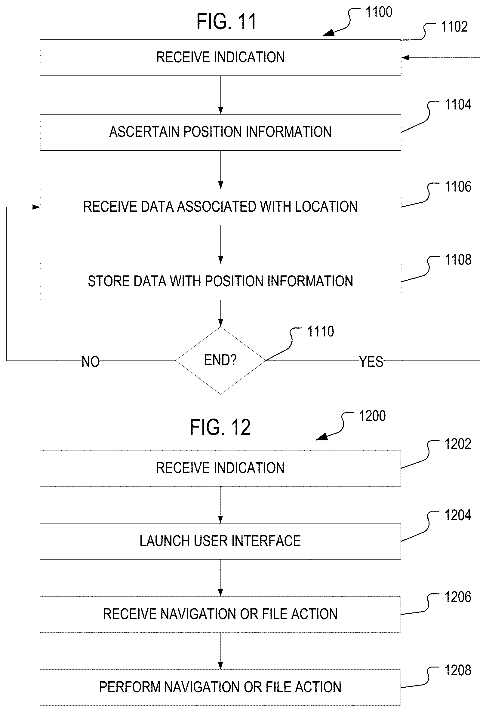
[0073] FIG. 11 is a flow diagram of an example process 1100 for indicating geographic locations of interest and acquiring data associated with the geographic locations of interest. At stage 1102, an indication is received of a geographic location of interest. For example, a location input in the information display area 400 shown in the user interface of FIGS. 4 and 5 is confirmed as a geographic location of interest by a selection of the save object 408.
[0074] At stage 1104, the geographic position information of the geographic location of interest is ascertained. For example, this information can be manually input or obtained from GPS coordinate data. At stage 1106, data associated with location is received. For example, notes, pictures, audio and/or video associated with the geographic location of interest is input to the mobile device 100 by a selection of the camera object 136 or the notes object 146.
[0075] At stage 1108, data is stored with the geographic position information. For example, the notes, pictures, audio and/or video received at stage 1106 are saved with the geographic position information in the mobile device 100. The geographic position information can be automatically appended to the notes, pictures, audio and/or video, or manually input by the user during the save operation.
[0076] At stage 1110, it is determined if more data is to be associated with the geographic location of interest. If so, the process flows to stage 1106. If no more data is to be associated with the geographic location of interest, the process returns to stage 1102.
[0077] FIG. 12 is a flow diagram of an example process 1200 for reviewing and editing data associated with geographic locations of interest. At stage 1202, an indication is received. For example, a user selects the indicator 406 and an option to edit and/or review data associated with the geographic area identified by indicator 406. At stage 1204, a user interface is provided (e.g., launched). For example, in accordance with the type of data to be displayed, one of user interfaces 500 or 600 is launched to view and/or edit pictures, videos, and/or notes associated with the geographic location of interest identified by indicator 406.
[0078] At stage 1206, an indication of an action is received. For example, a user input from one of objects 502, 504, 506 and/or 508 is received by the mobile device 100. At stage 1208, the received action is performed. For example, a next picture is displayed if the next object 502 is selected, or a previous picture is displayed if the back object 504 is selected. A displayed picture is saved if the save object 506 is selected, or deleted if the deleted object 508 is selected by the user.
[0079] FIG. 13 is a flow diagram of an example process 1300 for interactively displaying data associated with geographic locations of interest. At stage 1302, an indication is received. For example, after invoking the maps object 144, the user selects data associated with "My Trip to California." At stage 1304, data is retrieved. For example, the data associated with the saved locations of interest identified by "My Trip to California" is retrieved from the memory 350 in the mobile device 100.
[0080] At stage 1306, a user interface is displayed. For example, the user interface of FIG. 9 is displayed on the mobile device 100. At stage 1308, an indication of location is received. For example, the user selects indicator 406 on the touch sensitive display 102. At stage 1310, data is presented. For example, the interface of FIG. 7 is displayed, from which the user can select to view notes, pictures, audio and/or video. In accordance with the selection made by the user, the user interface 500 or 600 is presented to view the data requested.
[0081] After the data is presented, the flow returns to stage 1306. For example, when the user selects the back object 708, the user interface of FIG. 9 (or FIG. 10) is displayed.
[0082] FIG. 14 is a flow diagram of an example process 1400 for playback of data associated with one or more geographic locations of interest. At stage 1402, an indication is received. For example, a location input in the information display area 400 shown in the user interface of FIGS. 4 and 5 is confirmed as a geographic location of interest, or a selection of object on the touch sensitive display 102 is received.
[0083] At stage 1404, an application is launched. For example, a playback application (e.g., media player) executing on the mobile device 100 or end-user device 280 is launched. At stage 1406, data is retrieved. For example, data associated with the geographic location of interest is retrieved from the memory 350 or from a remote location and communicated over the wide area network and/or wireless network to the mobile device 100 or end-user device 280.
[0084] At stage 1408, a user interface is presented. For example, the user interface associated with the media player is displayed on the mobile device 100 or end-user device 280.
[0085] At stage 1410, the data associated with the geographic location of interest is presented in the user interface. In accordance with a playback mode, the notes, pictures, and/or video associated with the geographic locations of interest are played back in sequence without any user interaction.
[0086] The disclosed embodiments can be implemented in a computing system that includes a back-end component, e.g., as a data server, or that includes a middleware component, e.g., an application server, or that includes a front-end component, e.g., a client computer having a graphical user interface or a Web browser through which a user can interact with an implementation of what is disclosed here, or any combination of one or more such back-end, middleware, or front-end components. The components of the system can be interconnected by any form or medium of digital data communication, e.g., a communication network. Examples of communication networks include a local area network ("LAN") and a wide area network ("WAN"), e.g., the Internet.
[0087] The computing system can include clients and servers. A client and server are generally remote from each other and typically interact through a communication network. The relationship of client and server arises by virtue of computer programs running on the respective computers and having a client-server relationship to each other.
[0088] While this specification contains many specifics, these should not be construed as limitations on the scope of what being claims or of what may be claimed, but rather as descriptions of features specific to particular embodiments. Certain features that are described in this specification in the context of separate embodiments can also be implemented in combination in a single embodiment. Conversely, various features that are described in the context of a single embodiment can also be implemented in multiple embodiments separately or in any suitable sub-combination. Moreover, although features may be described above as acting in certain combinations and even initially claimed as such, one or more features from a claimed combination can in some cases be excised from the combination, and the claimed combination may be directed to a sub-combination or variation of a sub-combination.
[0089] Similarly, while operations are depicted in the drawings in a particular order, this should not be understand as requiring that such operations be performed in the particular order shown or in sequential order, or that all illustrated operations be performed, to achieve desirable results. In certain circumstances, multitasking and parallel processing may be advantageous. Moreover, the separation of various system components in the embodiments described above should not be understood as requiring such separation in all embodiments, and it should be understood that the described program components and systems can generally be integrated together in a single software product or packaged into multiple software products.
[0090] Embodiments described herein provided techniques to enable location information to be used to build a database of locations having associated audio, video, image or text data. One embodiment provides for a method including presenting a map of a geographic region on a touch-sensitive display; receiving touch input selecting a geographic location; determining geographic positioning information of the geographic location; receiving data in response to an input received by a touch-sensitive display; associating the data with the geographic positioning information of the geographic location to produce geographically tagged data; and storing the geographically-tagged data.
[0091] A further embodiment provides for a method including presenting indications of a predetermined group of geographic locations on a touch-sensitive display; receiving a selection of a geographic location from the group of geographic locations displayed on the touch-sensitive display; and presenting geographically tagged data associated with the geographic location in a user interface on the touch-sensitive display.
[0092] In one embodiment a user interface includes a touch-sensitive display area for displaying indications of a predetermined group of geographic locations associated by an attribute, wherein each indication represents geographically coded data associated with a geographic position, and wherein a name of the attribute is displayed in the user interface. In one embodiment, a geographic location of interest can be determined based on an image captured by a camera of a mobile device. A geographic location can be determined based on the captured image. Additional data related to the geographic location can be displayed based on the geographic location determined based on the captured image. The geographic location can be determined based on geographically coded data associated with or included within the image.
[0093] Various modifications may be made to the disclosed implementations and still be within the scope of the following claims.
* * * * *
D00000
D00001
D00002
D00003
D00004
D00005
D00006
D00007
XML
uspto.report is an independent third-party trademark research tool that is not affiliated, endorsed, or sponsored by the United States Patent and Trademark Office (USPTO) or any other governmental organization. The information provided by uspto.report is based on publicly available data at the time of writing and is intended for informational purposes only.
While we strive to provide accurate and up-to-date information, we do not guarantee the accuracy, completeness, reliability, or suitability of the information displayed on this site. The use of this site is at your own risk. Any reliance you place on such information is therefore strictly at your own risk.
All official trademark data, including owner information, should be verified by visiting the official USPTO website at www.uspto.gov. This site is not intended to replace professional legal advice and should not be used as a substitute for consulting with a legal professional who is knowledgeable about trademark law.