Method For Producing An Autonomous Navigation Map For A Vehicle
ROBERT; Emmanuel ; et al.
U.S. patent application number 16/347151 was filed with the patent office on 2020-02-20 for method for producing an autonomous navigation map for a vehicle. The applicant listed for this patent is SAFRAN ELECTRONICS & DEFENSE, VALEO SCHALTER UND SENSOREN GMBH. Invention is credited to Philippe GOUGEON, Emmanuel ROBERT, Jacques YELLOZ.
| Application Number | 20200057451 16/347151 |
| Document ID | / |
| Family ID | 59030990 |
| Filed Date | 2020-02-20 |


| United States Patent Application | 20200057451 |
| Kind Code | A1 |
| ROBERT; Emmanuel ; et al. | February 20, 2020 |
METHOD FOR PRODUCING AN AUTONOMOUS NAVIGATION MAP FOR A VEHICLE
Abstract
The method of preparing a navigation autonomy map for a vehicle covering a zone including path segments, comprising the following steps: identifying the path segments for which the map needs to be prepared; for each path segment, calculating a primary autonomy index in accordance with at least two distinct functions; and calculating for each path segment a final autonomy index by taking a weighted average of the primary autonomy indices. An autonomy map, an application of the autonomy map, and a vehicle using such an autonomy map.
| Inventors: | ROBERT; Emmanuel; (BOULOGNE BILLANCOURT, FR) ; YELLOZ; Jacques; (BOULOGNE BILLANCOURT, FR) ; GOUGEON; Philippe; (CRETEIL, FR) | ||||||||||
| Applicant: |
|
||||||||||
|---|---|---|---|---|---|---|---|---|---|---|---|
| Family ID: | 59030990 | ||||||||||
| Appl. No.: | 16/347151 | ||||||||||
| Filed: | November 2, 2017 | ||||||||||
| PCT Filed: | November 2, 2017 | ||||||||||
| PCT NO: | PCT/EP2017/078101 | ||||||||||
| 371 Date: | May 2, 2019 |
| Current U.S. Class: | 1/1 |
| Current CPC Class: | G01C 21/32 20130101; G05D 1/0274 20130101; G05D 2201/0213 20130101; G05D 1/0088 20130101 |
| International Class: | G05D 1/02 20060101 G05D001/02; G01C 21/32 20060101 G01C021/32; G05D 1/00 20060101 G05D001/00 |
Foreign Application Data
| Date | Code | Application Number |
|---|---|---|
| Nov 2, 2016 | FR | 1660599 |
Claims
1. A method of preparing a navigation autonomy map for a vehicle covering a zone including path segments, the method comprising the following steps: identifying the path segments for which the map needs to be prepared; for each path segment, calculating primary autonomy reliability indices in accordance with at least two distinct autonomy functions; and calculating for each path segment a final autonomy reliability index on the basis of the primary autonomy reliability indices.
2. The method according to claim 1, wherein the final autonomy reliability index is calculated by taking a weighted average of the primary autonomy reliability indices.
3. The method according to claim 2, further comprising the following steps: performing a plurality of calculations for each final index with distinct weighting coefficients; comparing the resulting final indices; and preparing the navigation autonomy map by retaining the weighting for which the lowest final index is the highest of the lowest final indices of the various weightings.
4. The method according to claim 2, further comprising the following steps: performing a plurality of calculations for each final index with distinct weighting coefficients; comparing the resulting final indices; and preparing the navigation autonomy map by retaining the highest final index for each path segment.
5. The method according to claim 1, further comprising the steps of identifying path segments for which the final autonomy reliability indices are less than a predetermined threshold, and of performing a smoothing operation applied to the immediately adjacent path segments.
6. The method according to claim 1, further comprising a prior step of analyzing the configuration of the path segments and of installing equipment adapted to improve the primary autonomy reliability indices.
7. A navigation autonomy map for a vehicle covering a zone comprising path segments, the map comprising for each path segment it includes a final autonomy reliability index obtained by taking a weighted mean of primary autonomy reliability indices in accordance with at least two distinct autonomy functions.
8. The application of an autonomy map according to claim 7 for determining a path, wherein autonomy parameters are added to geographical parameters for determining the path.
9. An autonomous vehicle including an automatic driver unit and a navigation unit; the automatic driver unit being connected to vehicle control members and to sensors for detecting the behavior of the vehicle and the surroundings of the vehicle, and incorporating calculation means enabling the control members to be driven on the information supplied by the sensors so that the vehicle remains on a determined path in compliance with traffic regulations; the navigation unit comprising a module for planning itineraries on the basis of map data comprising an autonomy map according to claim 7, the autonomy map being used both by the navigation unit to determine an itinerary as a function of the final indices of the segments traveled, and also by the driver unit to determine which sensors should be given precedence on the basis of the segment traveled.
Description
[0001] The present invention provides a method of preparing a navigation autonomy map for a vehicle, a resulting autonomy map, and an application of that map to determining a path.
BACKGROUND OF THE INVENTION
[0002] Nowadays, conventional vehicles are very widely provided with navigation systems including map data and capable of performing an itinerary planning algorithm on the basis of that data. Such systems include the global positioning system (GPS), but they are nevertheless not designed, on their own, to allow a vehicle to operate without a driver.
[0003] It is also known that a large amount of work is being undertaken for the purpose of enabling vehicles traveling on the road network to navigate autonomously, i.e. without intervention from a driver.
[0004] The appearance of autonomy functions in vehicles raises the problem of a risk of those functions failing and of the resulting consequences. Such functions provide solutions to navigating and/or driving the vehicle only if all of the external information that is needed is present and properly processed by the onboard system. Otherwise, they either fail and the driver needs to take over, or else they act erroneously, and takeover by the driver is even more difficult.
[0005] Various means exist at present for providing a navigation autonomy function in a vehicle, or at least for contributing to such an autonomy function. The main techniques that exist at present are known as: GPS (mentioned above); light detection and ranging (LIDAR) or laser detection and ranging (LADAR); inertial navigation system (INS); techniques making use of detecting markings on the ground; techniques making use of dedicated signals being transmitted by transmitters arranged in road infrastructure equipment, in particular traffic lights, . . . .
[0006] None of those techniques is satisfactory, on its own, for covering an entire road network.
OBJECT OF THE INVENTION
[0007] An object of the invention is to propose a method of preparing a navigation autonomy map for a vehicle, which method is reliable over all of the segments of a path in a given zone.
SUMMARY OF THE INVENTION
[0008] In order to achieve this object, the invention provides a method of preparing a navigation autonomy map for a vehicle covering a zone including path segments, the method comprising the following steps: identifying the path segments for which the map needs to be prepared; for each path segment, calculating primary autonomy indices in accordance with at least two distinct autonomy functions; and calculating for each path segment a final autonomy index on the basis of the primary autonomy indices.
[0009] Thus, by selecting additional autonomy functions adapted to the configuration of the zone under consideration, a final autonomy index is obtained for each segment of the path, which final index presents reliability that is improved compared with any one existing technique. As a result, the autonomy map combines particular map data such as the autonomy indices that serve to increase the safety of autonomous vehicles, e.g. by enabling them to plan paths for which the segments are associated with autonomy indices that are the most favorable for autonomy.
[0010] In an advantageous version of the invention, the final autonomy index is calculated by taking a weighted average of the primary autonomy indices and the method includes the following steps: performing a plurality of calculations for each final index with distinct weighting coefficients; comparing the resulting final autonomy indices; and preparing the navigation autonomy map by retaining the weighting for which the lowest final index is the highest of the lowest final indices of the various weightings.
[0011] This further improves the accuracy of the resulting navigation autonomy map.
[0012] In another advantageous version of the invention, the method includes the following steps: performing a plurality of calculations for each final index with distinct weighting coefficients; comparing the resulting final autonomy indices; and preparing the navigation autonomy map by retaining the highest final autonomy index for each path segment.
[0013] In another aspect of the invention, the method includes the steps of: identifying path segments for which the final autonomy indices are less than a predetermined threshold; and of smoothing the immediately adjacent path segments. Preferably, the method includes a prior step of analyzing the configuration of the path segments and of installing equipment adapted to improve the primary autonomy indices.
[0014] The invention also provides: a navigation autonomy map for a vehicle covering a zone comprising path segments, wherein, for each path segment, the map includes a final autonomy index obtained by taking a weighted mean of primary autonomy indices in accordance with at least two distinct autonomy functions; and an application of this autonomy map to determining a resulting path by adding autonomy parameters to the various parameters (travel time, toll booths, . . . ) that are presently in use for determining a path.
BRIEF DESCRIPTION OF THE DRAWINGS
[0015] Other characteristics and advantages of the invention appear further on reading the following description of a preferred, non-limiting implementation of the invention given with reference to the accompanying figures, in which:
[0016] FIG. 1 is a block diagram of the method of the invention:
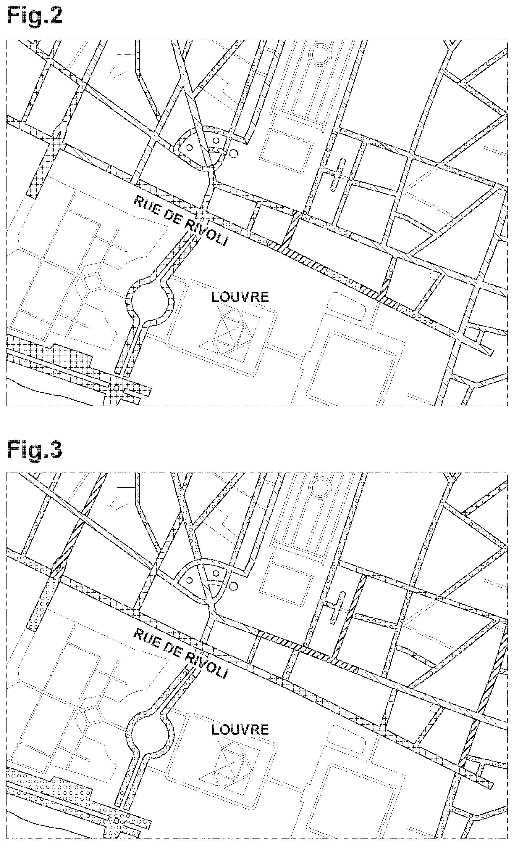
[0017] FIG. 2 is a map including primary indices calculated for a first autonomy function;
[0018] FIG. 3 is a map including primary indices calculated for a second autonomy function;
[0019] FIG. 4 is a map including primary indices calculated for a third autonomy function; and
[0020] FIG. 5 is a map including final indices, calculated from the primary indices of the above figures.
DETAILED DESCRIPTION OF THE INVENTION
[0021] With reference to the figures, the method shown comprises a first step 1 of analyzing the configuration of path segments, followed by a second step 2 of selecting autonomy functions. For example, in a city of close-packed structure, comprising buildings that are very close together, and provided with a large amount of marking on the ground and with dedicated transmitters located in urban equipment, the corresponding recognition parameters should be selected, whereas on an open road the GPS autonomy function should be selected.
[0022] Thereafter, in a third step 3, primary autonomy indices are calculated followed by a fourth step 4 of calculating final indices by taking a weighted mean of the primary indices. The weighting coefficients correspond to the relative importance of each primary index for the autonomy of the vehicle (e.g. in a given segment, the fact of having accurate ground marking and a high definition map may be more important than the fact of having a visual reference point in line of sight). The weighting coefficients may be determined a priori, or they may be updated periodically or in real time depending on traffic conditions (a weather event such as fog, the presence of an accident or of roadworks). The weighted mean may be a mean that is weighted under constraints (under such circumstances, it is considered that when the primary index is less than a value X, then the coefficient that is associated therewith is equal to 0, whereas when the primary index is greater than the value X, the coefficient is equal to 1). For example, assuming that a law bans autonomous traffic when ground marking is obliterated, then using a weighted mean under constraints makes it possible for the criterion relating to ground marking to be made preponderant over the others when ground marking is absent.
[0023] If the resulting final indices do not appear to be sufficiently reliable, then the final indices are preferably calculated once more using a different weighting, followed by a comparison step 5 and a selection step 6, possibly followed by a smoothing step 7, e.g. by using an inertial navigation system.
[0024] FIG. 2 shows the results of calculating primary indices for a part of Paris, by using the GPS autonomy function. The value for the primary index is illustrated by four decreasing values using the following signs: + sign; light shading; bold shading; small circles.
[0025] FIG. 3 shows the result of calculation using the LIDAR autonomy function, with the same signs for representing the indices that are obtained.
[0026] FIG. 4 shows the result of calculation using the ground marking autonomy function, still with the same signs.
[0027] FIG. 5 shows the result of calculating a weighted mean on the basis of the above three. It can be seen that the quality of the GPS index over a portion of rue de Rivoli is degraded in part by the other autonomy functions. Nevertheless, a correction can be carried out using the INS autonomy function. It should be observed in this context that the quality of the index depends on the quality of the components used. In particular, a good quality INS can make it possible to raise all of the segments of the path to the higher value. The quality of the components associated with the method of the invention thus makes it possible to distinguish between vehicles that are genuinely equipped for autonomous navigation, and vehicles that are autonomous only under determined circumstances.
[0028] The autonomous vehicle suitable for performing the method of the invention has an automatic driver unit and a navigation unit. The automatic driver unit is connected to the control members of the vehicle such as the steering system, the engine, the braking system, and also to sensors for detecting the behavior of the vehicle and of the surroundings of the vehicle, and it incorporates calculation means enabling the control members to be driven on the basis of information provided by the sensors so that the vehicle remains on a determined path while complying with traffic regulations. By way of example, the navigation unit has a GPS module and a module for planning itineraries on the basis of map data comprising the autonomy map. The autonomy map is used both by the navigation unit for determining an itinerary depending on the indices for the segments traveled, and by the driver unit that determines, depending on the segments being traveled, which sensors should be given precedence (for example, in a zone where GPS signals are received with poor quality, GPS information should be ignored for driving the vehicle in order to limit any risk that taking such information into account would degrade the accuracy of autonomous driving).
[0029] The autonomy maps may advantageously be used by an organization that manages the road network in order to identify segments of the network that need to be improved for autonomous vehicle traffic (by reworking ground signaling, by installing radiofrequency identity (RFID) beacons for delivering information to autonomous vehicles, . . . ).
[0030] The autonomy maps may advantageously be used by motor manufacturers to enable them to determine the portions of a network on which their vehicles can operate in autonomous manner and to enable them to improve their vehicles by assisting in identifying which sensors autonomous vehicles need to have in order to enable them to drive autonomously on a larger fraction of the network.
[0031] Naturally, the invention is not limited to the implementation described, and variant implementations may be devised without going beyond the ambit of the invention as defined by the claims.
[0032] In particular, it can be understood that the autonomy of a vehicle depends on the sensors that are present on the vehicle. Consequently, an autonomy map should be prepared for each model, or indeed each version, of a vehicle. It is also possible to envisage providing organizations that manage the road network on a local scale or a national scale with "global" autonomy maps corresponding to several types or models of autonomous vehicle. For example, a "minimum" autonomy map should be prepared based on the minimum equipment of autonomous vehicles, together with a "maximum" autonomy map based on the maximum equipment of autonomous vehicles.
[0033] Instead of using an average, it is possible to calculate the degree of autonomy by using the minimum of all of the criteria for each segment.
* * * * *
D00000
D00001
D00002
D00003
XML
uspto.report is an independent third-party trademark research tool that is not affiliated, endorsed, or sponsored by the United States Patent and Trademark Office (USPTO) or any other governmental organization. The information provided by uspto.report is based on publicly available data at the time of writing and is intended for informational purposes only.
While we strive to provide accurate and up-to-date information, we do not guarantee the accuracy, completeness, reliability, or suitability of the information displayed on this site. The use of this site is at your own risk. Any reliance you place on such information is therefore strictly at your own risk.
All official trademark data, including owner information, should be verified by visiting the official USPTO website at www.uspto.gov. This site is not intended to replace professional legal advice and should not be used as a substitute for consulting with a legal professional who is knowledgeable about trademark law.