Method And Apparatus For Identifying And Presenting Location And Location-related Information
Lau; Chung ; et al.
U.S. patent application number 16/354122 was filed with the patent office on 2019-07-11 for method and apparatus for identifying and presenting location and location-related information. The applicant listed for this patent is IpVenture, Inc.. Invention is credited to Chung Lau, C. Douglass Thomas, Peter P. Tong.
| Application Number | 20190215643 16/354122 |
| Document ID | / |
| Family ID | 38015814 |
| Filed Date | 2019-07-11 |


View All Diagrams
| United States Patent Application | 20190215643 |
| Kind Code | A1 |
| Lau; Chung ; et al. | July 11, 2019 |
METHOD AND APPARATUS FOR IDENTIFYING AND PRESENTING LOCATION AND LOCATION-RELATED INFORMATION
Abstract
Method and apparatus to analyze and present location information in an easy-to-digest manner are disclosed. In one embodiment, each piece of location information can include a piece of location-designating information and a piece of location-related information. Location-designating information is primarily for identifying location. Location-related information is information related to location-designating information. The location-designating information and the location-related information can be supplied by a mobile device. With the help of location-related information, each piece of location-designating information can be more accurately transformed into a label to help identify a location. The amount of location information can be reduced. All of the location-designating information pertaining to a given area can be consolidated into one piece of location-designating information related to the label. Consolidation of some of the information may not occur if a piece of location-related information changes by more than a preset value. To better present location information in an easy-to-digest manner, location information can be compared to standards. Presentation can be on a display with respect to a reference location.
| Inventors: | Lau; Chung; (Sunnyvale, CA) ; Tong; Peter P.; (Mountain View, CA) ; Thomas; C. Douglass; (Saratoga, CA) | ||||||||||
| Applicant: |
|
||||||||||
|---|---|---|---|---|---|---|---|---|---|---|---|
| Family ID: | 38015814 | ||||||||||
| Appl. No.: | 16/354122 | ||||||||||
| Filed: | March 14, 2019 |
Related U.S. Patent Documents
| Application Number | Filing Date | Patent Number | ||
|---|---|---|---|---|
| 15634019 | Jun 27, 2017 | |||
| 16354122 | ||||
| Current U.S. Class: | 1/1 |
| Current CPC Class: | H04W 4/029 20180201; H04W 4/02 20130101; H04W 64/00 20130101; H04W 4/023 20130101; G06F 3/04817 20130101; G06Q 10/10 20130101; H04W 4/021 20130101; G01C 21/00 20130101; H04W 4/025 20130101; G01C 21/32 20130101; G06F 3/0482 20130101; H04L 67/02 20130101; G01C 21/005 20130101 |
| International Class: | H04W 4/02 20060101 H04W004/02; H04L 29/08 20060101 H04L029/08; G06F 3/0481 20060101 G06F003/0481; H04W 4/021 20060101 H04W004/021; H04W 64/00 20060101 H04W064/00; G01C 21/32 20060101 G01C021/32; G01C 21/00 20060101 G01C021/00; G06Q 10/10 20060101 G06Q010/10 |
Claims
1. An article to facilitate electronically presenting data based on at least image data from a mobile electronic device, which includes at least a sensor that could sense signals related to locations of the mobile electronic device, the article comprising: a non-transitory computer readable storage medium comprising a plurality of instructions, when executed by at least a computing device, result in the at least a computing device: accessing the image data, the image data being associated with a first location, and the first location being associated with a first time, wherein the first location depends on at least data from a first measurement, and wherein the first measurement is from at least the sensor in the mobile electronic device sensing signals related to at least the first location; generating a plurality of choices associated with at least the first location; facilitating presenting the plurality of choices to a user of the mobile electronic device; receiving a selection via the mobile electronic device of one of the choices, the selection being provided by the user of the mobile electronic device; facilitating presenting on a display at least a part of the image data associated with the first location, together with at least a part of a representation of the selection provided by the user; and facilitating presenting on the display at least a part of a representation of the first time, with the presentation linked to at least a part of the image data associated with the first location of the mobile electronic device.
Description
CROSS REFERENCE TO RELATED APPLICATIONS
[0001] This application is a continuation of U.S. patent application Ser. No. 15/634,019, filed Jun. 27, 2017, and entitled "METHOD AND APPARATUS FOR IDENTIFYING AND PRESENTING LOCATION AND LOCATION-RELATED INFORMATION," which is hereby incorporated herein by reference, and which, in turn, is a continuation of U.S. patent application Ser. No. 14/874,782, filed Oct. 5, 2015, now U.S. Pat. No. 9,723,442, and entitled "METHOD AND APPARATUS FOR IDENTIFYING AND PRESENTING LOCATION AND LOCATION-RELATED INFORMATION," which is hereby incorporated herein by reference, and which, in turn, is a continuation of U.S. patent application Ser. No. 14/519,503, filed Oct. 21, 2014, now U.S. Pat. No. 9,219,988, and entitled "METHOD AND APPARATUS FOR LOCATION IDENTIFICATION AND PRESENTATION," which is hereby incorporated herein by reference, which, in turn, is a continuation of U.S. patent application Ser. No. 13/933,770, filed Jul. 2, 2013, now U.S. Pat. No. 8,886,220, and entitled "METHOD AND APPARATUS FOR LOCATION IDENTIFICATION," which is hereby incorporated herein by reference, which, in turn, is a continuation of U.S. patent application Ser. No. 11/705,339, filed Feb. 10, 2007, now U.S. Pat. No. 8,611,920, and entitled "METHOD AND APPARATUS FOR LOCATION IDENTIFICATION," which is hereby incorporated herein by reference, which, in turn, is a continuation of U.S. patent application Ser. No. 10/397,472, filed Mar. 26, 2003, now U.S. Pat. No. 7,218,938, and entitled "METHOD AND APPARATUS TO ANALYZE AND PRESENT LOCATION INFORMATION," which is hereby incorporated herein by reference. U.S. patent application Ser. No. 09/797,517, filed Feb. 28, 2001, now U.S. Pat. No. 7,366,522, and entitled "METHOD AND SYSTEM FOR LOCATION TRACKING," is hereby incorporated herein by reference.
[0002] The prior application Ser. No. 10/397,472 also claims benefit of: (i) U.S. Provisional Patent Application No. 60/444,198, filed Jan. 30, 2003, and entitled "SYSTEM, METHOD AND APPARATUS FOR ACQUIRING, PRESENTING, MONITORING, DELIVERING, MANAGING AND USING STATUS INFORMATION," which is hereby incorporated herein by reference; (ii) U.S. Provisional Patent Application No. 60/418,491, filed Oct. 15, 2002, and entitled "SYSTEM, METHOD AND APPARATUS FOR ACQUIRING, PRESENTING, MONITORING, DELIVERING, MANAGING AND USING STATUS INFORMATION," which is hereby incorporated herein by reference; (iii) U.S. Provisional Patent Application No. 60/404,645, filed Aug. 19, 2002, and entitled "SYSTEM, METHOD AND APPARATUS FOR ACQUIRING, PRESENTING, MONITORING, DELIVERING, MANAGING AND USING POSITION AND OTHER INFORMATION," which is hereby incorporated herein by reference; and (iv) U.S. Provisional Patent Application No. 60/375,998, filed Apr. 24, 2002, and entitled "SYSTEM, METHOD AND APPARATUS FOR ACQUIRING, PRESENTING, MANAGING AND USING POSITION INFORMATION," which is hereby incorporated herein by reference.
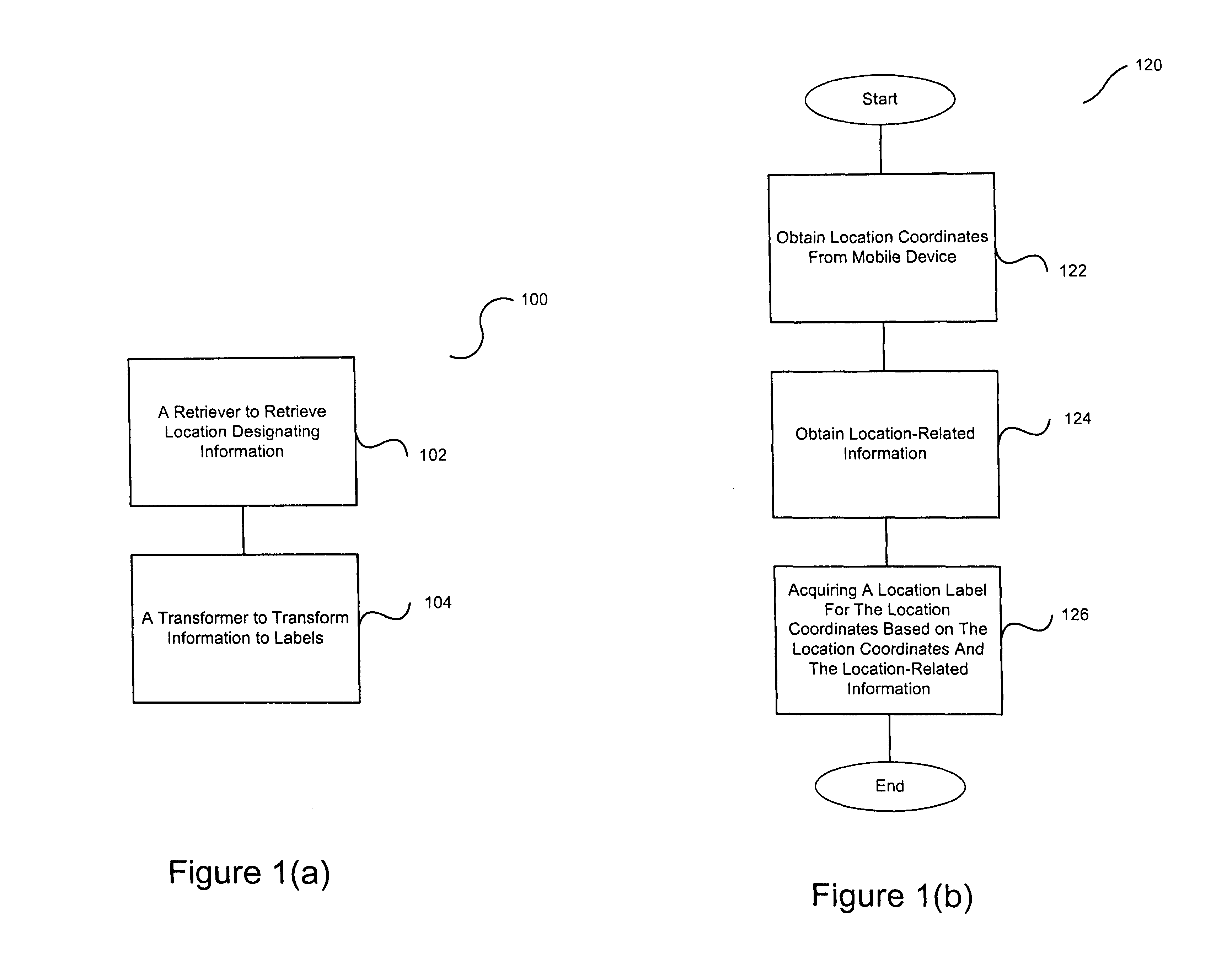
[0003] This application is also related to: (i) U.S. patent application Ser. No. 10/397,473, filed Mar. 26, 2003, now U.S. Pat. No. 6,975,941, and entitled "METHOD AND APPARATUS FOR INTELLIGENT ACQUISITION OF POSITION INFORMATION;" (ii) U.S. patent application Ser. No. 10/397,637, filed Mar. 26, 2003, now U.S. Pat. No. 7,212,829, and entitled "METHOD AND SYSTEM FOR PROVIDING SHIPMENT TRACKING AND NOTIFICATIONS;" (iii) U.S. patent application Ser. No. 10/397,641, filed Mar. 26, 2003, now U.S. Pat. No. 7,905,832, and entitled "METHOD AND SYSTEM FOR PERSONALIZED MEDICAL MONITORING AND NOTIFICATIONS THEREFOR;" (iv) U.S. patent application Ser. No. 10/397,640, filed Mar. 26, 2003, now U.S. Pat. No. 7,321,774, and entitled "INEXPENSIVE POSITION SENSING DEVICE;" (v) U.S. patent application Ser. No. 10/397,474, filed Mar. 26, 2003, now U.S. Pat. No. 7,403,972, and entitled "METHOD AND SYSTEM FOR ENHANCED MESSAGING;" (vi) U.S. patent application Ser. No. 10/397,512, filed Mar. 26, 2003, and entitled "APPLICATIONS OF STATUS INFORMATION FOR INVENTORY MANAGEMENT."
BACKGROUND OF THE INVENTION
[0004] GPS (Global Positioning System) has been used extensively for navigation, positioning, and other research applications. It includes a group of satellites transmitting very precise signals. The nominal GPS Operational Constellation consists of 24 satellites that orbit the earth with 12-hour periods. These space vehicles (SV's) send radio signals that consist of time-tagged data bits marking the time of transmission, and information on the locations of the SV's, at the time they are transmitted. GPS receivers convert the received SV signals into the receivers' position. Four satellites are required to compute the four dimensions of X, Y, Z (position) and time. GPS receivers at precisely known reference locations can provide corrections and relative positioning data for receivers at other locations. Another use of GPS is to provide precise time and frequency standards through the use of precise clocks on-board the SV's.
[0005] For about two decades, GPS receivers have been used primarily in the outdoor environment. It is more challenging to use them indoors. The signal strengths from the SV's can be much reduced, such as by two orders of magnitude. A number of companies have been developing indoor GPS receivers. They are enticed by the US Federal Communications Commission's E911 telecommunication initiatives, which require wireless phone providers to locate any phone making a 911 emergency call.
[0006] The E911 initiative will greatly increase the proliferation of GPS devices. Telematics--the field of mobile services delivered wirelessly to in-vehicle devices--will further help GPS penetrate into different sectors of the society. One of the most visible manifestations of telematics is GPS-based navigation systems. They provide turn-by-turn directions and other information wirelessly to vehicle operators.
[0007] The amount and availability of GPS information will dramatically increase in the coming years. One challenge this will present is how to effectively use such information. There are needs for techniques to efficiently and intelligently analyze, process and present GPS information.
SUMMARY OF THE INVENTION
[0008] In general terms, the present invention pertains to the analysis of location information and/or the presentation of such information in an easy-to-digest manner.
[0009] Each piece of location information can include a piece of location-designating information and a piece of location-related information. Location-designating information is primarily for identifying location. In one embodiment, the location-designating information is longitudinal and latitudinal coordinates. Location-related information is information related to location-designating information. The location-designating information and the location-related information can be supplied by a mobile device. Multiple pieces of location-designating information can be retrieved and processed.
[0010] In one embodiment, each piece of location-designating information can be transformed into a label to help identify a location. To better identify locations, the process of transforming location-designating information into labels can use location-related information. For example, the mobile device is very close to the boundary of a theatre and a bookstore, and is about 40 feet from the ground level. One piece of location-related information is information on the environment. It indicates that the theatre has only one floor, while the bookstore has three floors. Since only the bookstore has more than one level and the mobile device is about 40 feet from the ground level, the mobile device is in the bookstore, not the theatre.
[0011] In another embodiment, the amount of location information can be reduced. An entire area can, for example, be represented by a single label. For analysis, all of the location-designating information pertaining to a given area can be compressed (or consolidated) into one piece of location-designating information related to the label. This compression (or consolation) process can be impacted or assisted by location-related information. For example, if a piece of location-related information changes by more than a pre-set value, the corresponding piece of location information will be retained.
[0012] To better present location information in an easy-to-digest manner, location information can be compared to standards. The standards can be related to time.
[0013] Presentation can be visually on a display with respect to a reference location. For example, the amount of detail displayed between the location of the mobile device and the reference location can dynamically change. This change can depend on the distance between the location of the mobile device and the reference location. Such an implementation is helpful particularly in situations when the size of the display is fixed.
[0014] The invention can be implemented in numerous ways, including as a method, system, device, or computer readable medium. Different embodiments of the invention will be discussed in subsequent sections.
[0015] Other aspects and advantages of the present invention will become apparent from the following detailed description, which, when taken in conjunction with the accompanying drawings, illustrates by way of examples the principles of the invention.
BRIEF DESCRIPTION OF THE DRAWINGS
[0016] FIG. 1(a) shows one embodiment of the present invention.
[0017] FIG. 1(b) is a flow diagram of label processing according to one embodiment of the invention.
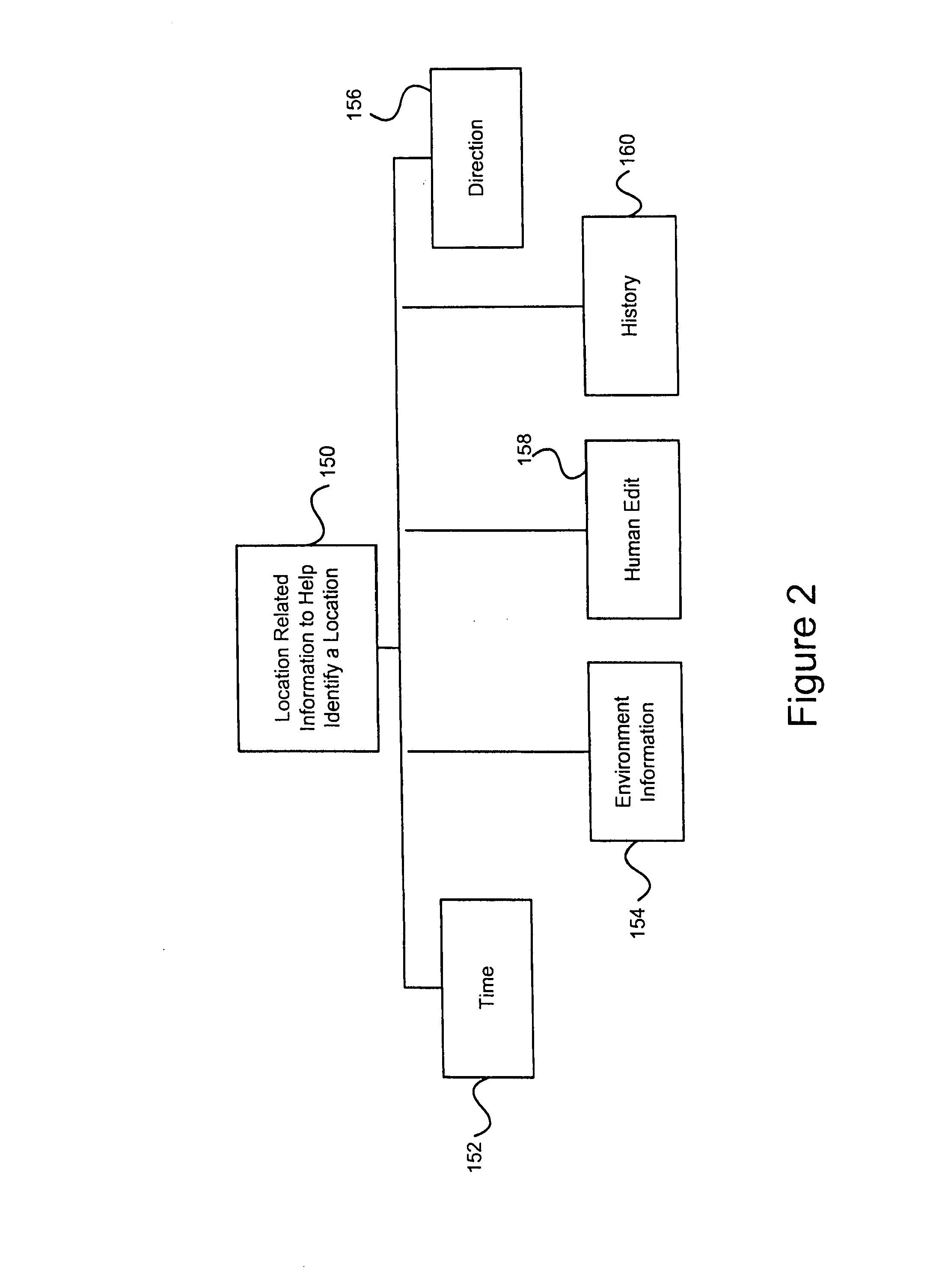
[0018] FIG. 2 shows examples of location-related information to help identify a location in the present invention.
[0019] FIG. 3(a) shows one embodiment of compressing location information in the present invention.
[0020] FIG. 3(b) illustrates an exemplary path of movement of a location-designating device over a period of time.
[0021] FIG. 3(c) is a flow diagram of consolidation processing according to one embodiment of the invention.
[0022] FIG. 4 shows embodiments regarding retaining location information in the present information.
[0023] FIG. 5 shows embodiments of attaching location information to other information in the present invention.
[0024] FIG. 6 shows examples of standards compared to location information in the present information.
[0025] FIG. 7 shows embodiments related to the presentation of location information in the present invention.
[0026] FIG. 8 shows one embodiment of using location information to calibrate a compass in the present invention.
[0027] Same numerals in FIGS. 1-8 are assigned to similar elements in all the figures. Embodiments of the invention are discussed below with reference to FIGS. 1-8. However, those skilled in the art will readily appreciate that the detailed description given herein with respect to these figures is for explanatory purposes as the invention extends beyond these limited embodiments.
DETAILED DESCRIPTION OF THE INVENTION
[0028] The present invention pertains to the analysis of location information and/or the presentation of such information in an easy-to-digest manner. In one embodiment, there are two types of location information. One type is location-designating information, and the other is location-related information. Location-designating information is primarily for identifying locations. The location-designating information can be longitudinal and latitudinal co-ordinates, or raw measurements (or pseudo-ranges) from GPS satellites. Location-related information is additional information that is related to a location. As will be explained in detail below, the location-designating information and the location-related information can be used in analyzing and presenting location information.
[0029] There can be a number of ways to generate location-related information. Some of the information can be automatically captured by additional sensors. Other can be entered by a person. For example, a user with a mobile device is in a bookstore. The mobile device is location-aware (e.g., GPS enabled) and can capture location-designating information. One type of location-aware mobile device is a mobile device that includes a GPS device (or GPS receiver). The user can add comments about the bookstore, or enter personal information and digitized pictures into his mobile device. The URL of the bookstore can be included. The user can be next to a house with a Wi-Fi network that allows the mobile device to get online. These can all be information related to the location, and can be automatically provided, or entered by the user. Such location-related information can be coupled to location-designating information, such as for identifying the location of the bookstore.
[0030] The company or organization at the location can broadcast certain information for attachment. For example, the bookstore can broadcast the URL of its website, or of special offers using the Bluetooth standards. Assume that the mobile device has Bluetooth technologies, and is Bluetooth enabled. With authorized reception of data, the mobile device can capture the broadcast signal and attach the information as a piece of location-related information.
[0031] Other sensors can be coupled to the mobile device to capture location-related information. For example, there can be a temperature sensor, a digital compass, a humidity sensor, a pressure sensor, a wind-speed sensor, an acceleration sensor or an accelerometer, a chemical sensor detecting chemical substance, a mechanical stress sensor, and/or other sensors to provide location-related information. The sensor data can be electronically coupled to corresponding location-designating information as location-related information.
[0032] Some of these sensors can be micro-electro-mechanical systems or micromachines. These sensors can be integrated with driving, controlling and signal processing electronics, and the integration can be monolithic.
[0033] The present invention can be implemented in a computing system. The computing system can be a standalone computing apparatus, a server computer, a client computer, a server computer with one or more client computers, or a computer in a peer-to-peer network. A client computer can be a thin-client. A client computer communicates to the server computer through a communication link or computer network. In one embodiment, a server computer, which can be software and/or hardware, is capable of responding to a communication initiated by a client computer with respect to an application. Similarly, a client computer, which can be software and/or hardware, is capable of initiating communication with a server computer with respect to an application. The computing system can also be a handheld computer, a personal digital assistant or a cellular phone.
[0034] The computing system can include a bus connecting a number of components, such as a processing unit, a main memory, an I/O controller, a peripheral controller, a graphics adapter, a circuit board and a network interface adapter. The I/O controller can be connected to components, such as a hard disk drive or a floppy disk drive. The peripheral controller can be connected to one or more peripheral components, such as a keyboard or a pointing device. The graphics adapter can be connected to a monitor. The circuit board can be coupled to audio signals; and the network interface adapter can be connected to the network, which can be the Internet, an intranet, or other forms of networks. The processing unit can be an application specific chip. The computing system can include more than one processor, and can process information through parallel processing.
[0035] The present invention can also be implemented as a computer readable medium including at least computer program code for analyzing and/or presenting location information according to different embodiments described.
[0036] FIG. 1(a) shows a location resolution system 100 according to one embodiment of the present invention. The location resolution system 100 includes a retriever 102 to retrieve location information, and a transformer 104 to transform location-designating information into labels. Typically, location-designating information includes a set of numerical values. They can be raw measurements from GPS devices, or longitudinal and latitudinal coordinates, or other numerical representation of locations. It is not easy for a person to know where a location is just by looking at these numerical values.
[0037] In one embodiment of the present invention, labels are representations of locations that are easier to understand than the numerical representations. For example, instead of the set of longitudinal and latitudinal coordinates--W 122.degree. 26' 52.9'' and N 37.degree. 48' 11.2''--its corresponding label can be the Exploratorium, the name of the place (e.g., business, home or other point of interest) with that set of coordinates. A label can be the physical address of the place. In the case of the Exploratorium, it is 3601 Lyon Street, San Francisco, Calif. 94123. Labels can help people better identify a place than a set of numbers.
[0038] In transforming location-designating information into labels, the transformer can access a location database. In one embodiment, a previously-created database maps location-designating information, such as longitudinal and latitudinal co-ordinates, to their corresponding labels. The location database can be in the mobile device or in a remote server wirelessly coupled to the mobile device. Access to the location database can be restricted through password protection or other techniques.
[0039] The system identifies the labels corresponding to location-designating information, and retrieves such information from the database. The system can be in the mobile device or it can be in a remote server. Labels can then replace the location-designating information, and can couple to the corresponding location-related information. For example, the location-related information can be stored along with the labels in the mobile device, such as a personal-digital assistant. In another example, the location-related information is stored along with the labels in a remote computer.
[0040] In one embodiment, the location information can then be queried by a query processor. The query processor can be used by a person to query the information. As an example, one can search for the label, "Exploratorium". The following information can be retrieved in a table format:
TABLE-US-00001 Location Exploratorium Address 3601 Lyon Street, San Francisco, CA 94123 GPS co-ordinates W 122.degree. 26' 52.9'' N 37.degree. 48' 11.2'' Web site www.exploratorium.edu Miscellaneous . . . information
[0041] A history of when the user was at the location can also be retrieved, as exemplified by the following table:
TABLE-US-00002 From To Date On Comments Other Information 1:05 pm 3:02 pm Feb. 2, 2002 Saturday Lucas likes the A picture of Lucas we place. Should took outside: visit more often. Lucas.tif 2:00 pm 3:10 pm Mar. 2, 2002 Monday Andy was A web site on human fascinated by anatomy: the anatomy of http://www.bartleby.com/107/ a human body.
[0042] The information can be queried in different ways. For example, one can find out where the user was on Mar. 2, 2002 at 3 pm through standard searching algorithms.
[0043] FIG. 1(b) is a flow diagram of label processing 120 according to one embodiment of the present invention. The process 120 can be performed on a server or a client.
[0044] The label processing 120 initially obtains 122 location coordinates provided by the mobile device. The mobile device is location aware and thus typically captures location coordinates. Additionally, location-related information is obtained 124. The location-related information is associated with the location coordinates. The location-related information can also be provided by the mobile device. For example, the mobile device can include one or more sensors or input devices to acquire the location-related information. Then a location label can be acquired 126 for the location coordinates based on the location coordinates and the location related information.
[0045] Through use of both the location coordinates and the location-related information, more accurate location labels are able to be acquired. The location labels are more descriptive of actual location and are more user-friendly than the location coordinates. The acquisition of location labels can also be considered as a transformation of location coordinates into location labels.
[0046] In many situations, it may not be clear where a location corresponding to a piece of location-designating information really is. The resolution of GPS devices can have errors of 15 meters or more. Based on the location-designating information, the user may be at one or more locations. For example, a multi-story bookstore is directly adjacent to a single-story theatre. The user with a mobile device, such as a cell phone having a GPS device, might be standing at a window of the bookstore, with the window facing the theatre. The cell phone can transmit the location-designating information or the corresponding labels to a remote system of the invention. Based on the accuracy of the GPS device, the system is aware that the user is in the vicinity of the bookstore and the theatre. But the system may not be able to pinpoint whether the user is in the bookstore or the theatre.
[0047] FIG. 2 shows examples of location-related information to help identify a location. One approach is to use a piece of information regarding the environment 154 where the person is located. Location-designating information from a GPS device can identify not only the longitudinal and latitudinal coordinates, but also the elevation. Assume the elevation coordinate indicates that the person is about 40 feet from the ground level. Based on information regarding the environment, only the bookstore has more than one level, the user is in the bookstore. Thus, depending on the location-related information of the bookstore having multi-story, the transformer identifies the bookstore as the correct location. In this example, the name of the bookstore can be the transformed label.
[0048] Another approach to better define a location is to use the time 152 information provided by GPS. For example, at time x, the user is close to the junction of the theatre and the bookstore. Assume at time (x+10 seconds), the person has moved to the center of the bookstore. Based on this second piece of information, the system infers that at time x, the user was in the bookstore, not the theatre. In this approach, location information at different time frames are evaluated or collected to better define a location.
[0049] Yet another approach to better define a location is to use direction 156 information. Again, assume that the user at the junction of the theatre and the bookstore. One rule can be that while the user is at the junction, the user is in the bookstore if he is moving in the direction of the bookstore. One approach to measure direction depends on taking two pieces of location information at two different time frames, such as 5 seconds apart. Based on the second location, the direction of travel at the first location can be identified.
[0050] Instead of using location information at different time frames, direction 156 can be provided by a direction sensor (e.g., digital compass) in the mobile device (e.g., cell phone). Such direction information can be coupled to the location-designating information, and transmitted to another computing apparatus to have the location information analyzed. In another embodiment, the information is not transmitted, but is analyzed in the mobile device. Based on the analysis, the mobile device can display the label on its screen.
[0051] It could also be up to the user 158 to better define the location. The mobile device can identify a few choices for the user to select. For example, a display on the mobile device can show the options of both the bookstore and the theatre. The user can select one of them by using a pointing device on a digitizer, a scrolling function to allow selection, or a voice recognition system, where the user can verbally make the selection.
[0052] Also, a history 160 of prior locations or frequently visited locations could be used to better define the location. For example, based on the history, the user visits a bookstore at least ten times more than its adjacent theatre. Then, if the location-designating information indicates that the user can be in the bookstore or in its adjacent theatre, one rule will assume the user to be in the bookstore. The history 160 can also be used to make processing more efficient. For example, if the history 160 indicates that the current location is same or proximate to a prior location, the current location can be deemed to be the same as the prior location, typically with minimal processing.
[0053] The amount of location information can be quite large. In one embodiment, a system of the invention also includes a compressor to compress the amount of location information.
[0054] FIG. 3(a) shows one embodiment of compressing location information according to one embodiment of the present invention. In this approach, the user with a mobile device coupled to a GPS device is in an area for a duration of time 202. During this time period, the device collects sets of location information, each at a specific time. Through analysis, it has been determined that the device is in the same area during this time period. For example, every set of longitudinal and latitudinal coordinates is mapped to the same label. The compressor will compress all of the location-designating information 204 to one set, indicating the device being in the area during that time period.
[0055] In one approach, the compressor retrieves sets of longitudinal and latitudinal co-ordinates of the GPS device, and transforms them to labels. As the compressor transforms a set of longitudinal and latitudinal coordinates of a piece of location information into a label, it also compares that label with the label from the immediately prior time. If the two labels are the same, the compressor will not store the location information of that label for additional analysis. In one embodiment, additional pieces of location-designating information in the same zone as the immediately earlier piece will not be further analyzed. If two labels are the same, they can be considered to be in the same zone; if two labels are within a certain pre-determined distance from one another, they can be considered as to be in the same zone; or if the distance between the two sets is less than a pre-set value, again, they can be considered as to be in the same zone.
[0056] In another approach, if the distance between two sets of location-designating information is less than a pre-set value (e.g., predetermined value, tolerance, range or offset), the compressor will not store the second piece of location information, which is the location information at a later time. This process can continue. For example, the compressor can determine the distance between a third set and the first set to be still less than the pre-set value. Again, the third set of location information need not be stored.
[0057] Under certain conditions, even if the device has not moved out of an area designated by a label, there might still be changes in certain information, warranting the keeping of location information, or at least some portion of it. For example, the user is transporting humidity-sensitive chemicals within a certain area of the city, and suddenly it rains heavily, significantly changing the humidity. It might be desirable to be aware of the location and time when such changes occurred.
[0058] FIG. 3(b) illustrates an exemplary path 350 of movement of a location-designating device over a period of time. Namely, the exemplary path 350 is composed of a sequence of eight (8) locations where location-designating information and location-related information were captured. A sequence of locations of a path can be processed to compress what would otherwise be large and unmanageable amounts of information. Once compressed, the quantity of data is reduced and the information is more user-friendly. Table 1 provided below illustrates exemplary location-designating information and location-related information that have been captured for the eight (8) locations shown in FIG. 3(b).
TABLE-US-00003 TABLE 1 1 2 3 4 5 6 7 8 Label -- -- -- -- -- -- -- -- Long. X1 X2 X3 X4 X5 X6 X7 X8 Lat. Y1 Y2 Y2 Y4 Y5 Y6 Y7 Y8 Time 1.00pm 1.15pm 1:30pm 1:45pm 2.00pm 2:15pm 2:30pm 2:45pm Date Jan. 1, 2002 Jan. 1, 2002 Jan. 1, 2002 Jan. 1, 2002 Jan. 1, 2002 Jan. 1, 2002 Jan. 1, 2002 Jan. 1, 2002 Temp. 90 90 90 89 89 88 88 87 Other -- -- -- -- -- -- -- --
[0059] The data stored in the Table 1 can represent the raw data provided by the location-designating device. At this point, in this embodiment, the descriptive labels are not known, but the longitude and latitude coordinates are known (e.g., provided by GPS device). The date and time can be provided by a GPS device or by a clock within the location-designating device. Further, other sensors can provide various other location-related information. In this example, the other location-related information includes at least temperature and an "other" category to represent one or more other pieces of information.
[0060] The data stored in Table 1 can then be compressed to a more compact and manageable form. Table 2 provided below illustrates exemplary compression processing on the data within Table 1.
TABLE-US-00004 TABLE 2 point 1 2 3 4 5 6 Label Exploratorium, RT. 101, Rt. 101, Rt. 101, 7Eleven, Home, SF So. SF Menlo Park Mountain View, CA Saratoga, CA Saratoga, CA Long. -- -- -- -- -- -- Lat. -- -- -- -- -- -- Time 1.00-1:30pm 1:45pm 2.00pm 2:15pm 2:30pm 2:45pm Date Jan. 1, 2002 Jan. 1, 2002 Jan. 1, 2002 Jan. 1, 2002 Jan. 1, 2002 Jan. 1, 2002 Temp. 90 89 89 88 88 87 Other -- -- -- -- -- --
[0061] As shown, the locations 1-3 in Table 1, along the path 350 as shown in FIG. 3(b), are very close to one another and such is reflected by the longitude and latitude coordinates for these locations. Hence, by examining the first 3 locations, the compressor determines that these location are to be treated as the same location. Here, based on information from a location database, assume that the location is the Exploratorium in San Francisco, Calif. In effect, these location points can collapse into a single location point. However, any difference between the individual location points (such as their location-related information) can be preserved if desired. The other locations 4-8 in Table 1 (now locations 2-6 in Table 2) are deemed to represent different locations and are individually processed for labels. Once a label is identified, the longitude and latitude coordinates can be eliminated if desired.
[0062] The exemplary compression processing shown with Table 2 is only one simplified example; hence, it should be understood that compression processing can be performed in a wide variety of different ways.
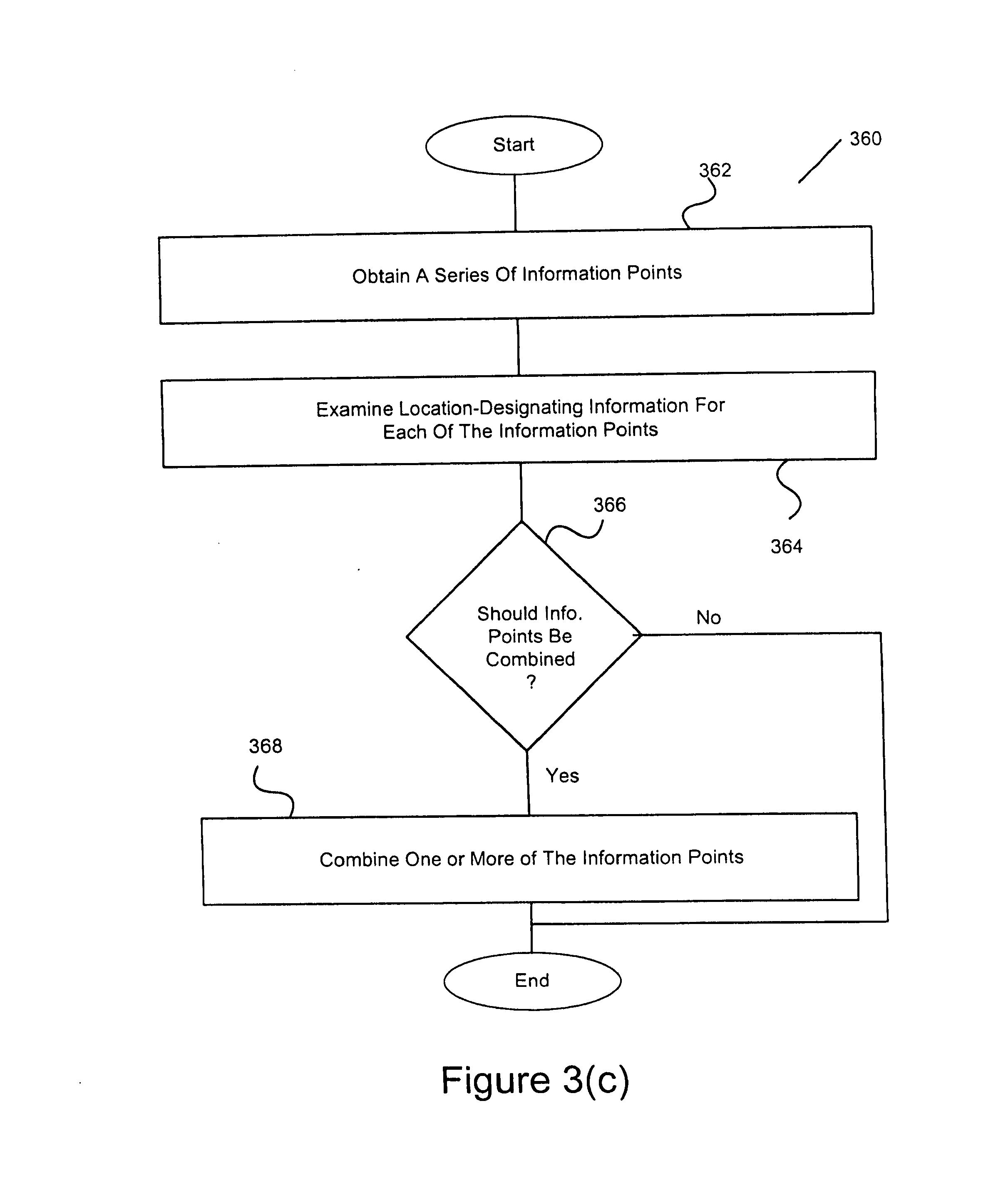
[0063] FIG. 3(c) is a flow diagram of consolidation processing 360 according to one embodiment of the invention. The consolidation processing 360 can be performed on a server or a client or a computing device in a peer-to-peer network.
[0064] The consolidation processing 360 initially obtains a series of information points 362. The series can be ordered based on the time each point is acquired. The series of information points are, for example, obtained from storage or directly from a mobile device. Each of the information points typically has location-designating information and location-related information. Next, the location-designating information for each of the information points is examined 364. A decision 366 then determines whether any of the information points should be combined. Here, in this embodiment, the decision 366 is based on the location-designation information for the information points. For example, if two consecutive location-designation information are substantially matched, the two information points should be combined. One rule regarding matching can be that if two consecutive location-designation information are close to each other, such as within 5 meters apart, they are considered as substantially matched. Another rule can be that if two consecutive pieces of location-designation information are in the same area, point of interest or label, they are considered substantially matched.
[0065] In another embodiment, the decision 366 can be based on not only the location-designation information but also the location-related information. If two consecutive pieces of location-designation information and location-related information are substantially matched, the two information points should be combined. Different thresholds can be set to determine if location-related information from different points are substantially matched. For example, the location-related information is the temperature of the environment. One rule can be that if the temperatures of two consecutive points are close to each other, such as setting the threshold to be 3 degrees, the location-related information from the two points are considered substantially matched. Another rule can be that if the difference between two consecutive pieces of location-related information is less than a certain percent, such as 3%, of the value of the first piece of location-related information, the two pieces of location-related information are considered substantially matched.
[0066] In any case, when the decision 366 determines that some of the information points should be combined, the two or more of the information points are combined 368. On the other hand, the information points are not combined when the decision 366 determines that these information points should not be combined.
[0067] Once information points are combined, the resulting information point can be a normal information point (with perhaps additional data) or a compound information point (retaining some or all of the data of the information points being combined). For example, information under each of the locations in Table 1 can be considered information under an information point. Information points 1-3 under Table 1 are combined into information point 1 under Table 2. The new information 1 can be considered a compound information point because it retains some of the time information of points combined. In any case, the combining of information points operates to consolidate the series of information points such that the data is more compact and/or better organized.
[0068] FIG. 4 shows examples of location-related information 250 regarding consolidation. For example, the location-related information can include temperature 252, humidity 254, direction, wind speed, time, user-input, chemicals, acceleration and pressure 256. Some of the location-related information is information regarding the environment where the location-designating device is located, such as temperature, humidity, wind speed, chemicals, and atmospheric pressure, tire pressure or other types of pressures. Other of the location-related information can pertain to the location-designating device itself, such as the acceleration of the device, or the pressure being asserted on the device. Examples of other sensors to provide related information include carbon monoxide detectors, liquid sensors, metal detectors, color sensors, scent sensors, light sensors, pattern sensors, tactile sensors, sound sensors, motion detectors, smoke sensors, particle sensors and radiation detectors, such as infrared detectors. Related information can be captured by the corresponding sensors, with the related-information coupled to location-designating information. The coupling can be achieved wirelessly. For example, a chemical sensor attached to a package can transmit the amount of certain gaseous chemicals through Bluetooth or WiFi technologies to the location-designating device, which is also coupled to the package.
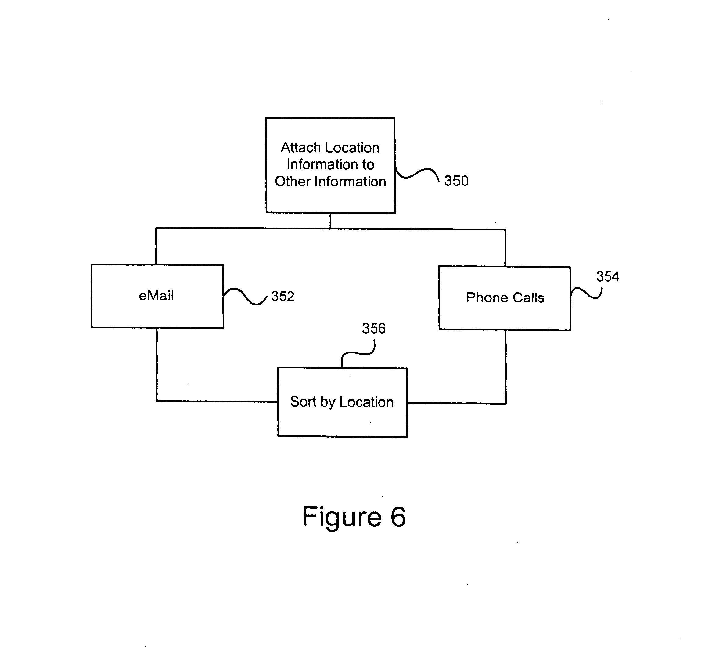
[0069] The following provides additional examples of location-related information that impact consolidation or compression, and are used in determining to retain location information 256. An administrator (e.g., user) can set a threshold for a location-related information. For example, a rule the administrator sets for the compressor can be: From position A to position B, if the temperature at any position changes by more than x degrees from that at point A, keep the location information at that position. Another rule can be: During any one-hour period, keep the location information where the humidity changes by, such as, more than 50% from that at the beginning of that hour. A third rule for a threshold can be that if time has elapsed by, such as, 1 hour, from the time when a piece of location information has been retained, keep the new location information. Another rule for a threshold can be that if a certain type of chemical exceeds a certain amount, keep the location information. Yet another rule can be that if a user has entered information at a specific location, keep the location information. In this case, the threshold can be set, for example, to zero or one character difference in user entry. If there is any changes in user entry, such as from not entering anything to inputting something, or to inputting something different, the location information at that position can be kept.
[0070] Location information collected can be attached to other information. FIG. 6 shows a few embodiments of attaching certain location information 350 to other information. For example, labels can be attached to emails 352, phone calls 354, or other types of messages, when they are sent. Then, received emails not only indicate who sent them, they would also indicate the locations from where they were sent. Emails and phone calls can then be sorted 356 based on locations. In one embodiment, the sorting can be alphabetical, such as through the labels.
[0071] To help users digest location information, sometimes it is advantageous to compare them to standards. In one embodiment, a system of the invention includes a comparator for comparing location information with standards. FIG. 6 shows examples of standards for comparison. In one example, a label represents a five-mile strip (portion) of a specific highway. The average amount of time T 302 to travel through that five-mile strip is known. The user drives his car through the strip. The time he enters and exits that label is stored, and their difference is compared to T. If the difference is more than a pre-set threshold, a notification can be sent to the user. Similarly, the standard can be the speed 304 of a typical car traveling through that strip.
[0072] In another example, the amount of time can be that of an item on the shelf of a company, such as a supermarket. The location of that item is monitored.
[0073] Standard deviations, 306, can also be tracked. This can be the standard deviation of the travel time of a specific car through the strip during the last two months. If the standard deviation is more than a pre-set threshold, the driver can be notified.
[0074] FIG. 7 shows embodiments related to the presentation 400 of location information. In one embodiment, location information can be presented chronologically on a map 402. Location-related information can be coupled to the corresponding labels and displayed on the map 404. For example, a piano is shipped from San Francisco to Toyko. The map can show chronologically where the piano is at different times. Next to the shipping path, there can be two other line graphs, one showing the humidity, and the other showing the temperature at the corresponding location and time. The location-related information can also be coupled to the corresponding labels and displayed as a link or visual indicator which is selectable to cause the location-related information to be displayed,
[0075] The presentation can be in a tabulated format, such as in a spreadsheet. Presentation can be in graphical formats, such as in bar charts or pie charts, in two or more dimensions.
[0076] Location information where a mobile device enters and exits a label can be presented. Location information where there are changes exceeding thresholds in location-related information can also be shown.
[0077] The display of location-related information can be through clickable icons 404 on a web site. For example, the user was in the Exploratorium at 4 pm. A small icon representing the Exploratorium can be displayed next to the location of the chart indicating where the user was at 4 pm. Clicking the icon would lead one to the web site of the Exploratorium.
[0078] Location information can be displayed with their standards 406. For example, a display can show the speed of a car as a function of location. Next to that, there can be another line showing standard speeds at the different locations.
[0079] In one embodiment, the display size can be modified 408. For example, the screen on a handheld device can be small. When the user is in a car, the user can dock the device, which can electronically couple the device to a larger screen in the car for viewing.
[0080] In another embodiment, the locations of a GPS device are displayed with respect to a specific location. The amount of details displayed between the locations of the GPS device and the specific location can dynamically change 410. This change can depend on the distances between the locations of the GPS device and the specific location. The amount of details can be defined as the density of the points of interest shown in an area. Points of interest can include the name of a street, the name of a park or other designations.
[0081] As an example, the number of labels shown between the locations of the GPS device and the specific location depends on the distances between the locations and the specific location. If the GPS device is very far away from the specific location, there will be many labels in between. With the display size being fixed, if all of the labels are shown, the display can be cluttered. So, very few labels should be shown. However, as the GPS device approaches the specific location, the ratio of labels being shown and the total number of labels between the locations increases. This can be done dynamically, depending on the separation distance. One way is to fix the number of labels to be shown on the display to be fewer than a predetermined number (e.g., 10). If there are more than the predetermined number of labels to be shown, certain labels can be skipped, such as every other one. If there are 100 labels, and only 10 can be shown, then every 10th label can be selected to be shown. In this example, even a label is in between the GPS device and the specific location, the label may not be displayed. In other words, whether a label between the location of the GPS device and the specific location is displayed or not depends on the distance between the location of the GPS device and the specific location. Note that whether a label is displayed or not can also depend on user preferences. The user can require a label to be shown if the label is between the location of the GPS device and the specific location.
[0082] In another example, the specific location is the location of another GPS device. That specific location can change as the other GPS device is moved.
[0083] Location information can be dynamically generated. As the GPS device moves, location information can be generated. So the presentation of location information can change as a function of time.
[0084] In a number of embodiments, a label identifies locations that are two-dimensional. However, a label can identify a three-dimensional volume. In other words, elevation coordinates can be included.
[0085] The present invention has described one or more GPS devices as location-designating devices to identify a location. However, the present invention is not limited to using one or more GPS devices to identify a location. In certain situations, other wireless or mobile devices can also serve as location-designating devices, such as devices based on GSM technologies or Wi-Fi technologies. Through the techniques of triangulation, these devices can also designate a location. Such triangulation techniques should be known to those skilled in the art.
[0086] Note that the process of transforming location coordinates into labels and the process of using additional information to help identify a location can be performed by two separate entities. In other words, a corporation can be responsible to transform location coordinates into labels. Then another corporation is responsible to clarify the location corresponding to a piece of location-designating information, using, for example, location-related information.
[0087] A number of embodiments have been described where the process of transforming location coordinates into labels or the process of compressing depends on a piece of location-related information. Note that such processes can depend on more than one piece of location-related information. Also, the multiple pieces of location-related information can be of different types. For example, the process of transforming can depend on time and a piece of information regarding the environment.
[0088] As described above, since multiple pieces of location information from a GPS device can identify direction 450, the GPS device can be used to calibrate a digital compass, 452, as illustrated in FIG. 8. A GPS device can provide multiple location information as a function of time. If the person carrying the device is traveling along a certain constant direction, the multiple location information will be able to identify that direction. The direction information can then be used to calibrate a digital compass, as long as the compass is attached to, or traveling in the same direction as, the GPS device.
[0089] The above-described systems, devices, methods and processes can be used together with other aspects of a monitoring system, including the various aspects described in: (i) U.S. Provisional Patent Application No. 60/444,198, filed Jan. 30, 2003, and entitled "SYSTEM, METHOD AND APPARATUS FOR ACQUIRING, PRESENTING, MONITORING, DELIVERING, MANAGING AND USING STATUS INFORMATION," which is hereby incorporated herein by reference; (ii) U.S. Provisional Patent Application No. 60/418,491, filed Oct. 15, 2002, and entitled "SYSTEM, METHOD AND APPARATUS FOR ACQUIRING, PRESENTING, MONITORING, DELIVERING, MANAGING AND USING STATUS INFORMATION," which is hereby incorporated herein by reference; (iii) U.S. Provisional Patent Application No. 60/404,645, filed Aug. 19, 2002, and entitled "SYSTEM, METHOD AND APPARATUS FOR ACQUIRING, PRESENTING, MONITORING, DELIVERING, MANAGING AND USING POSITION AND OTHER INFORMATION," which is hereby incorporated herein by reference; and (iv) U.S. Provisional Patent Application No. 60/375,998, filed Apr. 24, 2002, and entitled "SYSTEM, METHOD AND APPARATUS FOR ACQUIRING, PRESENTING, MANAGING AND USING POSITION INFORMATION," which is hereby incorporated herein by reference.
[0090] The various embodiments, implementations, features and aspects of the invention noted above (including those incorporated by reference) can be combined in various ways or used separately. Those skilled in the art will understand from the description that the invention can be equally applied to or used in other various different settings with respect to various combinations, embodiments, implementations or features provided in the description herein.
[0091] The invention can be implemented in software, hardware or a combination of hardware and software. The invention, or at least certain software portions of the invention, can also be embodied as computer readable code on a computer readable medium. The computer readable medium is any data storage device that can store data which can thereafter be read by a computer system. Examples of the computer readable medium include read-only memory, random-access memory, CD-ROMs, magnetic tape, optical data storage devices, and carrier waves. The computer readable medium can also be distributed over network-coupled computer systems so that the computer readable code is stored and executed in a distributed fashion.
[0092] Other embodiments of the invention will be apparent to those skilled in the art from a consideration of this specification or practice of the invention disclosed herein. It is intended that the specification and examples be considered as exemplary only, with the true scope and spirit of the invention being indicated by the following claims.
* * * * *
References
D00000
D00001
D00002
D00003
D00004
D00005
D00006
D00007
D00008
D00009
D00010
D00011
XML
uspto.report is an independent third-party trademark research tool that is not affiliated, endorsed, or sponsored by the United States Patent and Trademark Office (USPTO) or any other governmental organization. The information provided by uspto.report is based on publicly available data at the time of writing and is intended for informational purposes only.
While we strive to provide accurate and up-to-date information, we do not guarantee the accuracy, completeness, reliability, or suitability of the information displayed on this site. The use of this site is at your own risk. Any reliance you place on such information is therefore strictly at your own risk.
All official trademark data, including owner information, should be verified by visiting the official USPTO website at www.uspto.gov. This site is not intended to replace professional legal advice and should not be used as a substitute for consulting with a legal professional who is knowledgeable about trademark law.