Micro-geographic Aggregation System
Hickman; Andrew John ; et al.
U.S. patent application number 16/144230 was filed with the patent office on 2019-03-28 for micro-geographic aggregation system. The applicant listed for this patent is Experian Information Solutions, Inc.. Invention is credited to Andrew John Hickman, Shengjun Pan, Yaqi Tao, Alan Tsang.
| Application Number | 20190095939 16/144230 |
| Document ID | / |
| Family ID | 63761648 |
| Filed Date | 2019-03-28 |


| United States Patent Application | 20190095939 |
| Kind Code | A1 |
| Hickman; Andrew John ; et al. | March 28, 2019 |
MICRO-GEOGRAPHIC AGGREGATION SYSTEM
Abstract
The present disclosure describes systems and methods for automatically rolling-up data associated with one or more geographic units, such as ZIP+4 codes, such that the rollup comprises a minimum number of households to protect anonymity and ensure compliance with privacy regulations, while preserving variance of the underlying data associated with the geographic regions. Data attributes may include demographic data, socio-economic data, lifestyle segmentation, psychographic data, behavioral data, credit data, and other data. The rollup process may involve identifying one or more geographic units with a number of households below a minimum or threshold amount, applying filters to find candidate geographic units for rollup, scoring candidate geographic units to select best pairings for rollup, and repeating until the rollup group has at least the minimum number of households. The process may make trades off between granularity (e.g., number of households), proximity, and similarity of data attributes associated with each geographic unit.
| Inventors: | Hickman; Andrew John; (Summit, NJ) ; Tsang; Alan; (San Diego, CA) ; Tao; Yaqi; (San Diego, CA) ; Pan; Shengjun; (Sunnyvale, CA) | ||||||||||
| Applicant: |
|
||||||||||
|---|---|---|---|---|---|---|---|---|---|---|---|
| Family ID: | 63761648 | ||||||||||
| Appl. No.: | 16/144230 | ||||||||||
| Filed: | September 27, 2018 |
Related U.S. Patent Documents
| Application Number | Filing Date | Patent Number | ||
|---|---|---|---|---|
| 14244186 | Apr 3, 2014 | 10102536 | ||
| 16144230 | ||||
| 61905021 | Nov 15, 2013 | |||
| Current U.S. Class: | 1/1 |
| Current CPC Class: | G06Q 30/0205 20130101; G06Q 30/0201 20130101 |
| International Class: | G06Q 30/02 20120101 G06Q030/02 |
Claims
1. A computer-implemented method comprising: under control of a computing device configured with specific computer-executable instructions: accessing geographic attribute data associated with a target geographic unit and one or more rollup geographic units, the geographic attribute data accessed from a physical data store storing geographic data that includes household data attributes associated with respective geographic units, the household data attributes indicating at least a number of households associated with respective geographic units; identifying, from the one or more rollup geographic units, one or more candidate geographic units for potential rollup aggregation with the target geographic unit; applying one or more filter criteria to the one or more candidate geographic units to remove candidate geographic units which do not satisfy the filter criteria, wherein the filter criteria relate to one or more household data attributes associated with respective candidate geographic units and the target geographic unit; determining, for each remaining candidate geographic unit after application of the filter criteria, a score based at least in part on similarity of the household data attributes associated with each remaining candidate geographic unit and the target geographic unit; aggregating a best candidate geographic unit for rollup aggregation with the target geographic unit into a rollup group, wherein the best candidate geographic unit is selected based on the determined scores, and wherein the aggregating comprises at least determining a combined number of households associated with the rollup group as the sum of the respective number of households associated with each geographic unit in the rollup group; determining whether the combined number of households associated with the rollup group is below a minimum threshold; and in response to determining that the combined number of households associated with the rollup group is below the minimum threshold, determining a next best candidate geographic unit for rollup aggregation into the rollup group; or in response to determining that the combined number of households associated with the rollup group is not below the minimum threshold, providing the rollup group.
2. The computer-implemented method of claim 1, wherein determining the next best candidate geographic unit for rollup aggregation with the target geographic unit into the rollup group further comprises recursively repeating an indeterminate number of times, for the one or more rollup geographic units, the identifying one or more candidate geographic units for potential rollup aggregation, the applying one or more filter criteria to the one or more candidate geographic units, the determining scores for each remaining candidate geographic unit, the aggregating the next best candidate geographic unit for rollup aggregation with the target geographic unit, and the determining whether the combined number of households associated with the rollup group is below the minimum threshold, until the combined number of households associated with the rollup group is not below the minimum threshold.
3. The computer-implemented method of claim 1, wherein identifying one or more candidate geographic units for potential rollup aggregation with the target geographic unit comprises: determining a geographic location for the target geographic unit, based at least in part on the accessed geographic unit attribute data; and identifying the one or more candidate geographic units, wherein each candidate geographic unit is within a radial distance of the geographic location, based at least in part on geographic data associated with the each candidate geographic unit.
4. The computer-implemented method of claim 1, wherein the geographic location comprises a latitude longitude bounded area.
5. The computer-implemented method of claim 1, wherein the household data attributes include one or more socio-economic and/or lifestyle segment attributes.
6. The computer-implemented method of claim 5, wherein the socio-economic attributes include an average asset value per household within the respective geographic unit.
7. The computer-implemented method of claim 5, wherein the lifestyle segment attribute is a MOSAIC.RTM. segment code.
8. The computer-implemented method of claim 1, wherein each candidate geographic unit is a ZIP+4 code.
9. The computer-implemented method of claim 1, wherein the one or more filter criteria further are received from a requesting entity.
10. The computer-implemented method of claim 9, wherein the one or more filter criteria are received from the requesting entity via a web user interface, and wherein the web user interface provides one or more input fields enabling the requesting entity to configure custom filter criteria for the rollup group.
11. The computer-implemented method of claim 1, wherein determining the score for each remaining candidate geographic unit further comprises: identifying one or more target attributes on which to analyze the similarity of each remaining candidate geographic unit to the target geographic unit, wherein the target attributes are selected from the household data attributes; calculating, for each remaining candidate geographic unit, a weighted similarity of the remaining candidate geographic unit to the target geographic unit based on a comparison of the target attributes; and determining the score based at least in part on the weighted similarity.
12. The computer-implemented method of claim 11, wherein the weighted similarity is calculated based at least in part on a calculated geographic distance between the remaining candidate geographic unit and the target geographic unit.
13. A computer system comprising: an electronic data store configured to at least store geographic data associated with each of a plurality of geographic units; and a computing system comprising one or more hardware computing devices, said computing system in communication with the electronic data store and configured to at least: access, from the electronic data store, geographic attribute data associated with a target geographic unit and one or more rollup geographic units, the geographic attribute data including household data attributes associated with each respective geographic unit, the household data attributes indicating at least a number of households associated with each respective geographic unit; identify, from the one or more rollup geographic units, one or more candidate geographic units for potential rollup aggregation with the target geographic unit; apply one or more filter criteria to the one or more candidate geographic units to remove candidate geographic units which do not satisfy the filter criteria, wherein the filter criteria relate to one or more household data attributes associated with respective candidate geographic units and the target geographic unit; determine, for each remaining candidate geographic unit after application of the filter criteria, a score based at least in part on similarity of the household data attributes associated with each remaining candidate geographic unit and the target geographic unit; aggregate a best candidate geographic unit for rollup aggregation with the target geographic unit into a rollup group, wherein the best candidate geographic unit is selected based on the determined scores, and wherein the aggregating comprises at least determining a combined number of households associated with the rollup group as the sum of the respective number of households associated with each geographic unit in the rollup group; and in response to determining that the combined number of households associated with the rollup group is not below a minimum threshold, providing the rollup group.
14. The computer system of claim 13, wherein the computing system is further configured to: in response to determining that the combined number of households associated with the rollup group is below the minimum threshold, determining a next best candidate geographic unit for rollup aggregation into the rollup group.
15. The computer system of claim 13, wherein each candidate geographic unit is a ZIP+4 code.
16. Non-transitory physical computer storage comprising computer-executable instructions stored thereon that, when executed by a hardware processor, are configured to perform operations comprising: accessing, from a physical data store storing at least geographic data, geographic attribute data associated with a target geographic unit and one or more rollup geographic units, the geographic attribute data including household data attributes associated with each respective geographic unit, the household data attributes indicating at least a number of households associated with each respective geographic unit; identifying, from the one or more rollup geographic units, a candidate geographic unit for potential rollup aggregation with the target geographic unit; applying filter criteria to the one or more candidate geographic units to remove candidate geographic units which do not satisfy the filter criteria, wherein the filter criteria relate to one or more household data attributes associated with respective candidate geographic units and the target geographic unit; determining, for each remaining candidate geographic unit after application of the filter criteria, a score based at least in part on similarity of the household data attributes associated with each remaining candidate geographic unit and the target geographic unit; aggregating a best candidate geographic unit for rollup aggregation with the target geographic unit into a rollup group, wherein the best candidate geographic unit is selected based on the determined scores, and wherein the aggregating comprises at least determining a combined number of households associated with the rollup group as the sum of the respective number of households associated with each geographic unit in the rollup group; and responsive to determining that the combined number of households associated with the rollup group is not below a minimum threshold, providing the rollup group.
17. The non-transitory physical computer storage of claim of claim 16, the operations further comprising: in response to determining that the combined number of households associated with the rollup group is below the minimum threshold, determining a next best candidate geographic unit for rollup aggregation into the rollup group.
18. The non-transitory physical computer storage of claim of claim 17, wherein determining the next best candidate geographic unit for rollup aggregation with the target geographic unit into the rollup group further comprises recursively repeating an indeterminate number of times, for the one or more rollup geographic units, the identifying one or more candidate geographic units for potential rollup aggregation, the applying one or more filter criteria to the one or more candidate geographic units, the determining scores for each remaining candidate geographic unit, the aggregating the next best candidate geographic unit for rollup aggregation with the target geographic unit, and the determining whether the combined number of households associated with the rollup group is below the minimum threshold, until the combined number of households associated with the rollup group is not below the minimum threshold.
19. The non-transitory physical computer storage of claim of claim 16, wherein the household data attributes include one or more socio-economic and/or lifestyle segment attributes.
20. The non-transitory physical computer storage of claim of claim 16, wherein each candidate geographic unit is a ZIP+4 code.
Description
CROSS-REFERENCE TO RELATED APPLICATIONS
[0001] This application is a continuation of U.S. patent application Ser. No. 14/244,186, filed Apr. 3, 2014, which claims the benefit of priority under 35 U.S.C. .sctn. 119(e) of U.S. Provisional Application No. 61/905,021, filed Nov. 15, 2013, the disclosure of which is hereby incorporated by reference in its entirety.
BACKGROUND
[0002] Geographic aggregation is a common approach to creating anonymous data from individual consumer or household data that may otherwise be too private to disclose. Units of geographic aggregation can be based on a variety of classification schemes with different levels of granularity, for example state, county, city or neighborhood.
SUMMARY
[0003] Postal codes are a popular choice for geographic aggregations, both for granularity and ease of use for marketing applications. In the United States, the US Postal Service assigns each deliverable address both a 5-digit "ZIP Code.TM." as well as a 9-digit, ZIP+4 code (or "ZIP9"), the latter generally defined in terms of a street address range. Many of these ZIP9 codes encompass only a small number of unique households. However, to protect privacy, a number of policies, rules and regulations have been enacted which may limit or restrict the use of data for ZIP9 codes which include too few households. The high degree of segmentation contributes to more variance in demographic, socio-economic, behavioral, and other data associated with ZIP and ZIP9 codes. Such variance in the data set may be desirable to some entities, such as marketers and certain consumers, who value targeted offers and advertising.
[0004] The present disclosure describes systems and methods for automatically combining or "rolling-up" data associated with one or more geographic region codes, in particular ZIP9 codes, such that the combination or "rollup" satisfies a minimum threshold of granularity (e.g., a minimum number of households) to protect anonymity and ensure compliance with privacy regulations or policies, while preserving variance of the underlying data associated with the geographic regions.
[0005] Some approaches to protect anonymity and ensure compliance with privacy regulations may involve suppressing or removing certain data which do not comply with privacy rules (e.g., by removing a "non-compliant" ZIP9 from a data set, wherein the non-compliant ZIP9 has a number of households less than a required minimum). Other approaches may involve applying default values to non-compliant ZIP9s, or analyzing data at a different ZIP-level which more frequently satisfies minimum number of household requirements, such as the 5-digit ZIP code or the first 7 digits of the ZIP+4 code.
[0006] However, such approaches may have drawbacks which can include less accurate overall data, loss of granularity, and/or loss of variance which may be of interest in certain cases where specificity of data carries high value, such as in direct-mail marketing campaigns and similar targeted advertising efforts. This may be particularly true when certain data attributes associated with a particular ZIP9 are skewed, such as the case may be with respect to household wealth which is correlated to ZIP9s having smaller number of households. Thus, in some cases more granular data (e.g., at the ZIP9 level or as close to the ZIP9 level as permissible to maintain privacy and anonymity) is not only more valuable, but may even be essential in order to provide an indication of useful information that data at the ZIP5 or ZIP7 level do not provide.
[0007] The methods and processes described in the present disclosure provide an algorithm for rolling-up ZIP9 codes that trades off between granularity (e.g., to keep the number of households in a rolled-up ZIP9 group as small as possible), proximity (e.g., to group ZIP9s which are within a certain geographic distance of each other as much as possible given other constraints and criteria), and/or similarity of data attributes associated with each ZIP9. Data attributes may include, but are not limited to, demographic data, socio-economic data, psychographic data, behavioral data, credit data including aggregated and/or anonymized credit statistics, wealth data, and/or other similar types of data. One example of socio-economic data or lifestyle segmentation which will be referred to in examples throughout this disclosure is Experian's MOSAIC.RTM. service; however, any other segmentation data may be used as data attributes for identifying similar ZIP9s or households.
[0008] At a high level, the rollup process executed by the micro-geographic aggregation system 100 operates by identifying one or more geographic units (e.g., ZIP codes, ZIP5s, ZIP7s, ZIP9s, census tract data, street address ranges, grid-based geographic regions corresponding to a map, and any other finite geographic area) having a number of households below a minimum or threshold amount. Then, data filters may be applied in order to find or determine which geographic units are candidates for rollup. For example, data filtering may be applied to filter out or remove ZIP9s which are dissimilar based on one or more attributes (e.g., average assets, MOSAIC.RTM. code, and so on). Once the geographic unit candidates are identified, the rollup process scores the candidates and selects one or more with the best scores for rollup or pairing. For example, the candidate ZIP9s may be scored relative to a target ZIP, ZIP7, ZIP9 or relative to each other (e.g., pairwise) in order to identify strong potential for rollup (e.g., combination or grouping of two or more ZIP9s). Once a rollup group has been created, identified, or updated, the rollup process combines the number of households for each constituent geographic unit to determine a number of households in the rollup group. If the number of households in the rollup group is less than the minimum or threshold amount, the rollup process may repeat recursively or indefinitely until the identified geographic units have been rolled up into respective rollup groups with at least the minimum number of households.
[0009] The rollup algorithm or processes described herein can be applied to any set of one or more target variables and one or more explanatory variables relating to ZIP data attributes, such that as ZIP9s are evaluated for possible combination in a rollup, the similarity and/or trade-offs between associated target variables and associated explanatory variables are weighted. The examples herein will use average assets as an example target variable, and MOSAIC.RTM. codes as an example explanatory variable. However, in general any type of target variable and/or explanatory variable may be used, depending on the embodiment, the particular context, and/or a particular request from a requesting entity. A target variable is generally understood to be a continuous variable such as a specific number or amount, while an explanatory variable may generally be a category or classification variable which may represent, for example, general characteristics or attributes of members of the category or classification which may not correspond directly to a numeric value.
[0010] The micro-geographic aggregation system may apply the rollup process to data of different granularities, for different geographic regions, across a wide variety of data attributes. The micro-geographic aggregation system may provide a requesting entity with the ability to dynamically query consumer data on the fly in a customized manner, simultaneously obscuring private data to protect anonymity while providing high-value and insightful data for use in intelligent and customized marketing. While ZIP9s are discussed herein, the systems and methods discussed herein are equally applicable to other geographic unit comprising groupings of households or individuals.
BRIEF DESCRIPTION OF THE DRAWINGS
[0011] FIG. 1 is a map illustrating one example of challenges posed by ZIP9 fragmentation for a small geographic region which the geographic unit rollup processes described herein are designed to address.
[0012] FIG. 2 is a flowchart of a process for rolling up one or more geographic units, such as ZIP9 codes, together into a rollup group, using the micro-geographic aggregation system of FIG. 8.
[0013] FIG. 3 is a flowchart of a process for combining one or more geographic units, such as ZIP9 codes, together into one or more rollup groups, using the micro-geographic aggregation system of FIG. 8.
[0014] FIG. 4 is a flowchart of a process for identifying, scoring and selecting one or more geographic units, such as ZIP9 codes, for inclusion in a rollup group, using the micro-geographic aggregation system of FIG. 8.
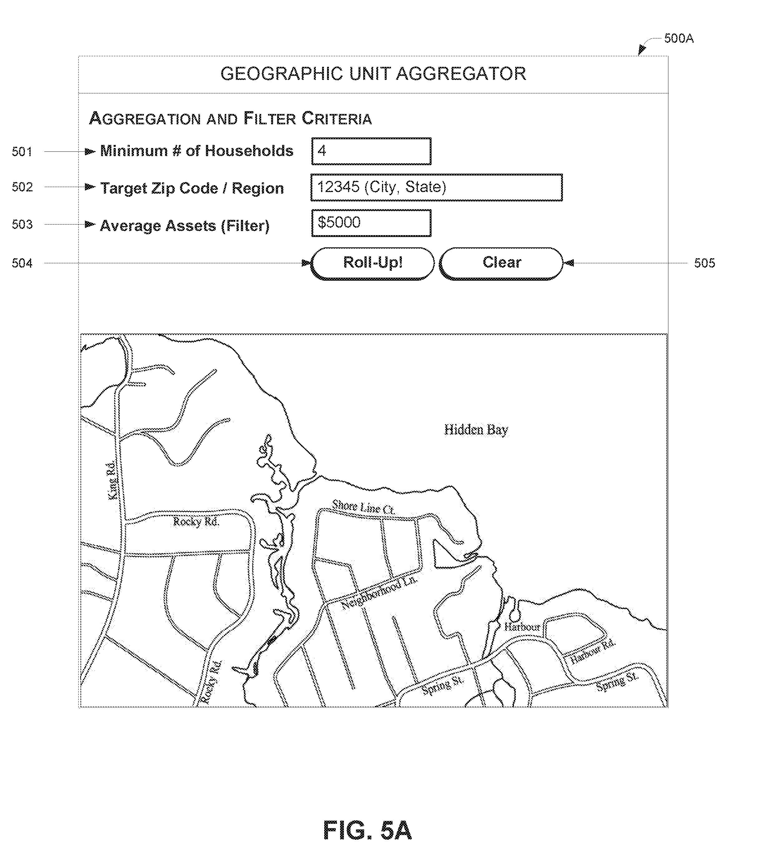
[0015] FIG. 5A illustrates an example user interface which enables an end user, such as a third party requesting entity, to submit customized rollup filters and data requests, as generated using the micro-geographic aggregation system of FIG. 8.
[0016] FIG. 5B illustrates an example user interface which enables an end user, such as a third party requesting entity, to view rollup maps and/or output lists generated in response to a rollup request, as using the micro-geographic aggregation system of FIG. 8.
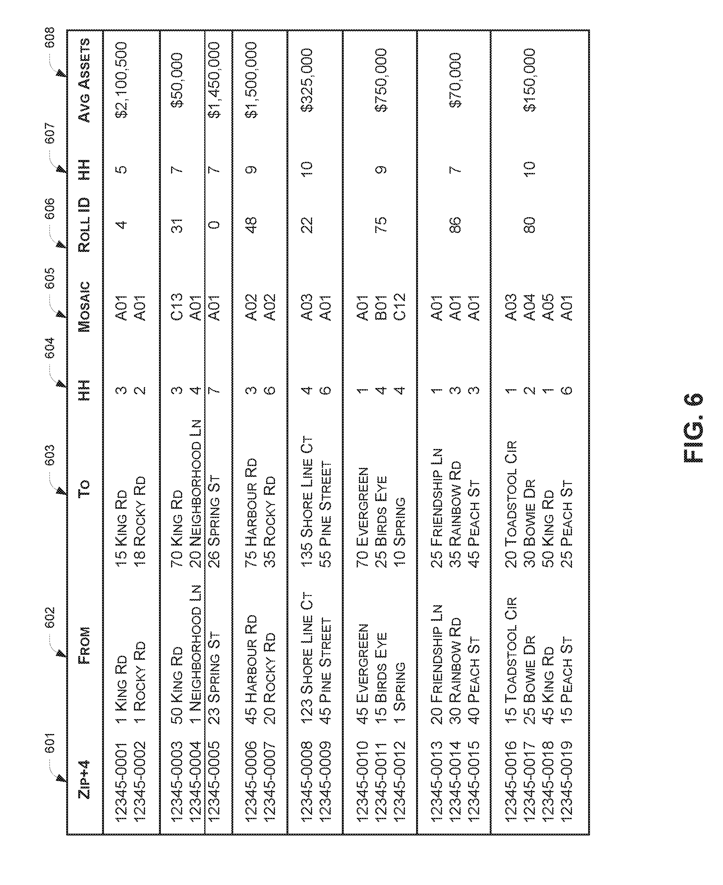
[0017] FIG. 6 illustrates an example geographic unit rollup output which may be provided by the rollup processes described herein, using the micro-geographic aggregation system of FIG. 8.
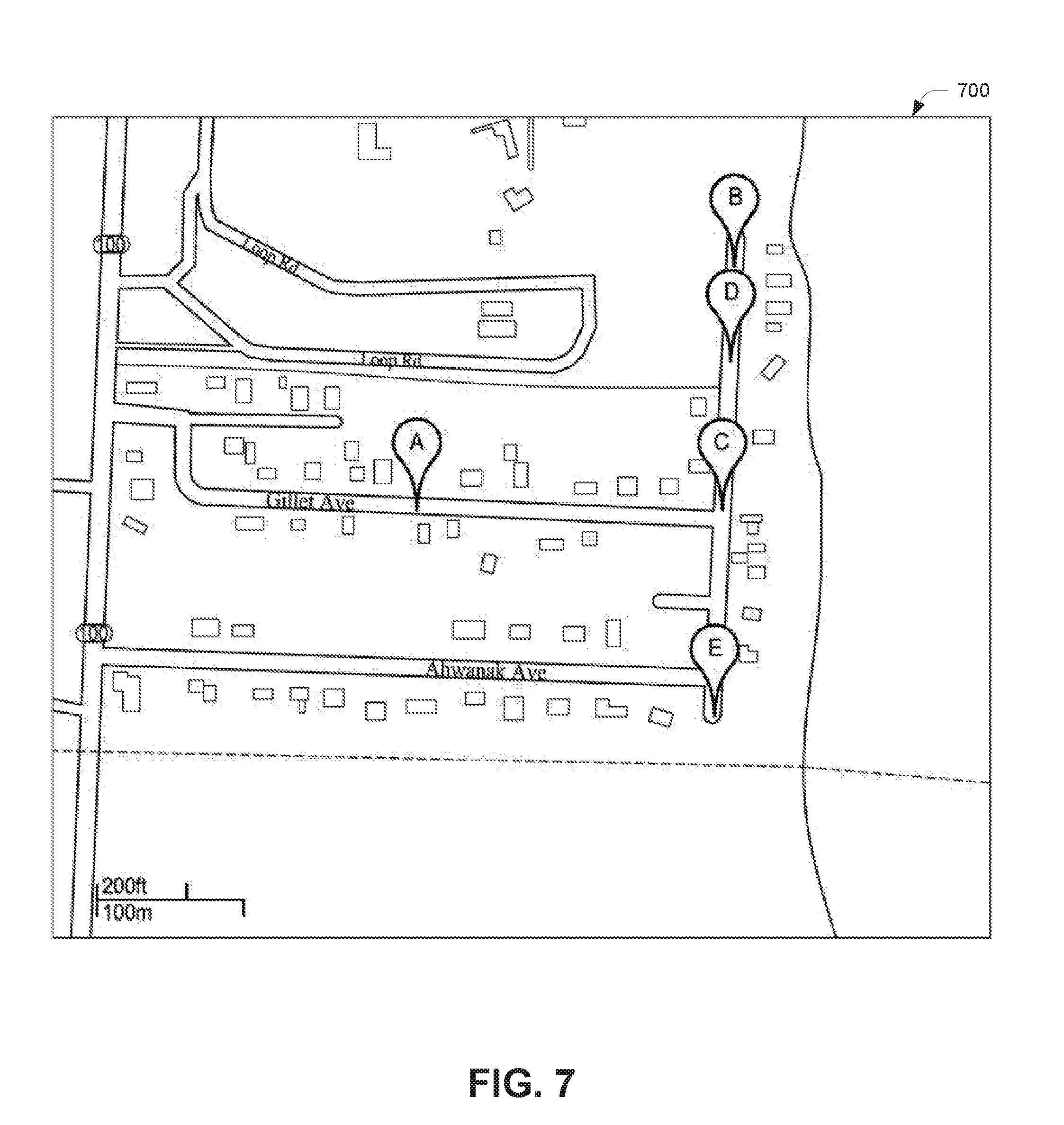
[0018] FIG. 7 illustrates an example of how different map data sources may have different and/or conflicting map latitude/longitude ("lat/long") coordinates for geographic units, such as ZIP codes, which may need to be reconciled to improve accuracy of a geographic unit rollup process.
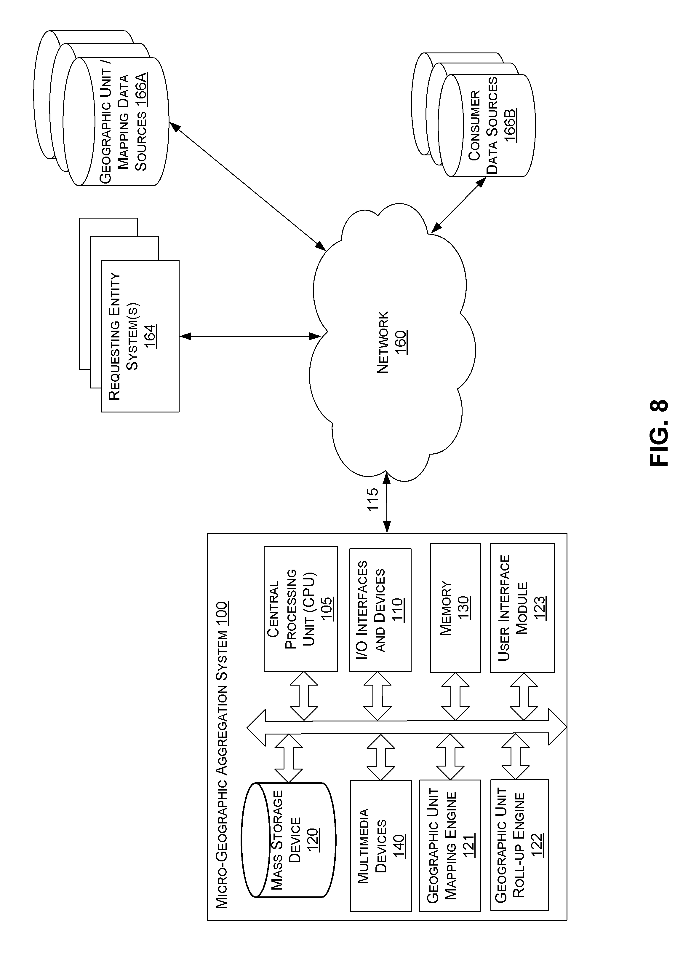
[0019] FIG. 8 is a block diagram of an implementation of an illustrative micro-geographic aggregation system.
DETAILED DESCRIPTION
[0020] Embodiments of a micro-geographic aggregation system will now be described with reference to accompanying figures, wherein like numerals refer to like elements throughout. The terminology used in the description presented herein is not intended to be interpreted in any limited or restrictive manner, simply because it is being utilized in conjunction with a detailed description of certain specific embodiments of the disclosure. Furthermore, embodiments of the disclosure may include several novel features, no single one of which is solely responsible for its desirable attributes or which is essential to practicing the embodiments of the disclosure herein described.
Overview
[0021] Generally described, a micro-geographic aggregation system is a computer system that automatically and optimally determines combinations, aggregations, or "rollups" of geographic units, such as ZIP9 codes, in order to satisfy a minimum or threshold number of households which may be required, for example, to preserve anonymity of the constituent households associated with each ZIP code.
[0022] One example embodiment of a micro-geographic aggregation system is the micro-geographic aggregation system 100 shown in FIG. 8. The micro-geographic aggregation system 100 may include one or more sub-systems, engines, or modules such as a geographic unit mapping engine 121, a geographic unit rollup engine 122, and/or a user interface module 123, configured to perform the methods and processes described herein. The micro-geographic aggregation system 100 may also access or be in communication with one or more data sources, including geographic unit/mapping data sources 166A and/or consumer data sources 166B. Each of these systems and components is described in more detail with reference to FIG. 8 herein.
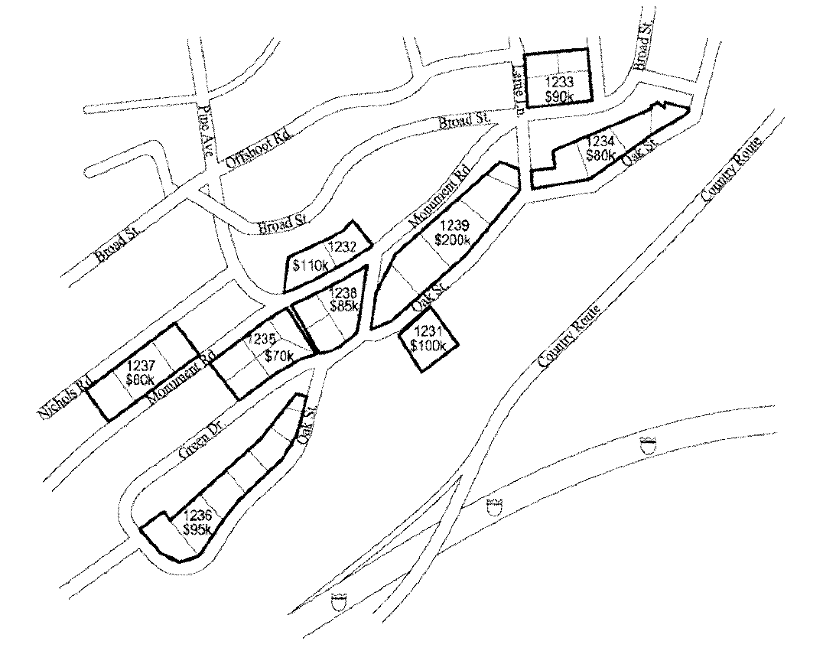
[0023] FIG. 1 is an example map that illustrates certain challenges posed by geographic units (e.g., ZIP9s) of disparate size and other characteristics for a small geographic region which the geographic unit rollup processes described herein are designed to address. The map shows several ZIP9 area codes for a particular region, each of which has been outlined to show the varying number of households within each ZIP9. Corresponding to each ZIP9 is an average quantity of assets for that ZIP9 (which may be known, for example, based on consumer level data accessed from the consumer data source 166B). Such granular data may be of particular interest to an investment company, for example, which may want to target particular ZIP codes or households within a certain asset range or above a certain asset threshold. However, as the map of FIG. 1 shows, many of these ZIP9 codes include less than four households, and in some cases only one or two households. To protect the privacy of these households, while preserving the value in the data variance across ZIP9 codes in this region, the micro-geographic aggregation system 100 can analyze attributes of the ZIP9 codes in the area, identify potential ZIP9 codes for combination based on similarity, and rollup these ZIP9 codes into a rollup group which meets a minimum number of households threshold and with similar average assets and/or other attributes. Thus, for example in FIG. 1, ZIP9 codes 1231 (one household, $100K assets), 1232 (two households, $110K average assets), and 1233 (three households, $90K average assets) may be rolled up to create a rollup group with a combined household total of six and an average asset attribute of $98K. ZIP9 codes 1237 (three households, $60K average assets) and 1238 (three households, $85K assets) also might be eligible for rollup if the minimum number of households is four; however, these ZIP9s may not be rolled up together in some instances if, for example, the difference in average assets (e.g., $85k vs $60k) is relatively too high to be considered similar enough for rollup grouping. This determination will depend on the particular embodiment or implementation of the rollup algorithm and various criteria for filtering and rollup that are applied. Or, in alternate example, ZIP9s 1233 and 1238 might be considered for possible rollup together since they have similar average assets values ($90k and $85k respectively). FIG. 1 also illustrates a couple of ZIP9s (e.g., 1236 and 1239) with at least five households, and thus these ZIP9s may not need to be rolled-up or aggregated in cases where the minimum number of households is five. Instead, each of these ZIP9s may not be rolled up or, in one embodiment, may be assigned to a rollup "group" which comprises only the respective ZIP9 (e.g., a "singleton").
Examples of Methods Performed by a Micro-Geographic Aggregation System
[0024] FIGS. 2, 3, and 4 are flowcharts for various embodiments of micro-geographic aggregation system processes. In some implementations, the processes are performed by embodiments of the micro-geographic aggregation system 100 described with reference to FIG. 8 or by one or more of its components, such as the geographic unit mapping engine 121, geographic unit rollup engine 122, and/or user interface module 123. The example scenarios are intended to illustrate, but not to limit, various aspects of these systems and/or services. In one embodiment, the processes can be dynamic, with some procedures omitted and others added. In one example, multiple instances of the processes may occur concurrently, for different micro-geographic aggregation systems. Depending on the embodiment, the methods may include fewer or additional blocks and/or the blocks may be performed in an order different than illustrated.
[0025] FIG. 2 is a flowchart illustrating one embodiment of a high-level process 200 for combining one or more geographic units, such as ZIP codes, together into a rollup group. The process 200 may be executed, for example, by the geographic unit rollup engine 122 of the micro-geographic aggregation system 100 of FIG. 8.
[0026] At block 205, the micro-geographic aggregation system 100 identifies, from a set of geographic data, one or more geographic units with a number of households below a minimum threshold, such as within a geographic area of interest (e.g., a city or state that is the target of a marketing campaign) to a company that is requesting geographically aggregated data. For example, the minimum threshold may be a value provided by a requesting entity or client using the micro-geographic aggregation system 100. The minimum threshold may also be a minimum required by government (e.g., Federal, state, municipality, etc.) rules and regulations, including consumer privacy regulations. The one or more geographic units may also be identified based on proximity to each other or to a geographic unit that has been selected for potential rollup, or based on other attributes as will be discussed in more detail herein. As a specific example, at block 205 the micro-geographic aggregation system may find 5 ZIP9 codes with 5 or fewer households per ZIP9.
[0027] At block 210, the micro-geographic aggregation system 100 applies filters to the set of geographic data and the geographic units in order to find candidates for potential rollup or aggregation. Filters may be applied, for example, in order to remove those candidate ZIP codes which are not close enough in proximity (e.g., geographic distance), not similar enough based one or more attributes of interest (e.g., average assets per household, lifestyle characteristics or attributes as reflected in, for example, a MOSAIC.RTM. code, etc.), or on other criteria. In some embodiments, the filters may be accessed from the data sources 166A or 166B, or otherwise be preconfigured by the micro-geographic aggregation system 100. In another embodiment, such as the example process 300 illustrated and described with reference to FIG. 3 herein, the filters may be accessed from or provided by a requesting entity system 164 as part of a rollup request.
[0028] At block 215, the micro-geographic aggregation system 100 scores each of the candidate geographic units in order to select the best candidate for a rollup group. Scoring of the candidate geographic units may be performed a number of different ways depending on the embodiment or implementation. The scoring may be performed relative to a target or base reference geographic unit (or a rollup group), such that each candidate may be compared on the same basis. One example of how the scoring may be performed is discussed in further detail herein with respect to block 435 of FIG. 4. In one embodiment, more than one candidate may be selected. For example, to improve speed or efficiency of processing, the two best scoring candidates may be selected for inclusion in a rollup group. Once the best scoring candidate(s) have been selected, the candidate(s) are combined with the base reference geographic unit to form a new rollup group, or added to a base reference rollup group if one exists.
[0029] At block 220, the micro-geographic aggregation system 100 determines whether the rollup group has a combined number of households below the minimum threshold. In response to a determination that the number of households in the rollup group is still below the minimum threshold, the process 200 returns to block 205 to repeat block 205 to block 220. In response to a determination that the number of households in the rollup group is above or equal to the minimum threshold, the process 200 can proceed to block 225.
[0030] At block 225, the micro-geographic aggregation system 100 provides the rollup group as output, for example to another process of the micro-geographic aggregation system 100 or to a requesting entity system 164. For example, after the rollup process is finished, a rollup ID (or "roll ID") of "0" may be assigned to each ZIP9 that did not need grouping (e.g., a singleton) to indicate that the singleton is not associated with any rollup group. Then, the output may be provided in a number of different formats. For example, in one embodiment, the list may be provided as a list of ZIP9's and associated roll IDs, along with one or more attributes or metrics of interest for the ZIP9 (e.g., average assets per household, number of households, MOSAIC.RTM. code, etc.). In another embodiment, the list may be provided as a list of roll IDs with a list of one or more associated ZIPs in the rollup group, along with one or more attributes or metrics of interest or related to the rollup (e.g., average assets for the group, total number of households for the group, MOSAIC.RTM. code(s) for the group, etc.). One example of a rollup output is illustrated and described with reference to FIG. 6 herein.
[0031] FIG. 3 is a flowchart illustrating one embodiment of a high-level process 300 for combining one or more geographic units (e.g., ZIP9 codes) together into a rollup group. The process 300 may be executed, for example, by the geographic unit rollup engine 122 of the micro-geographic aggregation system 100 of FIG. 8.
[0032] The process 300 involves similar routines as those described with reference to process 200 of FIG. 2, but presents alternatives which may be implemented in some embodiments of the micro-geographic aggregation system 100. For example, process 300 involves receiving one or more filter parameters or criteria, such as from a requesting entity system 164, related to ZIP code attributes (e.g., at block 310). The filters may be applied in a similar process as described at block 210 of FIG. 2, but the example process 300 illustrates how these filters may be custom filters provided by a third party requesting entity, such as a company that wishes to obtain aggregated or rolled-up ZIP9 data based on filter criteria or business rules which are tailored to, for example, its particular type of business or its particular business requirements. For example, an investment or financial services firm might be interested in filtering ZIP9 data based on certain financial metrics like average assets per household, average debt/liabilities per household, and the like. Or, in another example, a credit account servicing firm (e.g. a credit card company) might be interested in filtering ZIP9 data based on certain metrics like average credit score per household, average number of pre-college or post-college children per household, and the like. The micro-geographic aggregation system 100 may be configured to enable all such examples of custom filtering via the process 300.
[0033] In some embodiments, filters and/or filter criteria may not be used at all, for example depending on the number of candidate ZIP codes identified for potential rollup. For example, if a small number of candidate geographic units are identified, it may be unnecessary or undesirable to filter the list and instead score each candidate in an unfiltered list. If a large number of candidate geographic units are identified, it may be necessary or desirable to filter the list and score only a subset of the candidates. For example, in some embodiments, the number of candidate geographic units may number in the hundreds, thousands, or more, and therefore filtering the list may be of particular benefit to improve speed and efficiency due to the overall complex and computationally intense rollup aggregation process. To further illustrate these alternative embodiments, the process 300 of FIG. 3 omits the optional filtering routine (e.g., applying filters as described in other embodiments, such as at block 210 of FIG. 2 or at block 430 of FIG. 4).
[0034] At block 305, the micro-geographic aggregation system 100 accesses a list of target geographic units and related attribute data for potential rollup aggregation. In one embodiment, the list of target geographic units may be accessed from geographic unit/mapping data source 166A. Related ZIP code attribute data may be accessed from the consumer data source 166B, which may store for example consumer and/or socio-economic data associated with the geographic units. In another embodiment, the list of target geographic units may be provided by a requesting entity, for example as part of request to perform a rollup operation. The list of target geographic units may be, for example, one or more ZIP9 codes, each of which has a number of households below a threshold.
[0035] At block 310, the micro-geographic aggregation system 100 receives one or more filter parameters related to the geographic units' attribute data. For example, the filters may be accessed from or provided by a requesting entity system 164 as part of a rollup request.
[0036] At block 315, the micro-geographic aggregation system 100 selects a target geographic unit from the list for rollup aggregation. In one embodiment, before the target geographic unit is selected from the list, the list may be sorted by one or more sorting criteria to facilitate processing of the list. For example, the list of targets may be sorted by the number of households in each target geographic unit with the smallest number at the top of the list. This would then ensure that the rollup algorithm would first attempt to rollup those geographic units with the smallest number of households.
[0037] At block 320, the micro-geographic aggregation system 100 determines a rollup group comprising one or more geographic units for rollup aggregation with the target geographic units. This rollup process may be performed, for example, by the process 400 illustrated and described in more detail with reference to FIG. 4 herein.
[0038] At block 325, the micro-geographic aggregation system 100 determines whether there are additional target geographic units in the list to rollup. In response to a determination that there are additional target geographic units in the list to rollup, the process 300 returns to block 315 and the micro-geographic aggregation system 100 selects the next target from the list for rollup. If there are not additional targets in the list to rollup, the process 300 may proceed to block 330.
[0039] At block 330, the micro-geographic aggregation system 100 provides the rollup group or groups as output, for example to another process of the micro-geographic aggregation system 100 or to a requesting entity system 164. This process is similar to the process described at block 225 of process 200 shown in FIG. 2 herein.
[0040] FIG. 4 is a flowchart illustrating one embodiment of a process 400 for combining one or more geographic units, such as ZIP9 codes, together into a rollup group. The process 400 may be executed, for example, by the geographic unit rollup engine 122 of the micro-geographic aggregation system 100 of FIG. 8. The process 400 may be for example a sub-routine which is invoked as part of the process 300 of FIG. 3, for example at block 320, to execute a particular embodiment of the rollup process. In particular, the process 400 includes several decision blocks and alternative approaches to perform the rollup depending on the underlying ZIP code data, the number of ZIP codes found matching various rollup conditions (e.g., proximity, granularity, filter criteria or conditions for attribute data associated with the geographic units, and so on). Depending on the particular embodiment, the process 400 may be performed independently from the process 300, separately or in parallel to process multiple geographic unit rollups for a plurality of candidate geographic units.
[0041] At block 405, the micro-geographic aggregation system 100 determines or identified one or more candidate geographic units (e.g., ZIP9 codes) within a geographic distance of a selected target ZIP code. In one implementation, the geographic distance may be set or preconfigured to a certain radius that may be optimal based on the geographic region of the selected target geographic unit. For example, the geographic distance may be larger if the target is in a remote or rural geographic location that is likely to have a small number of candidates within a large area. Or, the geographic distance may be smaller if the target is in a densely populated geographic location that is likely to have a large number of candidates within a small area. The geographic distance may also be based on other conditions such as the average number of geographic units within different radius values. In one example embodiment, the geographic distance may initially be set to 0.75 miles. The micro-geographic aggregation system 100 may access data from geographic unit/mapping data source 166A in order to identify all ZIP9 codes within the geographic distance of the selected target ZIP9 code, and use the identified ZIP9 codes as candidates for rollup or aggregation with the selected target ZIP9 code.
[0042] Finding all geographic units within a geographic distance of a selected target geographic unit may be done in various ways. In one embodiment, a two-step block search approach may be used to efficiently find all ZIP9s for a given radius. First, given the latitude/longitude coordinates for the lower left (A) and upper right corner (B) of the United States, create a grid with 1.degree. latitude.times.1.degree. longitude blocks. Then, for each 1.times.1 block, find all the ZIP9's that belong to or fall within the block to create a mapping or index of ZIP9s-to-blocks. For ZIP9s which overlap more than one block, the ZIP9 may be assigned to the block with the greatest degree of overlap. This information may be saved for use in subsequent block searches and need not be repeated every time. Second, to find all ZIP9's within a certain distance of a given ZIP code, from the given ZIP code's latitude/longitude coordinates and radius R, calculate the latitude/longitude coordinates for the lower left (C) and upper right (D) corner of a bounding box on the grid. Then, the index of the blocks to which points C&D belong may be used to determine which ZIP9s are within the given radius, based on the mapping of ZIP9s-to-blocks created before. The initial search range could then be confined to the only the blocks within the C&D index instead of the whole universe of ZIP9's across the United States.
[0043] In one embodiment, at block 405 the micro-geographic aggregation system 100 may also, or instead, determine one or more candidate ZIP9 rollups within the geographic distance of the selected target ZIP9 code. This may be the case, for example, if and when the process 400 iteratively repeats block 405 through block 445 to generate rollups dynamically using a "local optimum" or "greedy" algorithm approach. For example, on a first iteration of the process 400, a candidate ZIP9 code list might include three ZIP9 codes with a number of households equal to 1, 2, and 3. At the end of a first iteration, the first candidate ZIP9 code may be selected for inclusion in a rollup with the selected target ZIP9 code, and the rollup may be added back to the candidate list for further potential rollup (e.g., if the combined number of households in the rollup is still less than the minimum threshold). Then, on a subsequent iteration of the process 400, the rollup may be included on the candidate list and potentially be selected for inclusion with another candidate ZIP9 code or selected target ZIP9 code. In some embodiments, rollups may have been previously determined and stored along with other ZIP code/mapping data at data source 166A, and retrieved or accessed in subsequent executions of the rollup process 400.
[0044] Next at block 410, the micro-geographic aggregation system 100 determines whether there is at least one candidate geographic unit identified or found within the geographic distance at block 405. In response to determining that there are no candidate ZIP codes identified, the process 400 may proceed to block 415. In response to determining that there is at least one candidate ZIP code identified, the process 400 may proceed to block 420.
[0045] At block 415, the micro-geographic aggregation system 100 enlarges the geographic distance in order to locate at least one candidate geographic unit within a range of the selected target geographic unit. For example, in one embodiment the geographic distance may be increased to an amount equal to the original distance multiplied by the square root of 2 (or any other distance which may be optimal or otherwise desired). As with the routine performed at block 405, the amount by which the geographic distance is to be increased may depend on the geographic region associated with the selected target geographic unit. For example, for a rural geographic region, the geographic distance may be increased by a larger amount in order to increase the likelihood of finding at least one candidate. Once the geographic distance has been enlarged, the process 400 may return to block 405 and begin the rollup process again. The process 400 may repeat blocks 405, 410, and 415 iteratively an indeterminate amount of times until at least one candidate geographic unit is identified.
[0046] At block 420, the micro-geographic aggregation system determines whether two or more candidate geographic units identified or found within the geographic distance at block 405. In response to determining that only one candidate ZIP code has been identified, the process 400 may proceed to block 425. If two or more one candidate ZIP codes have been identified, the process 400 may proceed to block 430.
[0047] At block 425, the micro-geographic aggregation system 100 selects the identified candidate geographic unit for inclusion in a geographic unit rollup with the selected target ZIP code. The process 400 may then proceed to block 445.
[0048] At block 430, the micro-geographic aggregation system 100 applies one or more filter criteria to the candidate geographic units in order to remove candidates which do not satisfy the filters, based at least in part on data associated with the candidate geographic units. In an embodiment the desired output of block 430 is a list of candidate ZIP9 codes with a relatively high degree of similarity to the selected target ZIP9 code (e.g., filter out ZIP9s with low similarity based on certain attributes). Data associated with the candidate geographic units may be accessed by the micro-geographic aggregation system 100 for example from geographic unit/mapping data sources 166A. In one embodiment, filter criteria may be preconfigured or optimized, for example based on criteria which may be known or learned over time (e.g., over multiple rollup processes/iterations) via a learning algorithm. In another embodiment, filter criteria may be selectable or configurable by an end user, such as a requesting entity 164, and received by the micro-geographic aggregation system 100, for example via a user interface, such as the user interface shown in FIG. 5A, which may be provided as part of a web service.
[0049] A particular example of how filter criteria or rules may be applied to remove candidate geographic units from the list for potential inclusion in the rollup is provided as follows. Consider a scenario in which an average assets per household is the target variable, and a MOSAIC.RTM. code is the explanatory variable. For the average assets variable, a filter or rule may be applied to remove any candidate ZIP9 codes which are not within a certain percent (e.g., 20%) or range (e.g., plus or minus $5,000) of the average assets associated with the target ZIP code. In some instances the rollup algorithm may be configured to automatically treat asset values below a minimum amount as the minimum amount (e.g., treat any asset value below $5,000 as $5,000 for purposes of rollup aggregation). For the MOSAIC.RTM. code variable, a filter may be applied to remove any candidate ZIP9 codes which do not have the same category or sub-category (e.g., the same letter group) of the MOSAIC.RTM. code associated with the target ZIP9 code. In some instances the rollup algorithm may be configured to automatically remove any candidate ZIP9 code which does not have an associated MOSAIC.RTM. code. The geographic distance may also be considered another type of filter criteria or rule that is based on proximity (e.g., initially only candidate ZIP9 codes within a certain radius of the target ZIP9 code may be considered for potential rollup).
[0050] Other types of filter criteria or rules may be applied to any other attribute of consumer and or socio-economic data associated with geographic units, depending on the embodiment, or on the requirements of the requesting entity 164. Other filter criteria may be based on, for example, average credit scores per household, average number of children per household, average income per household, average liabilities per household, average number of identity theft or fraud incidents, and any other attribute described herein including socio-economic demographics, lifestyle segments, and the like. For example, a requesting entity may wish to customize an offer to enroll in a credit identity monitoring service, but only target those households in ZIP9 codes corresponding to relatively higher incidents of identity theft or fraud. Thus in this example filter criteria may be applied to remove candidate ZIP9 codes from potential rollup which have a lower average of identity theft or fraud incidents, since the corresponding households fall outside the range of the desired target demographic.
[0051] Once the initial candidate list has been filtered according to the process at block 430 (or a similar filtering process), then at block 435, the micro-geographic aggregation system 100 scores the remaining candidates, based at least in part on data associated with the candidate geographic units. Depending on the embodiment, the scoring may be performed using any type of scoring algorithm which may be preferred. In some embodiments the scoring algorithm may be selected or provided by a requesting entity 164, which may have one or more business rules or preferences for how geographic unit similarity or dissimilarity is to be evaluated, assessed, and/or scored. In general, any scoring routine which analyzes and/or evaluates the attributes associated with the candidate geographic units, optionally performs some tradeoff calculations and weighting to determine an output score for each candidate geographic unit in a consistent manner to support reliable decision making and "best score" selection may be used. Scores may be calculated in any format including a numeric score, a letter score or grade (e.g., A-F), a percentage, a range, and the like. In one embodiment, a scoring algorithm may employ a weighted sum of exponential functions that penalize (i) the distance between two candidate geographic units, (ii) a difference (or a degree of difference) in the values of the respective target variables, (iii) a difference (or a degree of difference) in the values for other descriptive variables, and (iv) a difference between the total number of households and the target or minimum number of households threshold to maintain privacy.
[0052] Continuing the example with respect to assets and MOSAIC.RTM. codes, a scoring algorithm may be executed by the micro-geographic aggregation system 100 which calculates a score for a candidate geographic unit based on desired attributes (e.g., assets and MOSAIC.RTM. code similarity, proximity, granularity, etc.) and/or tradeoffs. For example, in one embodiment, the score calculation may place more importance on factors other than distance as the distance increases (e.g., the greater the distance between geographic units, the more desirable it becomes to have a higher degree of similarity based on other attributes). In one example, a tradeoff may be implemented to sacrifice 5% of asset difference in exchange for being a certain distance (e.g., 100 meters) closer in proximity. Other examples may include: having the exact same MOSAIC.RTM. code or segment may get more weight; being in the same apartment complex may get more weight; tradeoff a certain distance in proximity in exchange for having the number of households in the candidate geographic unit reduced or increase by a certain amount in order to exactly meet a minimum household threshold; and balancing the number of candidate geographic units grouped into a single rollup in order to try and exactly meet a minimum household threshold. Exact tradeoffs implemented may vary depending on the attributes being analyzed and the end desired goal.
[0053] At block 440, the micro-geographic aggregation system 100 selects the best scoring candidate geographic unit for inclusion in a geographic unit rollup with the selected target geographic unit. Depending on the embodiment, the best scoring candidate may be a low scoring candidate (e.g., if the score is a penalty score where low scores are preferred over high scores), or a high scoring candidate, or any other variation or rule for determining which score is a "best" score. When the candidate is selected for inclusion in the rollup, the underlying attribute data associated with the geographic units in the rollup may be aggregated, combined, or averaged such that the underlying statistical variance in the data set is preserved to the greatest extent possible with respect to non-rolled up geographic units. The process 400 may then proceed to block 445.
[0054] At block 445, the micro-geographic aggregation system 100 determines whether the number of households in the rollup group is below the minimum threshold. In response to determining that the number of households in the rollup group is below the minimum threshold, the process 400 may return to block 405 and repeat block 405 to block 445 in order to continue the rollup process until the rollup group includes enough households to satisfy the minimum threshold. In response to determining that the number of households in the rollup group is greater than or equal to the minimum threshold, the process 400 may proceed to block 450.
[0055] At block 450, the micro-geographic aggregation system 100 provides the rollup group as output, for example to another process of the micro-geographic aggregation system 100 or to a requesting entity system 164. This process is similar to the process described at block 225 of process 200 shown in FIG. 2 herein.
[0056] In one embodiment, the process 400 may be executed by the micro-geographic aggregation system 100 an indeterminate number of times for a set of selected target geographic units, with each iteration of the process 400 generating a rollup group for each selected target geographic unit in the list. In one embodiment the process 400 may be executed or performed in parallel for each selected target geographic unit in the list. This may be possible in instances where the selected targets each comprise a separate, non-overlapping set of candidate geographic units which may be rolled up or aggregated with respect to each selected target.
[0057] In some embodiments, it may be possible that the set of selected target geographic units may contain zero or only one candidate geographic unit for rollup aggregation, or that a generated rollup group for a selected target geographic unit has a combined number of households less than the minimum even if all candidate geographic units associated with a selected target are included in the rollup group. Thus, the micro-geographic aggregation system 100 may be configured to account for these possible scenarios by combining or rolling up one or more selected target geographic units with each other. This combination of selected target geographic units may be performed before or after the process 400 is executed. The combination of selected target geographic units in this way may be performed using a process similar to the process 400, or by a separate process, or may even be configured manually, depending on the embodiment.
[0058] The process 400 may also be performed for a plurality of target ZIP codes for potential rollup (e.g., as received in a batch request) substantially in parallel and substantially in real time.
Sample User Interfaces
[0059] FIGS. 5A and 5B illustrate example user interfaces ("UIs") as used in one or more embodiments of a micro-geographic aggregation system. The sample user interfaces may be displayed, for example, via a web browser or standalone application, and may be provided, for example, as a web service by the micro-geographic aggregation system 100. However, in some embodiments, the sample user interfaces shown in FIGS. 5A and 5B may also be displayed on a suitable computer device, such as a personal computer, desktop, laptop, cell/smart phone, tablet, or portable computing device, and are not limited to the samples as described herein. The user interfaces are examples of only certain features that a micro-geographic aggregation system may provide. In other embodiments, additional features may be provided and they may be provided using various different user interfaces and software code. Depending on the embodiment, the user interfaces and functionality described with reference to FIGS. 5A and 5B may be provided by software executing on a computing device, by a micro-geographic aggregation system located remotely that is in communication with the computing device via one or more networks, and/or some combination of software executing on the computing device and the micro-geographic aggregation system.
[0060] FIG. 5A illustrates an example user interface 500A which enables an end user, such as a third party requesting entity, to submit customized rollup filters and data requests, as generated in one embodiment of the micro-geographic aggregation system 100. These filters may be applied by the micro-geographic aggregation system 100 "on-the-fly" to underlying consumer-level and/or ZIP attribute data to dynamically perform custom rollups in response to the data request from the end user. As shown in FIG. 5A, the user is presented with options to specify a number of thresholds 501, a ZIP code/geographic region 502, and an average assets 503 on which to filter candidate ZIPs. The user interface 500A may additionally support candidate filtering and/or scoring criteria based on any other data attribute described herein which are not illustrated in FIG. 5A, such as socio-economic attributes, demographics, lifestyle segments, behavioral/attitudinal, credit data-related attributes, and so on. When the user is ready to request a rollup, he/she selects the rollup option 504, or the user may choose to clear 505 and start over.
[0061] In some embodiments the user may be able to enter more than one target ZIP code to be rolled up at one time (e.g. the micro-geographic aggregation system 100 may receive multiple ZIP codes for rollup aggregation in batches).
[0062] FIG. 5B illustrates an example user interface 500B which enables an end user, such as a third party requesting entity, to view rollup maps and/or output lists generated in response to a rollup request, as generated in one embodiment of the micro-geographic aggregation system 100. User interface 500B shows an output rollup grid 506 and a rollup map 509. An example of the output rollup grid 506 is illustrated and described in more detail with reference to FIG. 6 herein. The rollup map 509 may provide a visual representation of the rolled-up ZIP groups for the selected geographic region or ZIP code. The rollup groupings may be indicated for example by different colored lines, lines of different styles or thickness (e.g., dashed, dotted, bold), or any other visual representation which may be used to convey which rollup group to which each ZIP9 in the area has been assigned. The visualization can provide extra value in that the end user can quickly see how the ZIP9 codes have been grouped together, which need not always end up on adjacent ZIP9s being grouped together in the same rollup.
[0063] The user interface 500B may also provide an option for the user to export the rollup results 507, or the user may choose to start over 508 and return to the user interface 500A.
Sample Rollup Output
[0064] FIG. 6 illustrates an example geographic unit rollup output which may be provided by the rollup processes described herein. The example geographic unit rollup output may be provided, for example, to a requesting entity system 164, in different output formats including but not limited to a batch file format (e.g., a text file or a table) and/or a user interface which displays the rollup output such as the user interface 500B shown in FIG. 5B.
[0065] The example geographic unit rollup output of FIG. 6 illustrates a sample output with respect to the asset and MOSAIC.RTM. code example discussed throughout this disclosure. In particular, the table 600 includes information indicating which ZIP9 codes 601 have been grouped together, an address range (from 602 and to 603) corresponding to each ZIP9 code, a number of households 604 for each ZIP9, a MOSAIC.RTM. code 605 for each ZIP9, a roll ID 606 for the rollup group, a total number of households 607 for each rollup group, and an average assets 608 for the rollup group.
[0066] In one embodiment where the table 600 is included as part of a visual output display such as the one illustrated in FIG. 5B, rows of the table 600 may be color-coded or otherwise formatted to match the rollup groupings displayed on a map. In one example user interface, in response to the user moving a pointer or mouse (or touching a portion of the user interface for touch-screen enabled devices) over a row in the table 600, the rollup groupings displayed on the map may be highlighted to further illustrate to the end user where the ZIP codes in the rollup group are geographically on the map. Similarly rows in the table 600 may be highlighted in response to the user moving a pointer (or touching the screen) relative to ZIP code segments on the map.
Mapping Geographic Unit Data
[0067] FIG. 7 illustrates an example of how different map data sources, may have different and/or conflicting map latitude/longitude ("lat/long") coordinates for geographic units, such as ZIP codes, which may need to be reconciled for a geographic unit rollup process. For example, as shown in the map 700 of FIG. 7, for an example ZIP9 defined by a street address range with endpoints at points "B" and "E", one data source may indicate that the latitude and longitude of the center point of the line segment connecting the endpoints is at point "A", a second data source may indicate that center point corresponds to point "C", and a third data source may indicate that center point corresponds to point "D". In some embodiments, it may be beneficial to improve the accuracy of the location of the ZIP9 codes, in particular for ZIP9 codes which cover a small area or only a few households where minor differences in lat/long coordinates can make the difference as to which other ZIP9 codes would be most suitable for combination. For example, with reference to the process 400 illustrated and described in FIG. 4, finding all ZIP codes within a geographic distance or radius of a target ZIP code may require using an accurate or verified center point and/or endpoints for the target ZIP code.
[0068] One embodiment of the micro-geographic aggregation system 100 provides a process or mechanism for accessing map data from different map data sources, combining the map data and reconciling differences or discrepancies in order to generate a single, consolidated mapping of ZIP9 codes to latitude/longitude coordinates. The latitude/longitude mapping process may be performed, for example, by geographic unit mapping engine 121 of the micro-geographic aggregation system 100. The consolidated mapping of ZIP9 codes to lat/long coordinates may be stored in one of the data sources 166 and accessed by the micro-geographic aggregation system 100 for use in the rollup processes described herein, such as the processes described with reference to FIGS. 2, 3, and 4.
[0069] Latitude/longitude selection for ZIP9 map data reconciliation may be implemented a number of ways. In some embodiments, a confidence code or level may be assigned to a set of selected latitude/longitude coordinates to provide an indication of how accurate the selected latitude/longitude coordinates may be, based on the underlying source data. For example, a confidence level of 1 may be assigned if the lat/long coordinates are confirmed for a base reliable source (e.g., US Census/TIGER) relative to a secondary source. The lat/long coordinates may be confirmed if, for example, the distance between the two sources is less than a certain distance such as 0.1 mile. A confidence level of 2 may be assigned if only a base reliable source is available, but the lat/long coordinates do not agree with a secondary source. A confidence level of 3 may be assigned if more than two sources are available or have lat/long coordinates for the ZIP, but none of them are pairwise close. A confidence level of 4 may be assigned if only a base reliable source is available but no secondary source data is available to confirm the base source. A confidence level of 5 may be assigned if only secondary sources are available and/or used to approximate the lat/long coordinates for the ZIP. Additional or fewer confidence levels may be implemented depending on the different types of source data, level or confidence of accuracy, and so on. Other types of confidence scores may also be used, including letter scores, ranges, percentages, and so on.
[0070] Returning to the example illustrated in FIG. 7, according to one embodiment of the latitude/longitude mapping process implemented by the micro-geographic aggregation system 100, point C may be selected as the center point of the ZIP9 as follows. Suppose the most reliable source indicates that the center point of the ZIP9 is at point C; a secondary source indicates that the center point of the ZIP9 is point A; and an additional reliable source indicates that the center point of the ZIP9 is point D. Point A may be eliminated from consideration on the basis of being a secondary source and too far from points C and D. Point C may be selected because its source is considered more reliable, though Point D is too far away from Point C to confirm its accuracy. Thus Point C may be selected as the most accurate center point for this ZIP9 based on the available source data. Further in this example, a confidence level of 3 may be applied since all three data sources are available but none of them are within the specified threshold distance of each other.
Example System Implementation and Architecture
[0071] FIG. 8 is a block diagram of an example implementation of a micro-geographic aggregation system 100 in communication with a network 160 and various systems, such as requesting entity system(s) 164 and geographic unit/mapping data source(s) 166A consumer data source(s) 166B. The micro-geographic aggregation system 100 may be used to implement systems and methods described herein.
[0072] The micro-geographic aggregation system 100 includes, for example, a personal computer that is IBM, Macintosh, or Linux/Unix compatible or a server or workstation. In one embodiment, the micro-geographic aggregation system 100 comprises a server, a laptop computer, a smart phone, a personal digital assistant, a kiosk, or an media player, for example. In one embodiment, the exemplary micro-geographic aggregation system 100 includes one or more central processing unit ("CPU") 105, which may each include a conventional or proprietary microprocessor. The micro-geographic aggregation system 100 further includes one or more memory 130, such as random access memory ("RAM") for temporary storage of information, one or more read only memory ("ROM") for permanent storage of information, and one or more mass storage device 120, such as a hard drive, diskette, solid state drive, or optical media storage device. Typically, the modules of the micro-geographic aggregation system 100 are connected to the computer using a standard based bus system 180. In different embodiments, the standard based bus system could be implemented in Peripheral Component Interconnect ("PCI"), Microchannel, Small Computer System Interface ("SCSI"), Industrial Standard Architecture ("ISA") and Extended ISA ("EISA") architectures, for example. In addition, the functionality provided for in the components and modules of micro-geographic aggregation system 100 may be combined into fewer components and modules or further separated into additional components and modules.
[0073] The micro-geographic aggregation system 100 is generally controlled and coordinated by operating system software, such as Windows XP, Windows Vista, Windows 7, Windows 8, Windows Server, Unix, Linux, SunOS, Solaris, iOS, Blackberry OS, or other compatible operating systems. In Macintosh systems, the operating system may be any available operating system, such as MAC OS X. In other embodiments, the micro-geographic aggregation system 100 may be controlled by a proprietary operating system. Conventional operating systems control and schedule computer processes for execution, perform memory management, provide file system, networking, I/O services, and provide a user interface, such as a graphical user interface ("GUI"), among other things.
[0074] The exemplary micro-geographic aggregation system 100 may include one or more commonly available input/output (I/O) devices and interfaces 110, such as a keyboard, mouse, touchpad, and printer. In one embodiment, the I/O devices and interfaces 110 include one or more display devices, such as a monitor, that allows the visual presentation of data to a user. More particularly, a display device provides for the presentation of GUIs, application software data, and multimedia presentations, for example. The micro-geographic aggregation system 100 may also include one or more multimedia devices 140, such as speakers, video cards, graphics accelerators, and microphones, for example.
[0075] In the embodiment of FIG. 8, the I/O devices and interfaces 110 provide a communication interface to various external devices. In the embodiment of FIG. 5, the micro-geographic aggregation system 100 is electronically coupled to a network 160, which comprises one or more of a LAN, WAN, and/or the Internet, for example, via a wired, wireless, or combination of wired and wireless, communication link 115. The network 160 communicates with various computing devices and/or other electronic devices via wired or wireless communication links.
[0076] According to FIG. 8, in some embodiments information may be provided to the micro-geographic aggregation system 100 over the network 160 from one or more geographic unit/mapping data sources 166A and/or consumer data source 166B. The geographic unit/mapping data source(s) 166A and consumer data sources 166B may include one or more internal and/or external data sources. The geographic unit/mapping data source(s) 166A may store, for example, geographic data including but not limited to census tract data, ZIP codes, ZIP5s, ZIP7s, ZIP9s, street address ranges, grid-based geographic regions corresponding to a map, and data otherwise describing or defining any other finite geographic area or location. In some embodiments, grid-based geographic regions may comprise or correspond to areas of certain population density, which may then be grouped or aggregated in a variable resolution grid. The consumer data sources 166B may store, for example, credit bureau data (for example, credit bureau data from File Ones ) and/or other consumer data. Consumer data sources 166B may also store geographic level demographics that include one or more models, such as models that identify lifestyle and/or socio-economic attributes associated with a geographic location (e.g., MOSAIC.RTM. segmentation and/or codes) and/or behavioral/attitudinal/psychographic attributes associated with a geographic location (e.g., TrueTouch Touch Points segmentation). In some embodiments, one or more of the databases or data sources may be implemented using a relational database, such as Sybase, Oracle, CodeBase and Microsoft.RTM. SQL Server as well as other types of databases such as, for example, a flat file database, an entity-relationship database, and object-oriented database, and/or a record-based database.
[0077] In the embodiment of FIG. 8, the micro-geographic aggregation system 100 includes a geographic unit mapping engine 121, a geographic unit rollup engine 122, and a user interface module 123 that may be stored in the mass storage device 120 as executable software codes that are executed by the CPU 105. This and other modules in the micro-geographic aggregation system 100 may include, by way of example, components, such as software components, object-oriented software components, class components and task components, processes, functions, attributes, procedures, subroutines, segments of program code, drivers, firmware, microcode, circuitry, data, databases, data structures, tables, arrays, and variables. In the embodiment shown in FIG. 8, the micro-geographic aggregation system 100 is configured to execute the geographic unit mapping engine 121, the geographic unit rollup engine 122, and/or the user interface module 123 to perform the various methods and/or processes for geographic unit rollup, combination, and/or aggregations as described herein (such as the processes described with respect to FIGS. 2, 3, and 4 herein).
[0078] In general, the word "module," as used herein, refers to logic embodied in hardware or firmware, or to a collection of software instructions, possibly having entry and exit points, written in a programming language, such as, for example, Java, Lua, C or C++. A software module may be compiled and linked into an executable program, installed in a dynamic link library, or may be written in an interpreted programming language such as, for example, BASIC, Perl, or Python. It will be appreciated that software modules may be callable from other modules or from themselves, and/or may be invoked in response to detected events or interrupts. Software modules configured for execution on computing devices may be provided on a computer readable medium, such as a compact disc, digital video disc, flash drive, or any other tangible medium. Such software code may be stored, partially or fully, on a memory device of the executing computing device, such as the micro-geographic aggregation system 100, for execution by the computing device. Software instructions may be embedded in firmware, such as an EPROM. It will be further appreciated that hardware modules may be comprised of connected logic units, such as gates and flip-flops, and/or may be comprised of programmable units, such as programmable gate arrays or processors. The modules described herein are preferably implemented as software modules, but may be represented in hardware or firmware. Generally, the modules described herein refer to logical modules that may be combined with other modules or divided into sub-modules despite their physical organization or storage.
Other Embodiments
[0079] Each of the processes, methods, and algorithms described in the preceding sections may be embodied in, and fully or partially automated by, code modules executed by one or more computer systems or computer processors comprising computer hardware. The code modules may be stored on any type of non-transitory computer-readable medium or computer storage device, such as hard drives, solid state memory, optical disc, and/or the like. The systems and modules may also be transmitted as generated data signals (e.g., as part of a carrier wave or other analog or digital propagated signal) on a variety of computer-readable transmission mediums, including wireless-based and wired/cable-based mediums, and may take a variety of forms (e.g., as part of a single or multiplexed analog signal, or as multiple discrete digital packets or frames). The processes and algorithms may be implemented partially or wholly in application-specific circuitry. The results of the disclosed processes and process steps may be stored, persistently or otherwise, in any type of non-transitory computer storage such as, e.g., volatile or non-volatile storage.
[0080] The various features and processes described above may be used independently of one another, or may be combined in various ways. All possible combinations and subcombinations are intended to fall within the scope of this disclosure. In addition, certain method or process blocks may be omitted in some implementations. The methods and processes described herein are also not limited to any particular sequence, and the blocks or states relating thereto can be performed in other sequences that are appropriate. For example, described blocks or states may be performed in an order other than that specifically disclosed, or multiple blocks or states may be combined in a single block or state. The example blocks or states may be performed in serial, in parallel, or in some other manner. Blocks or states may be added to or removed from the disclosed example embodiments. The example systems and components described herein may be configured differently than described. For example, elements may be added to, removed from, or rearranged compared to the disclosed example embodiments.
[0081] Conditional language used herein, such as, among others, "can," "could," "might," "may," "e.g.," and the like, unless specifically stated otherwise, or otherwise understood within the context as used, is generally intended to convey that certain embodiments include, while other embodiments do not include, certain features, elements and/or steps. Thus, such conditional language is not generally intended to imply that features, elements and/or steps are in any way required for one or more embodiments or that one or more embodiments necessarily include logic for deciding, with or without author input or prompting, whether these features, elements and/or steps are included or are to be performed in any particular embodiment. The terms "comprising," "including," "having," and the like are synonymous and are used inclusively, in an open-ended fashion, and do not exclude additional elements, features, acts, operations, and so forth. Also, the term "or" is used in its inclusive sense (and not in its exclusive sense) so that when used, for example, to connect a list of elements, the term "or" means one, some, or all of the elements in the list. Conjunctive language such as the phrase "at least one of X, Y and Z," unless specifically stated otherwise, is otherwise understood with the context as used in general to convey that an item, term, etc. may be either X, Y or Z. Thus, such conjunctive language is not generally intended to imply that certain embodiments require at least one of X, at least one of Y and at least one of Z to each be present.
[0082] While certain example embodiments have been described, these embodiments have been presented by way of example only, and are not intended to limit the scope of the disclosure. Thus, nothing in the foregoing description is intended to imply that any particular element, feature, characteristic, step, module, or block is necessary or indispensable. Indeed, the novel methods and systems described herein may be embodied in a variety of other forms; furthermore, various omissions, substitutions and changes in the form of the methods and systems described herein may be made without departing from the spirit of the inventions disclosed herein. The accompanying claims and their equivalents are intended to cover such forms or modifications as would fall within the scope and spirit of certain of the inventions disclosed herein.
[0083] It should be emphasized that many variations and modifications may be made to the above-described embodiments, the elements of which are to be understood as being among other acceptable examples. All such modifications and variations are intended to be included herein within the scope of this disclosure.
* * * * *
D00000
D00001
D00002
D00003
D00004
D00005
D00006
D00007
D00008
D00009
XML
uspto.report is an independent third-party trademark research tool that is not affiliated, endorsed, or sponsored by the United States Patent and Trademark Office (USPTO) or any other governmental organization. The information provided by uspto.report is based on publicly available data at the time of writing and is intended for informational purposes only.
While we strive to provide accurate and up-to-date information, we do not guarantee the accuracy, completeness, reliability, or suitability of the information displayed on this site. The use of this site is at your own risk. Any reliance you place on such information is therefore strictly at your own risk.
All official trademark data, including owner information, should be verified by visiting the official USPTO website at www.uspto.gov. This site is not intended to replace professional legal advice and should not be used as a substitute for consulting with a legal professional who is knowledgeable about trademark law.