Apparatus And System To Manage Monitored Vehicular Flow Rate
Taylor; Donald Warren
U.S. patent application number 14/666588 was filed with the patent office on 2016-12-29 for apparatus and system to manage monitored vehicular flow rate. The applicant listed for this patent is Donald Warren Taylor. Invention is credited to Donald Warren Taylor.
| Application Number | 20160379486 14/666588 |
| Document ID | / |
| Family ID | 57601273 |
| Filed Date | 2016-12-29 |


| United States Patent Application | 20160379486 |
| Kind Code | A1 |
| Taylor; Donald Warren | December 29, 2016 |
APPARATUS AND SYSTEM TO MANAGE MONITORED VEHICULAR FLOW RATE
Abstract
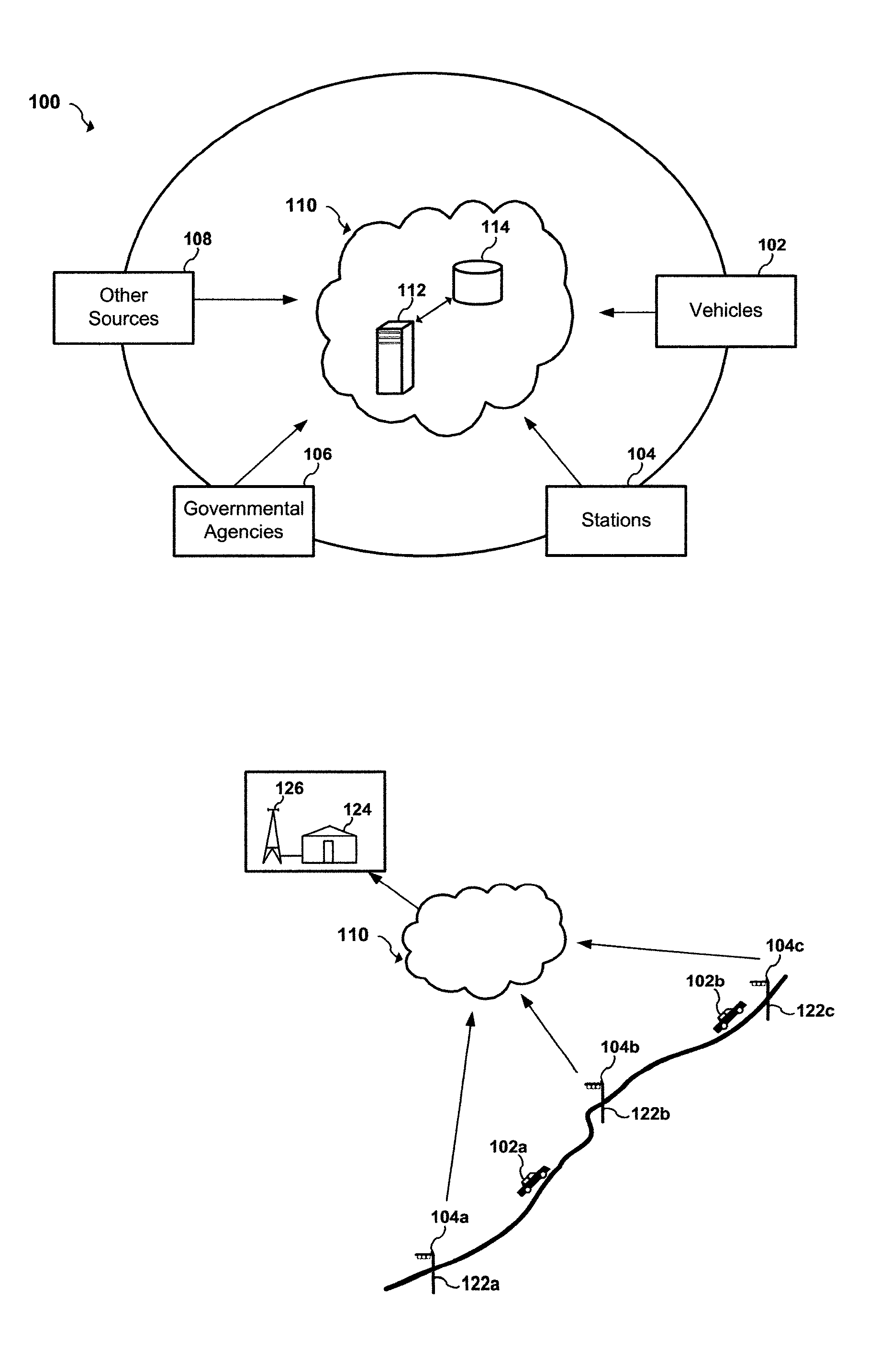
An apparatus and system to manage monitored traffic density in relationship to spatial locational flow rates. The system includes a variety of mobile and/or stationary transmitting and receiving comm-devices utilizing certified comm-devices equipped Avics iChipset arranged in a polarity of vehicles, in communication with stationary and/or mobile hub comm-devices and/or other certified comm-devices, strategically arranged within and/or along one or more roadways and in communication with a server channel networked to a central server. Configured to receive and/or transmit encrypted traffic data from the diversity of stationary and/or mobile transmitting and receiving comm-devices over the network, update traffic data in the non shared database, continuously calculate optimal traffic density flow for one or more of vehicles traveling along the one or more roadways based on the updated vehicular transit data, transmitting variations in speed adjustments in a network infrastructure to one or more vehicles; adjusting traffic light intersections based on traffic density traversing such roadways based on the optimal traffic flow suggestions combined with Predicated Traffic Artifacts transmitted via system generated encrypted digital comm-advice directives; and in turn share extracted and/or transmitted data with each state an federal DOT departments and other stack holders, including insurance companies and vehicle manufacturers and dealers with information to assist with making the traffic network safer. The present invention presents an Intuitive ITS engaged in Channeled Vehicular Telematics conveying statistical data, from an plurality of network devices, providing informational services forecasting safety-critical features and more, in return gathering and disseminating connected channelled intelligence between vehicles from within and surrounding infrastructures and other shareholders. Such data includes vehicle Phase-Change Spatial analytics from traffic congestion artifacts, along with Consumption Variable Analysis that provides real-time Energy Summation Data from combined vehicle exhausted energy by adjusting traffic flow based on traffic density in relationship with the human factor, vehicle capacity to navigate and topography and climatic variations in relationship with any area being traversed, and most importantly the use of the unique string identification. USIN acknowledged as `tMarker Audit Trail` or simply tMarker Trail as to data inception creation point. Managed within a secure private network infrastructure, each comm-device is synchronized with localized cloud servers in communication will a central server. This invention embarks on a new era in vehicle management, further enhancing time sensitive movements, leaving no doubt as to Vehicle Symmetry Orientation, especially once you move your vehicle and additional particulars currently not beyond the scope of this art presented herein. ITTS will throughly reduce the worlds fossil fuel supply consumption rate and on many other fronts availed by extracted data, transmitted from each vehicles onboard vehicle processor equipped with Avics iChipSet on certified comm-devices, reducing navigational concerns to elementary variables creating a safe traffic network.
| Inventors: | Taylor; Donald Warren; (Fredericksburg, TX) | ||||||||||
| Applicant: |
|
||||||||||
|---|---|---|---|---|---|---|---|---|---|---|---|
| Family ID: | 57601273 | ||||||||||
| Appl. No.: | 14/666588 | ||||||||||
| Filed: | March 24, 2015 |
| Current U.S. Class: | 340/905 |
| Current CPC Class: | G08G 1/096844 20130101; G08G 1/096775 20130101; G01C 21/3691 20130101; G08G 1/0965 20130101; G08G 1/096816 20130101; G01C 21/3697 20130101; G08G 1/096725 20130101; G01C 21/3415 20130101; H04Q 2209/47 20130101; G05D 1/0285 20130101; G06K 7/10475 20130101; G08G 1/0112 20130101; G08G 1/0116 20130101; G08G 1/0133 20130101; G08G 1/0968 20130101; G05D 1/0287 20130101; G08G 1/0141 20130101; G08G 1/08 20130101; G08G 1/096741 20130101; G08G 1/205 20130101; H04Q 9/00 20130101; G08G 1/0145 20130101 |
| International Class: | G08G 1/01 20060101 G08G001/01; G07C 5/00 20060101 G07C005/00 |
Claims
1. A method for the manageability of monitored vehicular aggregate traffic density, respectively, the `system` a computer-implemented method comprising: a localized cloud sync'd enterprise server hub network, connected to central server; wherein communication is securely connected with a network interface for each comm-device server is in communication with, receiving encapsulated encrypted data transmissions from one or more hub comm-device , each of which is a sub navigational system computing device receiving data from plurality of strategically positioned stationary and/or mobile communication hub comm-devices over a network of domain areas within a traffic infrastructure, each vectorhub class comm-device interface being configured to send and receive traffic data, wherein the traffic data includes vehicles phase-change spatial location and/or positional congestion artifacts and/or other intelligence necessary to preform real-time calculations; received from mobile comm-devices deployed in a variety of vehicles; and/or vector nodes strategically arranged along one or more roadways and/or in a virtual reality interface; and more general such stored particulars encompassed in an array of non shared encrypted databases in communication with the central server; wherein the central server configured to receive traffic data from the assortment of calculated strategically positioned remote stationary and/or mobile hub comm-devices over the network; creating a channeled telematics network from comm-devices equipped with Avics iChipset such as Obvipro, pAvics and/or other certified comm-devices; transmitting and/or receiving encrypted digital comm-advice directives to and/or from traffic vectorhub class comm-devices, in addition to updated traffic data in a non shared database; continuously calculate traffic density in proportion to rate flow for one or more of vehicles traveling along the one and/or more roadways based on the updated traffics dynamic data; and transmit timing adjustments over the network to one or more traffic light, quantum vector nodes and/or virtual nodes formulating XY coordinates in an overlay model, and from other certified vector comm-devices based on the optimal traffic flow calculations determined by speed variations in relationship to traffics density.
2. A computer-implemented method of claim 1, wherein comprising one and/or more of the plurality of remote stationary and/or mobile communication hubs and/or node comm-devices comprising computer-executable instructions that are hardcoded from within by a plurality of comm-devices each of which comprises an RFIDGPS transponder/receiver/transmitter iChipset, better known as Avics iChipset; structured as a hardware and/or a downloadable software
3. A computer-implemented method of claim 1, wherein comprising a non-transitory computer-readable medium whose stored contents may and/or may not be operated by a municipality, state and/or federal highway departments.
4. A computer-implemented method of claim 1, wherein comprising a non-transitory computer-readable medium whose stored data from channelized telematics, wherein comprises calculable updated traffic data from quantifiable traffic flow calibrated by traffic density augmented by human equation factors, and/or vehicular capacity to navigate and/or self navigate along with topography and climatic expectations.
5. A computer-implemented method of claim 1, wherein the central non-transitory computer-readable medium whose stored contents configure a computing device comprising a method is further configured to continuously updating traffic data in a database that may or may not be shared.
6. A computer-implemented method of claim 1, wherein further comprises a non-transitory computer-readable medium configured to execute computer-executable instructions from continuous updates, preforms calculations based on optimal density traffic rate flow from vehicular movements along the one or more roadways based on and/or from the updated traffic data that is either received or extracted from stationary and/or mobile comm-devices adjusting speed to maintain a constant variable traffic flow rates; and
7. A computer-implemented method of claim 1, wherein further comprising a fourth computer-implemented method that further comprises a non-transitory computer-readable medium configured internal computing device comprising encrypted transmissions from configured executable instructions for vehicular timing adjustments over a network infrastructure to one or more traffic light intersections based on the optimal traffic density flow rate calculations.
8. A computer-implemented method of claim 1, wherein further comprises a fifth non-transitory computer-readable medium configured internal computing device, to perform a method for providing data filtration from the received encrypted traffic data from one and/or more remote sync'd comm-devices performing computations in a non shared data base.
9. A computer-implemented method of claim 1, comprises a sixth non-Application transitory computer-readable medium configured internal computing device executing calculations from vehicular Proximitry Integration in respect to other surrounding objects in relationship to their phase-change spatial positions in roadways from vehicles based on transmitted and/or received data from side, rear, and front and/or from other certified similar comm-devices equipped with RFIDGPS transponder/receiver/transmitter iChipset that transmits and/or receives data to and/or from vehicles for avoidance of a collision.
10. A computer-implemented method of claim 1, wherein a seventh non-transitory computer-readable medium where stored contents configured by a computing device to perform a method comprising recommendations to adjust power intensity and/or turn off street lighting circuits and other open and closed circuits that may include traffic lights at any given intersection to switch to flashing yellow and/or another color and/or not flashing.
11. A computer-implemented method of claim 1, wherein comprises an eight non-transitory computer-readable medium where stored contents configured by a computing device to perform a method comprising regulating certified applications for security purposes that provide advertisements, directions, recommendations and/or other niceties from third party companies and the like, determining if there may exit malicious code within the data being transmitted to mobile and/or stationary comm-devices, if so alternative advertisements are pushed out. Such vendors are placed on review, until cause of code alternations are established. Vendors advertisements are screened periodically for code inspections, by random tests implemented for each vendor for security protection for the entire network infrastructure.
12. A computer-implemented method of claim 1, wherein the ninth non-transitory computer-readable medium where stored contents configured by a computing device performs a method comprising data filtering for content value and relevant requested advertisements and associated data sent from certified sources from third party venders for advertisements.
13. A computer-implemented method of claim 1, comprises a tenth non-transitory computer-readable storage medium configured computing device providing encrypted comparative historical vehicle data to one or more remote computer system over a secure network link with current and/or historical vehicular data to registered certified users and/or other computer systems and/or other certified shareholder; such data includes and not limited to active and/or not active Registered Sync'd and Paired and/or synchronize vehicles in any given network area infrastructure, such as information related to detecting complacency regarding CO2 and/or O2 output, vehicle maintenance issues, insurance, registration and inspection coverages from a non shared data base transferred to and/or from insurance companies and/or state and/or federal DOT and/or other stack holder data bases and the like, comparing data from each registered or not registered vehicle on any given network area, and further transmitting notifications to vehicles that are not in compliance and are in need of maintenance, tags, inspections and/or insurance coverage.
14. The computer-implemented method of claim 1, further comprises encrypted data wherein reporting and sharing of current and/or historical traffic data from and/or to municipalities, trucking and services vehicles owners, automotive dealers with relative maintenance information, current insurance records are compared with insurance companies, from transmitted data received from vehicular traffic that is either active on a domains network infrastructure or d-registered.
15. A computer-implemented method of claim 1, wherein comprises a virtual connection from each vehicle Registered Sync'd and Paired by way of a specific VIN# and/or assigned SHID# and/or other established credential means that identifies each transport mechanism within any given network traffic infrastructure area that is collectively currently linked up and/or identified within a traffic system area network infrastructure.
16. A computer-implemented method of claim 1, wherein that comprises each comm-device equipped with Avics iChipSet that registers on a domains network infrastructure goes through authenticated sequence before activation, the process entails a sync-d pairing event using hard-coded encrypted paired-key sets, each device it loaded and/or injected with these paired-key sets, either upon installation and/or at time of creation and central server has the matched sets assigned to a particular comm-device that is archived.
17. The computer-implemented method of claim 1, wherein comprising verifications of traffic packet congestion artifacts within any given network infrastructure, determined by sending out a continuous patterned transponder echo calls to verify that any Obvipro, pAvics or other certified comm-devices that has Registered Sync'd and Paired and authenticated or in anticipation of registration and/or is online and/or offline within any given vehicular traffic network domains infrastructure.
18. A computer-implemented method of claim 1, wherein comprising a deployment detection process for vehicle Registered Sync'd and Paired pAvics and smart comm-devices or the like equipped with RFIDGPS transponder/receiver/transmitter iChipset that transmits and/or receives data that references and/or compares such data from non-transitory computer-readable storage medium device as to current tags, insurance and inspection status; such comm-devices are either on the windshield, on dash and/or from smart comm-devices; from entered data uploaded via web based and/or virtual interface and/or from within a smart comm-devices downloadable application either by voice and/or manually entered, such registered data is linked to a smart comm-device for older vehicles that have reduced OBD capabilities or under dash mount tied to OBD output equipment with first generation OBD2 in conjunction with on board vehicle processor.
19. A computer-apparatus structure of claim 1, wherein comprises vehicles equipped with Obvipro equipped with Avics iChipSet and/or other similar certified comm-device capable of installing portable versions of pAvics, wherein stored contents comprising a configured computing hardware and/or software device performs data transmissions once downloaded and installed from a secure link, and/or integrated with current vehicles processor, that is Registered Sync'd and Paired with a traffic network infrastructure; driver data is sent and/or received and compared with a non-shared data base and/or entered manually, and driver verifications by iVoiceCommands and/or viewed via vehicles display screen and/or heard audibly on vehicles speaker system as to validity of data inputted.
20. A computer-apparatus structure comprising of claim 1, wherein the name pAvics and/or similar comm-device comprises a configured computing coded program that preforms a Registered Sync'd and Paired sequence with system once downloaded and installed from a secure link in any certified smart comm-device, communications start once authenticated within domains infrastructure.
21. A computer-implemented method of claim 1, wherein comprising a non-transitory computer-readable medium with one or more processors to execute computer-executable instructions stored in a memory within a configured internal computing device executing mathematical computations, computing traffic flow dynamics from the field of cross-layer optimization, artificial intelligence and/or machine learning.
22. A computer-implemented method of claim 1, wherein comprising each datas transmissions as they pass through any type of comm-device and/or other electrical-mechanical device generates a unique string identification name known as USID. acknowledged as `tMarker Audit Trail` or simply tMarker Trail. displaying both the tMarker and t2Marker that unconditionally displays a VarIChk Index as to the datas creation inception point whereabouts which comm-device data was created. and further providing a list of each device it passed through and/or was used by to manipulate. used for processing. analytical purposes or to store data.
23. A computer-implemented method of claim 1, wherein comprising a non-transitory computer-readable medium with one or more processors continuously calculating computations producing authoritative traffic speed variations from comm-advice directives that coincide and/or simulate vehicular rate flow density spacing, allowing safe phase-change spatial repositioning of vehicles in the event of lane changes.
24. A computer-implemented method of claim 1, wherein the non-transitory computer-readable medium further comprising one and or more processors configured to execute a computer device configured to create a viewable Digital Virtual Telematic Architecture interface, also known as vTelarc structured from GPSGIS Esri Positioning Overlay Model, utilizing data from certificated comm-devices equipped with Accelerometers and or a Quantum Accelerometer and or Quantum Compass that produce precise locational traffic artifacts where visual coded components adhere to non-modifiable code standardization and commonality generating a 2D, 3D and/or 4D interactive interface viewed on Obvipro's screen and or on other similar certified comm-devices.
25. A computer-implemented method comprising a virtual interface such as vTelarc, that represents vector nodes with virtual representation of traffic lights, warning signs, advertisements and/or any traffic signage currently in use and projected to be used to control vehicular traffic and/or warn traffic of pending items such as without limitations as to current weather telematics, speed recommendation, distance variations between each vehicle and more are virtually assimilated into Obvipro's notification display screen or other similar certified comm-devices.
26. A computer-implemented method of claim 1, wherein comprises a computer device configured to calculate phase-change variations, broadcast Vehicle Symmetry Orientation process that exchanges vehicle Phase-Change spatial positional data and/or other information from surrounding vehicles, enhancing time sensitive movements or positional variations in the eventually of an accidental occurrence due to lane drifting intentional and from other un-anticipated movements from surrounding vehicles, each occurrence is documented with vehicles defined locational phase-change spatial position in relationship to others that were or may have been collided with, and transmitting avoidance comm-advice directives to surrounding vehicles for maneuvering vehicles positional relationship outside danger zone with those vehicles involved in a potential occurrence; some and/or all data exchanges maybe a certified PSE (paid service event).
27. A computer-implemented method comprising of claim 1, wherein vehicles currently equipped with proximitry integration sensors, the data from sensors are shared throughout system domain network area to surrounding vehicles, sending notifications to all calculable effected vehicles, further adjusting speed variations throughout localized areas, with comm-advice directives to brake, change lanes, move off road to side and other notably configured comm-advice directives to avoid collision.
27. A computer-implemented method of claim 1, wherein a non-transitory computer-readable medium configured internal computing device comprising computational memory functions using Phase-Change Artifacts for precise spatial location for any vehicles Long/Lat co-ordinate traversing along any roadway with surrounding vehicles.
28. A computer-implemented method of claim 1, wherein a non-transitory computer-readable medium configured internal computing device comprises computed locational positions with configurable determination if vehicle is in a safe location for disablement, sending requested notifications to specific vehicular comm-devices for disabling on board vehicle processors from driver/owners providing Driver Assist Remote Lock Down for stolen vehicles and Driver Assist Disablement--better known as DAD as a certified PSE (paid service event) enhancing parental vehicle management.
30. A computer-implemented method of claim 1, wherein comparative data is analyzed with vehicles registration, process variables such as VIN# ID, vehicle size and other historical vehicle data from manufactured and/or design information for each vehicle used to de-activate vehicle capacity to move and is in a stationary position at time of disablement and/or notify municipal authorities in the event of vehicle theft or is out of compliance as to lack of registered access with any infrastructure.
31. A computer-implemented method of claim 1, comprising a non-transitory computer-readable medium further comprises a computer device configured to, providing advanced protected routes for Emergency Vehicles such as Fire, Ambulance, Safety Officers and/or dignitaries from suggestive variable routes and/or with time factored enhancements from dynamic analytical lane allocations through entire route, and further notification are sent to vehicles along the route with alternate routes and warning to pull over.
32. A computer-implemented method of claim 1, wherein comprises a non-transitory computer-readable medium further comprises a computer device configured to scan for deviations within and around any domain network infrastructure, utilizing SentryBeacons and/or SentryHubs and/or other similar certified comm-devices; detecting foreign matter and/or anomalies to intercept hacks and/or perpetrators masking data that is not originated from Autovecth--Command Offices, communicating through Avics iChipsets to certified comm-devices detecting improper traffic notifications from data attacks and/o other maliciousness engaging Triangulation Sentry Fortification.
33. A computer-implemented method of claim 1, wherein comprising SentryHubs that act as dual tVectorHubs or others similar comm-devices, and are stand along Hubs and/or Nodes in any given area within a domains infrastructure; more specifically those used in the following areas: school zones, construction zones and further deployed in other areas that show traffic speed, lane closers or re-routes through construction zones or any where necessary to protect network infrastructure safety.
34. A computer-implemented procedure of claim 1, wherein comprising a non-transitory computer-readable medium further comprises a computer device configured to provide continuous digitally enhanced localized updated Channelized Telematic Weather feeds from NOAA, ECMWF and other countries weather predicting agencies; perhaps deployed through local academic facilities. These weather feeds may be a PSE--(paid service event).
35. A computer-implemented method of claim 1, wherein comprising a non-transitory computer-readable medium and further comprises a computer device configured to calculate positional artifacts from multiple XY co-ordinates (Long/Lat) laced together with spatial third dimension Z--Topography and Climatic Expectations; comparing the spatial phase-change artifacts mathematically mapping positional differences; allowing distance variables between vehicles that coincide with anticipated breaking calculations for speed variations, computing probabilities on margin of error for each vehicles variable braking capacity based on age of vehicle in proportional relationship as to equipment type and age of brakes, weight and other corresponding vehicular factors; and further inject calculated variables into formulated equations that commix human response variations from historical data as to future expected positional points and/or relationship with other surrounding vehicles.
36. A computer-implemented method of claim 1, wherein traffic packet congestion artifacts within any given domains network are determined by sending out the transponder echo call to verify that any Obvipro, pAvics or other certified comm-device and/or such as vectorhub class and/or node comm-devices that has either registered and paired or anticipates registration or is online and/or offline within any vehicular traffic domains networks infrastructure.
37. A computer-implemented method of claim 1, wherein comprising a communication commencement protocol, in respect each comm-device is assigned a unique SHID ID #, upon being energized within networks infrastructure, a registration docking process entails the use of verifying each comm-devices SHID ID# with a Paired-Key authentication process before comm-device becomes Load Networked to communicate within a domains network infrastructure.
38. A computer-implemented method of claim 1, wherein echo calls are sent to every vehicle that arrives at destination or is off network; if there is no reply from echo request calls from tVector Hubs and/or other certified comm-devices in the area for any given Obvipro's, pAvics and/or other similar certified comm-devices last known location, system calculates a comparison to the whereabouts of its location now in relationship to where it is at present. Upon reentry on any given domains network area infrastructure, historical data is compared and verified for possible theft and/or maliciousness if data does not match.
39. A computer-implemented method of claim 1, wherein iVoiceCommands are either initiated by system encrypted comm-advice directives and/or imputed by driver as to turn signals, braking and other vehicular maneuvers, in turn system will provide advance notification features given with and/or without iVoiceCommands and/or just visual displays on a virtual interface of these commands with notifications to surrounding vehicles modifying spatial distances and/or other maneuvers, from system and/or driver stimulated engagements; for turns, lane changes without notifications or turn signals manually activated from within vehicle and/or in auto command mode, braking and the like; encrypted digital traffic comm-advice directive notifications of vehicle positional changes are sent to surrounding vehicle with current encrypted data push techniques viewed on a virtual interface and/or audibly heard and/or viewed from other similar certified comm-device screens.
40. A computer-implemented method of claim 1, wherein a downloadable link is established to provide the installation software used in pAvics, Obvipro and/or other certified comm-devices.
41. A computer-implemented method of claim 1, wherein portable Avics iChipset integrates with current locational services in smart comm-devices equipped with accelerometers and/or quantum compass.
42. A computer-implemented method of claim 1, wherein SentinelHub are deployed in school zones not only to verify speed violations, and capture those vehicles that speed during school zone time frames, along with placement in other traffic areas where speeding is a known problem or other areas of concern.
43. A computer-implemented method of claim 1, wherein SentinelHub(s) and/or SentryBeaconHubs and/or other certified comm-devices within this class initialize TSF techniques using Reflective Backscatter Technologies tracing specific infrastructure vector nodes and/or other comm-devices for intrusion origination points.
44. A computer-implemented method of claim 1, wherein SentryHubs are deployed inside school and/or other public transportation busses initially during the first phase of deployment and/or may not be removed after final deployment phase once onboard vehicle processors are equipped with Avics iChipSet, detecting vehicle equipped with pAvics that pass stopped busses, or a combination of pAvics and/or SentryBeaconHubs can be used, that can calculate vehicle speeds, route alternations fuel savings; perhaps as a PSE locational service for parents and/or other entities, and a shared sync'd database with local authorities.
45. A computer-implemented method of claim 1, comprising SentryBeaconHubs, SentryHubs and the like are combinational comm-devices such as tVectorHubs equipped with Avics RFIDGPS transponder/receiver/transmitter iChipset, that use TSF (Triangulation Sentry Fortification) monitoring anomalies within network area infrastructure.
46. A computer-implemented method of claim 1, comprising each Avics iChipsets deployed within certain VectorHub Class become inactive for what ever reason, a pre-configured defined programmed code within this specific class of comm-devices, have the internal capabilities to be energized remotely initiating Long/Lat Range (LLR)WIFI comm-devices, using GPS and/or GPS/GIS or other current technologies and/or with satellite verifications for each vehicles locational position and transmitting same; until such time erred comm-devices are repaired and re-energized. Then these LLR comm-devices are shut down remotely by system generated procedure.
47. A computer-implemented method of claim 1, comprising vehicular traffic managed by Administering Organizational Control responding with a Cloud Based Sync'd Enterprise Architecture.
48. A computer-implemented method of claim 1, comprising driver sensitivity attentiveness variables as to driver attentiveness are archived, these variations are then monitored and cataloged for each driver in relationship to other drivers, advancing predictable calculations formulated by the need in braking capacity, use of blinkers and other vehicular movements, wherein calculations from traffic variable comm-advice directives are sent to each Obvipro, pAvics or other certified comm-devices in advance as needed or requested by driver and/or automatically from autonomous vehicles.
49. A computer-implemented method of claim 1, wherein comprising iVoiceCommands sent by means of digital encrypted traffic comm-advice directives to Obvipro and/or other certified comm-devices and/or audibly viewed virtually on display screen using GPS/GIS imaging, comm-advice directives display in a virtual reality interface in realtime as driving and able to be chosen in variety of international languages.
50. A computer-implemented method of claim 1, wherein comprises locational navigational services that may include GPSGIS displayed on vTelArc's toggled virtual interface, incorporating a split and/or not viewable screen when turning on service generated for iNavX2 that are in connection with providing multiple comparative serves from NavStar and/or GPS.gov and/or ATT Navigator and/or from other similar providers.
51. A computer-implemented method of claim 1, wherein comprising a network procedural protocol protection procedure that each and every vector hub class and/or node and/or similar certified comm-devices and system servers communicate by encrypted transmissions, whether transmitting and/or receiving data and/or transponders signals.
52. A computer-implemented method of claim 1, wherein all street lights, along with all street signage currently deployed and/or in anticipation of being used, are enabled in a virtually model, and located using handheld GPS and/or GPSGIS locational comm-devices, such as Trimble and/or similar devices, collecting each signage in use or imputing same as to each signage's specific long/lat that is embedded into a vTelarc GPS/GIS model creating each as a Virtual tArcObject.
53. A computer-implemented method of claim 1, comprising each hub device such as: nodes, Obvipro, pAvics and other certified comm-devices has a unique SHID (Stationary Hub Identifier) assigned too each and hard-coded on circuitry built into device.
54. A computer-implemented method of claim 1, wherein each municipality may have assigned their own dedicated IPv(set) for security reasons.
55. A computer-implemented method of claim 1, wherein each tVectorHub, VectorHub Class comm-devices, vector nodes, Obvipro, pAvics and other certified comm-devices equipped with Avics RFIDGPS transponder/receiver/transmitter iChipset comprising either hardware and/or software integrated circuitry, wherein each internal transponder and/or receiver and/or transmitter comm-device, is effectively a separate device independent of each other processing pre-configured communications between each; receiving external data, securely transmitting data to one or more internal and/or external devices, communicates through a secure encrypted datalink, tunnel or similar separate secure communication link between each, some of which preforms pre-configured computations, marks data as data enters and/or leaves, then transmits data securely through encrypted protocols between each comm-linked device that may or may not act separately of each other in pre-defined tasks.
56. A computer-implemented method of claim 1, wherein calculations that determine traffic speeds within a specific network area requires continuous traffic data feeds from traffic artifacts based on flow rate in conjunction with calculation frequency determine by the relationship with traffic flow, combined with the human factor and vehicles capacity to navigate, along with driver historical data in proportion to the density factor of traffic in any given network sector in a particular infrastructure.
57. A computer-implemented method of claim 1, wherein each stationary hub and/or node comm-devices such as Obvipo's or smart devices installed with pAvics and other certified comm-devices communicate between each other and the system, comprises a PairedKey Datasets and along with an hardcoded SHID that such Paired SHID Key both use crypsis tokenization.
58. A computer-implemented method of claim 1, wherein the comm-device termed Obvipro, pAvics and other certified comm-devices are equipped with Avics iChipset.
Description
CROSS REFERENCE TO RELATED APPLICATIONS
[0001] The present application is a continuation-in-part of and claims priority to U.S. patent application Ser. No. 13/815,807, entitled "Apparatus and System for Monitoring and Managing Traffic Flow" filed in the U.S. Patent and Trademark Office on Mar. 15, 2013, now U.S. Pat. No. 9,070,290. U.S. patent application Ser. No. 14/158,797 entitled "Apparatus and System for Monitoring and Managing Traffic Flow" filed in the U.S. Patent and Trademark Office on Jan. 18, 2014, wherein each application is a continuation of and claims the benefits of priority under 35 U.S.C. .sctn.120 and having at least one common inventor as the present document and each of which is incorporated by reference in their entirety.
BACKGROUND OF THE INVENTION
[0002] Field of the Invention
[0003] The present invention is generally related to vehicular transportation, and more particularly to a structured apparatus and system to manage monitored traffic flow based on Phase-Change density factors, sharing contemporary and historical data with certified share holders, and both state and the federal DOT.
[0004] Discussion of the Background
[0005] Intuitive Intelligent Traffic Systems commands real-time data signals encapsulated, some of which by way of encrypted mobile and/or static comm-devices, collecting physical events indicating positional Phase-Change spatial locations for each vehicle in relationship to other vehicular movements within any given network domains infrastructure. Thereby providing stern evidence that pushes Quantum Mathematical Boundaries displacing momentum and positional points calculated at the same time from multiple XY co-ordinates (Long/Lat) laced together with spatial third dimension Z--Topography and Climatic Expectations commixed with the human factor, vehicle capabilities to navigate amalgamated within the network architectonics that intensifying traffic throughput by way of a Channeled Telematic Architecture. CTA is created by incorporating sub-navigational systems that only communicate with specific comm-devices, this feature establishes a security proficiency by establishing a secure protocol for comm-device sync-d and registered with other comm-devices having a direct data transmission com-link with the systems servers.
[0006] With ever increasing degree of road traffic congestion and the related road rage in certain areas, there are specific variables to manage monitored traffic density safely. In doing so relaxes congestion and aids in alleviating unexpected maneuvers from careless drivers, supports redundancy of communication links to many different types of comm-devices. Resulting in fuel consumption decreases in direct relationship, association with environmental concerns such as CO2 and other engine maintenance items are maintained constant, including management of items such as vehicle inspections, licensing status and insurance coverages become relative to the overall equation.
[0007] Thus, flow variations of network traffic manageability decreases useless idle times, and more requiring earnest attention regarding fuel consumed to break and/or minimize inertia, the second true element in this traffic ecosystem modeled equation and the most important is manageability of variable sustained vehicle velocity. By allowing vehicular traffic to flow in variable speed variations within the state of this inventions created ecosystem drives measurable analytics, evaluating the temporal effectiveness on how well traffic systems performance can be further enhanced in reducing speed between lights, allowing cross traffic to seamlessly flow along with other secondary roadways, traffic becomes manageable exponentially.
[0008] Existing systems lack an efficient stable and most importantly a uniform structured operating system, and generally depends on direct line of sight, with visual observations of some sorts produced from devices like infrared receivers, cameras that have limited visual detection zones and other devices used to aid emergency and other vehicular traffic that are not reactive enough if at all and most require a direct line of sight to function somewhat properly. Video image vehicle detection system (VIVDS) that need to be humanly monitored and are inconsistent with detections due to having an engineer manually draw and/or automatically adjust the limited detection zones repetitively too identify precise areas of concern due to vehicular traffic positions and/or size variations within the lanes themselves.
[0009] Furthermore, loop detectors that are fairly expensive and results in area concrete deterioration from water infiltrating that causes cracks, and have a high failure rate with limited capabilities along with other expensive devices that do not collect real-time data from multiple positional reference points continuously throughout any municipality and/or on freeways. Such techniques can only provide extremely limited short range manageability with little or no proficiency, if any at all for the manageability of multiple vehicles and are too imprecise for more sophisticated management strategies that engages the ability to monitor traffic density and there associated variables such as maintaining safety-critical distant factors between vehicles based on density flow rates as speeds increases in direct relationship.
[0010] Thus the aggregate density of traffic has a direct relationship to area traffic speed within cities and or freeways. Whereby the increased distant between vehicular movements creates less dense traffic resulting in a safer network, since this distant factor assists in lane changes, unexpected or system generated speed reductions maintaining a safe velocity rate flow in any given network infrastructure. Managing variable density flow rates provides the decreases energy consumption and provides vehicular maintenance warnings, realtime insurance coverage verifications capabilities along with current inspection and/or valid license status and other data, and are generally not automated nor shared with governmental or other entities that are part of the current vehicular traffic equation.
[0011] Current traffic equipment and/or studies do not take into consideration as to the staggering amount of fuel needed to obtain momentum again after stopping, beside idling and these statistical studies lack evidence as to many types of vehicles old, new and not properly tuned. Thus, there currently exists deficiencies in managing flow rates in relationship to traffic density and the further need of a uniform standardization, comprising architectural application reliability so that no matter what country or state you drive in, the system encompasses a uniform traffic architecture also known as UCA.
[0012] Phase-Change Spatial Analytics helps municipalities make advanced informed decisions regarding vehicular density and the need to map some traffic to other routes in advance to maintain maximum destination variations consist with original routes destination time frames, and/or make spatial phase changes in velocity to other cross-layer intersections. The data collection assuredly sheds new light on road concentration costs, short and long term future congestion alternative.
[0013] In conjunction with vTelarc Phase-Change, spatial analytical data modeling from overlay map-objects provides decision makers from city to state DOT telematics business intelligence, including traffic modeling for public transportation and school busses, along with significant monetary saving in all area of current traffic management.
[0014] The invention provides business owners such as trucking and/or service related enterprises a Smarter Processing Platform enabling proven financial performance from their assets. The power to plan maintenance and/or new roads, visualize, share across multiple platforms, and to create safer vehicular infrastructure. As with our past, Phase-Change Spatial Analytics is a body of methods and techniques formulated for analyzing spatial scalability, the results of which depend upon the spatial density arrangement from prior moments in vehicular artifacts past and/or present movement. These analytics provide informatics far beyond the tool set for querying, measuring, transforming, describing, optimization from conceptual testing from the real-time data harvested.
[0015] Furthermore, the need for standardized International Transit Telematics System, also known as ITTS is consistent for the advancement in traffic telematics world-wide, that continually computes traffics phase-change spatial positions virtually throughout any given network infrastructure area. Maintaining standardization in distance factors based on density on freeways or for that matter any traversed roadway with transit variables compiled with in-exhaustible speed variations, detections of lane deviations from Vector Lane Drift, also known as vLaneDrift notifications integrating Proximitry Integration.
[0016] Further advancing Traffic Congestion Artifacts in relationship to other vehicles from planned and/or not route destinations, as it relates to alternatives for planned or unplanned routes, detours and other traffic variables codifies traffic flow based on a regulated flow rate in relationship with the aggregate density composed with the human equation, vehicle capacity to navigate, along with topography and climatic factors that keep to a minimum unnecessary idling and/or minimizing the need to consistently break inertia.
[0017] Signal light control mechanisms, cameras and the like are minute representations in the whole scheme in traffic control that does not account for the time/distant equation for the entire network traffic infrastructure in any given municipality or the surrounding conurbations approaching interactions, and for that matter even on freeways in an around and between any town or metroplex. These are a few examples of just another one of many priority elements this system, Administers Organizational Control responding with a Cloud Sync'd Enterprise Architecture in secure communication with a central server.
[0018] Currently there are statistical records that provides most cities have very large numbers of non-compliant vehicles without current tags or for that matter inspections and/or that are not properly insured. Previous statistics show nearly 40 percent of all drivers in the Dallas--Fort Worth MetroPlex do not carry insurance, and further possibly more due to lapsed coverages at any given time period. Insurance coverages can be updated/paid through the `system` network using secure ECDLinks creating many more tech jobs.
[0019] The preferred understanding of the system embodiments, comprises an architectural resemblance of, opening up and looking inside either a PC and/or a Mac. Both have a pre-configured and most assuredly that of which constructs is merely an infrastructure, that has made its way to this inventions over all composure and to its processes managed by knowledge from the infrastructure itself at all communication levels encompassing Channeled Telematics.
[0020] The resources municipalities have currently in use, once moved over to a manageability role, utilizing current deployed traffic devices as the need to be replaced arises and/or move over too, as in taking down certain intersections traffic lights and other signage. The savings from bidding new contracts for equipment that is not sufficient to adapt much further without significant costs, maintenance heavy, along with updates on internal hard and or software are substantial.
[0021] Taking the cost of one four-way double lane intersection from traffic lights w/hardware and cameras, and/or other sensors, the dollar amount moves close to 5 figures in some instances much more. By placing one or more tVectorHub comm-devices and/or other combinations of other types of hub devices for any particular intersection going away from the intersection for a mile or more or less and/or replace all forms of signage and their associated poles and towers with exceptions of course. The cost to convert over to a completely digital infrastructure is extremely cost effectively accomplished, with less effort, with more flexibility and endless possibilities to advance traffic flow to an art such as the computer industry has done. The jobs to manufacture comm-devices, to deploy same, to manage the infrastructure both local, state and federal jobs with independent contractor jobs at all levels and to maintain, analysis the informatics and share with other tribal entities from data the system generates both in-house and in the field creates a new era in telematics. Most of these jobs are somewhat technical in nature and other positions require degrees in specific fields, again to manage, oversee and improve the system.
[0022] Objective reality of this structured apparatus and converging subsystems is to protect drivers and lessen the cost in vehicle management, substantial reduction in combined vehicle exhausted energy and creating a platform that will universally accommodate the paradigm shift in Managed Autonomous Usage-based Insurance.
[0023] Fundamentally, MAUBI sets a standard for composure in traffic infrastructure reliability that enhances detection, uses rudimentary comm directives for each manually, semi-autonomous and/or autonomous vehicles once linkup to assist in the ability towards predictive drive ability creating an Intuitive Transit Telematics System. While accurately pricing faulty drivers by non-engagement, insurance carriers hold risk in check, realized from generated Statistical Telematic Analytical Data--STAD.
[0024] The need for managed Cloud Based Sync'd Architectural system is necessary since data driven comm-devices produce astronomical amount of information, and the need for such data to be extracted into one area server will not suffice, even under the best of conditions.
[0025] Traffic flow rate has a direct relationship with traffic density cloaked with human emotions, the vehicles drive-ability and/or its capacity to navigate autonomously, along with climate and/or topography conditions and other expectations. Taking emotions out of the equation as much as possible, with expectational standardization, managing the density factor; network traffic can be reduced to a elementary manageable framework by adjusting speed in proportion too density or in some events vis-a-vis, thus managed flow rates become rudimentary.
[0026] Moreover, safety-critical functions that navigate by universal encrypted digital comm-advice directives minimizes wasted fuel, and of course with permission as to advice directives that inform each driver as to their spatial relationship with other vehicles utilizing Density Point Clustering Schema--DPCS, and in turn predictable automation as to expectable driver destination that was either chosen on the fly or programmed into network status and/or archived for daily routes takes place autonomously. Measuring and recording the amount of vehicular traffic proximitry density at any given time frame (moment) relative to a specific point, compared with the speed of the comparative clustered mass area chosen, common variations in predictable conception provide results to manage vehicular flow rates at future points in time.
[0027] Furthermore, non-insured vehicles and/or non-compliant vehicles place a substantial burden on the cost of insurance and our environment over all for each citizen from within any country. After Phase1 is brought into effective action notably, insurable costs are reduced by safer road conditions, and these concerns fade during the first phase of deployment from detection of a Registered Sync'd and Paired pAvics with a downloadable certified application for smart devices or other certified comm-devices with similar communication capabilities. At first encouraging driver engagement to manually enter vehicle data via secure web-link or entered the data from within the downloadable applications secure link for requested informational data linked to drivers VIN# such as current tag number, insurance and inspection status, age, any physical limitations, use of glasses and more by way of a non shared data base; this self entered data is verified from a shared and/or other databases with local or state authorities and/or shared with insurance companies updated informatics as it becomes available.
SUMMARY OF THE INVENTION
[0028] The present invention relates to an apparatus and structured system to manage monitored physical rates of change from vehicular locational movements in relationship to traffic density derived from traffic congestion artifacts, the human elements and navigational capacity of vehicles, along with Topography and Climatic Expectations. Creating a channeled telematics infrastructure, by sharing phase-change spatial situational awareness informatics in real-time from vehicular movements. With RFIDGPS integration merged with operational map-objects co-ordinated with a virtual graphical GPSGIS interface, also called vTelarc (Virtual Telematic Architecture) that utilizes multiple services for navigational informatics from NavStar and/or GPS.gov and/or ATT Navigator and/or from other similar providers in conjunction with weather forecasting sent through iVoiceCommands and/or on a virtual screen from a toggle interfaced that turns on navigational service generated from iNavCom facilities displayed on iNavX2 interface. Providing the ability for each comm-advice equipped with Avics iChipSet to communicate H2V, V2H, V21, 12V and/or V2V and sharing harvested data with state and/or federal DOT, along with insurance carriers and other certified shareholders. The system includes (i) a plurality of mobile transmittable and/or receiving and/or transponder capabilities comm-devices and/or other certified comm-devices such as without limitation equipped with Autovecth iChipSet (RFIDGPS), also referred to "AVICS" devices, such geographic positional data and/or rendering from one or more vehicles may utilize devices equipped with accelerometers and/or a quantum compass, installed with pAvics during PhaseI deployment for vehicles not equipped with ODBII technologies, arranged from within a variety of vehicles and/or attached to any motorized or not vehicular transport device such as with an individual person and/or on bicycles in which each device is equipped with Avics iChipset a downloadable application installed using existing equipments locational service that transfer corresponding phase-change spatial long/lat coordinates and other pre-defined data continuously from within the smart comm-devices installed application and further receives speed recommendations, trip analytics based on computational comm-advice directives, certified advertisements and/or other similar traffic data.
[0029] For vehicles equipped with ODBII technologies, the assimilation of Obvipro incorporates a similar downloadable application installed either before installation and/or after being registered synchronized with system before download starts. Such as without limitations using Avics iChipset that receives, transmits and used transponders to verify not only data but also integrity of comm-device from traffic data such as; dimensional mapping locational services displayed on a virtual interface, vehicle disablement that transfer corresponding spatial long/lat coordinates before a safety-critical disablement, and pre-defined data continuously generated from accelerometers and/or a quantum compass, transmitting back to vehicles speed variations depending on density, lane adjustments based on dynamic analytical lane allocation for trucks, dignitaries and such with destination variations and more recommendations based on computational traffic data from; (ii) a plurality of stationary and/or mobile autonomous comm-device placed within safety officer vehicles and/or connected hubs, nodes and other certified comm-devices strategically arranged along one or more roadways and in communication with, (iii) cloud based central servers comprising a Cloud Based Sync'd Enterprise Architectural Infrastructure securely communicating with , (iv) network interfaced with a localized central server in communication with, (v) various sub navigational system databases with VPC (Virtual Private Connection) and/or a secure communication data link with each central server configured to, (vi) receive and/or transmit encrypted traffic data and/or digital advice directives from the plurality of mobile and/or stationary transmitting and receiving comm-devices over networks infrastructure, (vii) update traffic data in the non shared database, (viii) compare certain data in a shared data base against transmitted archived data, and filtration of certain data, (ix) continuously calculate optimum traffic density from one or more of vehicles traveling along the one or more roadways in connection with variable speeds based on computational traffic congestion artifacts, and (x) transmit encrypted timing adjustments over the network via encapsulated digital encrypted voice and/or virtual commands to one or more traffic lights or traffic tVectorhubs for any given intersection, and/or other certified comm-devices such as Obvipro and/or within vehicles traversing along any roadways and/or thoroughfares based on the optimal traffic flow dynamic calculations, (xi) transmitting and/or receiving via secure encapsulated speed comm-advice directives and other adjustments and notifications through hubs and node comm-devices and/or by virtual means directed to specific and/or all vehicles through vTelArc within any specific and/or all domains network infrastructure, (xii) each network interface is configured to respond to a specific identification number that is sent, received from traffic data, wherein some of the traffic data includes vehicle location, Phase-Change Artifacts and/or other informational data associated vehicles ID# conveyed from a plurality of VectorHubs and/or virtual VectorNodes, (xiii) then sent to corresponding Obvipro's, pAvics and other certified comm-devices relevant to the calculated datas specific and/or requested data calculated and, (ivx) continuously repeats extracted data calculations, entire process without interruptions adjusts for density vs. speed variations and other pre-defined computational variables as the need arises such as for warnings, lane adjustment and all other associated items mentioned herein. (xv) Entire system is configured as a Virtual Private Infrastructure, communicating only with certified link-sync-d comm-devices, of which these devices are equipped with the Avics iChipSet.
[0030] Further processing calculations are preformed in direct relationship with traffic speed in conjunction with density composed with flow verses density, combined with the human elements--that is to say drivers age and their responsiveness to react, attentiveness to listening to audible and/or visual commands and other human factors such as age, time of day, etc.; vehicles capacity to navigate, topography and climatic data, along with historical driver data regarding previous programmed trips like to work and/or random excursions and such for personal, service and/or commercial and for both interstate and/or intrastate commerce vehicles previous routes and driver behavior indexes.
[0031] The slower the traffic speed, fewer calculations are necessary; or in another way the slower the traffic is, in relationship with the density of traffic, frequency calculations intervals are longer. Again flow rate is corresponding, since time/distance variations are proportional to calculable advice directives being sent to selective comm-hubs in isolated sectors within a particular domains infrastructure for specific vehicles. Otherwise, computational authoritative comm-advice directives will not coincide with vehicular flow rate from lag time in computations that are irrelative to the current time data was received by Obvipro and/or pAvics iChipset and/or other certified comm-devices. Thus randomized computational analysis is inefficient; since the speed of calculations must simulate the speed of any given domains traffic infrastructure area calculated, and is one of the core components of intuitive traffic systems.
[0032] Further each municipalities infrastructure has domains within the entire infrastructure, these domains are determined and/or managed based on historical traffic density within each domains area. Further some domains are residential domains, others are shopping center domains, and so forth to be determined by the appropriate governing body, and/or other areas that may require additional cameras and/or other comm-devices within specific domain infrastructures for additional security measures. Infrastructures outside any municipalities jurisdiction, these domains infrastructures are managed by counties, since they too are currently managed by and/or governed by same the sheriffs office and/or county commissioners in partnerships with state entities. Once vTelarc is enterprise ready, the expectational expenses related to maintain traffic signage throughout each counties infrastructure reduces exponentially thereafter, possibly shifting to other expenditures that is more boots or cars on the ground so to speak.
[0033] Another aspect of the present invention is to provide a method for a electronic apparatus program embodied on a electronic comm-device processing received and/or sent data for managing monitored traffic density rate flow in a non shared database. More generally this apparatus and system includes (i) a first non-transitory computer-readable medium further comprising a computer device configured for receiving and/or transmitting and/or responding to transponder calls, extract data formulated by continuous variable frequencies of encrypted traffic data from a array of stationary and/or mobile comm-devices and/or vector node comm-devices and/or virtually, strategically arranged in a managed protocol along one or more roadways and in communication with a plurality of mobile comm-devices, some of which are Obvipro's, pAvics and/or other certified comm-devices, arranged from within a plurality of vehicles over a networks infrastructure, and/or attached to humans or non motorized such as bicycles and the like, (ii) a second non-transitory computer-readable medium further comprising a computer device configured for updating encrypted traffic flow density rate data in a non shared database, (iii) a third non-transitory computer-readable medium further comprising a computer device configured to receive continuous variable frequency data feeds from mobile comm-devices calculating optimal traffic density congestion rate flow from one or more vehicles traveling along the one or more roadways based on the calculable updated traffic data, and, (iv) a fourth computer code comprising computational data for transmitting timing adjustments over the network to one or more traffic light intersections and vehicles equipped with certified comm-devices based on the optimal traffic flow calculations, and (v) a fifth non-transitory computer-readable medium further comprises a computer device configured to preforms a method that filters certified third party applications such as advertisements and the like for security risks, (vi) a sixth computer-apparatus structured code comprising computational memory functions using Phase-Change Artifacts for exact spatial location for each vehicle, by projecting multiple mathematical equations creating optimizes overlay models, resulting in faster indications for system generated encrypted variables, creating a Super-Accurate Navigational System, and (vii) a seventh computer apparatus encrypted repository system comprising a shared database with state, country or federal department of transportation authorities, and (viii) a eighth non-transitory computer-readable medium further comprises a computer device configured to preform a process comprising BeaconHubs, SentryBeaconHubs and SentryHubs that may or may not be combined in part with other Vector Hubs or stand along comm-devices and the like scanning the area network for intrusions, hacks or other maliciousness that disrupts systems attitude and, (ix) a ninth non-transitory computer-readable medium further comprises a computer device configured to preform a process comprising an operational system creating a Digital vTelarc GPSGIS Overlay Model calculated form data transmissions creating a Quantum Positioning Overlay Model using accelerometers found is smart devices and/or a quantum compass, in a networked wifi infrastructure for secure communications. Using a standardized code, in that the displayed code is generated with current XHTML, HTML5, XML, XSLT or current none modifiable display code that utilizes cross-platform-compatible codes requiring no plugins. Simultaneously producing traffic vector nodes on a virtual display screen that provides images for warning signs, traffic lights, digitally encrypted speed variations either by audible and/or virtual means for curves in road ahead and all other signage being used currently, that is effectively inputed showing exact spatial locational position for other vehicles in a translucent back ground with drivers vehicle enhanced visually, with system overtures as to implicit details for on demand localized maps of area roads being traversed; virtually displaying buildings and the like with 2D, 3D and/or 4 dimensional toggled aspects for all surroundings and, (x) a tenth non-transitory computer-readable medium further comprises a computer device configured to preform a process comprising a plurality of transmitting and receiving comm-hubs and/or nodes, know as SentryBeacons or SentryHubs detecting foreign matter to intercept hacks or data attacks engaging Triangulation Sentry Fortification--also known as TSF, utilizing current techniques for Reflective Backscatter Technologies and, (xi) a eleventh non-transitory computer-readable medium further comprises a computer device configured to preform a processes that incorporates longitudinal an latitude vector nodes as to each traffic light, and all other current and future deployed traffic signage as to there specific geographical location that overlays the basic framework for GPSGIS Virtual Telematic Architecture, also known as vTelarc in a 2D and/or 3D and/or 4D each with Overlay Model perhaps from Quantum Positioning, formulated by accelerometers and/or a quantum compass in smart comm-devices and/or by current real-time virtual modeling means.
BRIEF DESCRIPTION OF THE DRAWINGS
[0034] A more complete appreciation of the present invention and many of the knowledgeable advantages thereof will be readily obtained as the same becomes better understood by reference to the following detailed description when considered in conjunction with the accompanying drawings, wherein:
[0035] FIGS. 1A-1D are block diagrams illustrating a system for managing and monitoring traffic density flow in accordance with an embodiment of the present invention; and
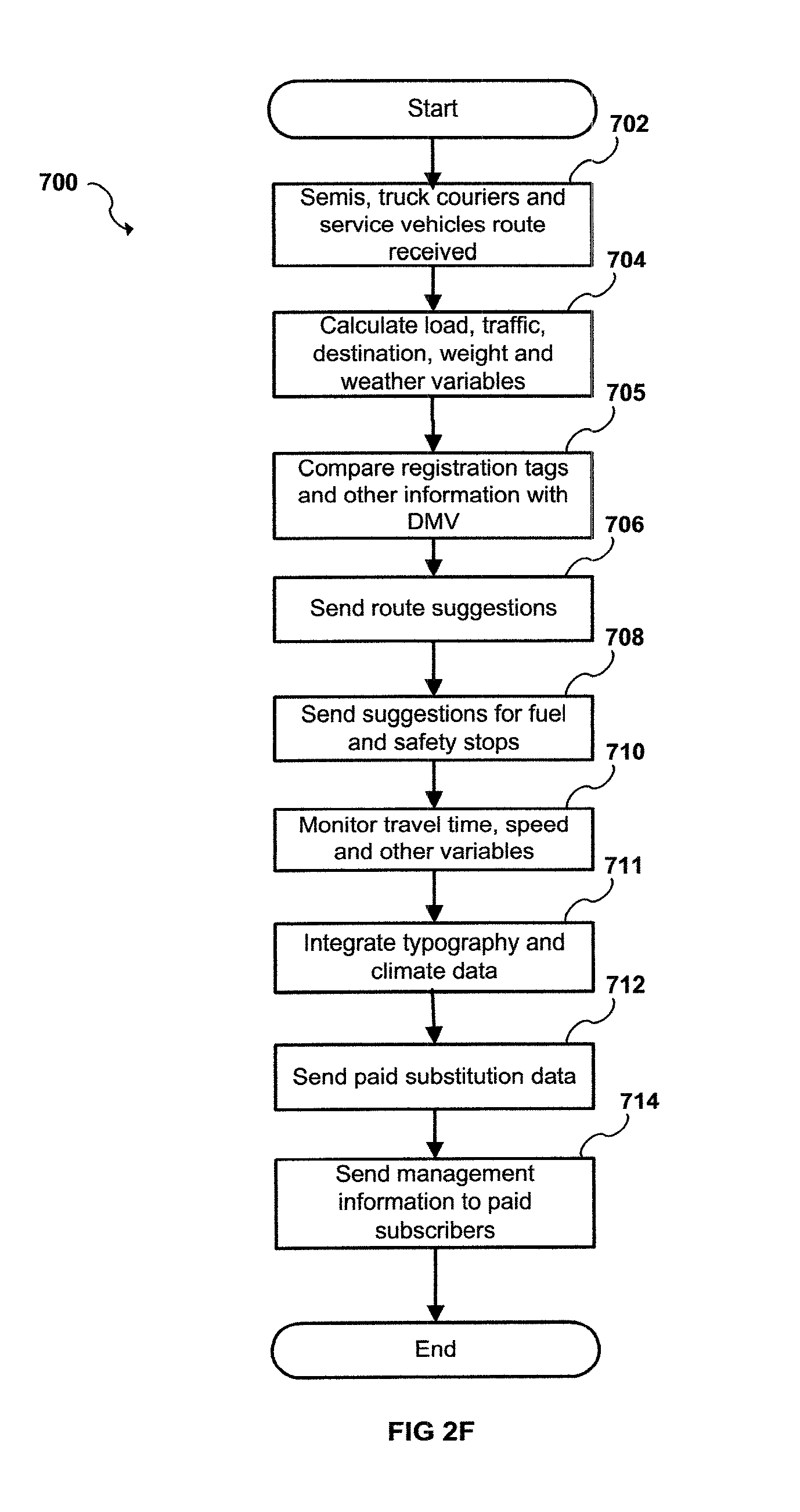
[0036] FIGS. 2A-2F are flow charts illustrating a method for the managing and monitoring of traffic dynamics in accordance with embodiments of the present invention.
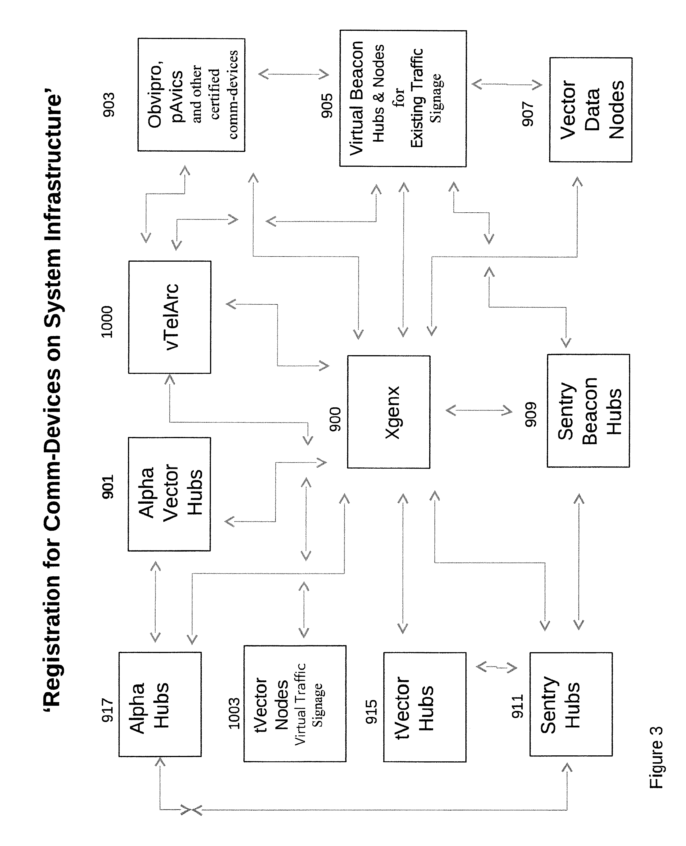
[0037] FIG. 3 is a flow chart illustrating the method described in the inventions embodiments for registering vehicles of any type on system's network domain infrastructure, enabling secure manageability of monitored vehicular traffic flow and density in accordance with embodiments of the present invention.
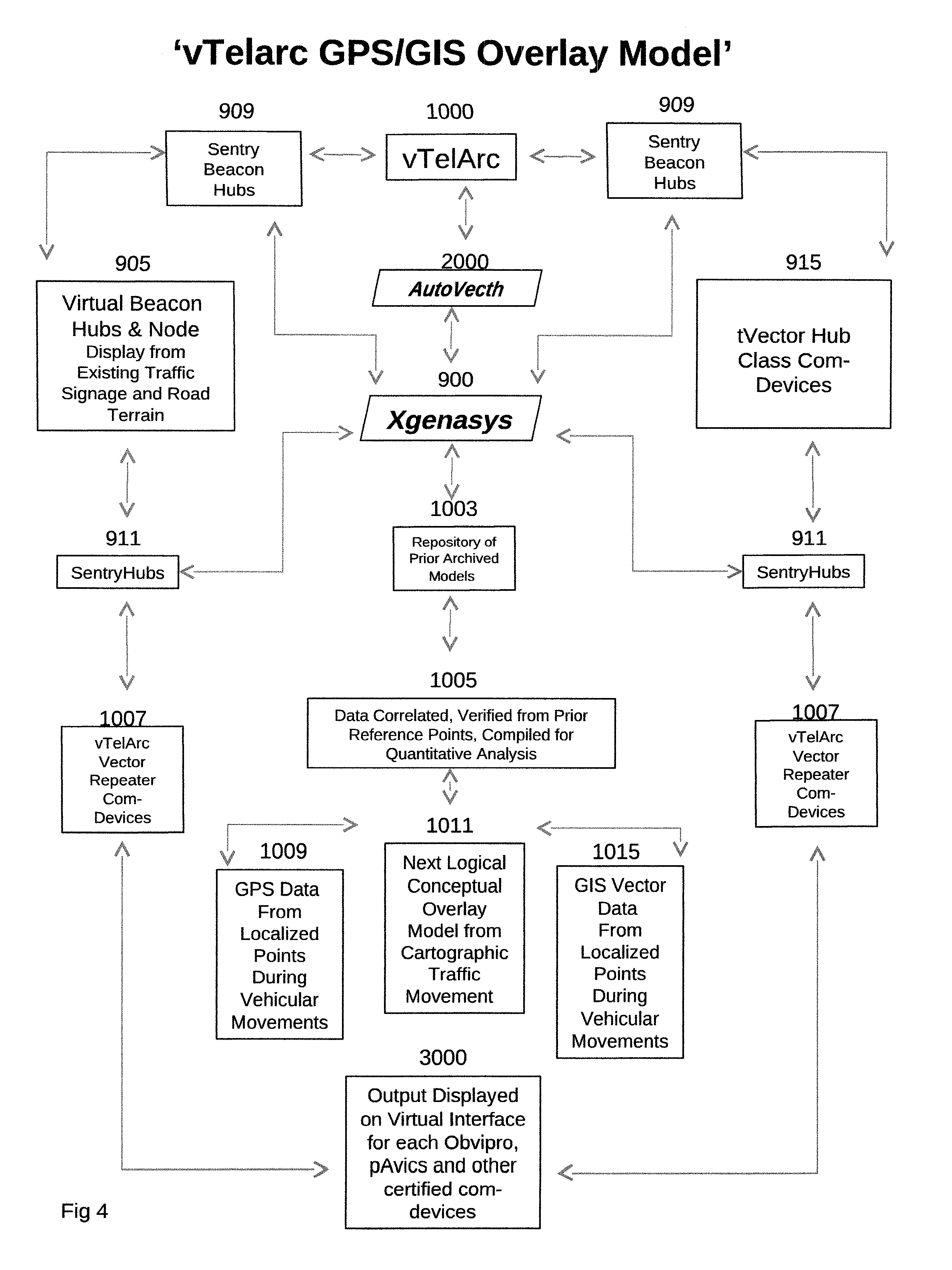
[0038] FIG. 4 represents the Virtual Telematic GPS/GIS Overlay Model configuration process.
DETAILED DESCRIPTION THE PREFERRED EMBODIMENTS
[0039] Referring now to the drawings, wherein like reference numerals designate identical or corresponding parts throughout the several views, preferred embodiments of the present invention are described.
[0040] The present invention relates to an apparatus and system that manages monitored vehicular traffic flow in a network infrastructure in an area served by one and/or more static comm-devices conveying Phase-Change positional movements and other data from one or more vehicles equipped with Avics iChipSet providing real-time vehicular forecasting .
[0041] According to one embodiment, the geographic positional data from one and/or more vehicles may comprise such as without limitation a certified comm-devices having the Autovecth iChipSet RFIDGPS transponder/receiver/transmitter, also referred to "AVICS". Herein after iChipset refers to `Identified Chipset`, meaning each chipset within each comm-device has a unique SHID assigned and hardcoded NOS that is non-changeable and/or modifiable. According to other embodiments, the geographic positional data received from commercially available consumer comm-devices equipped with accelerometers and/or a quantum compass and/or satellites and/or from archived data from other sources from GPSGIS data and/or same from third parties and/or the like; overlaid into a virtual interface using non-modifiable codes, displayed by means of such as without limitations on mobile phones, smart comm-devices, PDAs and/or other such certified comm-devices equipped with Avics internally and/or downloaded and installed pAvics software.
[0042] Such current geographic positional data may include information received without limitation from satellites from different sources depending on services required and/or needed in certain areas and/or costs. The geographic positional data may be in the form of a geographical position, such as longitude and latitude, also known as longlat, or may be other current except able forms which can be converted into such a form. The information collected on the progress of the individual vehicles can be used to dynamically calculate the combined average speeds, transit times and proportional Phase-Change spatial locational density factors of each vehicles movement in relationship with other vehicles and more. The information collected also includes calculable recommended traffic congestion options for alternate routes, emergency and/or dignitary vehicle travel variables and dedicated lane isolation for commercial trucking and/or school busses and similar transit vehicles.
[0043] The data received from each vehicle's processor includes but is not limited to fuel consumption data, maintenance information, mechanical information from onboard vehicle processors, CO2 and or O2 consumption variable output, emergency information calls, web-interface for deactivation of vehicle along with trace routes for stolen vehicles and disablement of same and the like. As used herein, the term "OBVIPRO" refers to an onboard vehicle processor, and it is also understood that Obvipro maybe a downloadable software application preforming similar features and/or functionality as with a hardware installation, further known as pAvics.
[0044] According to one possible implementation, vehicle Energy Summation Data is transmitted from onboard vehicle unit--Obvipro, for Consumption Variable Analysis for historical tracking purposes of fuel. ITTS will throughly reduce the worlds Fossil Fuel Supply Consumption Rate and on many other fronts availed by extracted data transmitted from each vehicles Obvipro (onboard vehicle processor) & pAvics (portable Avics) and other certified comm-devices. Using the over all network traffics consumption analysis from CO2 and O2 exhaust and/or other informatics that provides real-time reduction in Energy Summation Data from combined vehicle exhausted energy by adjusting optimum traffic flow in conjunction with density variables, including but not limited to street lighting circuits, or any other open and or closed electrical mechanical device and or other commercial conveyances an more; system embarks on a new era in intuitive vehicle management.
[0045] Receiving stations include one and/or more transmitting and/or receivers and or a transponder in each, known as VectorHub Class comm-devices, strategically placed along various roadways, park, and walk-way locations, and the like. As used herein, roadway locations include, without limitation, municipal traffic lights at any intersection, intersections using stop signs, lighting circuits, camera feeds from fixed or stationary local highways parks, walking trails, secondary roads, freeways and interstate roads, rest stops, bridges, landmarks, municipal buildings, selected freeway mile markers and other common areas, such as sub-divisions parks and such.
[0046] According to the present invention, existing wired and/or wireless networks, wide area networks, ad-hoc networks, and systems may be modified for continuous data feeds from one and/or more comm-devices woven into a dynamic computational algorithmic architecture (DCAA). According to one possible embodiment, communication is received from one or more communication comm-devices, sometimes referred to as "tVector Hubs" or "hubs", strategically placed at traffic intersections, roadway locations and/or other locations. The network may optionally be enhanced to handle the network data necessary to manage the traffic flow in real time, make suggestive analytical calculations to advance hands free driving. Such data includes data received from, and/or to, the one and/or more stationary and/or mobile transmitting and receiving comm-devises, received and/or transmissions from comm-devices within vehicles. Traffic flow management includes automatically presenting alternate routes, granular decelerate/accelerated speeds recommendations, accident updates, planned road maintenance along with growth projections, alternative routes due to congested routes or intersections, roadway light failures, and the like.
[0047] Traffic flow management adjustments may be directed towards specific traffic lights at one or more traffic intersections to adjust the general traffic flow maintaining variable velocity formulated based on traffic density from one intersection to another. Traffic flow management may also be directed towards specific vehicles to suggest alternate routes, and granular decelerate/accelerated speeds recommendations based on density within any given area, calculations are derived from the human elements, the vehicles capacity to navigate, especially whether vehicle is older and/or maneuvering autonomously or semi-autonomous. Each digital transmitted comm-advice directives are formulated from computed variables associated with each particular vehicles cataloged informatics, turn signal notifications--driver and/or system initiated depending on what deployment phase system is in. Onboard `Object Functionality Points` (sensors on sides, rear, front of vehicle). Proximitry Integration detection, will allow Reactive Response Interval Feeds into onboard systems, advising each drivers vehicle spatial relationship with surrounding vehicular traffic in the event of vehicle migration and other mishaps either audibly or on a virtual interface.
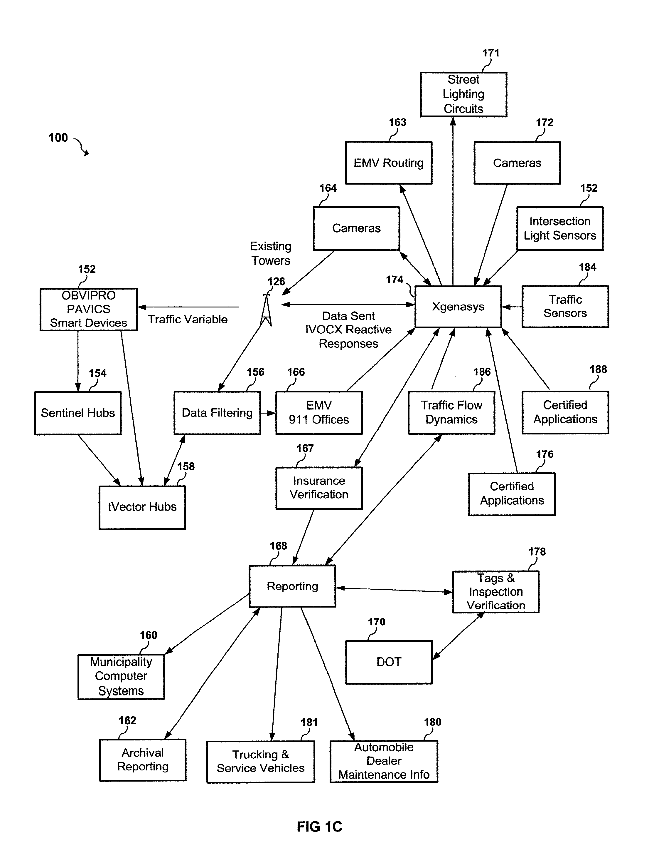
[0048] In accordance with further enhanced implementation, the use of a variety of hub comm-devices intensify the over all awareness of vehicular traffic flow, density and safety by using specific Hubs which are as follows: VectorHub Class comm-devices some are BeaconHubs, SentryBeaconHubs, SentryHubs, SentinelHubs, Sentry Nodes, AlphaHubs, AlphaVectorHubs; b, c, d and xVectorHubs; each sub hub has an explicit task, the duty of which is specifically allocated for any given sector within networks infrastructure area.
[0049] According to one enhanced implementation, AlphaVectorHub communication links filter certified broadcasts that may or may not be encrypted advertisements, whether its for gas, lodging or shopping and the like. Each area VectorHub have sub-classes of which only a designated advertisement is broadcasted, such as without limitations determining a specific vehicles energy summation data, based on Consumption Variable Analysis that a certain vehicle may need fuel, and providing logistical computational data as to the next available fuel supply points or better known as fuel nodes that are displayed with alternatives regarding fuel manufacturer types and other niceties. Other AlphHubs for advertisements are added within this realm for food nodes in the virtual interface, lodging if a calculable variable is computed for rest time or driver selected based on fatigue attributes; completely maintaining autonomy as to each sub-class in a particular industry managed by sub navigational systems, thereby protecting and enhancing digital traffic broadcasted comm-device directives.
[0050] According to one possible enhanced embodiment, each city or municipality may have their own AlphaVectorHub sub-class, wherein locational services such as fuel, food, lodging and the advertising of such are a PSE generating revenue for that particular city, creating income thereby offsetting expenses in maintaining local system infrastructure. Operational management maybe bid on based on specific governesses so enacted, soliciting bid proposals for such opportunities.
[0051] According to one possible implementation, the IEEE 802.11 protocol may be utilized for communication with palmtop computers, laptop computers, personal digital assistants (PDAs) and Internet mobile phones and/or other certified comm-devices. The 802.11 standard specifies two modes of operation: (i) an infrastructure mode where an access point provides the link between wireless stations and wireline legacy infrastructure, and (ii) an ad-hoc mode where there is no access point. By using tVector Hubs to collect real time data that is feed into a central processing complex of cloud based sync-d servers, each tVector Hub contributes to the telematic distributed management and control of the entire network. (iii) Wherein the use of Plug-n-Play activations are used to expedite preregistration synchronize for comm-devices in any given network infrastructure area wherein vehicle is traversing and/or moving into an adjacent and/or new infrastructure. With additional data being sent on to the next infrastructure in the vehicles route destination.
[0052] According to an advanced implementation, comprising the operating system maybe built on a Unix platform. According to this non-limiting implementation, verifications of tVector Hubs occur routinely in sequential random patterns. Secure notifications are sent out to each tVector Hub class device for authentication purposes, to verify integrity of each unit using a cryptic VPI connection. The network may utilize Crypsis Tokenization, otherwise known as encrypted tokenization. Each tVector Hub is routinely verified by a data push, which is encrypted, for original data composition. On deployment the token is placed within each tVector Hub's core operating system. If the tVector Hub is deprived of power, is hit with a power surge, or has otherwise been compromised, then the tVector Hub data maybe rolled back and/or a secondary internal board or a processing code may be energized (or if necessary, the Avics iChipset can be replaced quickly).
[0053] If any Avics iChipsets deployed become inactive for what ever reason, certain deployed Avics comm-devices within there specific class have internal capabilities to be energized remotely initiating Long/Lat Range WIFI transponder/receivers and/or using GPS satellite verifications; until such time erred comm-device is repaired and re-actived.
[0054] According to one embodiment, test tokens are sent to verify operational areas for data integrity composition inspections. If any of the tVector Hubs NOS are not the same as its original encrypted token, the tVector Hub data is rolled back. Off-line for maintenance and operating system updates, hardware failures/software updates may be propagated throughout random comm-devices for a specific domain area within the infrastructure, with redundant cloud-based server capacity to maintain operational up-time. The data from tVector Hubs may be sent via one or more token sets for security protocols originally implanted.
[0055] These data composition inspections have pre-defined examination protocols for specific comm-devices; determination of maliciousness from code injections and the like for any comm-device. If such err exists the next dataset values are examined, if datas encapsulated encrypted key is intact, transmitted data is used for calculations; authenticated component composition of previous digital advice directives are compared for locational anomalies. If err exists, the next positional locational dataset transmission is comparatively overlaid for compositional comparative analysis for datas integrity. Finally data optimization parameters are excited against topography and climatic conditions, human elements, vehicle and drivers ability to navigate with other referenced data, comparative parameters are verified against last data set transmission, if data clears--meaning current data has to pass several pre-configured tests based on previous datasets once clear, data is parsed for computational events, then repeated for next transmission.
[0056] One of the benefits of RFIDGPS transponder/receiver/transmitter iChipset is the ability to track multiple mobile and/or stationary comm-devices such as onboard vehicle processors establishing long/lat isolation integration, such as without limitation, OBVIPRO, pAvics, cameras with stationary or fixed feeds, street lights and other smart comm-devices simultaneously within any given networks framework, such as without limitation a city, a township, a railway, highway, freeway, river or the like. Intermixing of network packet traffic variables, having a reserved IPv(set), along with subsets for each municipality which increases security and localizes any threat attempt. Allowing tracking attempts much easier within any particular networks framework further encapsulating transmitting a radio frequency identifier variations from/to any type of vehicle, smart devise or the like. The system relies on several tVector and/or data node points for redundancy.
[0057] Utilizing a (Stationary Hub Identifier) SHID that has a dedicated IPv(set), that reflects the ESN and/or other unique cellular identifier assigned to each Avics iChipset within each VectorHub, OBVIPRO and/or pAvics, signal integration interactions allow data message transmissions from/to each whether independent and/or networked with many VectorHubs, OBVIPRO, pAvics and other certified comm-devices securely. Forming a wired/wireless ad hoc framework is essentially expedited with the direct communication from/to each comm-device that has a unique RFIDGPS transponder/receiver/transmitter iChipset--integrated circuitry identifier encapsulated within using integrated cellular capabilities for enhanced distances, and for redundancy. Each municipality can deploy that communication process that is most readily available to maintain cost implementation in the beginning, with migration over to the most current com-links at a later date.
[0058] Communication is transmitted from/to each tVector Hub, that receives and/or transmits data from/to each vehicle's Obvipro, pAvics and/or other certified compliant comm-devices, compiling simple data that creates complex fuel consumption variables, engine analysis, long-lat spatial positional points in relation to other vehicles and speed variations of each, from vehicular traffic that passes through, around, above and/or below these hubs comm-devices. Data collection is transmitted with multiple com-links (e.g., wireless, electric lines, Wi-Fi and/or gigabit wide/local area networks and/or by other currently known technologies such as electrical lines and/or different mobile communication networks, such as without limitations UMTS, WLAN, and WiMAX and/or CTP and not limited but in support of advanced communication networks that can be extended to support other advanced IP networks, such as long term evolution (LTE) to each command office.
[0059] By analyzing the dynamic analytical rate flow (DARF) in comparison to dynamic analytical lane allocations available, along with dynamic directional flow constraints calculated inputs from network traffic congestion artifacts are faster an accurate. The process, computational traffic flow dynamics draws principles from the fields of cross-layer optimization, artificial intelligence, machine learning creating a dynamic computational algorithmic architecture from dynamically compiled data transmitted to and/or received from each comm-device on any local and/or wide area network that is sync-d linked together from each hub and/or node and every on board processor and/or other similar comm-devices equipment with Avics, that comes into range of any mechanical and/or electrical-mechanical and/or software receiving/transmitting hub comm-device and/or similar certified comm-device deployed within an infrastructure.
[0060] Network packet artifacts are determined by sending out a transponder echo call to make sure that any OBVIPRO and/or other certified comm-devices that have Registered Sync'd and Paired on the network, has arrived at destination and/or is off network. If there is no reply from echo request calls from tVector Hubs in the vicinity of any given Obvipro's, pAvics and/or other types of certified mobile and/or static comm-devices last known location, `System` calculates a comparison to the whereabouts of its location now in relationship to where it at present after reply from vehicles response to echo call before vehicle is turned off
[0061] According to one embodiment comprising a communication commencement protocol for comm-devices registration on any network areas infrastructure consists of each tVectorHub and all other VectorHub Class comm-devices and/or vector nodes and/or virtual nodes and/or receptors have built in RFIDGPS transponder/receiver/transmitter--also known as: Avics iChipset, all data sent and/or received is encrypted. The transponder in each hub and/or node comm-device transmits and receives a unique SHID that corresponds to not only its long/lat Phase-Change spatial position as with mobile comm-devices, it also transmits the unique SHID ID# assigned to stationary comm-device. Each of these various class of comm-devices are assigned sets of unique encrypted paired keys that were originally hard coded when deployed and/or injected in field. Once comm-device is deployed and upon being energized on a given networks infrastructure, sends a responder SHID key to system, the system responds with the encrypted Paired-Key acknowledging comm-device on the domains network infrastructure.
[0062] The secondary half of the encrypted Paired-Key is sent back from `system` to any certified comm-device that initiated access, only after the dual verification is completed transmission will proceed. Each key is encrypted and transmits via a VPI (Virtual Private Infrastructure) tunnel to one or more comm-devices and/or along other secure means mentioned herein, and/or all comm-devices can be load-networked within a given domain area when the infrastructure transmissions are linked to each other.
[0063] Other comm-devices may only use wifi and/or both may use electrical lines and/or by other current means that are convenient, inexpensive and secure. The second transmitted response Paired-Key that is embedded within the first Paired-Key when energized, then acknowledged by the sending hub, node, system server and/or other certified comm-devices whether virtual or not, to any comm-device within the load-Networked' domain area and/or within specific domains infrastructure, with this second encrypted key that was hard coded and non modifiable. Once each new comm-device is energized within a domains infrastructure, followed by the registration authentication Sync'd and pairing sequences, the procedural events form a Load- Network, wherein all comm-devices such hubs, any comm-devices equipped with Avics iChipsets and/or other similar comm-devices only communicate with those devices that they were paired with, including any servers. Malicious and/or unknown communications are ignored, attempts are logged and sent to SentryBeaconHubs, then further pushed onto localized cloud servers, then onto central server. Such data is cataloged, followed with research as to ISP provider and/or remote rouge attacks from a single stationary device, information sent to authorities, requesting user informatics of these known IP attacks, with possible fines and more.
[0064] Responses are generated vis-a-vis from either system to hub, and/or hub to system and/or Obvipro to hub and/or vis-a-vis, and so on for any comm-device that initialized by the first comm-device that requested acknowledged on the network, and using the appropriate Paired-Key for response to an invite and/or vis-a-vis. There are other matched Paired-Keys and these too are also encrypted for redundancy an security purposes and some of which are layered for a third level and/or more sequential authentications for secure measures to certain class comm-devices, such as creating a path for emergency vehicles and/or dignitaries and the like; and there may be additional paired transmitted and received keys for each comm-device, enclosed within an encrypted rapper, and further comm-devices only respond with a specific reversed layered binary mathematically encrypted matched Paired-Key initialized hand-shack internally for another layer of security.
[0065] All Paired-Keys sets are archived in an encapsulated encrypted repository, that routinely requests verifications from each comm-device for their associated Paired-Key and each device it loaded and/or injected with have the matched set for each paired-key set. The central servers have the entire key sets, and continuously monitor comm-devices data transmissions key sets for structured integrity. Key injections done in the field, the keys themselves are encapsulated and encrypted and registered for a specifically designated comm-device solely registered to positional assignment. Field technicians do not have the ability to make alterations, since the keys themselves are assigned to a specific comm-devices SHID ID# only, that it already been confirmed by central server as to its long/lat position.
[0066] Within each hub, node and/or other certified comm-device virtual and/or not there is a small program code that can be ran remotely and/or internally for system generated integrity verifications as to keys both paired and the responding key. This small code runs independent of the OS, and configured to run within and/or outside the NOS's core hardcoded area, preforming analysis verifying encrypted Paired-Key sets, determining alterations from malicious or related items from a hard coded blue print of the comm-devices integrity upon deployment when paired with other registered comm-devices.
[0067] If anomalies found comm-device sends a encrypted distress signal through SentryHubs unto `system` requesting maintenance, shut down, roll-back and/or request verification to activate OS memory flush and/or inject the hardcoded NOS back into OS. Each deployed comm-device has unique layered Paired-Key sequence to activate the flush procedure. Functionality of any device may and/or may not continue based on parameters defined for specific events. System runs enterprise quintessential data integrity checks randomly, the same process is initiated for other comm-devices that have been flushed and/or updated OS before system energization, to verify comm-devices relationship to and/or with other comm-devices for articulated data before re-activation. Thus there are protocols for any comm-device to be energized, and follow-up procedures in place to be activated with the infrastructure before and/or during communications.
[0068] Further each hub, node, and/or other certified comm-device equipped with Avics iChipSet has a separate transmitter to send data passed from a hardware and/or software integrated circuitry comprising separate receivers and/or a separate transponder and/or transmitters that has a unique SHID ID# assigned and/or hardcoded. Further noteworthy is once a specific Obvipro transmission is received by a certain vectorhub, the hubs receiver activates the ecep to mark the data just entered comm-device, then the hubs transmitter activates the ecep upon datas exiting hub onto another hub class comm-device and/or onto sync-d cloud server and then onto central server. These comm-devices are tied/linked together, and may consist of hardware and/or software integrated circuitry, and are independent of each other in preforming tasks for security reasons. Each of these comm-devices the transponder, the receivers and the transmitters goes through a similar Paired-Key process internally allowing verification and screening for malware injections, non certified transmission of attempted code implants and/or maliciousness and/or other such rouge anomalies. Each Obvipro, pAvics and other certified comm-devices equipped with Avics iChipSets have a similar internal process as with the hub, node other certified comm-devices that constantly verify data transmissions, digitally encrypted traffic comm-advice directives from computational derivatives, via iVoiceCommands and/or for viewing in a virtual interface empowered by transparent informational knowledge, building a channelized infrastructure that holds firm to the advancement of Cybrintelligence, where human knowledge is merged with machine languages.
[0069] Each class of comm-devices utilizes a combination of these processes and/or depending on data held for suspension, formulated by a second evaluation of the next transmission and/or received datasets. Furthermore, each Obvipro, pAvics installed on smart comm-devices uses a similar pre-defined procedural verification several times throughout devices linkup status.
[0070] Once a offline vehicle re-activates registration, archived data is then comparatively analyzed so as to create a baseline interpreter mark of last transmission received, so that any new registered activations from any certified comm-devices integrity composition are reverified. Once Obvipro and/or pAvics and/or other certified comm-devices complete initialization within a domains infrastructure is verified, a determined route alternative is excited from previous offline positional node location, system begins communication. These end of life trip events are archived for future use and/or deleted from users interface based on drivers needs. However this data is not totally deleted, its archived for future activation and/or for analytical purposes and compared against other vehicle and future trips by same vehicle.
[0071] Each vehicle, whether a truck - any size from a half ton to a semi truck, car and/or other motorized medium that transports goods, services and/or people; when registration on a networks domain infrastructure occurs by Syncing that particular VIN# and/or other unique identifier is paired with all associated information such as weight, dimensional size, manufacturer and/or all data associated with a particular vehicle, along current insurance, inspections and/or licensing data and/or other informatics archived--meaning comparative data that has been matched to either a specific route, vehicles driver interactiveness in conjunction with surrounding vehicles informatics and the like is connected to their vehicles specific VIN# and/or uniquely assigned ID and/or other informatics complied from previous registrations within any given networks infrastructure and/or in comparison to age of vehicle and/or the driver attentiveness and all other factors associated with responsiveness and there associated human factors and/or other derived data that benefits additional safety items. Finally, the paring event is completed once acknowledged, vehicles Phase-Change spatial relationship is computed as it maneuvers throughout the network, compiling data, computing traffic variations and sending information as requested by driver and/or system recommendations for diving advice directives, entertainment and navigational suggestions as requested by driver and/or autonomously from vehicles Obvipro's informational recommendations based onboard vehicles processors current integrated capabilities with Proximitry Integration.
[0072] Phase-Change positional point calculations are determined by the anticipated time-lag in respect to distance data sent has traveled in proportion to vehicular rate, formulated adjustments with the next digital comm-advice directives transmission is comparatively analyzed with the previous calculable dataset sent. In other words, calculations are pre-configured based on vehicular rate flows relationship to timestamp of data received for phase-change positional points, and further adhere to similar calculations for datasets being sent out and finally accommodating all other aspect ergo human factors, vehicle/driver capabilities and surrounding weather and the like, prior to next datasets transmission sent to vehicle. Thereby, if any unexpected migration and/or other occurrences toward another vehicle occurs, calculations from specific artifacts are recorded as to which transport entity unequivocally initiated a particular disturbance and/or a lane drift that took place whether from human error and or equipment failures of any type e.g. mechanical aspects of vehicle, non-engagement and/or attentiveness of driver and/or internal hard/software and/or failures from combinations thereof. iMarkers are notated, formulating sensitivity factors calculated for future incidents, such as vehicle heading in wrong direction and/or instantly sending out notifications to effected traffic and/or surrounding vehicles, either by audible iVoiceCommands, and/or to the virtual interface vTelArc with procedural steps for all anticipated vehicular traffic that may be affected from such occurrence with evasive actions to be taken by driver and/or autonomously by each vehicle, as to those that are stolen and/or headed in wrong directions--system can safely pull vehicle over and/or shut down the operating system in vehicle and/or notify surrounding authorities in such an occurrence.
[0073] According to an embodiment comprising a formula for secure data transmissions, each of us live in a state, within the United States. So shall `system` starting with the municipalities, townships, counties and the like from where data originally gave rise to and harvested from its creation inception point. Thus, as stated throughout this invention displayed, data should be collected from is origination point, compiled with protocols that generates the path from whence the data came from. Consider, since traffic data generation began from within and between cities, so shall these areas have clear dominion over such data as to gathering, performing calculations therefrom for a multitude of reasons, archiving, and to disseminate the datas results whence originated from. Example: To be an open intelligent system, regarding the dissemination as to the generation of such datas inception, a full path to and/or from the data starting point inception came from must be associated with each data string as it communicates such data even as to its designational position as it moves along to its final destination and at rest either permanently or temporarily.
[0074] Meaning the datum that was transmitted came from various sub navigational systems (subnaysys), such as without limitations: vectorhub class comm-devices, nodes, binary receptors and/or virtual and/or by other current means listing each `datas creation inception point` e.g. the communication device from within and/or assigned to a specific vehicle, vectorhub classes, nodes virtual and/or not, and with the associated VIN, SHID ID# and/or in a binary and/or virtual assignment number and/or other unique identification # produced and/or generated and/or labeled and/or assigned to a particular comm-device and/or any other type of electromechanical device and/or virtual and/or by any means know now or in the future that produces a string of alpha numeric characters that may or may not be encrypted or coded in any other manner indicating the device ID#, the path taken to the next device along with the time data left the previous device, and the time data entered another electromechanical and/or other comm-device for whatever purpose to transmit further, processing, to convert to another readable form such as PDF's or other forms of readable matter, to and/or from servers, at rest with time duration of idleness, with time of extraction to be shared with other certified share holders and recorded each other time data is moved for whatever purpose until at rest again and the process continues on for ever.
[0075] Support of the example above referenced statement: the momentums amount of data collected from multiple nodes, hubs and other certified comm-devices and/or by virtual means, each has a `trail date`. Such data has a clear and somewhat hierarchical undertones. As when you search for a topic, word or string of characters alpha and/or numeric strings within the internet regarding a topic and/or phase, etc. Once you chose that specific document from the list of displayed choices, the document `located` automatically generates a string of characters such that there exits undoubtable fact to its precise long/lat and/or binary and/or virtual and/or by other current means indicating where such data, information and/or other informatics whether mathematical data and/or virtual data came from before and/or its inception creation point with a list of each associated device upon which data was transmitted from and/or rested and/or ended either temporary and/or permanently at rest being archived in a non-shared encrypted repository, even with other shared holders repositories.
[0076] Thereby, generating a unique ID# path assigned from each comm-devices and/or any other electromechanical device that created and/or transmitted data from its origination point. Accordingly, as to certain axis points, whether long/lat, binary nodes and/or by other current means; such ID# is not only used to verify datas path and/or time-line, a security stamp for each comm-device it enters and/or exits during it generation from start to finish is created. Such data assists in the convergence of the virtual interface associated with vTelarc displaying real time-line virtual navigational data on iNavX2 traversing on land and/or hovering by any means. Moreover, the recorded string is added too for each comm-device that touched, read, used to compute and/or create such data, that of which resembles a gate, similar to `open source` the standardization of Transparent Informational Knowledge; wherein the information gate is `always` bi-directional. Thereby not only creating transparency of the datas origination creation inception point and further used to litigate the true directional Phase-Change artifacts and/or migration from any vehicular movements along with other informational records collected. Controlling information to the point of restricting bi-directional historical data flow, the data itself and the associated facts become meritless as to datas integrity otherwise.
[0077] When documents are found and turned into PDF's by way of searches, each document has `vector locator path`--VLP. This is a `unique string identification name`--USIN acknowledged as `tMarker Audit Trail` or simply tMarker Trail at the bottom of page whether touchable, viewable and/or printable and/or in a virtual sense as to the same i.e. touch-view-print. From wherein the record/data file whence it came from as to a specific comm-device, server, printer and/or by other electromechanical equipment, software and/or a combination thereof, and/or by other virtual means.
[0078] Looking at this invention process in another way; the string code is geared specifically towards the generation of the exact path in binary, cubits and/or other means of code generation that may or may not be encrypted at its inception point from where not only the data resides at, also indicating exactly where and/or what comm-device data was generated from and/or passed through by any current means as known now and/or in the future when this invention having implementation of all the necessary parts deployed moves over to a virtual interface.
[0079] Furthermore, when the data file e.g. pdf, images, word process documents, text editor programs and there displayed results, and/or other types of informational data is printed as a pdf and/or on paper or any other viewable document virtual and/or readable as a document file on and/or by any type of electronic processing equipment that such files are viewable to humans and/or in machine languages compiled by any type of programing languages currently in use or not conceived of currently in use to create such tMarker Trail and/or time line for legal and/or not and/or in the form of electronic, paper, virtual and/or written in other codes and/or programs that displays are not used other than for the sole purpose as outlined here in this invention. Each data string once created and/or that are/is printed on the bottom of each document and/or images and/or is coded from within each comm-device as a new element of the string is added until it is at rest and/or enters/exits other certified comm-devices creates the absolute comm-device directory trail by means of crypsis tokenization, called a VarIChk Index. Such tMarkers are displayed in the nature similar too the following as data transmissions arrive from mobile comm-devices within a domains infrastructure that are transmitted to hub devices, and being managed by the system receiving these data transmissions as exampled by the following: .OMEGA.-Obvipro ID# -SHID ID# -creation time stamp [time displays are configured as either digital, analog and preferred use of Greenwich Mean Time (GMT)]-time exited device (data that is of any type)\time (entered next device) -Hub ID# -SHID ID# -existed time\-ENT (Entry Time)SentryHub ID# -SHID ID# -ET (Existed Time)\ ENT -VectorHub ID# -SHID ID# -ET\ -ENT -Server ID# -SHID ID# -ET\ -ENT -Processing Calculations ID# -SHID ID# -ET\ -ENT -Filtering ID# -SHID ID# -ET\ -ENT -Comparative Analysts ID# -SHID ID# -ET\ -ENT -Overlay Model updated ID# -SHID ID# -Referenced -ET\ -ENT -Recalculate Comm-Advice Directives ID# -SHID ID# -ET\ -ENT -Transmit Advice Directives ID# -SHID ID# -ET and so forth listing every device, server, hub, router, electromechanical device and/or program to process or compile, transmitted, manipulate or move data. This is only an example, further a universal excepted standard for all languages must be formed to prevent abusive manipulation as to datas transmissions principled among other data marker forms.
[0080] The above example is a sample of absolute comm-device directory trail providing a list of comm-devices and/or electrical-mechanical devices moved that data and is for demonstration purpose only. Each tMarkerTrail is of a uniform standardization as to only one space between each comm-device acronym and the next item whether its a comm-device , along with a dash showing or listing a new device that handled for what ever reason the data: e.g. Obvipro -O# and for the associated SHID for same device -SID ID#, pAvics device--A ID# along with the associated SHID ID# -SID, VectorHub comm-device--VH# (space) SID (space) SentryHub device--SH# (space) and other items can be added such as certified mobile devices ESN#, in front of each comm-advices acronym is the time entered, followed after the SHID exit time.
[0081] The indices such as each comm-devices can be further simplified by using alpha/numeric characters of one or more letters with one or more numbers such as for each Obvipro the associated index is: O space, followed by its SHID ID # for instance C3Hz Another tMarker indicator can be used added when data reaches system, this is the time in space traveled from the datas exit point time in relationship to data entry time stamp for the next device. If there are differences even in milliseconds the data is held in suspension for review, looking for anomalies within the datas string and those coming from other vehicles from surrounding areas, once comparative analysis is analyzed and passing data is parsed and used for computations.
[0082] A preferred embodiment is have both the tMarker and the t2Marker combined within one tMarker Trail, and tMarker's third part of indices movement which is the longlat marker of any device data moved through that is for images, pdf s and/or all others forms of informatics, must follow this final stage for datas integrity, otherwise data could be considered corrupted.
[0083] Searching data records within a secure repository uses a similar tMarkerTrail: /server name/obvipro SHID# ID--time stamp (or intervals) data server [location id#]/municipal server [vectorhub SHID]/Obvipro ID#/[virtual interface]/xo/x-path.xhtml
[0084] This same principal can be implemented for any item searched on the interne and placed at the bottom of a document as with this example: www.ging.com/search phase and or name/name of ISP/name of server IP address/ name of owner of company that owns IP/name of company that owns domain name [if different]/name of document/documents created date/date document was altered/person or mechanical electrical device that created document to a PDF or changed datas readable formate to another form such as simply a printable document)/date document was moved from another location along with server long/lat coordinates for server and so on, the greater details in listing each device data passed through, used to calculate or any other form of informatics. Such informational data becomes tenable as to its full authenticity of datas inception point.
[0085] Further the reverse is accomplished when calculable comm-advice directives are sent out to e.g. Obvipro and/or other certified comm-devices within vehicles or installed on certified mobile comm-devices. When data comm-advice directives are sent from system, enter a hub comm-device, the string of characters are intended solely for that hub comm-device to transmit to a specific Obvipro, pAvics and or other certified devices equipped with Avics iChipset. However during the data transmission, such data moves through an established and/or a pre-configured route through certain hubs and/or nodes or other certified comm-devices that are link-syncd for data to reach a certain mobile comm-devices such as vehicles Obvipro or another stationary or mobile device based velocity of a single vehicle and/or those other vehicles with the same range of datas transmission. Thus establishing a baseline for Channeled Telematics. Wherein communication links are pre-configured on comm-devices when deployed and each of these stationary or mobile comm-devices only communicate with those that they have be linkup with, creating the primary line of defense for structured network protocol. Once each hub class and/or node comm-device once activated, system computes destination communication routes variable to communicate with mobile comm-deices.
[0086] A similar program is used to verify data strings for maliciousness, if similar anomalies are found in either comm-device and/or comm-advice being sent, a message is sent directly to server through nearest Hub, Node of other certified comm-devices as a pre-configured distress call that transmits necessary data to assist in discovery; inciting system to move into a protective mode in certain areas, monitoring surroundings areas looking for similar anomalies from other devices. Wherein data is pulled from multiple Hubs simultaneously activating localized SentryHubs using TSF either blocking and/or computing location of malicious source node. Further this data is archived and continued to verify against incoming data at any time in the future.
[0087] The process stated above is the same within the movements of data from comm-device to comm-device and/or from or to another server from/to a server, and/or to be printed out, searched for whether from the internet through a secure VPI connection request and/or intranet and/or other archived data bases used to process, calculate, archive temporarily or permanently, for storage and/or to extract such records, and/or either to manipulate in any fashion as for calculations and/or data record analytics of any type and/or process. Further the security permissions are hard coded as to the specific comm-devices from the hardcoded SHID ID # and/or other unique identifiers either code generated and/or by other current means, servers and/or other static and/or mobile electronic or not storage devices, whether at rest, in motion onto another server an/or pushed back from/to another server, comm-device and/or sent to a certified third parties for informational analytics purposes and/or other items such as verifications, analytics, historical archives, maintenance items needed to be attended too and/or other certified entities. Such compiled data artifacts are viewable to any driver for only his historical record file, in an easy to use and accessible via a web based portal, and/or a realtime virtual interface such as without limitations to Obvipro on a PC, MAC and/or on other Certified Smart Comm-Devices, such as smart phones. PDA's, etc.
[0088] Archived data has an order to decay, once data is moved over to a secure encrypted repository for a period of not longer than 9 months for the purpose of analytics, legal disputes or for any other reasons such data extractions or requests are a PSE. All stored data after 9 months if moved over to another secure historical server with deletion end of data life not longer than 16 months.
[0089] Thus unless the time stamps and the device trail matches, the data is not securely transferred, handed off, moved and/or flows autonomously and/or by any other variations of similar movements. Therefore the integrity of that specific data can be challenged as in court, as to its creation point of inception, unless these data string contents match.
[0090] Move over informational knowledge is not transparent, unless it provides these items: the tMarker time line phase as to datas inception and/or will assist in copy rights protections for all web based searchable informational records whether they be images, pdf's, processor word documents for any operating system and/or OS on Mac's, Windows and/or on private operating systems that is shared or not shared and/or used to provide access to data in any form to compute, calculate, archive, of and/or other forms of readable documents and/or for mathematical alterations, binary or other coded process for retracing and/or retrieving searches and/or searchable data from the interne and/or intranet such materials for the purpose of to read and/or view and/or achieve, provisioning, the dissemination thereof, for processing and/or preforming calculations and/or for structured and/or non-structured decision-making, analytical computations, for any other informational analytics and/or for that matter to search from as to its location on any server to be used for printing and/or for other forms of manipulations.
[0091] In as much as upon each data fact is created, such data moves from, onto and through a comm-device and/or from one folder to another folder, from server to server, onto another device for computations and so forth. Tracking the datas forward and/or lateral movements, that is consisting of movement of such data from a comm-device, drawer, folder and/or any time data is at rest for whatever reason, can not move until only after the tMarker time stamp has been verified from previous movement from whence it preceded. If this event process does not take place, in that the data does not match the previous data's coherence verification, the data is not excepted. It is dumped, under all conditions. No data file can over take another, no file will pass onward unless verifications are synced, suspicious data strings are dumped and or not excepted like procedures are used based on situational awareness for each comm-devices.
[0092] Example: When you move a file from within a folder on a Mac, and the permissions are set as to who owns said data file [as with a particular comm-devices SHID# ID a unique binary #, which can also be a reveres binary encrypted number that has some characters and/or numbers missing purposely and replaced with a vertical or horizontal embedded algorithm (sort of like an offspring taking you to another code which is the real tMarker, adding another layer of security and/or other forms of coded language numbers and/or indices assigned to device, and these can also be embedded within a tMarker as a single layer of encrypted code used by system to verify integrity of datas transmission] and with the file being locked [similar to that of which the tMarker Trail vs. the time stamps match process]; you can still move file to another folder and/or server at another location either static or mobile device such as a PC laptop or Mac and should not be the case without a tMarker Trail. If these tMarker do not match, data is considered useless or non-verifiable, since it may have been modified, altered or re-created and record of change as to whom, what, where and how data file was altered does not exist. Once the VarIChk Index is created the datas integrity becomes absolute, as too its creation inception point. Another example come to mind, wherein you see a image and or a data file displayed on a social media site and someone points it out to you, and behold you saw the same image and or data file two years ago and you questioned its inception at the first light of viewing.
[0093] However, on a Mac or PC the original file itself with the same contents from whence it was moved is regenerated, unless you cut and past, and you have no way of knowing which file was the `original`, hence the older files needs to be deleted, even when you move a file from one location to another position on hard-drive of any type there is remnants (artifacts) of the original file within the drive, and more so you have a known security issue with the data, file, document, pdf and any other type of readable matter, including those used for the purpose to computation and or legal purposes of any kind, and essentially the data is worthless as to its credibility or authenticity.
[0094] In summary, a mobile and/or static comm-device e.g. Obvipro and\or another certified device transmitting and/or receiving data to and/or from Hub comm-devices e.g. VectorHub Class devices, Nodes virtual or not and/or other certified comm-devices either mobile and/or static. Each device that creates data from its inception, a unique section of the entire string is created, followed by the next comm-device added too the string sequentially. Until such time that the data string that moved from the Obvipro and/or other certified comm-devices has three encrypted strings for that specific data, that are tokenized from a reverse binary data string: creating the tMarker Trail for historical purposes, the time stamp and finally Phase-Change Permission Check, creating a Var Chk Index. Each of these indexes are extracted from the original transmitted data once data is ready for computational manipulations, arching or data requests from share holders such that each can be easily read and verified. The Var Chk Index is the list of devices SHID, ESN and or any other unique identifier assigned to and hard coded to Avics devices, certified downloadable version for mobile devices that a registered serial number assigned to registered sync-d activation.
[0095] Each and every Data string effectually carries out the same process passing through, over, around and/or along spacial time until such time it reached another comm-device, onto until such time the data reaches a server and/or a repository server and/or time of rest at any point. Time at rest intervals are calculated from the time tMarkers exiting from a specific mobile or static comm-device, traveling in space and then enters a Hub, Node and/or other certified comm-device, server, storage and/or archived server, and/or a certified end-user requested data string with end of transmission mark, consisting of tMarker trail, Time trail, and the Var Chk Index
[0096] Once server has excepted the data string, of course all three strings are generated and another check is preformed, the data string hides that unique SHID key assigned to each comm-device, if matched it moves onto other verifications, if no match the data is dumped and archived. Server moves into a provocation mode as to this comm-devices integrity, requesting and/or bring up data strings from surrounding comm-devices and/or archived data to compare against further anomalies for any and/or all other comm-devices. Finally the inspection of both the t2Marker (time marker) and the tMarker strings comparative binary audit trail, if coincides simultaneously data is allowed to proceed, if no match a hold is placed for dumped query waiting for next string to compare against. Additional security protocols are acted upon based on pre-configure attributes, and or running data more than once each time until match points are established.
[0097] Each and/or every comm-device and/or virtual Node(s), Cubits and/or formulated from and/or by any type of electromechanical equipment, software and/or a combination thereof including the trace route taken from every server virtual and/or not, and/or other types of comm-devices, from the whereabouts the original data was generated at and/or from and/or collected from, entered, passed through and exited no matter how it was created either as encrypted printable PDF or not encrypted, word processor document, binary, and/or any other types of code display currently in use now and/or in the future; and/or that of which consist of images digital and/or virtual encrypted or not and/or any other type of data that is archived and/or for informational, computational, historical and/or for that matter created by other types electromechanical equipment and/or software and/or by other procedural events such as without limitations for any results displayed by mathematical means and/or measures; and/or created from and/or by each and every server, comm-device certified or not, by other types of electromechanical equipment and/or software, displaying including the path in a spatial time mannerism as to a map of lines and/or the spatial change in distance and/or time connecting those servers and/or comm-devices linked together tracking and displaying the entire path from whence each piece of data, PDF, scanned document, and all other forms of documentation no matter by what means such informational data was generated by and/or from any type of equipment, software and or by virtual means and/or by means of coded binary and/or cubits to generate and track datas movement from one location to another, for any purpose as without limitations to read, print and/or compute from and/or with, for archiving, historical purposes that can be shared and/or not shared displaying the exact path from whereabouts the creation inception point of each data fact started from.
[0098] Whether it was printed, scanned, virtually generated and/or any other such means data with the associated string originated from any type of comm-device and/or electric device whether mechanical electrical or not, that generates informational data and/or other types of informatics specific to that device that received and then transmitted said data, and that provides the full path from which the data moved from its creation inception point ending with its destination point and/or is at rest temporarily.
[0099] Once data moves to another device either from human and/or machine and/or program variable requests and/or auto feeds from any type and/or of procedures; such informatics become transparent, fully that is. As previously mentioned the same from pdf s and/or other documentations and/or other forms of informational knowledge and/or any other type of generated requests and/or conveyed on and/or from `several and not infinite` number of predefined intervals time sets to choose from for where and/or when harvested data is requested, changes locations using Encrypted Data Push and marked if data is at rest temporally as to its time of idleness waiting for transmission and/or in the process of being transmitted and/or in a state of being at rest, once data is moved from any type of request both markers are generated e.g. the path left and the time data left from being at rest. Both the tMarker and t2Marker is generating continuously as data flows from its creation to a resting point and beyond, until at rest again along with the time data has been at rest and/or with other information such as servers locational information and more as pre-configured by requester of such data and/or pre-configured from pre-programmed attributes and/or other variables.
[0100] The process is very similar to finding and/or displaying the path of a document on any server, however when searchable documentation are currently found, displaying the full path does not exist. Thus the datas objectiveness in its creditability as to documentations creation and/or existence is deficient. Such generation is called `tRoute Marker`, `t` stands for time-stamp--TRM, and is the complete trace route the data took from its `tload stand` (defined as any comm-device that is link-syncd with other devices within VPI) and/or comm-device back to the requesters marked position. Whether a comm-device where the data is simply passing on to another comm-device and/or any other type of electromechanical device of any type and/or a human involvement to read data. If document is altered in any fashion, redacted, what ever the reason is for computational, comparative analytical probabilities and such and/or other required modifications the original document never changes. Each sequential revision creates a new document in the back ground, that shows a complete history of time, locational point as to exact long/lat, assigned ID# that reflects a human, a machine, a process and/or a processing equation, the reason forecasting data alterations, server locational data, the company whereabouts informatics was needed, changed and the like. Displaying a `full audit trail` seamlessly displayed in an encrypted warped exponential binary code and/or cubits using similar exponential code, the final character string generated which maybe encrypted.
[0101] Displaying a marker such that all registered and/or sync-d comm-devices equipped with `Avics [(and/or by other names) iChipset` this depends on what country the infrastructure is geared too regarding the language name]/Hub, Node and/or a virtual node and/or a cubit node and/or similar named nomenclature means for any type of comm-device in a virtual reality interface and/or all other certified VectorClass [comm-devices conversing within a particle comm-device `Load Networked` domain]/non shared and/or shared server (name)/repeat as necessary until distention point, and it too is automatically generated along with the time line mark--t2Marker and then Tokenized. Each marker string consists of a paired time stamp marker string (t2Marker) which matches up with datas path as to entry point in time and with device stamps (tMarker) for any comm-device it enters, passes through and time marked upon exiting any type of comm-device, hub, node and/or within a virtual interface and/or binary and/or any other type of certified comm-device and/or virtual interfaces display for viewing.
[0102] The mark-up character string for a Unix processing platform for each tRoute Marker consists of a creation time-stamp such as: obvipro id#-long/lat exit time-stamp/enter time-stamp hub id#-long/lat exit time-stamp/enter time-stamp vectorhub class id#-long/lat exit time-stamp/ enter time-stamp xyz server id#-long/lat exit time-stamp/ and so on. For windows unit the tRoute Marker consists of the following example: creation time-stamp obvipro #id-long/lat exit time-stamp\ exit time-stamp hub #id-long/lat exit time-stamp\ enter time-stamp vectorhub class#id-long/lat exit time-stamp\ enter time-stamp xyz server-long/lat exit time-stamp\ and so on. The invention process is one aspect of `Encrypted Data Push` and/or that uses a combination of tMarker and t2Marker laced together in a multitude of sequential and/or spatial manners and/or encrypted then and/or tokenized and/or more than once as to encrypt/tokenize, adding another and/or multiple layers of security and/or for other searchable purposes for documents found on the internet and/or extranet and/or on intranet.
[0103] This same embodiment above comprising a similar approach as to the creation of the `tRoute Marker` name as to and/or using a differentiation of this time-stamp; is used to archive data so that searching for a specific image, pdf, document virtual or not and/or for computation loading into mathematical equations and/or for any other conceptual means wherein data is in need to be manipulated for predictability of events current, present and/or future expectations. Simply by adding additional characters within the data string in a pre-configured universal authenticated protocol standard, referencing that specific documents created name, authors name, date/time and/or comm-device and/or electromechanical equipment wherein data results were calculated from and/or for and/or other data associations and/or relative too a specific document. Such data can be implicitly searchable in many predefined variations as to fields of search criteria, assist with datas explicit validity for computational measures and/or for copy right protection and/or other legal measures and/or used to determine cost, drivers and/or vehicles ability to navigate for the purpose of analysis by any industry.
[0104] Thus, documentation of archived data has a compartmentalize feature to not only preform searches for any data, said data extraction is seamlessly pulled for computational analysis and/or certain data can be extracted for computations right into the equation and/or other processes such as for record retrievals in the event of legal matters, and further enhances datas implied intelligent telematics integrity and/or for other shared uses and/or additional demands used for forecasting processes and/or for advanced trends across different cities infrastructures and so on.
[0105] These tMarkers consists of several alpha and/or numeric characters that are in some cases very long, since data is marked not only for comm-devices and/or servers, such markers indicate time data travels between comm-devices. Here is another aspect, computational mathematical equations can extract selected and/or randomized data from a certain comm-device either upon data strings entry to a given server to preform calculations as they arrive after being checked for datas integrity and/or after data is archived. Such datas search parameters and/or calculations extract data from specific comm-devices, wherein the search is narrow as to s specific time-stamp for all comm-devices from a certain hub comm-device, and/or from another comm-devices. These iMarkers--informational markers as to datas specific place holder location, accelerates search criterion and authenticates data inception.
[0106] If in the event that a comm-device, hub, node virtual and/or not and/or other means of virtually displaying these Markers and/or other certified comm-devices are in need of being repurposed for whatever reason. The NOS iChipset if removed and once disconnected it flushes the memory entirely automatically--a layer of security. Then comm-device is issued a new SHID ID# along with a new registered iChipset ID and/or update with a new NOS iChipset. Historical data from obsolete and/or updated comm-devices are archived, all data transmissions are marked, along with recognized data retention guidelines as for legality reason and/or other uses.
[0107] The process is somewhat elementary, binary that is. It is where data at this time frame in our technology knowledge span came from, the binary code, and may further use other means and/or nodes either virtual and/or not for notifications and/or computational equations, traffic directional suggestions and/or the like such that the entire invention displayed herein solely uses a quantum compass computer-apparatus to provide all aspects of this invention and/or all conceptual variations thereof that improves this intelligent telematics model--ITM. Every time a data inception string passing unto its prescribed/authorized and sync-d comm-device once transmission has been granted or `locked on` permanently until given commands to disengage and/or taken offline and/or moved and/or stolen and/or due to vehicle off-line, or causing disruption in datas integrity and so forth. Wherein the next comm-device each of which is `Load Networked` e.g. `time sync-d` or simply `tSync-d` with specific comm-devices that may be randomized for security and has a similar succession with no partiality as to comm-device next in line to communicate with and/or to a comm-device in a given vehicular movement in any direction.
[0108] The unique continuous data string generated from within each Obvipro and/or other certified comm-devices, such data strings transmission creates a `tRoute Marker` which is a time stamp when data is transmitted and/or received by any hub, node device and so forth, until it reaches destination. Each data in and/or out the same data transmission is encrypted by from each device as it moves through comm-devices until arrives at a destination point of rest and/or continues on as data is moved again. Data is pushed, there is no pull--this is a security risk, since data intrusion jumps may mix with pulled data. Once excepted from a comm-device a tMarker is generated on entry, each comm-devices transmitter with each data string verifications are learned from the prior string and/or picked up by a comm-device as it was sync-d upon registration creating the `tRoute Marker`--TRM is generated--no exemptions rule as being able to change permission rights from read only for each successive comm-devices entry to TRM that shows the t & t2Marker, along with the longlat information audit trail for the next device that touched the data and simply adds to the string. During entry and/or exiting an integer device within the next comm-device adds a new marker to the existing string, such completed string once arrived at a server location is verified and/or re-verified against previous and/or next data string and/or from surrounding comm-device data strings for the security of datas integrity. By generating that one unique completed `tMarker` also known as traffic marker, each time upon being passed-on and/or moved unto the next device and finally comparing that sync'd match Paired-Key set assigned within the OS transmitted from
[0109] NOS for this exact comm-devices ID, which is also hardcoded in NOS that generates the `tRoute Marker ID#` with that specific time-stamp as it enters and exits any type of device and/or other certified comm-devices and/or any other type of electrical-mechanical device. A simple coded device places the time-stamp called an `integer device` places a encrypted `receptor time stamp`-`ecep` for each data string that passes through device, which is none modifiable. Wherein the OS verifies each `tRoute Markers` entry and/or exit markers precious time, long/lat along with the previous comm-devices unique identification compared with a the time of being registered and sync-d within any given infrastructure, the string encompasses a binary code rapper that creates a unique ID also displayed in data string, that is encrypted then tokenized for transmission.
[0110] I[F] received data from a particular comm-device does not match then data string is discarded and/or dump the entire transmission, until matched markers from surrounding vehicular data from other tVectorHubs and/or SentryBeaconHub comm-devices tin the same vicinity, and/or that detect none sync-d/registered vehicles and/or transmission anomalies and/or has detected a comprised Obvipro's and/or other non certified devices, the process continues to attempt to located a match point, in doing so creates a new marker and/or archived for next comparison index, this mark is continuously compared to surrounding data flowing through each comm-devices randomly generating a new mark index. Therein another phase of security protocol protecting the data composition integrity flow.
[0111] Another pre-configured preferred embodiment in each comm-device is the transponder comprises the linkup. Once comm-device is energized within a given domains infrastructure, data transmissions encompasses another unique identification. Wherein the transponder sends an ID# in certain areas within the data string, for instance every 5.sup.th character has this unique ID# and/or randomized position and/o device for security, from which it is encrypted and/or hardcoded within the NOS, and/or also sends to specific surrounding sentryhubs within that domains area continuing to maintain the foundational principal that further enhances a monitored infrastructure. Therein forming a structured network architecture, thus the foundational measure for the purpose of datas intelligent telematics reliability.
[0112] Allowing data to flow over the internet holds many security risks like unrestricted access points for code injections currently occurring now, arbitrary attacks from unknown areas and soon on. Thus there are known shortcomings in an open environment transmitting traffic data, such that data itself is not safe and/or has serious implications to data capacity to be trusted. Restricting datas environment within a closed and/or semi-closed channeled architectural infrastructure is not only safer, its easier to manage by controlling entry and/or access points, since each comm-device is linked-up to other comm-devices from authenticated access points, in turn moving data across comm-devices with their on private Ipv# for each municipalities that have been not only sync-d and registered with other comm-devices within each domains infrastructure, counties and/or countries infrastructure completes channeled telematics first line of protection, the thesis of this invention. Arbitrary maliciousness is easily discoverable, especially since each device will only communicate with other authenticated/registered comm-devices, completely ignoring others and transmitting these anomalies to sentry comm-devices.
[0113] Another security aspect comprising implementation similar to Mac address comm-links, is to allow and/or deny access rights primarily based on comm-devices SHID ID# in combination with comm-1060 devices ESN number and/or other unique comm-device ID tag either in binary code and/or encrypted and/or enclosed in a encrypted rapper and/or generated by any mathematical and/or conceptualization methodologies, wherein this unique code string is created for Authentication and/or Authorization for data transmission acceptance to and/or from any comm-device and/or from/to servers and/or other electrical mechanical and/or virtual interfaces. This protocol is setup within upon comm-devices first transmission to another comm-device during initially being energized after the registration/sync-d process.
[0114] Additionally each stationary comm-device such as vector hub class devices has a corresponding long/lat assigned to each SHID # at deployment, increasing security and allowing channelized communication protocol enhancement as to data integrity transmission levels.
[0115] Further, within a random transmitted data strings, their is a Sentinel Code that detects attempted code injections during each transmission received. Once this data string and the enclosed Sentinel Code is excited by the disposition of the datas string, the data string is ear marked useless, upon arrival and accepted by next comm-device the transmitted data is sync-d with, this data string and those that follow are transmitted to closest server automatically induced by the excited code. Server sends back acknowledgement to continue transmitting this data string until it stops as to data strings that have been excited by the Sentinel Code.
[0116] Furthermore, all data strings permissions are set for `read only` then only add new data comm-devices identities and other relative data of those devices that have been authenticated and/or paired and/or completed a registration event and/or the process of being symmetrically linkup together within a domains infrastructure an so on, for all comm-devices that the initial communicating comm-device that received data from either a portable comm-device such as a certified pAvics and or either vehicle equipped with Obvipro registered with, from its activation inception.
[0117] Thus created another level of security for datas integrity. Within this inventions preferred infrastructures framework configuration, the system and with each comm-device sync-d and registered process further compliments systems Constructed Network Protocol providing secure communications, all of which are essential elements of datas telematics architectural application reliability.
[0118] Non-compliant vehicles place a substantial burden on the cost of insurance over all for each driver in any country, along with the carelessness of humans drivability. After the first phase is brought into effective action, notably insurable costs are reduced by safer road conditions and more. These concerns fade away during the first phase of deployment by detection of a Registered Sync'd and Paired-Key activation process for pAvics, Obvipro and/or similar certified comm-devices, which are paired with vehicles data some of which may have to be entered manually via a secure web-interface; once deployed driver must call-in and/or through virtual encrypted interface linked only to infrastructures automated system entering system generated key on comm-device to generate a PairKey online to activate pAvics or Obvipro and/or other certified comm-devices.
[0119] The deployment of pAvics comm-devices and similar certified smart devices, has a software application for older vehicles available as a downloadable application linked to a smart comm-device--mobile and/or static that references data in a non-transitory computer-readable non-shared storage medium data base as to current tags, insurance and inspection status of which may and/or may not be manually entered; some data may be merged with VIN# automatically. Advanced comm-devices either mount on the windshield and/or under and/or on dash for older vehicles that have reduced OBD capabilities and/or under dash mount tied to OBD output with a simple dComlink that transmits all relative data available from the connection.
[0120] Further, when system searches local infrastructure for sync'd Obvipro's, pAvics and/or other certified comm-devices trace routes are determine for system networks average speed and density, data is compared from within isolated and/or any given areas network for comparative flow rates, computational analysis are compared with each offline and/or online vehicles in conjunction with prior historical data, any anomalies in topography and current and/or expected weather patterns, then data is re-verified against density from previous calculation, datasets are imaged over previous route data, analytical comparisons are recalculate, if destination variables match, digital comm-advice directives are sent out. Thus, Flow Rate is Calibrated by Density augmented by Topography and Climatic Expectations and other items.
[0121] Another advance preferred embodiment is destination lane acquisition; any given vehicle that is traversing several miles to its destination acquires positional rights to be placed in a specific land; the closer this vehicle gets to its destination point and/or exit node if on a freeway, directional advice directives are transmitted initiating movement towards the proper lane, preparing for ramp exiting, turning and/or the like. With each lane change notifications, corresponding notifications are sent to surrounding vehicles on the right and/or left to progressively open and/or lengthen a pre-configured positional point so that entry into the next lane is anticipated by surrounding vehicles, only slowing traffic down by increasing calculated spatial Phase-Change distance for a safe entry point; thus minimizing abrupt decelerations within certain vehicles an maintaining variable rate flow throughout the network area.
[0122] Furthermore, surrounding vehicles positional distance in strategically lengthened by adjusting speed variations to accommodate lane changes, system calculates these vehicle lane shifts with voice commands from iVocx and/or virtual on screen notifications, if equipped within vehicle assimilated with invectorhub calculable movements, along with notifications to specific vehicles for turn signal activation, along with breaking and/or depending on speed, just relaxing the velocity acceleration movement either by system generation and/or human activation and/or automatic combinations thereof, consisting of visual and audible voice commands with visual interface showing instructions and or actual movements of vehicle.
[0123] RFIDGPS transponder/receiver/transmitter iChipset eliminates the environmental challenges currently in place in having a high concentration of mobile comm-devices moving at variable speeds sequentially communicating securely in a channeled hierarchy. A comparison from each comm-device is able to differentiate a numerical value such as, without limitation a vehicles OBVIPRO VIN number and/or a smart device unit SHID ID and/or by virtual identifying measures, such as ESN # assigned to comm-device. Providing the specific location associated with each comm-device at any given phase-change spatial location during vehicles movements. Allowing an infinite number of derivatives combined into a single analytical recommendation driven by Optimized Overlay Modeling and/or by other current modeling means.
[0124] Thus, the invention displayed here yields attributes harnessed from virtual relative Vector Traffic Data Node Points from each vehicle locational movement, creating an Optimized Model generated by Dynamic Computational Algorithmic Architecture. Illuminating any change caused by perturbations which are then used to determine the current Logical Conceptual Design based on networks Computational Traffic Flow Dynamics by means of Quantifying Traffic Flow Dynamics merged with Vehicular Traffic Variables using Algorithmic Variations, creating Cybrintelligence where human knowledge is merged with machine language, the complete example of Transparent Informational Knowledge or in different light, another way knowledge controls machine outputs.
[0125] Logically, the conclusion drawn from this Nxgen Traffic System that optimizes information drawn from Uniform Traffic Nodes in a virtual interface vTelarc, quantifying simple positions groomed by mathematical arguments that creates comm-advice directives codified by datasets providing a finite number, specifying vehicular density in relationship to traffic flow destination--the dynamics of Rapid Traffic Congestion Flow Analysis. One of the main concerns from traffic congestion is simply the imbalance from the lack of Administered Organizational Control. Once density is managed, variations is speed implementation become foundational.
[0126] The present invention radically improves mobile locational comm-devices over an ad hoc wired and/or wireless framework, including fixed and/or mobile cameras for high crime rate areas, vehicular traffic violations and the like. Communications from digital packet data, consisting of various transmitting comm-devices, enables a medium that is responsive to each comm-device application deployed, and thus creating Channeled Telematics where those through acquired knowledge and/or skilled in the art of telematics can determine the boundaries are limitless as to systems functionality.
[0127] Further management includes selectively powering down street light when traffic is at its lowest, thereby further reducing our fossil fuel supply consumption rate by implementing this Nxgen traffic system; allowing vehicles to move as fast as possible without unnecessary idling, particularly the exhausted energy consumed breaking inertia, speed bursts and more that safely manages vehicular movements from these various embodiments. Each vehicle will eventually be able to navigate itself, from calculated recommendations based on traffic conditions by allowing reactive response interval feeds into each onboard vehicle processors system that emulates full auto pilot control, driver take over is obtained by voice command statement (e.g., release auto or manually turn off).
[0128] Traveling is enhanced by feedback to/from the system of the present invention that recommends planned routes based on communications from driver and/or audibly programmed, also known as iVoiceCommands (iVocx) either audibly entered within vehicles onboard vehicle processor and/or predefined routes accessed via virtual web based interface. Continuous data transmissions from hub comm-devices providing traffic artifacts, wherein system recomputes travel time variable variations, phase-change artifacts in relationship with other vehicles Network Traffic Congestion Artifacts (NTCA), based on information received from tVectorHub modules in respect to vehicular movements. The integration of Object Functionality Points or Proximity Integration determine the exact Phase-change spatial relationship with each vehicle and allows prompt reactive response interval feeds into onboard vehicle processor, allowing each vehicle with certified comm-device the ability that encapsulates logistical response times on preventative measures regarding accidental collisions.
[0129] According to one embodiment, encrypted maintenance data from a vehicle's OBVIPRO is transmit to certain types of VectorHubs using an authenticated and predefined data string format and routinely checked for data integrity composition. This authenticated predefined data format transmission are accumulated and analyzed for emission codes from vehicles outside regulatory guide lines, inspection and tags validity. Then archived and shared with local, state public safety and/or DOT agencies nationwide on communications interoperability issues with vehicle manufactures and/or dealers some advertisements maybe a PSE (paid service event) if a outside the normal maintenance scope for any vehicle, and/or for appropriate determination of service recommendation advertisements. These service recommendation advertisements are sent back to the OBVIPRO and include without limitation an indication that the vehicle is in need of some form of repair, scheduled maintenance, and the like.
[0130] According to one enhanced embodiment system generated notifications are broadcasted area wide within network infrastructure area to mobile devices such as: Obvipro, pAvics and other certified comm-devices that either automatically turn on head lights in the advanced deployment phase, and/or send visual and/or audible comm-advice directives to turn head lights on due to poor visibility from weather conditions and/or time of day sending and/or other reasons necessary to assist traffic flow safety.
[0131] According to one embodiment, the present invention monitors commercial vehicle speed, physical location, braking and acceleration patterns, rapid lane changes with warnings transmitted to surrounding vehicles equipped with pAvics, OBVIPRO's and/or other certified comm-devices within spatial vicinity for approaching commercial trucks. Monitoring specific time of day events are archived, rest time recommended intervals for personal and commercial vehicle drivers, destination arrivals, maintenance items, declining fuel notifications, inspections, designated lane and distance factors between vehicles based on density flow rates in proportion with weight loads, historical records of vehicles capabilities of stopping and other human factors.
[0132] This information is used to provide Traffic Data Factoring needed for risk-adjusted representation to improve road safety for every driver and provide a safer landscape that lowers insurance premiums for the trucking industry, personal and/or commercial vehicles provided as a PSE and revenue share with state and/or federal DOT and accumulated data is shared with state and federal and other tribal entities.
[0133] According to one embodiment, vehicles equipped with technologies that monitor drowsiness, and from driver attention towards reactive responsive patterns are compared with historical data from archives for relationship patterns of any driver. If consecutive repeated events of the same pattern take place where driver is most likely falling asleep and/or attentiveness is declining; notifications are sent to vehicle with recommendations of a rest stop at the nearest vector node location. System notifications are further sent consisting of audible voice statements to assist with aiding driver in keeping awake, along with directional recommendations that may include distances and time to destination audibly heard to further aid in getting driver to destination rest stop.
[0134] According to one embodiment, Obvipro, pAvics, tVector Hubs and system and/or other certified comm-devices deployed, conforms to the American trucking associations (ATA) standard. Truckloads (trailers) are monitored and continuously tracked, thereby maintaining the shipment location whereabouts at any given time and shared as a PSE for purchasers and insurers. Such information allows shipment costs and fuel consumption variables to be monitored on a minute scale, along with drivers performance and providing directional and other assistance on demand. Using traffic congestion lane variables, management decisions can be made to close certain lanes for certain types of traffic (for interstate and/or intrastate commerce trucks) during peak movements, thereby maneuvering traffic (packet) rates based on (packet) flow rates. By analytically resolving how much traffic is exposed and/or expected on different paths in advance (going to/from), encrypted calculated comm-advice directives are qualified by Advance Congestion Flow Routes (ACFR) in conjunction with Dynamic Analytical Rate Flow (DARF).
[0135] In one embodiments commercial and/or commerce trucking routes are imputed by way of a web based and/or a virtual interface from inside the truck and/or from trucking companies dispatcher; either from manually entering, and/or using iVoiceCommands that audibly fill in fields by merely speaking and/or entering the destination, pre-configured route previously archived within users account for each specific commercial vehicle. Further this can be accomplished to accommodate the companies dispatch office to enter data in a secure interface dedicated solely to this companies needs with real-time energy data compiling continuously as to precise location of every tuck, with time to destination, drivers uptime and/or downtime data and much more. These specific informatics can be shared with commercial carries insurance and/or bonding agents and/or other certified share holder entitles.
[0136] These particular trucks route are calculated in relationship with other trucking routes; wherein entered data is merged to create a convoy of trucks heading in a similar direction. Further traffic density determination is integrated into algorithmic models continuously updating the overlay model, incorporating local density flow rates from vehicular traffic within the same route. Manageability formulated with safety concentration on density, along with maintained distant variations between each truck from increased speeds, effectively providing lane isolation, commercial conveyances cost decreases proportionally. Other trucks are merged into this destination phase model. Continuously updating trucks either entering and/or exiting this configured route moving onto a new route and so forth, some trucks break ranks and merge with another established route with many other commercial vehicles are sent directional comm-advice directives as to which lane to be in and/or speed of convey based on spatial artifacts.
[0137] Fuel consumption variations are calculated against future traffic predictions along each leg of the route and yields manageability formulated with safety concentration on density, effectively administering traffic rates proportional to density providing lane isolation, commercial conveyances cost are further decreased.
[0138] Further, traffic may be managed based on personal inputs and/or by system pre-configured and/or driver decided routes, example trips to and from work. Once these destinations are entered into onto a vehicle's OBVIPRO, system computes traffic variables based on driver inputed route destination or modified as needed for alterations in certain vehicle routes. System computed data routes can be uploaded through smart comm-devices using pAvics (portable Avics) application hardware for older cars, and can be added with a simple plugin module on vehicles with OBD capabilities, such devices only check for basic engine functions, such as without limitation O2 senor operation and the like, along with long/lat positions. This module interacts with the pAvics application on any smart comm-device that provides a similar navigational experience for traffic comm-advice directives, advanced warning of up coming road hazards such as curves in road, hilly terrain, deer crossing areas and more, with speed adjustments based on a variety factors of the kind like human interaction responsiveness, type and age of vehicle, population density and other variables considered based on traffic density.
[0139] According to an enhanced embodiment, each pAvics is successfully integrated with current locational services in smart devices equipped will similar features as with accelerometers and/or a quantum compass, thereby allowing particular usage for cyclers, runners and motorcycles along with instant 911, locational services and more. Such routes are archived for uses to access via virtual interface, wherein user data consists to time, distance and other related necessities archived or deleted as driver needs changes.
[0140] Some tVector Hubs may be configured read-only while others may be configured with read/write tags that hold multiple pages of variable (changeable) data and/or fixed (unchangeable) data. The read/write tag may include read and write encrypted password protection and allows communication over an extended area and/or a number of lanes. Data can be updated on the tag as quickly as it passes a reader. More advanced tags may be configured with audio and visual indicators, and a message display for OBVIPROs and/or pAvics. These tags may be configured to use sound and light emitting diode (LED) and/or liquid crystal display (LCD) readouts to report the status of each data and/or toll transaction and/or in the case of emergency and/or dignitary vehicles and arrows on onboard vehicle processors displays to indicate to move right and/or left depending on calculable variations from current traffic artifacts and come to a stop until EMV and/or the like passes. With read-only tags such as for advertisements from any combination of entities using AlphaHubs, the data may be fixed, these services offered maybe offered as a PSE for advanced system integrations.
[0141] According to one embodiment, the present invention within Avics includes one and/or more RFID transponders/receivers and transmitter iChipSet. A basic RFID system consists of tags, antennas, and readers. The reader's radio frequency (RF) source is either integrated and/or a separate component. The reader broadcasts RF energy over an adjustable area called the extended read zone and/or reader footprint.
[0142] The tag on the vehicle reflects a small part of this RF energy back to the antenna. The reflected radio waves denote the tag's unique identification code and other stored data. The antenna relays the signal to the reader, which can add information such as date/time, vehicle's VIN# to the tag's identification code, and stores it in a buffer. The reader can then transmit the tag's identification code along a communication network to one and/or more processing systems, when traveling on a pre-configured route and/or a vehicle that has just entered the same route for a partial distance.
[0143] Incorporating modulated backscatter technology allows comm readers to communicate with tagged objects traveling in excess of the normally specified 100 miles per hour (160 kilometers per hour). This technology can also operate from as far away as 100 feet and/or more (30.5 meters). This highly stable, reliable, and reflective method of wireless and/or wired reader-to-tag communication allows automatic identification equipment within vehicles that transmits vehicles VIN# and/or by such as encrypted reverse binary ID# assigned to a particular vehicle as a unique identification and/or other pertinent requested data.
[0144] According to one embodiment comprising the present invention wherein vehicles approach to a comm-device utilizes Universal Plug and Play (UPnP) as a telematics service discovery mechanism for local hot spots. UPnP in the past was used as middleware in network environments, using a UPnP service discovery mechanism, vehicles are able to discover local services, digital comm-advice directives broadcasted automatically from comm-devices and use them without priori knowledge for any local wifi hot spots and its network locations creating another layer of security from the assigned SHID inn each comm-device. In other words alterations in comm-devices locations transmissions that may or may not be pulsating, parts of data is moved up the roadway to a different tVectorHub in the same directional movement of traffic adding another layer of security, to an/or from Obvipro may take place from randomized tVectorHubs, adding another layer of security that works quite well with SentryBeaconHubs and or Sentry Hubs comm-devices that monitor non-registered vehicle transmissions.
[0145] According to one embodiment, reflective, and/or passive, tags are used instead of traditional transmitter and/or "active" tags. Because the tag simply reflects the reader's signal, there are no frequencies to synchronize, and interference from other radio frequency sources is rare. Frequency changes can be made in the reader, eliminating tag recall. Further, reflective tags require less internal power than traditional transmitter tags so they have a longer life. They also have greater range than bar code, infrared, and/or other passive systems.
[0146] As is known in the art, an RFID tag is defined as active if a battery inside the tag housing provides power to the tag and/or the tag is connected to an external power source. A tag is defined as passive if it has no battery. In applications that use passive tags, RF energy from the interrogator powers tag circuits. The choice of active versus passive tags has consequences for overall system cost, initial tag cost, tag life, and battery life.
[0147] Passive tags have a lower overall cost due to low-cost tags and long tag life. The lifespan of passive tags is indefinite because the tag has no battery. The choice between active tags and passive tags is related to other system design issues. Active tags can support higher data rates and higher chip processing speeds, but passive tags also support data rates and chip processing speeds that are suitable for high-performance applications such as toll. Active tags can support user interfaces (lights and LEDs), but tag interfaces reduce battery life. A disadvantage of passive tags is that some countries do not allow sufficient interrogator power and suitable RF frequencies to support the range necessary for some high-performance applications.
[0148] Active tags have a higher overall cost in ownership including battery changes. Battery life is a primary concern for reliability and for cost of operation. In toll applications, for example, battery outages, which can cause RFID transactions to be processed as violations, are expensive and time-consuming both to users and toll road operators. Battery life depends on the battery capacity and the long-term average power drain. An overall view of tag cost must assess tag replacement costs for tags with fixed batteries and/or battery replacement costs for tags with user-replaceable batteries. Thus, each Avics iChipset encapsulated inside any VectorHub Class comm-device, Node and other certified comm-devices are equipped with solar panels to prevent outages and are equipped with either both passive and/or active read and/or read/write capabilities for any given deployment variable.
[0149] According to one embodiment, the remote exchange comm-devices includes an RFIDGPS transponder/receiver/transmitter iChipset having cellular capabilities for extended coverage due to environmental errors, such as without limitation weather, solar flares, and the like. Each tVector Hub may be configured to be routinely verified by an encrypted data push for original data composition. Random number and/or a selected group of comm-devices in certain areas are when communications are limited, combinational com-links may consistent of electrical grid, on and/or near telephone lines, and/or when necessary utilization of cable TV lines in areas where this might be the only alternative for a useful back-1340 up for redundancy purposes.
[0150] On deployment a token is placed within each unit's core NOS (also known as the nuclex operating system). If the operational NOS is hit with a breach, such as a power surge, and/or the NOS has been compromised, then the NOS is rolled back to from a primary call from system to revert to the encrypted encapsulated original NOS status, deleting the older version--using current secure encrypted remote deletion technology. Data sent to each tVector Hubs is sent via one and/or more `token sets` to each hub's NOS for security purposes, originally implanted as a unique identifier a hardcoded SHID.
[0151] System includes theft protection protocol, built into each Avics iChipSet. If a vehicle, including a truck, motorcycles or any other transport device such as bicycles are stolen, owner notifications are sent via a mobile application to system, the present invention may be configured to send a deactivate command to any type certified comm-device equipped with Avics iChipSet. when the vehicle is not moving for safety reasons and/or in a parking lot area, with possible siren activation. The GPSGIS navigational location is sent instantly to local authorities for pickup and investigation. This also maybe a shared PSE with local share holders and/or state and/or federal DOT and in turn see a major reduction in insurable risk and reduced of premiums.
[0152] According to one embodiment, each Avics iChipset is locked and hard coded into each OBVIPRO to prevent tampering. A fail safe code may be applied. If tampered with, the vehicle will not start sending a distress signal out and only a dealer will have the ability to re-activate, similar to key codes.
[0153] According to one embodiment, all sub navigational systems, also known as (Subnaysys) (e.g., cameras and/or mobile cameras for trouble areas, street lighting, traffic lights, tVector Hubs and Obvipro's and the like) are separate from each other on inputs to `system`. Data feeds may be compartmentalized through sub-navigational systems for each comm-device type for security reasons. Data collections are verified as to VIN#'s locational address, results are computed and sent to `system` to complete computational traffic flow recommendations possibly through a secure two-way paired VPI (Virtual Private Infrastructure) connection. At times archived data requests are sent to separate archived encrypted traffic data repositories using specific data vector call points (time intervals) from a particular sub-navigational system for analytical comparative computations and/or for legal occurrences as a PSE, in the event of an accident at any given intersection and/or roadways and/or private properties and/or any other kind parking lots and the like.
[0154] The architectural behavior within each infrastructure, systematically relies on itself for security. Data transmission detection for anomalies such as privileged user access and the associated users console, as to there possible associated threats in shared data is audited with through controlled access points for data requests solely from a dedicated server, never directly to given areas within the data base. Further these requests are sent to a separate server, such that only then the behavior of the datas requested information is tracked with tMarkers as the retrieved data that is requested for sent server or better known as SecServ' requested from a ArcSery along with ArctMarker post dating data as to its validity. The process encompasses real-time trackable monitoring, providing behavior threat intelligent analytics with configurable reporting for regulatory compliance levels from datas inception points to the transfer of shared demand calls from ArcNets, that are registered certified share holders servers where data requests are sent.
[0155] Such intersections that have accidents, requesting these vector call points along with corresponding virtual vector nodes prior to accident time-frame, can be retrieved from municipal repositories and are a PSE, in the event of a lawsuit filed and/or other informational matters requested by certified tribal entities. As with insurance companies now, the amount of data files compiled with this system regarding driver behaviorism accessible is staggering. The same goes from claims records from wind, hail, floods and/or other natural causes and/or for houses and commercial properties, the informatics generated from this system reflects predictable costs associated with similar cost of the same kind happening to the same structure any time in the future. The invention prepared provides data records, not only for locational points for every vehicular movement motorized or not, within a pre-configured requested time frame and/or specific distances between vehicles from any event, from those vehicles that approached the intersection along with the camera data images retrieved will coincide with vehicle speeds, Phase-Change Spatial Position in proportion to all other vehicles at the time of incident eliminates probabilistic arguments in the event of any type of accident.
[0156] According to one embodiment, sentinel hubs are used in school zones to protect children and in areas of known speeding occurrences. These Sentinel Hubs may be placed without limitation into small concrete structures by school zones light poles and use the steel pipe as an antenna, unbeknown to passing traffic. The amount time saved versus the revenue to expense in respect to safety officers can broaden the scope of this tech feed to minimize reaction times and save fuel and shifting man power to other needs.
[0157] According to one embodiment, protecting data transmissions is accomplished by using Encrypted Data Push Technology.
[0158] According to one embodiment utilizing RFIDGPS Isolation Integration, the location of each OBVIPRO (vehicle) is determined at all times, throughout the network, creating a dynamic isolation architecture that `system` uses to compute traffic variables quickly.
[0159] The present invention is configured to include communications to/from each onboard vehicle processor, by either a vehicular driver initiated turn signal and/or by `system` computational encrypted iVoiceCommand comm-advice directives and/or autonomously in the advanced phase of deployment.
[0160] Each activation (e.g. turn that may not be signal by driver, brake, and the like) in conjunction with vehicles operational request and/or `system` driven inputs to OBVIPRO that activates a turn signal request, and the like, in turn will provide advance notification features given with and/or without iVoiceCommands and/or just visual displays of these commands on Obvipro's virtual interfaces screen.
[0161] According to one embodiment the surrounding drivers will know in advance of these operational maneuvers. These calculative suggestive corrections during a planned destination and/or an excursion, can signal other OBVIPROs, with adjustable variations to allow lanes changes and/or driver brake responses from other vehicular movements that is `system` generated and/or by human intervention and/or autonomously or semi-autonomous. Thus, adaptive traffic lights, cameras and other current mechanical and/or human intervention that adjusts signaling operational modifications that respond to traffic congestion at any given intersection, is only part of the equation. Further divers are able to take over full control of vehicle, while `system` makes recommendations as to speed variations minimizing traffic inertia parameters.
[0162] Another elementary embodiment the `system` generates simple Authoritative Encrypted Digital Traffic Directives formulated from calculable data received from a variety of Vectorhub Class comm-devices, nodes and other certified comm-devices regarding the spatial position during initial deployment phase when pAvics transmissions notify specific vehicle for approaching a lane drift intentional or not the need to activate turn signals with recommendations from digital audible iVoiceCommands generated recommendations to surrounding vehicular traffic with evasive maneuverable recommendation either by just iVoiceCommands and/or audible comm-advice directives that are auto generated for those vehicles equipped with Obvipro's to activate and turn on blinkers as instructed when the need arrises in the final integration phase.
[0163] Either way everyone knows and has experienced the phenomenon that even with newer vehicles not to mention older transportation units, blinkers just don't work right. That being said, adjusting this one human error brings essential predictability; this one item can save many lives and change the entire landscape for manageability standardization within a traffic infrastructure. Further, lane change assistance initiated by driver and/or autonomously initiated by `system` and notifying others vehicles in the area, for planned routes an always monitoring each vehicles location in respect to other vehicular Phase-Change spatial position and more.
[0164] The present invention comprises features such as Delimited Traffic Analysis updated continuously with Factored Time Constraints computed from each vehicles current Positional Vector Nodes archived and computational data encompass alternate destination routes based on Predicated Traffic Artifacts.
[0165] According to one embodiment, the present invention successfully collects encrypted observations and/or quantum vector nodes and/or associated points virtually provided by every vehicle throughout a domains infrastructure in a virtual interface within a given domain area infrastructure as requested in a localized area in relationship with other vehicles within the same infrastructure area, computing pre-configured speeds, lane turns and the like all based on designational precepts. Obvipro, the onboard vehicle processor sends out advisements on road conditions to each vehicle as to the volume of vehicles at any given time intervals with speed variations sending back encrypted calculated comm-advice directives and the like. `System` obtains historical markers from each OBVIPRO, pAvics and other certified comm-devices as to Phase-Change Artifacts, that are later used to calculate future conditions on road congestion, maintenance problems, road congestions and/or expansions and the like, along with driver inputted obstacles on road-ways.
[0166] Thus according to present inventions embodiments, advanced warnings are formulated and sent to adjacent domains infrastructures during a programmed route or simply an excursion, system sends data for vehicular arrival time-frames associated with those vehicles approaching or expecting to enter the next infrastructures nearest domain. During this designated route as a vehicle moves along its configured and/or not route traffic forecasting data is sent from area vectorhubs as vehicle moves into a new infrastructures.
[0167] cVector (construction vector) Hubs are utilized for construction areas. cVectorHubs are temporarily deployed at the beginning of each road construction work zone, are configured to broadcast warnings and/or signals relating to speed reductions, route alterations, hazards, and the like, resulting from the construction area. The information provided by the cVector Hubs can be changed on will call basis so that modifications are updated as needed, due to construction completion and the like.
[0168] When construction permits are pulled to begin work, contracting entity requests for a registered cVectorHubs (Construction VectorHub) to be deployed by city and and/or state personnel. The data sets for these types of hub comm-devices are comparatively joined in any vehicles route trip, computational adjustments take into considerations as to any route density along these construction areas, maneuvering some parts of traffic towards alterations to bypass and maintain combined time variations in destinations arrival times based on speed.
[0169] These warnings and/or signals broadcasted by cVectorHubs are received by any approaching vehicles that have downloaded pAvics into comm-devices (Portable Avics iChipset). Since integration in the OBVIPRO for older vehicles are not available in the first part of implementation stages towards full deployment, utilizing pAvics will assist with full migration concerns, until older vehicle go out of service and/or register and/or utilize the benefits of pAvics. Older vehicles may need alternative solution along with certified comm-devices, that being the case once migration is completed these older vehicles may have a different type license plate and/or for that matter all vehicles are issued one comm-device iChipset combined into either the plate and/or a windshield tag, in the event pAvics, Obvipro and/or other certified comm-devices are not being detected and/or used on any networks infrastructure.
[0170] Another security benefit comprising the use of one tag as stated previously, when all vehicular traffic is channel connected, since older vehicles, including newer transportation vehicles are equipped with only one tag that comprises both the inspection, registration and/or other fixed data with responder and/or transmitter that may and/or may not be combined with a receiver. Therein saving states and other entities a noteworthy amount of expenses across all avenues, including safety and further enhancing infrastructure security, since vehicles are detectable on any domains network, even without advanced comm-devices not being installed and/or active and/or registered.
[0171] Implementation of pAvics tied into older vehicles on board processor transmits only minimal data records, such as CO2 and or O2 functions e.g. is working and/or not working properly, Phase-Change spatial locational data transmissions, provides spatial location to surrounding vehicles in conjunction with each other, announcing such occurrences via the virtual interface with or without iVoiceCommands and the like. They can be arranged and/or built into a full screen, like a larger Garmin, TomTom and the like, by merely plugging the pAvics ECDLink into the OBD and/or OBDII connectors under dash, similar to when user's updated their older vehicles from AM radio to AM/FM cassette, then onto FM/CD, etc. These ECDLinks, encrypted comm-device link or ECDL's are installed via `certified` registered technicians, wherein data is completely shared, the device and parallel port for diagnostic purposes and it locked in with a security iChipset inside ECDLink comm-device once sync-d, if removed will not work again by means of an internal code that flushes the OS if ever unplugged, tampered with, caused to have electrical current and/or data to enter. `Certified` in the aforementioned statement and/or throughout this inventions display, means security levels background checks for personnel and/or equipment used. A pAvics device can have a LCD, slide out screen from under the radio device, and provides similar functionality for older vehicles not equipped with OBVIPRO providing a datalink for transmissions to and/or from Vector Class Hubs and/or `system` and/or with other certified comm-devices.
[0172] According to one significant embodiment, driver sensitivity as to attentiveness variables in driving techniques are archived. These variations are then monitored, categorized and/or cataloged for each driver creating a data book, advancing predictable calculations maneuvering vehicles from comm-advice directives from foundational attributes for each drivers ability to react to other `system` advice directives in relationship to drivers responsiveness, along with other drivers driving behaviors and/or limitations as to attentiveness responsiveness that is `system` generated. Each driver is coded with certain algorithmic variables that have pre-configured limitations as to how `system` generated comm-advice directives are transferred to each surrounding vehicular drivers virtual interface vTelArc. Generated from cached responsiveness of each drivers ability to react in given evasive maneuvers and/or other driver capabilities. Wherein this archived learning curve becomes comparatively complex depending on time of day, and/or day of the week and/or combinations thereof in relationship to a planned route, randomized destination for shopping, and/or work destination, with blended comm-advice directives mixed and/or correlated with surrounding drivers historical responsive data. This data becomes a bench mark for autonomous comm-advice directives based on drivers age, physical limitations, and other native concerns such as concentration levels, marital status and/or wherein data is continuously updated and comparatively analyzed against configured conclusions not just with a particular driver, such data is comparatively analyzed with any person within this class of variations as to age, gender and the like and in combinational comparative analytical data forecasting simultaneously other similar driver attentiveness in other classes.
[0173] According to one embodiment such Delimited Traffic Analysis is updated continuously with Factored Time Constraints computed from current Positional Traffic Vector Nodes encompass alternate destination routes based on Predicated Traffic Artifacts. Including possible ticket notifications of inappropriate passing of school busses while loading and un-loading, excessive speeds, lane changes without notifications, passing in a no passing zone and the like.
[0174] According to one advanced embodiment Digital vTelarc GPSGIS Overlay Modeling and/or Quantum Positioning Overlay Model and/or current virtual modeling means; for all traffic signage, including but not limited to traffic intersection lights is displayed on Obvipro's screen saving both state, counties and federal DOT's thousands of millions of dollars. iVoiceCommands and visual notifications are sent to advise and/or warn drivers for oncoming road traffic modifications, intersections and the like.
[0175] According to one embodiment which may and/or may not be encrypted a Digital vTelarc Overlay model also known as Vector Telematic Architecture; this Overlay Modeling is generated by Quantum GPSGIS Positioning and/or current virtual GPSGIS modeling means, focusing on structured presentations that are separated as to universal syntax code semantics for tags, elements and attributes, providing virtual accessibility features with internationalization, adhering to a processing display code that does not allow modification, injections and/or other alternations after the fact, and further provides improved `secure document renderings` for virtual traffic lights, street locations, surrounding buildings, alternative routes and moreover all viewable in a virtual reality interface and/or screen, accessible on Obvipro, pAvics or other certified smart comm-devices.
[0176] Accordingly these embodiments known as vTelarc comprises on demand features that can be toggled back and forth using iVocx's--voice activated command system with vehicles installed with Obvipro and/or other similar certified comm-devices, requesting visual activation for DOT cameras for on screen viewing, on demand channeled weather, turn blinkers activation that sends notices to `system` in turn calculating and sending digital notifications to surrounding vehicles with variations in lane positions and/or incorporating speed adjustments to accommodate a graceful repositioning of that particular vehicle into the requested or `system` generated lane position.
[0177] The present invention comprising a Digital vTelarc GPSGIS Overlay Modeling from Quantum Positioning Overlay and/or similar virtual modeling means, the end viewable interface viewed with code written from XHTML, HTML5, XML, XSLT and/or current none modifiable display code that simultaneously produces traffic vector nodes on a virtual display screen that provides images for warning signs, traffic lights, speed variations, curves in road ahead and all other signage being used concurrently and/or in the future, that may and/or may not be digitally encrypted when transmitted by `system`, effectively exhibits exactly where driver requested roads are, with `system` overtures as to implicit details.
[0178] According to the above enhanced embodiment, the present invention utilizes existing GPSGIS earth mapping satellites and/or current technologies that enhance details of any given roadway and surroundings in any country. Thereby, saving municipalities, states and/or other countries significantly, and continue to reduce traffic expenditures; making a safer traffic landscape and minimizing associated fatalities when accidental contact occurs with traffic signage and decreasing fuel consumption in manufacturing these items, including material and labor costs for all signage. This paradigm shift means many more technical jobs, both hardware, software, monitoring, storing and sharing data and more.
[0179] According to one advanced embodiment, with the ever increasing concerns with patterns of abrupt atmospheric condition changes, weather forecasting modeling will narrow in areas to a few days. Thus, there is the need consisting of continuous digitally enhanced localized updated atmospheric conditions presented in `virtual channelized` data feeds from real-time comparative data feeds from NOAA, ECMWF and other countries weather predicting agencies. Perhaps deployed through local academic facilities also referred to as iNavCom Centers; some parts of which maybe a PSE (paid service event) for advanced real-time features that incorporates encrypted digital weather modeling for any given traffic area on demand and/or as requested and displayed on iNavX2. Such revenue generated helps to provide and cover infrastructure costs and/or pay those academicians generating channelized weather feeds.
[0180] Referring to FIGS. 1A-1D, block diagrams illustrating a method for monitoring and managing traffic flow in accordance with an embodiment of the present invention are shown. According to this embodiment, the `system` includes one or more computers 112 in communication with one or more databases 114. The one or more computers 112 are in communication via a network 110 with a one or more vehicles 102, one or more receiving stations 104, one or more governmental agencies 106, and optionally other sources 108. The one or more vehicles 102 are equipped with one or more transmitting and receiving that periodically transmit data to the one or more receiving stations 104. The transmitted data includes geographic position data for the one or more transmitting and receiving onboard the one or more vehicles 102. As shown in FIG. 1B, as the one or more vehicles (102a and 102b) travel along one or more roadways, they periodically come within range of one or more receiving stations (104a-104c) (or tVector Hubs) attached to respective one or more roadway locations (122a-122c). The one or more transmitting and receiving on the one or more vehicles (102a and 102b) may include RFIDGPS transponder/receiver/transmitter iChipset is integrated with cellular capabilities for enhanced distance. Data from the one or more vehicles (102a and 102b) is transmitted via the one or more transmitting and receiving on the one or more vehicles (102a and 102b) to the one or more receiving stations (104a-104c) within range. The data is transmitted to one or more computers 112 in communication with one or more databases 114. Without limitation, such transmission may utilize existing wired or wireless gigabit networks and/or use electrical lines or different mobile communication networks, such as without limitations UMTS, WLAN, and WiMAX and/or CTP and not limited but in support of advanced communication networks that can be extended to support other advanced IP networks, such as long term evolution (LTE).
[0181] For instance, the data may be communicated wirelessly to a communication tower 126 which is then relayed to the one or more computers 112.
[0182] The one or more computers 112 calculate the likely individual routes of the one or more vehicles (102a and 102b) and the estimated transit time based on the received geographic positioning data received respectively from the vehicles. The individual routes and times are refined as new geographical positional data for those vehicles is periodically received. This may be achieved by a number of different positional system technologies which are available for calculating geographical positional information. The road data used in the present invention is generally in the form of an encrypted data file.
[0183] FIG. 1D is a block diagram illustrating a method for toll roads providing overall procedural steps during a pre-configured trip to work.
[0184] Referring to FIGS. 2A-2F, flow charts illustrating a method for monitoring and managing traffic flow in accordance with an embodiment of the present invention are shown. As shown at block 204, if a vehicle is within range of a transponder/transmitter, then processing continues at block 206, where a signal is received from the vehicle. The comm-device may be an RFIDGPS transponder/receiver/transmitter iChipset or the like. The vehicle transmitting and receiving data is received by the receiver and communicated to the server at blocks 208-210. At block 212, the vehicle transmitting and receiving data is stored in a database along with data received from other vehicles. The geographical positional data is filtered to ensure data integrity using each vehicle's VIN# against archived data, at block 214.
[0185] An optimal traffic flow pattern is periodically calculated at block 216 using vehicle transmitted and receiving data from multiple vehicles over time. This optimal traffic flow pattern may be based on without limitation road congestion. An indication of road congestions may be calculated as the difference between the calculated average speed and the normal average speed. Further, by counting all of the vehicles using a particular road, it is possible to estimate the volume of the traffic on the road. These trends and effects of changes can be analyzed and properly reduced to merely topography and climatic expectations, in conjunction with expected human response efforts feed from each OBVIPRO that is blended within the infrastructures status. By analytically resolving how much vehicular traffic is exposed and/or expected on different paths in advance going to/from, by `system` generated encrypted calculated comm-advice directives are qualified and quantified by advance congestion flow routes in conjunction with dynamic analytical rate flow (DARF).
[0186] At block 218, topography and climate data is integrated. Traffic flow modification information is sent to manage and modify the general or specific traffic flow, at block 220. This traffic flow modification information may be directed towards traffic lights at one or more traffic intersections to adjust the general traffic flow light timing at traffic intersections or freeways and toll roads. Traffic flow modification may also be directed towards specific vehicles to suggest alternate routes, and granular decelerate/accelerated speeds recommendations, also known as impulse speed variation recommendations, from the tVector Hub modules that can be reduced down to analyzing the entire infrastructure area so that a continuous movement is in place. At block 222, data is pushed to the OBVIPRO, for system area corrections compared against surrounding vehicular data inputs. Trip variables may then be recalculated at block 224.
[0187] Referring to FIG. 2B, a flow chart illustrating a method for monitoring and managing traffic flow illustrating communication between `system`, tVector Hubs and each OBVIPRO in accordance with an embodiment of the present invention is shown. As shown at block 302, whether there is any initial input to a localized tVector Hub from any onboard vehicle processor is determined. If there is initial input to a tVector Hub, then processing continues at block 304, where the tVector Hub inventory is verified. At block 306, a token is sent from the tVector Hub to `system`. System acknowledges the tVector Hub's identity, at block 308. At block 310, vehicle identifying information (VIN) data and route entered variables with RFIDGPS transponder/receiver/transmitter iChipset--better known as `Integrated Chipset` location is sent from the tVector Hub to `system`. Navigation recommendation requests are sent to OBVIPRO at block 312. At block 314, suggestive speed, and/or new route variables and route alternatives are calculated.
[0188] Referring to FIG. 2C, a flow chart illustrating a method for monitoring and managing traffic flow illustrating the `system` in accordance with an embodiment of the present invention is shown. As shown at block 402, vehicle identifying information (VIN) is received. The vehicle location is calculated and/or recalculated at block 404 using input from one and/or more tVector Hubs. At block 406, any off grid VINs are displayed. A re-verification occurs when the VIN returns to the grid at block 408. At block 410, the tVector Hub sends the VIN data route. Route change information is sent at block 412.
[0189] Referring to FIG. 2D, a flow chart illustrating a method for monitoring and managing traffic flow illustrating the sub navigation system in accordance with an embodiment of the present invention is shown. As shown at block 502, VIN real time energy data is compared with stored archived historical data. The integrity of the data is verified against prior data at block 504. At block 506, this information along with other compiled archived data is sent to system for calculations. Any management information may be optionally sent to paid subscribers at block 508. At block 510, fuel consumption analysis is optionally sent to one and/or more governmental agencies.
[0190] Referring to FIG. 2E, a flow chart illustrating a method for monitoring and managing traffic flow illustrating emergency vehicle routing in accordance with an embodiment of the present invention is shown. At block 602, a call for emergency assistance is received. The localization vector call points and/or route vectors are input at block 604. At block 606, network traffic congestions artifacts are calculated. An optimal traffic flow pattern is periodically calculated for the emergency vehicle to reach its desired destination at block 608. At block 610, congestion flow routes are calculated, based on vehicular localization from calculated Phase-Change Spatial density compared to the emergency vehicle route (or "EVR"). Vehicular traffic is advised to move to one side of the road, based on whether EMV has to turn and/or traffics predicated current and/or expected density within the route.
[0191] At block 612, traffic flow modification information is sent to manage and modify the traffic flow for the emergency vehicle to optimally reach its desired destination. This traffic flow modification information is typically directed towards traffic lights at one and/or more traffic intersections to adjust the general traffic flow along with light timing at traffic intersections and further displayed on vTelarc , at block 614, which may include initiating a traffic light warning of incoming emergency vehicles. The traffic light warning may be of any type including, without limitation, all lanes become Red at the intersection point the emergency vehicle will cross next. Otherwise, as many have observed some drivers do not obey right of way for EMV, thus all interactions points must be Red for safety reasons. While those that pass through these corridors inappropriately, `system` detects and sends event records to prescribed handlers for possible violation infractions. All other intersection ahead begin flashing lights yellow along the pre-configured route, warning other vehicles of an approaching EMV and/or dignitaries and such and/or setting up a clear path to destination. Once EMV passing through this intersection where lights are all Red, each intersection light past the previous light moves back to all lanes yellow flashing. This synchronization occurs after the last EMV dispatched moves past each light, while entire route is maintained Red flashing and/or not at all intersection lights until such time EMV's arrives at incident location and/or route clear of regular traffic, only then lights resume operational functionality. In the eventuality of a fire and/or similar situation, wherein emergency vehicles and/or personnel are stationed, this areas traffic is re-routed until such time situation has been determined stand-down status and/or resume neutral for traffic.
[0192] At block 615, activation of advance warnings sent to each OBVIPRO within the emergency vehicles route, via hubs and/or wirelessly along the route, thru voice commands and visual warnings on OBVIPRO, using arrow indications of the direction to pull over to. A clear zone to be maintained for the emergency route location(s) is created, at block 616. At block 618, the `system` is prepared for a non-emergency condition. The normalization period begins at block 620.
[0193] Referring to FIG. 2F, a flow chart illustrating a method for monitoring and managing traffic flow illustrating tracking commercial vehicles in accordance with an embodiment of the present invention is shown. At block 702, the destination route is received for a semi-truck, truck courier and/or service vehicle route. The load, traffic and weather variables are calculated at block 704. At block 705, registration tags, last known inspection date and/or other informatics are compared against DMV records. At blocks 706-708, route, fuel and safety stops and/or maintenance recommendations are transmitted.
[0194] The travel time, speed and other variables are monitored at block 710. Typography and climate data are integrated at block 711. Optionally, subscription data and management information is sent to subscribers, at blocks 712-714.
[0195] According to one embodiment, a secure user web-interface is provided to allow user access to the geographical position data over a computer networks infrastructure. Historical geographical positional data and/or any other stored informatics on the server may then be viewed over the network, such as the Internet, and/or as a PSE by subscribers transmitting non-executable data and/or images with non-changeable code transmissions. These subscribers can send entertainment, fuel and other necessities via certified applications that are filtered for application integrity and security.
[0196] FIG. 3 is a flow chart illustrating the method as described in the aforementioned embodiments for registering vehicles and/or other certified portable comm-device of any type within a domains infrastructure network. Enabling a communication procedural protocol to be authenticated and or authorized to maneuver within a certain infrastructure and or their associated domains to receive driving advice directives and/or driver requested other data and/or to transmit vehicles data facts securely for informatics from and or to mobile and or stationary hub comm-devices and/or node comm-devices, transmitted from other certified comm-devices such as without limitations from and/or to mobile and/or static certified comm-devices equipped with Avics iChipset; providing a datalink to monitor traffic density based on flow rate and/or assisting with the manageability of any vehicular traffic infrastructures in accordance with embodiments of the present invention.
[0197] FIG. 4 is a representation of the aforementioned embodiments in support of a vTelarc GPSGIS Overlay Model process providing a structured Encrypted vTelarc GPS/GIS Overlay Model or Quantum Positioning Overlay Model or current virtual modeling means; using XHTML, HTML5, XML, XSLT or current none modifiable display code that simultaneously produces traffic vector nodes that reflect a representation of existing traffic signage on a virtual display screen. Providing images for warning signs, traffic lights, digitally encrypted speed variations, curves in road ahead and all other signage being used currently and/or used in the future to navigate vehicular traffic. That is effectively inputed showing exactly where, with system overtures as to implicit details regarding speed, evasive actions taken with either by system directional comm-advice directives or information for driver manual maneuvers, and other informatics either system derived, driver requested and/or autonomously as needed.
[0198] While the present invention has been described with reference to one and/or more particular embodiments, those skilled in the art will recognize that many changes may be made thereto without departing from the spirit and scope of the present invention. Each of these embodiments and obvious variations thereof is contemplated as falling within the spirit and scope of the claimed invention, which is set forth in the following claims above.
[0199] This invention may be embodied in many different forms and should not be construed as limited to the embodiments set forth herein. Rather, these embodiments are provided so that this disclosure will be thorough and complete, and will fully convey the scope of the invention to those skilled in the art. Like numbers refer to like elements throughout. As used herein, the term "and/or" includes any and all combinations of one and/or more of the associated listed items.
[0200] The terminology used herein is for the purpose of describing particular embodiments only and is not intended to be limiting of the invention. As used herein, the singular forms "a", "an" and "the" are intended to include the plural forms as well, unless the context clearly indicates otherwise. It will be further understood that the terms "comprises" and/or "comprising," when used in these specifications, specify the presence of stated features, integers, steps, operations, elements, and/or components, but do not preclude the presence and/or in addition of one or more other features, integers, steps, operations, elements, components, and/or groups thereof.
[0201] Unless otherwise defined, all terms (including technical and scientific terms) used herein have the same meaning as commonly understood by one of ordinary skill in the art to which this invention belongs. It will be further understood that terms, such as those defined in commonly used dictionaries, should be interpreted as having a meaning that is consistent with their meaning in the context of the relevant art and will not be interpreted in an idealized and/or overly formal sense unless expressly so defined herein.
[0202] As will be appreciated from those skilled in derivatives in this inventions art displayed, portions of the invention may be embodied as a method utilizing a comm-device transmitting comm-advice directives to vehicular traffic. These transmissions from comm-devices that are encapsulated and/or encrypted, and/or a similar apparatus and system and/or a downloadable software for certified comm-devices and/or combinations thereof. Accordingly, the present invention may take the form of an entirely hardware embodiment and/or an embodiment combining software and/or hardware aspects all generally referred to as a "circuit" or "module" or "iChipset" that may and/or may not work independent of each other in certain aspects and/or procedures
[0203] The present invention thus includes a and/or a similar apparatus and system which computer program product embodied on a non-transitory computer readable medium configured embodied in the medium and includes instructions which perform the processes set forth in the present specification. The storage medium can include, but is not limited to, any type of disk including floppy disks, optical disks, CD-ROMs, magneto-optical disks, ROMs, RAMs, EPROMs, EEPROMs, flash memory, magnetic or optical cards, and/or any other types of media suitable for storing and processing electronic instructions.
[0204] Computer program code for carrying out operations of the present invention may be written in any programming language including without limitation, object oriented programming languages such as cross-layer optimization, artificial intelligence, XML, Smalltalk, C# and/or C++, conventional procedural programming languages such as the "C" programming language, visually oriented programming environments such as VisualBasic and ActiveX and/or virtual overlay modeling generate from quantum mathematics.
[0205] A preferred embodiment to this invention comprises code languages consisting of none modifiable display codes such as without limitations XHTML, HTML5, XML, XSLT and/or current none modifiable display code and/or the like.
[0206] Such display codes provide digital GPSGIS Esri MapObjects overlays and the like will be in none evasive code that is not able to be modified after the fact, like XMTL, XHTML, HTML5, XML, XSLT or current none modifiable display code that simultaneously produces traffic vector nodes on a virtual display screen providing traffic and other scenery relevant images in current strict language code where injections are not able to be implanted, and/or `system` configurations pre-configured presentational functionality is not able to be altered after transmission.
[0207] Obviously, many other modifications and variations of the present invention are possible in light of the above teachings. The specific embodiments discussed herein, and/or certain nomenclatures used to reveal unique processes to illuminate conceptualizations never thought of before, some of which may merely be illustrative, and are not meant to limit the scope of the present invention in any manner. It is therefore to be understood that within the scope of the disclosed processes, the invention may be practiced otherwise then as specifically described without departing from the soul and breadth of the delineated embodiments.
* * * * *
References
D00000
D00001
D00002
D00003
D00004
D00005
D00006
D00007
D00008
D00009
D00010
XML
uspto.report is an independent third-party trademark research tool that is not affiliated, endorsed, or sponsored by the United States Patent and Trademark Office (USPTO) or any other governmental organization. The information provided by uspto.report is based on publicly available data at the time of writing and is intended for informational purposes only.
While we strive to provide accurate and up-to-date information, we do not guarantee the accuracy, completeness, reliability, or suitability of the information displayed on this site. The use of this site is at your own risk. Any reliance you place on such information is therefore strictly at your own risk.
All official trademark data, including owner information, should be verified by visiting the official USPTO website at www.uspto.gov. This site is not intended to replace professional legal advice and should not be used as a substitute for consulting with a legal professional who is knowledgeable about trademark law.