System and method for large scale crowdsourcing of map data cleanup and correction
Har-Noy , et al. April 5, 2
U.S. patent number 11,294,981 [Application Number 16/507,012] was granted by the patent office on 2022-04-05 for system and method for large scale crowdsourcing of map data cleanup and correction. This patent grant is currently assigned to DIGITALGLOBE, INC.. The grantee listed for this patent is DigitalGlobe, Inc.. Invention is credited to Luke Barrington, Shay Har-Noy, Nathan Ricklin.


View All Diagrams
| United States Patent | 11,294,981 |
| Har-Noy , et al. | April 5, 2022 |
System and method for large scale crowdsourcing of map data cleanup and correction
Abstract
A system for large-scale crowd sourcing of map data cleanup and correction, comprising an application server that generates image data, sends image data to a user device, receives tagging data provided by the device user, and provides tags to a crowdsourced search and locate server based on tagging data from a user device, a crowdsourced search and locate server that receives tags from an application server, computes agreement and disagreement values and performs expectation-maximization analysis, and a map data server that stores and provides map data, and a method for estimating location and quality of a set of geolocation data.
| Inventors: | Har-Noy; Shay (San Diego, CA), Barrington; Luke (Boulder, CO), Ricklin; Nathan (Boulder, CO) | ||||||||||
|---|---|---|---|---|---|---|---|---|---|---|---|
| Applicant: |
|
||||||||||
| Assignee: | DIGITALGLOBE, INC.
(Westminster, CO) |
||||||||||
| Family ID: | 1000006220854 | ||||||||||
| Appl. No.: | 16/507,012 | ||||||||||
| Filed: | July 9, 2019 |
Prior Publication Data
| Document Identifier | Publication Date | |
|---|---|---|
| US 20200081932 A1 | Mar 12, 2020 | |
Related U.S. Patent Documents
| Application Number | Filing Date | Patent Number | Issue Date | ||
|---|---|---|---|---|---|
| 15262118 | Sep 12, 2016 | 10346495 | |||
| 14680665 | Sep 25, 2018 | 10083186 | |||
| 14680495 | Sep 18, 2018 | 10078645 | |||
| 14049199 | Sep 8, 2015 | 9128959 | |||
| 13841392 | Mar 15, 2013 | ||||
| 13839379 | Mar 15, 2013 | ||||
| 16507012 | |||||
| 15262118 | Sep 12, 2016 | 10346495 | |||
| 14680665 | Sep 25, 2018 | 10083186 | |||
| 14680495 | Sep 18, 2018 | 10078645 | |||
| 14049199 | Sep 8, 2015 | 9128959 | |||
| 14010450 | Sep 1, 2015 | 9122708 | |||
| 13839379 | Mar 15, 2013 | ||||
| 16507012 | |||||
| 15262118 | Sep 12, 2016 | 10346495 | |||
| 14680665 | Sep 25, 2018 | 10083186 | |||
| 14680495 | Sep 18, 2018 | 10078645 | |||
| 14049189 | Jan 31, 2017 | 9560092 | |||
| 14010450 | Sep 1, 2015 | 9122708 | |||
| 13840993 | Mar 15, 2013 | ||||
| 16507012 | |||||
| 15262118 | Sep 12, 2016 | 10346495 | |||
| 14680665 | Sep 25, 2018 | 10083186 | |||
| 14680495 | Sep 18, 2018 | 10078645 | |||
| 13840173 | May 12, 2015 | 9032000 | |||
| 61977079 | Apr 8, 2014 | ||||
| 61976470 | Apr 7, 2014 | ||||
| 61766673 | Feb 19, 2013 | ||||
| 61766644 | Feb 19, 2013 | ||||
| 61766677 | Feb 19, 2013 | ||||
| 61766655 | Feb 19, 2013 | ||||
| Current U.S. Class: | 1/1 |
| Current CPC Class: | G06F 16/9537 (20190101); G06F 16/5866 (20190101); G06Q 50/01 (20130101); G06F 16/29 (20190101); G06Q 30/018 (20130101) |
| Current International Class: | G06Q 10/10 (20120101); G06Q 50/00 (20120101); G06F 16/29 (20190101); G06Q 30/00 (20120101); G06F 16/58 (20190101); G06F 16/9537 (20190101); G06Q 30/06 (20120101); G06Q 30/02 (20120101); G06Q 10/06 (20120101) |
| Field of Search: | ;705/1.1-912 |
References Cited [Referenced By]
U.S. Patent Documents
| 8379913 | February 2013 | Robinson |
| 8620532 | December 2013 | Curtis |
| 2007/0162761 | July 2007 | Davis |
| 2013/0086112 | April 2013 | Everingham |
| 2013/0132190 | May 2013 | Lagle Ruiz |
| 2013/0183952 | July 2013 | Davis |
| 2013/0211700 | August 2013 | Igodt |
| 2013/0226667 | August 2013 | Terrazas |
| 2013/0273968 | October 2013 | Rhoads |
| 2014/0101691 | April 2014 | Sinha |
| 2014/0149301 | May 2014 | Dickinson |
| 2014/0188537 | July 2014 | Milbert |
Attorney, Agent or Firm: Galvin Patent Law LLC Galvin; Brian R. Boon; Brian S.
Claims
What is claimed is:
1. A system for retrieving and geolocating a plurality of social media content, comprising: a geolocation software module comprising at least a plurality of programming instructions stored in a memory and operating on a processor of a computing device and configured to perform at least a geolocation operation, the geolocation operation comprising at least the following steps: receiving social media content from a social media provider; extracting any available metadata information present in or associated with a social media content posting; extracting any embedded location data present in or associated with the social media content posting; identifying an author of the social media content posting; determining if the metadata storage contains location-related data about the author, if one was successfully identified; determining if location data pertaining to a physical location of the author at the time of posting of the social media content posting is available; identifying any known place names present in or associated with the social media content posting; if multiple locations are identified, disambiguating the locations to determine a most likely location using a crowdsourced location disambiguation process; and geotagging the social media content posting and storing the resulting geotagged social media content posting in the database, wherein geotagging comprises associating location-based information with a respective social media content posting.
2. A method for retrieving and geolocating a plurality of social media content, comprising the steps of: receiving social media content from a social media provider; extracting any available metadata information present in or associated with the social media content posting; extracting any embedded location data present in or associated with the social media content posting; identifying an author of the social media content posting; determining if the metadata storage contains location-related data about the author, if one was successfully identified; determining if location data pertaining to a physical location of the author at the time of posting of the social media content posting is available; identifying any known place names present in or associated with the social media content posting; if multiple locations are identified, disambiguating the locations to determine a most likely location using a crowdsourced location disambiguation process; geotagging the social media content posting and storing the resulting geotagged social media content posting in the metadata storage, wherein geotagging comprises associating location-based information with a respective social media content posting.
Description
CROSS-REFERENCE TO RELATED APPLICATIONS
TABLE-US-00001 Application No. Date Filed Title Current Herewith SYSTEM AND METHOD FOR LARGE application SCALE CROWDSOURCING OF MAP DATA CLEANUP AND CORRECTION Is a continuation of: 15/262,118 Sep. 12, SYSTEM AND METHOD FOR LARGE 2016 SCALE CROWDSOURCING OF MAP DATA CLEANUP AND CORRECTION which is a continuation-in-part of: 14/680,665 Apr. 7, 2015 SYSTEM AND METHOD FOR LARGE Patent Issued Date SCALE CROWDSOURCING OF MAP 10,083,186 Sep. 25, DATA CLEANUP AND CORRECTION 2018 which claims benefit of, and priority to: 61/977,079 Apr. 8, SYSTEM AND METHOD FOR LARGE 2014 SCALE CROWDSOURCING OF MAP DATA CLEANUP AND CORRECTION and is also a continuation-in-part of: 14/680,495 Apr. 7, CROWDSOURCED FEATURE 2015 IDENTIFICATION AND ORTHORECTIFICATION which claims benefit of, and priority to: 61/976,470 Apr. 7, CROWDSOURCED FEATURE 2014 IDENTIFICATION AND ORTHORECTIFICATION and is also a continuation-in-part of: 14/049,199 Oct. 8, 2013 CROWDSOURCED SEARCH AND LOCATE PLATFORM which is a continuation of: 13/841,392 Mar. 15, CROWDSOURCED SEARCH AND 2013 LOCATE PLATFORM which claims benefit of, and priority to: 61/766,673 Feb. 19, CROWDSOURCED SEARCH AND 2013 LOCATE PLATFORM and is also a continuation-in-part of: 13/839,379 Mar. 15, CROWDSOURCED SEARCH AND 2013 LOCATE PLATFORM which claims benefit of, and priority to: 61/766,644 Feb. 19, CROWDSOURCED SEARCH AND 2013 LOCATE PLATFORM Current Herewith SYSTEM AND METHOD FOR LARGE application SCALE CROWDSOURCING OF MAP DATA CLEANUP AND CORRECTION Is a continuation of: 15/262,118 Sep. 12, SYSTEM AND METHOD FOR LARGE 2016 SCALE CROWDSOURCING OF MAP DATA CLEANUP AND CORRECTION which is a continuation-in-part of: 14/680,665 Apr. 7, 2015 SYSTEM AND METHOD FOR LARGE Patent Issued Date SCALE CROWDSOURCING OF MAP 10,083,186 Sep. 25, DATA CLEANUP AND CORRECTION 2018 which claims benefit of, and priority to: 61/977,079 Apr 8, 2014 SYSTEM AND METHOD FOR LARGE SCALE CROWDSOURCING OF MAP DATA CLEANUP AND CORRECTION and is also a continuation-in-part of: 14/680,495 Apr. 7, 2015 CROWDSOURCED FEATURE IDENTIFICATION AND ORTHORECTIFICATION which claims benefit of, and priority to: 61/976,470 Apr. 7, 2014 CROWDSOURCED FEATURE IDENTIFICATION AND ORTHORECTIFICATION and is also a continuation-in-part of: 14/049,199 Oct. 8, 2013 CROWDSOURCED SEARCH AND LOCATE PLATFORM which is a continuation-in-part of: 14/010,450 Aug. 26, CROWDSOURCED SEARCH AND 2013 LOCATE PLATFORM which is a continuation of: 13/839,379 Mar. 15, CROWDSOURCED SEARCH AND 2013 LOCATE PLATFORM which claims benefit of, and priority to: 61/766,644 Feb. 19, CROWDSOURCED SEARCH AND 2013 LOCATE PLATFORM Current Herewith SYSTEM AND METHOD FOR LARGE application SCALE CROWDSOURCING OF MAP DATA CLEANUP AND CORRECTION Is a continuation of: 15/262,118 Sep. 12, SYSTEM AND METHOD FOR LARGE 2016 SCALE CROWDSOURCING OF MAP DATA CLEANUP AND CORRECTION which is a continuation-in-part of: 14/680,665 Apr. 7, 2015 SYSTEM AND METHOD FOR LARGE Patent Issued Date SCALE CROWDSOURCING OF MAP 10,083,186 Sep. 25, DATA CLEANUP AND CORRECTION 2018 which claims benefit of, and priority to: 61/977,079 Apr. 8, 2014 SYSTEM AND METHOD FOR LARGE SCALE CROWDSOURCING OF MAP DATA CLEANUP AND CORRECTION and is also a continuation-in-part of: 14/680,495 Apr. 7, 2015 CROWDSOURCED FEATURE IDENTIFICATION AND ORTHORECTIFICATION which is a continuation-in-part of: 14/049,189 Oct. 8, 2013 CROWDSOURCED IMAGE ANALYSIS PLATFORM which is a continuation of: 13/840,993 Mar. 15, CROWDSOURCED IMAGE ANALYSIS 2013 PLATFORM which is a continuation-in-part of: 13/839,379 Mar. 15, CROWDSOURCED SEARCH AND 2013 LOCATE PLATFORM and also claims benefit of, and priority to: 61/766,677 Feb. 19, CROWDSOURCED IMAGE ANALYSIS 2013 PLATFORM which is a continuation-in-part of: 14/010,450 Aug. 26, CROWDSOURCED SEARCH AND 2013 LOCATE PLATFORM Current Herewith SYSTEM AND METHOD FOR LARGE application SCALE CROWDSOURCING OF MAP DATA CLEANUP AND CORRECTION Is a continuation of: 15/262,118 Sep. 12, SYSTEM AND METHOD FOR LARGE 2016 SCALE CROWDSOURCING OF MAP DATA CLEANUP AND CORRECTION which is a continuation-in-part of: 14/680,665 Apr. 7, 2015 SYSTEM AND METHOD FOR LARGE Patent Issued Date SCALE CROWDSOURCING OF MAP 10,083,186 Sep. 25, DATA CLEANUP AND CORRECTION 2018 which claims benefit of, and priority to: 61/977,079 Apr. 8, 2014 SYSTEM AND METHOD FOR LARGE SCALE CROWDSOURCING OF MAP DATA CLEANUP AND CORRECTION and is also a continuation-in-part of: 14/680,495 Apr. 7, 2015 CROWDSOURCED FEATURE IDENTIFICATION AND ORTHORECTIFICATION which is a continuation-in-part of: 13/840,173 Mar. 15, SYSTEM AND METHOD FOR 2013 GEOLOCATION OF SOCIAL MEDIA POSTS which claims benefit of, and priority to: 61/766,655 Feb. 19, SYSTEM AND METHOD FOR 2013 GEOLOCATION OF SOCIAL MEDIA POSTS the entire specification of each of which is incorporated herein by reference.
BACKGROUND OF THE INVENTION
Field of the Invention
The present invention is in the field of image analysis, and more particularly in the field of platforms for crowdsourcing open street mapping activities, for example in the developing world.
Discussion of the State of the Art
Image analysis has been an important field of technology at least since the period of World War 2, when extensive use of image analysis, photogrammetry, and related technologies was used in conjunction with aerial photography for intelligence and bombing damage assessment purposes (among others). However, the extent of the use of image analysis (particularly image analysis of remotely-sensed images), particularly for identifying or locating targets of interest, has always been limited by the need for highly-trained, specialized image analysts or interpreters. The need for specialized (and expensive) skills has limited the use of image analysis to a correspondingly limited range of applications (notably military, homeland defense, and law enforcement).
The market for image analysis has also historically been limited by the high cost of obtaining images to analyze. In the military arena, the benefits were sufficiently apparent that large numbers of military reconnaissance flights were made over regions of interest since World War 2. But the cost of such flights virtually totally excluded all commercial applications of image analysis. Starting in the 1970s with the Landsat satellite, this began to change as low resolution satellite images became publicly available. A series of new satellites has opened up progressively more applications as the resolution, spectral coverage, geographic coverage, and cost per image have all continuously improved; accordingly, a significant market in commercial remote sensing imagery has emerged. But even this market has been limited from achieving its full potential because of the still-present requirement for expensive, scarce image analysis talent. Some progress has been made in automated image analysis technologies, but for a vast range of current and potential applications, large scale image analysis (such as would be needed when analyzing satellite images of a large region) remains too expensive and too supply-constrained to use.
One common type of image analysis problem is the "search and locate" problem. In this problem, what is needed is to find and to precisely locate one or more targets of interest. For example, in search and rescue, it may be important to find a missing plane using satellite imagery. Another example is the finding and precise location of warships, tanks, or other military targets of interest. Less common but promising applications include such things as assessing hurricane damage by finding and locating damaged buildings and infrastructure, finding and locating potentially important archeological sites (for instance, by identifying possible ruins in deserts), and assessing the scope of a refugee problem by for example counting tents in an area of interest.
Recently, the notion of "crowdsourcing" (using very large numbers of people, each doing a small part of a large task, to accomplish large of complex tasks quickly at extremely low cost) has emerged, and a number of crowdsourcing platforms have been implemented. Some of these address topics of broad general interest (for example, WIKIPEDIA.TM.), and some are more specialized (for example, GALAXYZOO.TM., where users are shown images of objects from the Hubble Space Telescope and asked to decide if the object shown is a galaxy and, if so, what kind of galaxy it is). Most crowdsourcing platforms to date rely on volunteers to perform the work, although some (such as Amazon's Mechanical Turk) are commercial in nature and pay for crowdsourced work. There have been two general approaches to managing crowdsourced work. In the first, a large, complex or repetitive task is broken up into many subtasks, with each subtask being given to a single worker; as workers complete the subtasks, the results are rolled up and the overall task is completed at low cost. Generally, various means are used to measure the quality or value of the tasks performed by each participant, so that over time a reputation or quality score can be assigned to each participant; in some cases, work is assigned based at least in part on these reputation or quality scores. The work distribution and quality measurement approach is used, for example, by Amazon's Mechanical Turk platform. A second common approach to crowdsourcing is to use an essentially democratic process to have a crowd decide a difficult question. The process is referred to as "democratic" because each participant simply votes on what the participants believes the answer to be (this is helpful for classification problems such as that described above for GALAXYZOO.TM.).
While aspects of both of these problems are relevant to the broad search and locate application domain, neither of them is sufficient. Consider the refugee assessment problem just described. The work distribution approach can clearly be used to divide up the task for distribution to many participants (typically volunteers). Similarly, the democratic approach could be used by the platform to decide whether something is or is not a tent, based on the number of votes each classification of a specific object received. But neither of these dominant approaches is satisfactory, and the two together are not satisfactory either, for the search and locate problem. It is not enough to divide and conquer, because in searching an image for a specific object considerable ambiguity will be present, and if each image segment is only viewed by a single person, there would be a high likelihood of missed targets (and indeed of false positives). If multiple participants are shown the same image and a vote is taken to decide if a target of interest is present, the outcome is better. but even in this case there are problems. Consider again the refugee problem--if there are in fact ten tents in a given field of view (image segment), various participants might report anywhere from three to twelve tents in the segment. A simple average of these counts could be taken, but would likely be inaccurate. But the "search and locate" problem also requires that the location of each tent be identified (at least implicitly--it is not so important in this particular problem that the exact location of each tent is known, but it is important to use locations to resolve count ambiguities; in most search and locate problems, though, the location aspect is a key output).
What is needed in the art is a platform for the search and locate class of problems, that accurately translates a large amount of crowdsourced inputs into an estimate of the precise locations of a number of targets of interest.
SUMMARY OF THE INVENTION
Accordingly, the inventor has developed and reduced to practice, in preferred embodiments of the invention, a platform for crowdsourcing the analysis of images, and particularly for analysis of aerial or satellite images to geolocate one or more targets of interest, or to identify objects or their types.
According to a preferred embodiment of the invention, a system for large-scale crowd sourcing of map data cleanup and correction, comprising an application server comprising a plurality of programming instructions stored in a memory operating on a network-connected computing device and adapted to receive at least a plurality of input from a plurality of user devices, generate image data based at least in part on map data received from a map data server, send at least a portion of image data to a user device based at least in part on the generated image data, receive input from the user device comprising at least a plurality of tagging data provided by the device user, and provide at least a plurality of tags to a crowdsourced search and locate server, the tags being based at least in part on received tagging data from at least a user device; a crowdsourced search and locate server comprising a plurality of programming instructions stored in a memory operating on a network-connected computing device and adapted to receive at least a plurality of tags from an application server, compute agreement and disagreement values for at least a portion of the plurality of tags, perform at least an expectation-maximization analysis process based at least in part on the computed values; and a map data server comprising a plurality of programming instructions stored in a memory operating on a network-connected computing device and adapted to store and provide map data, is disclosed.
According to another preferred embodiment of the invention, a method for estimating location and quality of a set of geolocation data, comprising the steps of receiving, at a crowdsourced search and locate server, a plurality of tags; computing agreement and disagreement values for at least a portion of the tags; computing maximum likelihood values for at least a portion of the tags, the likelihood values being based at least in part on the computed agreements and disagreement values; merging a plurality of vectors based at least in part on the computed likelihood values; and producing final tag and vector values based at least in part on the results of analysis performed in previous steps, is disclosed.
BRIEF DESCRIPTION OF THE DRAWING FIGURES
The accompanying drawings illustrate several embodiments of the invention and, together with the description, serve to explain the principles of the invention according to the embodiments. One skilled in the art will recognize that the particular embodiments illustrated in the drawings are merely exemplary, and are not intended to limit the scope of the present invention.
FIG. 1 is a block diagram illustrating an exemplary hardware architecture of a computing device used in various embodiments of the invention.
FIG. 2 is a block diagram illustrating an exemplary logical architecture for a client device, according to various embodiments of the invention.
FIG. 3 is a block diagram illustrating an exemplary architectural arrangement of clients, servers, and external services, according to various embodiments of the invention.
FIG. 4 is a diagram of an exemplary architecture for a platform for crowdsourced image analysis, according to a preferred embodiment of the invention.
FIG. 5 is a process flow diagram of a method to allow a plurality of users to participate in crowdsourced image analysis, according to a preferred embodiment of the invention.
FIG. 6 is a process flow diagram of a method for estimating location and quality of a set of geolocation data based on tag data provided by a plurality of users of a crowdsourced image analysis platform of the invention.
FIG. 7 is a process flow diagram of a method to accurately geolocate a plurality of targets using a crowdsourced image analysis platform of the invention.
FIG. 8 is another block diagram illustrating an exemplary hardware architecture of a computing device used in various embodiments of the invention.
FIG. 9 is a high-level process flow diagram of a method to enhance map data derived from images using a crowdsourced image analysis platform of the invention
FIG. 10 is a data flow process diagram showing the more detailed use of a crowd members ranking system (CMRS) and a vector extraction and verification system (VEVS) in the overall system and method for crowdsourcing map data extraction and improvement from images.
FIG. 11 is a data flow process diagram showing the more detailed use of a signature analysis system (SAS) in a crowdsourced image analysis platform of the invention.
FIG. 12 is a data flow process diagram showing the use of crowdsource participants with high reliability scores to continue the process of data editing and corrections in selected prioritized regions.
FIG. 13 is a process diagram showing the use of crowdsource participants with high reliability scores to refine map data.
FIG. 14 is a block diagram of an exemplary system architecture for analyzing social media content and determining geolocation data, according to an embodiment of the invention.
FIG. 15 is a block diagram of an exemplary method for analyzing social media content and determining geolocation data, according to an embodiment of the invention.
DETAILED DESCRIPTION
The inventor has developed and reduced to practice, in preferred embodiments of the invention, a platform for crowdsourcing the analysis of images, and particularly for analysis of aerial or satellite images to geolocate one or more targets of interest, or to identify objects or their types.
One or more different inventions may be described in the present application. Further, for one or more of the inventions described herein, numerous alternative embodiments may be described; it should be appreciated that these are presented for illustrative purposes only and are not limiting of the inventions contained herein or the claims presented herein in any way. One or more of the inventions may be widely applicable to numerous embodiments, as may be readily apparent from the disclosure. In general, embodiments are described in sufficient detail to enable those skilled in the art to practice one or more of the inventions, and it should be appreciated that other embodiments may be utilized and that structural, logical, software, electrical and other changes may be made without departing from the scope of the particular inventions. Accordingly, one skilled in the art will recognize that one or more of the inventions may be practiced with various modifications and alterations. Particular features of one or more of the inventions described herein may be described with reference to one or more particular embodiments or figures that form a part of the present disclosure, and in which are shown, by way of illustration, specific embodiments of one or more of the inventions. It should be appreciated, however, that such features are not limited to usage in the one or more particular embodiments or figures with reference to which they are described. The present disclosure is neither a literal description of all embodiments of one or more of the inventions nor a listing of features of one or more of the inventions that must be present in all embodiments.
Headings of sections provided in this patent application and the title of this patent application are for convenience only, and are not to be taken as limiting the disclosure in any way.
Devices that are in communication with each other need not be in continuous communication with each other, unless expressly specified otherwise. In addition, devices that are in communication with each other may communicate directly or indirectly through one or more communication means or intermediaries, logical or physical.
A description of an embodiment with several components in communication with each other does not imply that all such components are required. To the contrary, a variety of optional components may be described to illustrate a wide variety of possible embodiments of one or more of the inventions and in order to more fully illustrate one or more aspects of the inventions. Similarly, although process steps, method steps, algorithms or the like may be described in a sequential order, such processes, methods and algorithms may generally be configured to work in alternate orders, unless specifically stated to the contrary. In other words, any sequence or order of steps that may be described in this patent application does not, in and of itself, indicate a requirement that the steps be performed in that order. The steps of described processes may be performed in any order practical. Further, some steps may be performed simultaneously despite being described or implied as occurring non-simultaneously (e.g., because one step is described after the other step). Moreover, the illustration of a process by its depiction in a drawing does not imply that the illustrated process is exclusive of other variations and modifications thereto, does not imply that the illustrated process or any of its steps are necessary to one or more of the invention(s), and does not imply that the illustrated process is preferred. Also, steps are generally described once per embodiment, but this does not mean they must occur once, or that they may only occur once each time a process, method, or algorithm is carried out or executed. Some steps may be omitted in some embodiments or some occurrences, or some steps may be executed more than once in a given embodiment or occurrence.
When a single device or article is described herein, it will be readily apparent that more than one device or article may be used in place of a single device or article. Similarly, where more than one device or article is described herein, it will be readily apparent that a single device or article may be used in place of the more than one device or article.
The functionality or the features of a device may be alternatively embodied by one or more other devices that are not explicitly described as having such functionality or features. Thus, other embodiments of one or more of the inventions need not include the device itself.
Techniques and mechanisms described or referenced herein will sometimes be described in singular form for clarity. However, it should be appreciated that particular embodiments may include multiple iterations of a technique or multiple instantiations of a mechanism unless noted otherwise. Process descriptions or blocks in figures should be understood as representing modules, segments, or portions of code which include one or more executable instructions for implementing specific logical functions or steps in the process. Alternate implementations are included within the scope of embodiments of the present invention in which, for example, functions may be executed out of order from that shown or discussed, including substantially concurrently or in reverse order, depending on the functionality involved, as would be understood by those having ordinary skill in the art.
Definitions
A "database" or "data storage subsystem" (these terms may be considered substantially synonymous), as used herein, is a system adapted for the long-term storage, indexing, and retrieval of data, the retrieval typically being via some sort of querying interface or language. "Database" may be used to refer to relational database management systems known in the art, but should not be considered to be limited to such systems. Many alternative database or data storage system technologies have been, and indeed are being, introduced in the art, including but not limited to distributed non-relational data storage systems such as Hadoop, column-oriented databases, in-memory databases, and the like. While various embodiments may preferentially employ one or another of the various data storage subsystems available in the art (or available in the future), the invention should not be construed to be so limited, as any data storage architecture may be used according to the embodiments. Similarly, while in some cases one or more particular data storage needs are described as being satisfied by separate components (for example, an expanded private capital markets database and a configuration database), these descriptions refer to functional uses of data storage systems and do not refer to their physical architecture. For instance, any group of data storage systems of databases referred to herein may be included together in a single database management system operating on a single machine, or they may be included in a single database management system operating on a cluster of machines as is known in the art. Similarly, any single database (such as an expanded private capital markets database) may be implemented on a single machine, on a set of machines using clustering technology, on several machines connected by one or more messaging systems known in the art, or in a master/slave arrangement common in the art. These examples should make clear that no particular architectural approaches to database management is preferred according to the invention, and choice of data storage technology is at the discretion of each implementer, without departing from the scope of the invention as claimed.
Similarly, preferred embodiments of the invention are described in terms of a web-based implementation, including components such as web servers and web application servers. However, such components are merely exemplary of a means for providing services over a large-scale public data network such as the Internet, and other implementation choices may be made without departing from the scope of the invention. For instance, while embodiments described herein deliver their services using web services accessed via one or more webs servers that in turn interact with one or more applications hosted on application servers, other approaches such as peer-to-peer networking, direct client-server integration using the Internet as a communication means between clients and servers, or use of mobile applications interacting over a mobile data network with a one or more dedicated servers are all possible within the scope of the invention. Accordingly, all references to web services, web servers, application servers, and an Internet should be taken as exemplary rather than limiting, as the inventive concept is not tied to these particular implementation choices.
As used herein, "crowdsourced" refers to the use of large numbers of participants, each working independently of the others over the Internet, to accomplish a complex or large (or both) task provided by a requesting entity. Generally, the task is divided into many subtasks, each of which can be completed satisfactorily by a human without reference to any other information beyond what is provided with the subtask. These subtasks are distributed by a "crowdsourcing platform" to many different participants, some of whom receive more or less subtask volume based on quality, cost, willingness, or other parameters. In some cases, participants "pull" subtasks from an inventory of pending subtasks. Furthermore, in some embodiments subtasks may be generated "on the fly" by users, for example by a user's spontaneously requesting that an object be identified. Some subtasks may be submitted to more than one participant, while others may be provided only to one participant. As each participant completes the subtasks assigned (or pulled), the resulting work is aggregated by the platform and a completed set of results for the overall task is provided to the original requesting entity.
As used herein, "crowdsourcing campaign" refers to a specific instance of a crowdsourcing application used to solve a specific problem. For instance, a crowdsourced image analysis platform of the invention facilitates image analysis by many users; a crowdsourcing campaign organizes such activities (and such users) for a specific image analysis problem. For example, a crowdsourcing campaign might be set up and operated whose goal is to find a downed airplane. Generally the crowdsourcing platform will be configured generally for a plurality of campaigns, but a specific campaign will have its own configuration; in the example given, the campaign's configuration would include the expected region of interest and imagery associated with it, particular details about how to distribute image analysis tasks in the campaign, what criteria will be used to identify to a requesting entity when a target of interest is identified and what confidence level exists for the identification, and so forth.
As used herein, "search and locate" refers to a general class of problems wherein a set of images is searched for particular classes of targets (such as buildings, tanks, railroad terminals, downed airplanes, etc.). It is common that the set of images may be searched to find more than one class of targets (for example, to find all targets of military interest), although single target class searches may also be performed ("find all cars"). Moreover, in some cases it may be known or presumed) in advance that only a single target of interest exists (a lost climbing party, or a downed airplane), while in most cases the number of targets present in a given image set is unknown. The second part of the search and locate problem is to precisely locate any resulting targets of interest (where is the down plane or lost party of climbers?).
As used herein, "image analysis" refers to the analysis of images obtained from one or more image sensors; generally, a single analysis task focuses on a set of images of a single region of interest on the earth. Satellite and aerial imagery are common examples of imagery that are subjected to large scale image analysis. However, the invention described herein is not limited to common remote sensing image analysis problems associated with satellite and aerial imagery. For example, analysis of large image sets from traffic cameras may be performed using techniques described herein.
As used herein, a "requesting entity" is a person or organization that requests a specific set of crowdsourced image analysis campaigns to be carried out via a crowdsourcing platform. That is, a crowdsourcing platform may be operated by a single organization specialized in hosting such a platform, and be made available to a wide range of requesting entities (i.e., third parties) who may sign up for, manage, and pay the platform operator to execute various crowdsourcing campaigns. For example, a government agency seeking to augment a search and rescue operation may be a requesting entity, setting up an image analysis campaign on a crowdsourcing platform.
As used herein, a "participating user" is a person, or a group of persons, that participates in a crowdsourcing campaign as a provider of service. Crowdsourcing relies on distributing tasks to a crowd; that crowd is comprised of participating users.
As used herein, "tags" are data points created by a participating user's "tagging" a specific point as corresponding to a specific target type. For instance, a participating user may place his cursor over a location on an image that was presented to him, and select "tank" in order to generate a tag that states that a tank is present in that image at that location. In some embodiments, users may "tag" objects or regions by, for example, drawing polygons or other shapes surrounding them, using one or more drawing tools provided by a user interface according to the invention.
"Geolocation", as used herein, refers to any of a variety of location-based data which may be relevant to social media content, such as a content poster's location when content was uploaded, or locations relevant to the specific nature of the content (Such as, for example, the location of a restaurant being discussed in a content posting).
"Geolocating", as used herein, refers to the process of analyzing social media content and using analysis data to determine relevant geolocation data, and when appropriate attaching new data to content for further refinement or use.
"Mined content", as used herein, refers to content that may have been passed through any number of search, filter, or analysis components for refinement, and which may or may not have additional data from such a process. For example, an image posted to a social media source might be analyzed for any embedded location data (As is common with modern cameras or photography-capable devices such as smartphones or other computing devices with image-capture functionality), and new metadata might be embedded as a result prior to storage.
Hardware Architecture
Generally, the techniques disclosed herein may be implemented on hardware or a combination of software and hardware. For example, they may be implemented in an operating system kernel, in a separate user process, in a library package bound into network applications, on a specially constructed machine, on an application-specific integrated circuit (ASIC), or on a network interface card.
Software/hardware hybrid implementations of at least some of the embodiments disclosed herein may be implemented on a programmable network-resident machine (which should be understood to include intermittently connected network-aware machines) selectively activated or reconfigured by a computer program stored in memory. Such network devices may have multiple network interfaces that may be configured or designed to utilize different types of network communication protocols. A general architecture for some of these machines may be described herein in order to illustrate one or more exemplary means by which a given unit of functionality may be implemented. According to specific embodiments, at least some of the features or functionalities of the various embodiments disclosed herein may be implemented on one or more general-purpose computers associated with one or more networks, such as for example an end-user computer system, a client computer, a network server or other server system, a mobile computing device (e.g., tablet computing device, mobile phone, smartphone, laptop, or other appropriate computing device), a consumer electronic device, a music player, or any other suitable electronic device, router, switch, or other suitable device, or any combination thereof. In at least some embodiments, at least some of the features or functionalities of the various embodiments disclosed herein may be implemented in one or more virtualized computing environments (e.g., network computing clouds, virtual machines hosted on one or more physical computing machines, or other appropriate virtual environments).
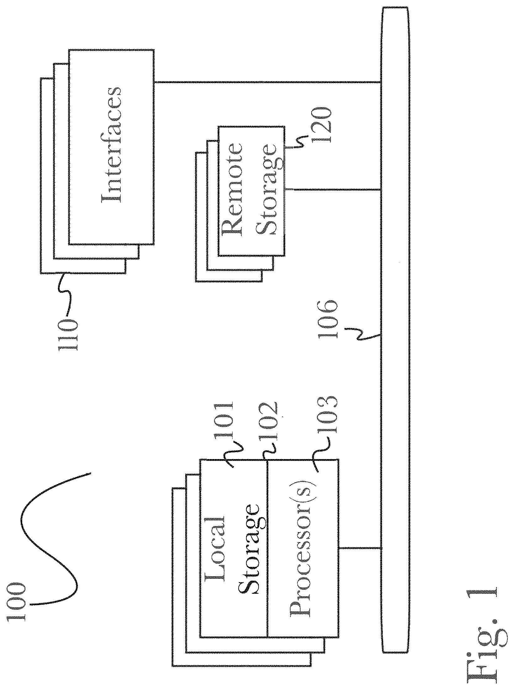
Referring now to FIG. 1, there is shown a block diagram depicting an exemplary computing device 100 suitable for implementing at least a portion of the features or functionalities disclosed herein. Computing device 100 may be, for example, any one of the computing machines listed in the previous paragraph, or indeed any other electronic device capable of executing software- or hardware-based instructions according to one or more programs stored in memory. Computing device 100 may be configured to communicate with a plurality of other computing devices, such as clients or servers, over communications networks such as a wide area network a metropolitan area network, a local area network, a wireless network, the Internet, or any other network, using known protocols for such communication, whether wireless or wired.
In one embodiment, computing device 100 includes one or more central processing units (CPU) 102, one or more interfaces 110, and one or more busses 106 (such as a peripheral component interconnect (PCI) bus). When acting under the control of appropriate software or firmware, CPU 102 may be responsible for implementing specific functions associated with the functions of a specifically configured computing device or machine. For example, in at least one embodiment, a computing device 100 may be configured or designed to function as a server system utilizing CPU 102, local memory 101 and/or remote memory 120, and interface(s) 110. In at least one embodiment, CPU 102 may be caused to perform one or more of the different types of functions and/or operations under the control of software modules or components, which for example, may include an operating system and any appropriate applications software, drivers, and the like.
CPU 102 may include one or more processors 103 such as, for example, a processor from one of the Intel, ARM, Qualcomm, and AMD families of microprocessors. In some embodiments, processors 103 may include specially designed hardware such as application-specific integrated circuits (ASICs), electrically erasable programmable read-only memories (EEPROMs), field-programmable gate arrays (FPGAs), and so forth, for controlling operations of computing device 100. In a specific embodiment, a local memory 101 (such as non-volatile random access memory (RAM) and/or read-only memory (ROM), including for example one or more levels of cached memory) may also form part of CPU 102. However, there are many different ways in which memory may be coupled to system 100. Memory 101 may be used for a variety of purposes such as, for example, caching and/or storing data, programming instructions, and the like. It should be further appreciated that CPU 102 may be one of a variety of system-on-a-chip (SOC) type hardware that may include additional hardware such as memory or graphics processing chips, such as a Qualcomm SNAPDRAGON.TM. or Samsung EXYNOS.TM. CPU as are becoming increasingly common in the art, such as for use in mobile devices or integrated devices.
As used herein, the term "processor" is not limited merely to those integrated circuits referred to in the art as a processor, a mobile processor, or a microprocessor, but broadly refers to a microcontroller, a microcomputer, a programmable logic controller, an application-specific integrated circuit, and any other programmable circuit.
In one embodiment, interfaces 110 are provided as network interface cards (NICs). Generally, NICs control the sending and receiving of data packets over a computer network; other types of interfaces 110 may for example support other peripherals used with computing device 100. Among the interfaces that may be provided are Ethernet interfaces, frame relay interfaces, cable interfaces, DSL interfaces, token ring interfaces, graphics interfaces, and the like. In addition, various types of interfaces may be provided such as, for example, universal serial bus (USB), Serial, Ethernet, FIREWIRE.TM., THUNDERBOLT.TM., PCI, parallel, radio frequency (RF), BLUETOOTH.TM., near-field communications (e.g., using near-field magnetics), 802.11 (WiFi), frame relay, TCP/IP, ISDN, fast Ethernet interfaces, Gigabit Ethernet interfaces, Serial ATA (SATA) or external SATA (ESATA) interfaces, high-definition multimedia interface (HDMI), digital visual interface (DVI), analog or digital audio interfaces, asynchronous transfer mode (ATM) interfaces, high-speed serial interface (HSSI) interfaces, Point of Sale (POS) interfaces, fiber data distributed interfaces (FDDIs), and the like. Generally, such interfaces 110 may include physical ports appropriate for communication with appropriate media. In some cases, they may also include an independent processor (such as a dedicated audio or video processor, as is common in the art for high-fidelity A/V hardware interfaces) and, in some instances, volatile and/or non-volatile memory (e.g., RAM).
Although the system shown in FIG. 1 illustrates one specific architecture for a computing device 100 for implementing one or more of the inventions described herein, it is by no means the only device architecture on which at least a portion of the features and techniques described herein may be implemented. For example, architectures having one or any number of processors 103 may be used, and such processors 103 may be present in a single device or distributed among any number of devices. In one embodiment, a single processor 103 handles communications as well as routing computations, while in other embodiments a separate dedicated communications processor may be provided. In various embodiments, different types of features or functionalities may be implemented in a system according to the invention that includes a client device (such as a tablet device or smartphone running client software) and server systems (such as a server system described in more detail below).
Regardless of network device configuration, the system of the present invention may employ one or more memories or memory modules (such as, for example, remote memory block 120 and local memory 101) configured to store data, program instructions for the general-purpose network operations, or other information relating to the functionality of the embodiments described herein (or any combinations of the above). Program instructions may control execution of or comprise an operating system and/or one or more applications, for example. Memory 120 or memories 101, 120 may also be configured to store data structures, configuration data, encryption data, historical system operations information, or any other specific or generic non-program information described herein.
Because such information and program instructions may be employed to implement one or more systems or methods described herein, at least some network device embodiments may include nontransitory machine-readable storage media, which, for example, may be configured or designed to store program instructions, state information, and the like for performing various operations described herein. Examples of such nontransitory machine-readable storage media include, but are not limited to, magnetic media such as hard disks, floppy disks, and magnetic tape; optical media such as CD-ROM disks; magneto-optical media such as optical disks, and hardware devices that are specially configured to store and perform program instructions, such as read-only memory devices (ROM), flash memory (as is common in mobile devices and integrated systems), solid state drives (SSD) and "hybrid SSD" storage drives that may combine physical components of solid state and hard disk drives in a single hardware device (as are becoming increasingly common in the art with regard to personal computers), memristor memory, random access memory (RAM), and the like. It should be appreciated that such storage means may be integral and non-removable (such as RAM hardware modules that may be soldered onto a motherboard or otherwise integrated into an electronic device), or they may be removable such as swappable flash memory modules (such as "thumb drives" or other removable media designed for rapidly exchanging physical storage devices), "hot-swappable" hard disk drives or solid state drives, removable optical storage discs, or other such removable media, and that such integral and removable storage media may be utilized interchangeably. Examples of program instructions include both object code, such as may be produced by a compiler, machine code, such as may be produced by an assembler or a linker, byte code, such as may be generated by for example a Java.TM. compiler and may be executed using a Java virtual machine or equivalent, or files containing higher level code that may be executed by the computer using an interpreter (for example, scripts written in Python, Perl, Ruby, Groovy, or any other scripting language).
In some embodiments, systems according to the present invention may be implemented on a standalone computing system. Referring now to FIG. 2, there is shown a block diagram depicting a typical exemplary architecture of one or more embodiments or components thereof on a standalone computing system. Computing device 200 includes processors 210 that may run software that carry out one or more functions or applications of embodiments of the invention, such as for example a client application 230. Processors 210 may carry out computing instructions under control of an operating system 220 such as, for example, a version of Microsoft's WINDOWS.TM. operating system, Apple's Mac OS/X or iOS operating systems, some variety of the Linux operating system, Google's ANDROID.TM. operating system, or the like. In many cases, one or more shared services 225 may be operable in system 200, and may be useful for providing common services to client applications 230. Services 225 may for example be WINDOWS.TM. services, user-space common services in a Linux environment, or any other type of common service architecture used with operating system 210. Input devices 270 may be of any type suitable for receiving user input, including for example a keyboard, touchscreen, microphone (for example, for voice input), mouse, touchpad, trackball, or any combination thereof. Output devices 260 may be of any type suitable for providing output to one or more users, whether remote or local to system 200, and may include for example one or more screens for visual output, speakers, printers, or any combination thereof. Memory 240 may be random-access memory having any structure and architecture known in the art, for use by processors 210, for example to run software. Storage devices 250 may be any magnetic, optical, mechanical, memristor, or electrical storage device for storage of data in digital form (such as those described above, referring to FIG. 1). Examples of storage devices 250 include flash memory, magnetic hard drive, CD-ROM, and/or the like.
In some embodiments, systems of the present invention may be implemented on a distributed computing network, such as one having any number of clients and/or servers. Referring now to FIG. 3, there is shown a block diagram depicting an exemplary architecture 300 for implementing at least a portion of a system according to an embodiment of the invention on a distributed computing network. According to the embodiment, any number of clients 330 may be provided. Each client 330 may run software for implementing client-side portions of the present invention; clients may comprise a system 200 such as that illustrated in FIG. 2. In addition, any number of servers 320 may be provided for handling requests received from one or more clients 330. Clients 330 and servers 320 may communicate with one another via one or more electronic networks 310, which may be in various embodiments any of the Internet, a wide area network, a mobile telephony network (such as CDMA or GSM cellular networks), a wireless network (such as WiFi, Wimax, LTE, and so forth), or a local area network (or indeed any network topology known in the art; the invention does not prefer any one network topology over any other). Networks 310 may be implemented using any known network protocols, including for example wired and/or wireless protocols.
In addition, in some embodiments, servers 320 may call external services 370 when needed to obtain additional information, or to refer to additional data concerning a particular call. Communications with external services 370 may take place, for example, via one or more networks 310. In various embodiments, external services 370 may comprise web-enabled services or functionality related to or installed on the hardware device itself. For example, in an embodiment where client applications 230 are implemented on a smartphone or other electronic device, client applications 230 may obtain information stored in a server system 320 in the cloud or on an external service 370 deployed on one or more of a particular enterprise's or user's premises.
In some embodiments of the invention, clients 330 or servers 320 (or both) may make use of one or more specialized services or appliances that may be deployed locally or remotely across one or more networks 310. For example, one or more databases 340 may be used or referred to by one or more embodiments of the invention. It should be understood by one having ordinary skill in the art that databases 340 may be arranged in a wide variety of architectures and using a wide variety of data access and manipulation means. For example, in various embodiments one or more databases 340 may comprise a relational database system using a structured query language (SQL), while others may comprise an alternative data storage technology such as those referred to in the art as "NoSQL" (for example, Hadoop Cassandra, Google BigTable, and so forth). In some embodiments, variant database architectures such as column-oriented databases, in-memory databases, clustered databases, distributed databases, or even flat file data repositories may be used according to the invention. It will be appreciated by one having ordinary skill in the art that any combination of known or future database technologies may be used as appropriate, unless a specific database technology or a specific arrangement of components is specified for a particular embodiment herein. Moreover, it should be appreciated that the term "database" as used herein may refer to a physical database machine, a cluster of machines acting as a single database system, or a logical database within an overall database management system. Unless a specific meaning is specified for a given use of the term "database", it should be construed to mean any of these senses of the word, all of which are understood as a plain meaning of the term "database" by those having ordinary skill in the art.
Similarly, most embodiments of the invention may make use of one or more security systems 360 and configuration systems 350. Security and configuration management are common information technology (IT) and web functions, and some amount of each are generally associated with any IT or web systems. It should be understood by one having ordinary skill in the art that any configuration or security subsystems known in the art now or in the future may be used in conjunction with embodiments of the invention without limitation, unless a specific security 360 or configuration system 350 or approach is specifically required by the description of any specific embodiment.
FIG. 8 shows an exemplary overview of a computer system 800 as may be used in any of the various locations throughout the system. It is exemplary of any computer that may execute code to process data. Various modifications and changes may be made to computer system 800 without departing from the broader scope of the system and method disclosed herein. CPU 801 is connected to bus 802, to which bus is also connected memory 803, nonvolatile memory 804, display 807, I/O unit 808, and network interface card (NIC) 813. I/O unit 808 may, typically, be connected to keyboard 809, pointing device 810, hard disk 812, and real-time clock 811. NIC 813 connects to network 814, which may be the Internet or a local network, which local network may or may not have connections to the Internet. Also shown as part of system 800 is power supply unit 805 connected, in this example, to ac supply 806. Not shown are batteries that could be present, and many other devices and modifications that are well known but are not applicable to the specific novel functions of the current system and method disclosed herein. It should be appreciated that some or all components illustrated may be combined, such as in various integrated applications (for example, Qualcomm or Samsung SOC-based devices), or whenever it may be appropriate to combine multiple capabilities or functions into a single hardware device (for instance, in mobile devices such as smartphones, video game consoles, in-vehicle computer systems such as navigation or multimedia systems in automobiles, or other integrated hardware devices).
In various embodiments, functionality for implementing systems or methods of the present invention may be distributed among any number of client and/or server components. For example, various software modules may be implemented for performing various functions in connection with the present invention, and such modules may be variously implemented to run on server and/or client components.
Description of System Architecture
FIG. 4 is a diagram of an exemplary architecture for a platform 400 for crowdsourced image analysis, according to a preferred embodiment of the invention. According to the embodiment, crowdsourcing is accomplished by distributing image analysis tasks to various participant users, who typically access platform 400 via Internet 401 from tablet devices 415, laptops 413, personal computers 410 with monitors 411, or other Internet-accessible computing devices. Access to platform 400 is typically, although not necessarily, made using a browser 412, 414, 416 (or a similar Internet-connected software application). As is typical of Web applications, platform 400 may be accessed by participating users via web server 430, which may comprise web server software such as Microsoft Internet Information Server, Apache Web Server, IBM Websphere Web Server, or any other web server known in the art, stored and operating on a single network-attached server computer or a cluster of server computers, or it may comprise such software operating on a plurality of such machines, and may be placed behind a load balancer (not shown) that distributes requests among the various instances of web server 430. As is typical of Web applications, participant user requests pass from browsers 412, 414, 416 via Internet 401 to web server 430, which stores and returns static web page elements locally, and passes application-specific requests to application server 431. Application server 431 may be any particular form of application server known in the art, such as Apache Tomcat or Geronimo, Java Platform Enterprise Edition, RedHat JBoss AS, Windows Server, or IBM WebSphere Application Server; further, it will be understood by one having ordinary skill in the art that this list is merely exemplary and is in no way limiting. Application server 431 may comprise application server software stored and operating on a single network-attached server computer, or it may comprise such software operating on a plurality of such machines, and may be placed behind a load balancer (not shown) that distributes requests among the various instances of application server 431. As is common in the art, application server 431 uses a database 432 to store application-specific data. Typically (although not necessarily), application server 431 will offer a stateless representation state transfer (REST) application programming interface (API) to users via web server 430, and accordingly all application state data is maintained in database 432, which facilitates scalable operations (since each application server 431 instance is not required to maintain state information separately, and since the need for complex state propagation between application servers is thereby eliminated. Of course, it will be appreciated by one having ordinary skill in the art that the general architecture of a web server 430 coupled to an application server 431 via a REST API, with database 432 storage of application data, is typical of scalable web applications but is also merely exemplary. It may be desirable in some cases for a client-server connection between dedicated applications 412, 414, 416 and a dedicated server software 431 that uses a proprietary interface and could even be a stateful server application.
With this basic architecture in mind regarding the connections between participating users and application server 432, specific aspects of the invention will now be described. Before participating users can participate in a crowdsourcing campaign, a requesting entity must set up the campaign. Requesting entity (and administrative) users interact with application server 431 via the Internet 401 and web server 430 just as participating users do; a single PC 420 with monitor 421 and browser 422 is shown in FIG. 4 to represent administrative and requesting entity users (it should be noted of course that only PC 420 is shown for brevity; as with participating users, administrative/requesting entity users may use any suitable Internet-capable computing device according to the invention). Requesting entity users will generally create and manage crowdsourced image analysis campaigns, and will view results of such campaigns (possibly adjusting the settings of such campaigns as a result of such reviews, to improve the performance of such campaigns). Once a campaign is set up, it may be activated by the requesting entity, at which point participating users may "join" the campaign and thereupon start receiving image analysis tasks associated with the campaign to perform. In a preferred embodiment, images are delivered form database 432 to participating users by application server 431 via web server 430, and participating users interact with such images in web browsers 412, 414, 416 using tools provided by application server 432. In some embodiments, however, third party crowdsourcing platforms such as Amazon's Mechanical Turk 450 may be used to manage a crowdsourced image analysis campaign using images and requirements provided by application server 431 or directly from database 432.
As noted above in the background section, one common challenge in search and locate problems, which is not addressed by current crowdsourcing techniques (which, as noted, use either or both of the work distribution with quality measurement and the democratic/voting techniques), is the problem of accurately finding and locating targets of interest using crowdsourcing. The shortcomings of the two main crowdsourcing approaches (work distribution and voting) are different for each approach. The work distribution approach is still useful in search and locate problems, but it is not adequate by itself, as it does not provide a means for locating targets of interest, particularly when many participating users "tag" the same target of interest, often with varying locations (generally nearby, but in some cases even quite distant from each other). The voting approach, while excellent for ranking reputations (is this a good song or not?) or for classification problems (is this a tank or not?), does not handle continuous variations of input data well. That is, voting is good when there is a small set of possible options (which is this: a dog, a cat, or a skunk?); the resulting tallies for each discrete element of the set can be compared and a "winner" selected (it's a cat). But when the input provided by participating users is not only the presence of an object but also its two-dimensional location (or even three-dimensional location), the simple voting approach does not help to answer the question, "where is it, really?"
Accordingly, in a preferred embodiment platform 400 further comprises a crowdsourced search and locate service 440, which may be stored and operating on a single network-attached server coupled to application server 431. In some embodiments, crowdsourced search and locate service 440 operates on a large number of independent machines whose activities may be coordinated using an approach such as the well-known map/reduce technique. crowdsourced search and locate service 440 takes as inputs a (typically large) set of tags from many participating users. Fundamentally, crowdsourced search and locate service 440 implements a crowdsourced search and locate service algorithm (described in detail below) that attempts to determine a "most likely" set of targets that are present in an image, using a large amount of tagging data obtained from participating users viewing the same or related images. Because location tagging is an inherently noisy process (people vary widely, at a minimum; in addition, some viewers may view an image at higher resolution than others, while some may tag an extensive object at its centroid while others tag it at various points on its edges, and so forth). Therefore, it will usually be the case that tag data input to the crowdsourced search and locate service 440 is very noisy; for example, if there are several targets of interest close to each other "in the real world" (i.e., in the place from which the image was taken, at the time the image was taken), the inevitable inaccuracies in users' tagging may result in (for example) a single cloud of nearby tags that might be interpreted as belonging to a single target of large extent but actually belongs to two or more "real" targets. The crowdsourced search and locate algorithm may optionally take as input one or more sets of prior data, for instance regarding the quality of a specific set of participating users' previous tagging work; such prior data may (as described below) be used to improve the time to convergence of the algorithm. In some embodiments, prior data may also be used to improve accuracy of the algorithm, instead of (or in addition to) improving its convergence time. For example, if a known-malicious user is given a prior that says he is a poor tagger, his input will be ignored instead of calculated into the mix. In some cases, the algorithm might not arrive at the conclusion that a particular user is malicious, but if his prior data suggests so, it may be more likely to be detectable by the algorithm. Given these inputs, the crowdsourced search and locate algorithm uses an iterative expectation-maximization process to generate, as outputs, three sets of data (although conventionally maximization processes are used after an expectation of maximum likelihood, it should be noted that, where convenient, the algorithm can be conducted using a numerical minimization approach by simply mapping variables in a corresponding way). The first is an array of quality scores for the taggers (the participating users who created tags as part of the crowdsourcing campaign whose data is being analyzed by the crowdsourced search and locate algorithm). The second is an array of difficulty scores for each tagged target. The third is an array of estimated locations of actual targets, comprising for each target data such as the latitude and longitude of the target, the type of the target (tank, railroad car, damaged building, debris field, etc.), and a confidence level in the identification.
Fundamentally, the crowdsourced search and locate algorithm is focused on identifying an underlying hidden variable (the real targets that existed at a time of interest) using incomplete data (the tagging data, which won't necessarily have tags for all of the real targets, and which may have many tags for each real target). In order to move from the inputs (principally tag data, each tag comprising a tag identifier, a tagger identifier, a location (latitude and longitude, or a UTM grid point and easting and northing values for the offset from that UTM grid point), the crowdsourced search and locate algorithm carries out a key data transformation, then uses a modified iterative expectation-maximization (EM) algorithm to generate a set of intermediate outputs, then performs a clustering on the interim outputs to arrive at the final crowdsourced search and locate output. The details will be described below, but at a high level the initial data transformation involves converting straightforward geolocation information (a series of tags generated by participating users) into a set of agreement/disagreement data (meaning agreement or disagreement among the participating users of the input set). Also, since EM algorithms known in the art take an input vector and a parameter vector and attempt to identify a vector corresponding to a hidden variable of which the input vector represents a (possibly noisy) subset, in the crowdsourced search and locate algorithm the vector of quality scores and the vector of difficulty scores are mathematically combined and treated as the parameter vector for EM algorithm purposes.
From a use case perspective, what is accomplished using platform 400 includes: setting up (by requesting entities) image analysis campaigns; running the campaigns to generate tag sets from participating users; displaying the results to one or more requesting entity users; and using the crowdsourced search and locate algorithm with the results as input to generate an estimate of ground truth (that is, an estimate of the actual targets of interest and their locations) and displaying or disseminating the same to the requesting entity users (for example, by auto-generating kml/kmz files, and making the resulting output available via a REST API for consumption by users' workflows).
FIG. 14 is a block diagram illustrating an exemplary system architecture for a system 1400 for analysis of geolocation data of social content, according to a preferred embodiment of the invention. As illustrated, system 1400 may comprise a number of components such as (but not limited to) a metadata storage 1401, social search engine 1402, geolocation module 1403, a plurality of relevancy modules 1404, and a media storage 1405. As illustrated, a plurality of components may be connected and in communication with Internet 1410 or another communications network via a web infrastructure 1420 comprising components common in the art such as a web server 1421, which may handle communication with other network-enabled services or devices, an application server 1422, which may handle communications between a web server and components of system 1400 as well as storage of data in a database 1423 or other storage medium for access by both elements of system 1400 and elements of web infrastructure 1420 (such as stored webpage elements or search histories), as may be desirable for retrieval of social media content or other information during system operation. It will be appreciated that such communication with an external network is not necessary for a system 1400 to function, and that in some cases it may be desirable to use the function of system 1400 on locally-stored data alone rather than accessing it over a network, such as (for example) analyzing a static repository of social media content-that is, a stored quantity of content that is not connected to a communications network and is not subject to change. Such an implementation might be useful, for example, for analyzing a large quantity of social media content stored in a database 1405 for the purpose of improving a metadata storage 1401 or simply as a test of function (where output data might be examined for relevancy and usefulness to determine the operational quality of a system 1400).
Storage devices illustrated may be accessed in a bidirectional manner by other components of system 1400. That is, they may be accessed both for retrieval of storage data as well as to store new data as appropriate during operation. For example, a social search engine 1402 might encounter new metadata in the results of a search of content over a network 1410, and store this data for future reference. In this manner, stored data may be continually evolving and increasing in granularity and relevancy, improving function of a system 1400 as well as relevancy of content output.
A social search engine 1402 may access content stored locally (such as in a media storage 1405), or content hosted across a network such as an Internet 1410. Such content may be of varied nature, and uploaded by users via various devices such as a personal computer 1412, tablet or smartphone computing device 1413, or any similar networking-enabled devices as are common in the art. Media that is retrieved may be stored in a media storage 1405 and passed to other components of system 1400 for processing, such as geolocation module 1403 or relevancy modules 1404, each of which are described in detail below.
A geolocation module 1403 may receive content from a social search engine 1402 (or may retrieve content previously posted on a social network that has been stored in a database such as media storage 1405), and may further communicate with a network 1410 as appropriate, such as to perform further search and analysis of content utilizing known geolocation data (for example, if a person uploading media content has previously made his location known), and using other data to attempt to determine new geolocation data if needed (such as searching a user's previous posts to determine if a location was ever revealed). Geolocation module 1403 may be utilized to analyze metadata of social content and use such data to determine geolocation data (for example, by performing further searches on a network 1410 for content relevant to known metadata such as a content poster's previously-recorded locations). The methods by which geolocation data may be determined are discussed in greater detail below, referring to FIG. 15.
Geolocation module 1403 may then present content (which may now be refined with additional geolocation data that was not present in the content initially) to a plurality of relevancy modules 1404 (only one illustrated for brevity, however it will be appreciated that a plurality of modules may be utilized as appropriate according to the invention), which may then perform additional analysis of media, metadata, and geolocation data to determine the relevancy of such data. In this manner, content may be accurately scored prior to final storage, so that potential irrelevant information does not lead to erroneous output (for example, if a user's last known location was recorded several years prior, it may be scored lower with respect to relevancy, as they may have changed location since then). This scored, refined content may then be stored in a database such as media storage 1405, where it may be accessed by other systems for use (such as retrieving social media content for overlay on a map display, now that geolocation information is known).
Description of Method Embodiments
FIG. 5 is a process flow diagram of a method 500 to allow a plurality of users to participate in crowdsourced image analysis, according to a preferred embodiment of the invention. According to the embodiment, in step 501 a participating user may register with platform 400 (thereby obtaining a user identifier), and once registered, may log in to platform 400 in order to participate in one or more crowdsourced image analysis campaigns. It will be appreciated by one having ordinary skill in the art that there is a variety of information that may be obtained by platform 400 during user registration, such as user name, user background, type of user (volunteer, paid, etc.), organizational membership, tagger group memberships, and the like. For example, a new user may register as a member of an organization that is focused on a particular campaign, set of campaigns, or type of campaigns (for example, a "league of armchair military analysts", whose members focus only on military analysis, such as tracking developments in combat areas such as Syria or Mali); alternatively or also, a user may register as a member of one or more existing "tagger groups" (such as search and rescue, climate change damage assessment, and so forth). In some embodiments, "passive login", such as logging in using Facebook.TM. or Mechanical Turk.TM. credentials, may be provided; for example, a user may be logged in automatically with an identifier corresponding to his Mechanical Turk.TM. or Facebook.TM. identifier, and the user would therefore not see a login process occurring. Once a participating user has logged in, he may be presented with a list of active campaigns for which he is eligible (campaigns may be unrestricted, meaning every registered user is eligible to participate, or they may be limited to participating users from specific organizations or tagger groups, or to participating users who satisfy some criterion such as experience level, average quality rating, Mechanical Turk.TM. qualification, etc.). Upon viewing such a list of available campaigns, in step 502 the user may select a campaign in which he wishes to participate; alternatively, in step 502 platform 400 may automatically assign the user to a specific campaign upon login. In support of the selection process of step 502 (when performed manually by a participating user), the user may be shown a list (using any of the many well-established user interface conventions for displaying lists from which selections are to be made) of available campaigns that the specific user may participate in. In some embodiments, some campaigns may be limited to certain classes or groups of participating users; for example, a sensitive law enforcement campaign may only be made available/visible to qualified law enforcement personnel (this may actually occur, for example, when a high-profile search for a target is needed, and law enforcement personnel from a wide variety of agencies may desire to assist informally, without sensitive information being divulged to the public at large). In some embodiments, campaigns may be assigned automatically by platform 400 in step 502, for instance where new participating users are assigned to a specific training campaign until they complete the required training or otherwise demonstrate proficiency.
Once a campaign has been selected by or for a participating user, in step 503 the user may navigate to a specific map section to carry out tagging operations (that is, to attempt to identify and locate targets of interest in the map section to which the user has navigated). Again, as in campaign selection, in some embodiments automated action may be taken in step 503, rather than allowing a user to manually select a map section for viewing. For example, it may be important that users are not provided information about the actual map location (that is, grid coordinates or latitude and longitude) of map sections as they view them and carry out tagging operations. In some cases, it may be important that users are unable to identify the actual, physical location of a target of interest on the earth's surface (for instance, to prevent looting of valuable archaeological sites). Accordingly, users may be "navigated" automatically in step 503, by being shown successive map sections without their spatial locations or relationships being known. In some embodiments, platform 400 may enforce a sampling regimen wherein various map segments are assigned probability levels (of having targets of interest in them) or interest levels, and the number of participating users who are encouraged or made to view specific map sections may vary accordingly (more users might be assigned to more interesting, promising, or difficult map sections). Similarly, in some embodiments users may be provided an option to manually navigate or to have the system navigate for them (for instance, they could be provided a "next" button, or a "surprise me" button, as well as a small map of an entire interesting region via which they can manually navigate by selecting a map segment using for example a computer mouse or a touchpad). Once a participating user is "in" (i.e., viewing) a particular map segment, the user tags all relevant objects (targets of interest) in that section in step 504 (of course, it should be apparent that not all users will find all actual targets in any given map segment; skill, persistence, and interest level--among other variables--may cause some to tag only a subset, and others to tag false targets of interest, and so forth). In some embodiments, in step 505 a participating user may view agreement data while tagging objects. For example, when a user moves a graphical cursor to a specific map location and selects an action (e.g., "tag as tank"), a graphical indicia may be displayed advising the user how many other users placed a similar tag there (or within a reasonable--and configurable--distance from the user's cursor location); in some embodiments, a second graphical indicia such, as a colored cursor, may be provided to indicate a position of the centroid of a set of other users' tags, effectively indicating to the participating user information such as, "ten other people tagged a tank, but the group locates the tank at this slightly different location". Accordingly, users may be provided a means to edit their tags (for example, by clicking and dragging their tag onto the marked centroid position, or to adjust its position relative to an underlying image feature, as desired). When editing is completed in step 505, a user may simply move on to make another tag, or may be provided with a positive confirmation means, such as a clickable "Tag" button, to indicate that a particular tag will no longer be edited, but a new tag may be placed in the current map segment. In some embodiments, some or all users may not be shown agreement data, for example to encourage "open minded" tagging by suppressing feedback from other users' activities.
In step 508, once a participating user is finished tagging objects in a specific map section (typically, because either the user is bored with a particular map section, or the user believes she has tagged all targets of interest), the user may navigate to another map section (again, manually or automatically), and resume carrying out method 500 in step 504. In step 507, when a user is finished, either because the user decides to complete their tagging session, or because a campaign setting is reached (for instance, a campaign might specify that no user should do more than ten map sections at a time), then in step 509 the user exits method 500 (typically by navigating away from the web page provided by platform 400 for participating users).
FIG. 6 is a process flow diagram of a method 600 for estimating location and quality of a set of geolocation data based on tag data provided by a plurality of users of a crowdsourced image analysis platform of the invention. In a first step 601, a set L of tags made by participating users (using method 500) for a particular campaign is loaded as input to method 600. Typically, each tag will comprise a tag identifier, a tagger identifier (each participating user is given a unique identifier, and all tags made by a specific participating user will have the same tagger identifier), a location (either latitude and longitude, or UTM grid plus easting and northing values, or another geospatial reference location), and a type of tag (for example, "tank", "debris field", "building", and the like). Of course, other data elements may be provided as well, such as overlay identifiers (when multi-layer maps and tagging are used), but the core elements of tag identifier, tagger identifier, tag type, and tag location will generally always be present. In step 602, each tag in L in turn has agreement and disagreement values computed. This is done by taking a specific tag and then looping over all other tags in L. The specific tag may be given an agreement value of 1 (because it by definition agrees with itself; of course, values other than 1 may be used for agreement, according to the invention). For each other tag that is considered with respect to the specific tag, a distance computation is made from the specific tag to the other tag. In a preferred embodiment, if the computed distance is less than a first specified (configurable) value (i.e., the other tag is "close" to the specific tag), then a new entry is added to L for the other tag, and an agreement value of 1 is assigned; if the distance is more than the first specified value but less than a second specified (also configurable) value (the second specific value always being greater than the first specific value), then the other tag is "sort of close" to the specific tag, and a new entry is added to L for the other tag, with an agreement value of 0 (disagreement; as in the case of agreement, a value other than 0 can be used in some embodiments); finally, if the computed distance is greater than the second specific value, then the other tag is considered unrelated to the specific tag, and no new element is added to L. It should be clear that, upon completion of step 602, a vector of tags L that initially had length Len(L) will now be much larger, having a length given by X*Len(L), where X is the average number of new entries added per tag (that is, the average number of tags that are either close or sort of close to a given tag); furthermore, each element in L will, after step 602, have an agreement/disagreement value.
It should be noted that the method just described is one way of assigning "agreement" and "disagreement" values; others are possible according to the invention as well. For example, consider that the radius may represent a circular "kernel" with the tag of interest at its center. If another tag were inside the kernel, it could be considered to agree with the tag of interest. One can then extend the idea of a kernel to include any arbitrary shapes (and one can assign agreement values that are between zero and one, for example depending on distance from the center). As an example of such an approach, when detecting roads or other straight-line type of features, the kernel could be a long skinny ellipse. The ellipse could be rotated through all possible angles; the angle for which the highest number of other nearby tags "agree" would be the one that is chosen and then used to establish agreement and disagreement values (which again may be binary or continuously-valued). Of course, other shapes could also be rotated; for example, an "X" shape could be used to detect road intersections. Similarly, disagreement also can be assigned in many possible ways. The way described above corresponds to a disagreeing tag's falling inside of one kernel while falling outside of another. Or, a tagger who views an area of another user's tag but does not "agree" automatically disagrees. In this case, it is not a tag "disagreeing" with another tag, but rather it is another user disagreeing with a tag of interest. In some embodiments, it is desirable to send users to a specific, discrete set of locations, in order that it may be definitely established that two or more users saw exactly the same thing, in which case disagreement can be more readily ascertained (and with a higher degree of confidence).
Once L has been expanded as described in step 602, in step 603 initial values are assigned for arrays A, B, and Z. A is an array comprising one element for each unique tagger (participating user) who has provided at least one tag to L. Each element of A may comprise a tagger identifier (the unique identifier for a specific participating user), a mean quality of tags made by the specific tagger, and a standard deviation of the quality of tags made by the specific tagger. "Quality" means, in a preferred embodiment, a value from -1 to 1, where -1 means the specific tag by a specific tagger is completely malicious (known to be false), 1 means the specific tag by the specific tagger is completely trustworthy (known to be true), a value less than 0 but not equal to -1 means the tag is more likely than not to be malicious, and a value greater than 0 but less than 1 means the tag is more likely than not to be reasonable (i.e., not malicious). A value of 0 indicates that a tag is inaccurate but not malicious. Initial values of the elements in A may be either loaded from database 432 as priors, or may be instantiated (for each tagger identifier) with default values (such as 0 mean, 0 standard deviation). Similarly, quality values may be assigned based on disagreement; for instance, a user may see a really obvious object to tag and not tag it, either because he is inept or malicious. Each element of B may comprise a tag identifier (the unique identifier for a specific tag), a mean difficulty of the tag as made by various taggers (that is, if many taggers identified a "tank" at a location, the difficulty scores for each such tag are averaged), and a standard deviation of the difficulty of the tag as made by various taggers. "Difficulty" means, in a preferred embodiment, a value from 0 to 1, where 0 means the specific tag is "very easy" (very likely to be correctly tagged by a random tagger), and 1 means the specific tag is "very hard" (very unlikely to be correctly tagged by a random tagger). Initial values of the elements in B may be either loaded from database 432 as priors, or may be instantiated (for each tag identifier) with default values (such as 0.5 mean, 0 standard deviation). Each element of Z may comprise a tag identifier (the unique identifier for a specific tag), and a probability value, which represents the probability that the specific tag is correct (meaning it correctly tags a real object). Initial values of the elements in Z may be either loaded from database 432 as priors, or may be instantiated (for each tag identifier) with default values for the probabilities for each tag (such as 0.5). Recall that L is a set of input obtained from users attempting to tag objects in images; it is assumed that there is a hidden variable representing the set of all actual targets of interest in the region covered by the images, so the probabilities in Z represent the likelihood that a given tag represents an actual object in the specific geospatial location associated with the tag in question. The goal of method 600 is to obtain maximized (at least locally) values of Z, given parameter sets A and B. Accordingly, in step 604 (the expectation step), an expectation of the maximum likelihood P that Z reflects the underlying hidden variable (the actual targets of interest in the image field), given the parameter vectors A and B, is computed in the normal way using the current values of A and B. Then, in step 605, vectors A and B are merged into a single vector AB (note that each element of A and of B has form {ID, Mean, StdDev}, so merging the two vectors--by concatenation--creates a single vector comprising elements of the same form), in preparation for carrying out the maximization step. Then, in step 606, the maximization step is carried out by estimating a new value AB.sub.n+1 based on AB.sub.n by iteratively computing the argument of the maximum of Q(Z|AB.sub.n) over all Z, where Q is computed in the normal way. Once this is done, the vector AB is unpacked into its components A and B in step 607, and in step 608 a test is made to determine whether either a configured maximum number of EM iterations has occurred (requiring termination to avoid possible endless loops and to limit the time of operation of the crowdsourced search and locate algorithm) or whether the change in AB is less than a configured minimum (meaning convergence has occurred); if either of these conditions is met, then method 600 moves to step 610 and the final values of A, B, and Z are output by crowdsourced search and locate service 440 to the user or application that originally requested the crowdsourced search and locate algorithm to be executed. If neither of the conditions of step 608 is met, then in step 609 the new values of A and B (taken from the unpacked AB.sub.n+1) and Z (determined as part of the maximization step) are returned and execution resumes again at step 604, for another iteration of the EM algorithm.
FIG. 7 is a process flow diagram of a method 700 to accurately geolocate a plurality of targets using a crowdsourced image analysis platform of the invention. Once the method 600 has been carried out, an array of tags and their probabilities (that is, Z) is available, but it is still unclear what a set of real or actual targets of interest in the region covered by the images from which the tags were made is. For example, many of the tags in Z may be duplicates of other tags (for instance, if several different taggers tag the same object), and the precise location of each real object is yet to be determined. It should be evident that such locations are likely to be closest to the corresponding tag that has the highest probability value (recall that Z comprises tuples of {tag ID, probability}). Accordingly, a clustering method 700 is provided in various embodiments of the invention. Upon commencing method 700, in step 701 all of the points in Z are ordered (sorted) by tag quality (that is, by the probability of each tag's being correct). Then, in step 702 a check is made to see if any tags remain in the list; if none do, execution passes to step 707 and the output of all selected tags is printed or returned to a requesting entity. Otherwise, in step 703 the next tag T (by definition, the highest remaining tag in order of probability/quality) is selected. In step 704, the quality score or probability of tag T is checked to see if it is below a defined (configurable) threshold. If it is below the threshold, then execution jumps to step 707 and the output of all selected tags is printed or returned to a requesting entity. If the quality score of tag T in step 704 is above the threshold, then execution continues to step 705. In effect, step 704 and the threshold it uses together mean that all tags whose quality is below the configured threshold are discarded and never placed into the output buffer that is passed to step 707. In step 705, all tags (necessarily below T in the list Z) that are close to T (that is, whose geospatial distance from T is less than a configured distance, which may or may not be the same as the first specific distance used in method 600; or all tags that are inside a specific agreement kernel) are discarded from the list, and in step 706 tag T is added to an output buffer (which starts as an empty buffer before step 701), and tag T is removed from list Z (note that in most embodiments a "working copy" of Z would be used in method 700, so the full original Z is maintained for use elsewhere). Once T has been added to the output buffer and removed from Z (or "the working copy of Z"), execution returns to step 702. Thus it will be apparent to one having ordinary skill in the art that the clustering approach of method 700 starts with Z (and gets location data from L using the tag identifier in each element of Z), and works down the list in order of probability (quality), taking each tag T, removing its nearby neighbors from the list, adding T to the output, and removing T from the list until either the list is emptied or the next tag T has a quality that falls below a defined threshold. Thus for each tag T' in the output when execution passes to step 707, there is a strong likelihood that the object specified by tag T' actually exists, and that the output contains no duplicates. It will be apparent that the setting of the "closeness parameter" used in step 705 is an important parameter, since in general if two real objects exist in the region covered by the image set used, and their real distance is less than the "closeness parameter," method 700 will likely report only one target in step 707. This would argue for a low value of the closeness parameter; however, a very low value of the closeness parameter would result in many duplicate objects in the output of step 707 if it is set to a value lower than or close to the average error in tag location made by users. Fortunately, since the computational cost of methods 600 and 700 is quite low for reasonably sized datasets, it is quite practical for a requesting entity to run the crowdsourced search and locate algorithm (the methods 600 and 700) multiple times, with different parameter settings, during a single analysis session, to determine an optimal setting for a given campaign (optimality will depend on the type and size of targets sought, image resolution, participating user experience, and so forth).
Description of Crowdsourcing Method Embodiments
Crowdsourcing has been done in many ways. However, in the case of crowdsourcing to obtain data for editing and correcting map data, many improvements can be made to the process, thus improving the reliability and predictability of maps. For example, ranking the quality of the output of each crowdsourcing participant enables the map makers to understand the particular skills and abilities of each participant in various areas, such as, for example, skills and knowledge for urban areas, for mountain areas, for large infrastructure areas, etc. Additionally, some machine interpretations of the initial image data may be used to create the framework as a starting point. Additionally, map data from other sources may be combined, and the combination presented to participants. In some cases, participants may get map data to work on where already a good map exists to accurately identify how the quality of said participant's output may compare to the quality of a normalized aggregate crowdsourcing community output. Of course, the assignment of image chips and map data to participants may be randomized to reduce the opportunity to introduce fraudulent or other malice-motivated data into the system. In other cases, it may desirable to use some other a prior knowledge to assign people to non-random locations. Also, each image chip is typically sent to a number of participants, which number may vary from as few as three or five up to more than 100, depending on the importance and the size and scope of the project.
Comparing the performance of map data annotations by various participants on known areas that already have accurate map data and also noting differences in performance on different types of terrains enables highly accurate ranking of the capabilities of each participant, so that the system can determine which participants are best employed on which type of terrain, not just in global terms across all terrains, but in relative terms for different types of imagery. Further, the preprocessing of the raw imagery enables the system to determine which participants should get which image chips to get the best results in the quickest way.
Other sources of map data may be, for example, existing map systems, open source map systems, commercial or government maps, etc.
The resulting improved maps may be used by government agencies as well as non-government organizations (NGOs), and commercial organizations to provide valuable services to areas that don't currently have sufficiently accurate maps and/or infrastructure.
FIG. 9 shows a high-level data flow 900 of the system, in which scalable hosting and processing are followed by a tight quality control loop to keep the crowd engaged, producing accurate information and verifying road data. In step 901 data is acquired during flyovers of vehicles such as, for example, airplanes, satellites, drones, UAVs, etc. In step 902 the acquired data is processed and hosted in a cloud system, which system is described herein earlier and throughout. In step 903 particular images are selected to for editing, for example using a map editor (although other user interface elements may be used to select images for editing, according to the invention). In step 904 the selected data is verified, using CROWDRANK.TM. VEVS. In step 905 a predictive analysis engine 1101 is used to verify that the previous steps have been done correctly, and based on the analysis, a community is ranked and selected. Predictive analysis engine 1101 is a program that can recognize that a map is coherent. In step 906 a community selection process is conducted, which may for example assign particular members of a community to specific crowdsourcing work (i.e., by assigning them specific images for reviewing, or assigning them to a particular high-priority campaign, etc.). Assignments may be made based on various factors in step 906, including for example (but not limited to) use of a graphical community selection tool by a human campaign administrator; random assignment of community users; assignment of users based on predictive analytics; optimized assignment of users based on analysis of past performance; and so forth. The process of steps 903 through 906 may require several rounds 907 before predictive analysis engine 1101 is satisfied with the results and that the data makes sense.
FIG. 10 shows a verification process 1000 using the CROWDRANK.TM. VEVS. Open Street Map (OSM) vectors 1001 and image chips 1002 from which the OSM vectors were derived are overlaid on each other. The data is then sent to crowdsourcing participants for the verification process. Regions are prioritized based on their importance, such as, for example, their impact on the humanitarian community. They are also ranked for data reliability. The participants can then edit and correct the map to help improve the image, using a crowdsourced image and map data system (CIMDS) 1006. VectorUpdate.TM. within the crowdsourcing system is part of RoadTracker, which is a software system to create vectors by following linear shapes in images, assuming they are roads (or, secondarily, other linear types of infrastructure, including, but not limited to, railroads, pipelines, walls, etc. The vector reliability score 1003 is calculated by comparing crowdsourced vectors against the calculated vectors and by incorporating additional information such as crowd agreement, crowd metadata information, and other information about the vector modifications. Vector updates may then be inserted to help fill in recognizable objects and areas, such as roads, geographical features, etc. Crowdsourcing may provide an effective means of validating or correcting automated vector updates. The user reliability score 1004 is calculated by calculating the deviation of a given user from the crowd, to identify the likelihood that certain users may contribute wrong information. Suspect information is compared to the crowd's determination and then either accepted or rejected, with some notation of it referring to where it should be inserted, noting that if a normally very reliable user has difficulty, the terrain should probably be considered difficult. Generating a reliability score adds statistical rigor to the peer review process. The likelihood of these reliability scores is based on machine learning. Then the data is assessed for difficulty 1005 in digitizing that particular region, which is one of a set of chips in an area, based on the degree of accuracy and the spread of the reliability scores, both for users and for vectors. When the reliability scores are acceptably high, predictive analysis engine 1101 is used to increase the predictive analytics capability of the system and method disclosed herein, as described below.
FIG. 11 shows how predictive analysis engine 1101 (which is the same predictive analysis engine described earlier in the discussion of step 905 in FIG. 9) has all the data together. Various vector fields and other demographic data from various sources are combined into layers, shown, in this example, as layers 1102 through 110x. More layers are possible, as indicated by the dashed line between 1104 and 110x. Predictive analysis engine 1101 combines the layers, based on the reliability scores, and produces predictive map 1006 that contains all the gathered and validated data. This map may be used for all kinds of further analyses, both in-house and in the field. A high level analyst has the capabilities required to bring domain and local knowledge together for effective prioritization.
FIG. 12 shows the process 1200 of the continuing data editing and corrections. As described above and throughout, vector reliability score 1202, the degree of difficulty of region digitization 1203, user reliability scores 1204, and prediction map 1205 from the system analyst are all taken into account in a crowdsourcing targets and member selection system (CTMS) such as, for example, Community Selector, which selects prioritized regions 1207 and associated users 1208 (crowd members), based on their reliability score, to continue to refine and correct data.
FIG. 13 shows a linear process flow of crowdsourced map data cleanup and correction system 1300. In step 1301, an application server receives data from crowdsourcing participants. In step 1302, the application server uses said data to create image chips for segments of map data to be created or cleaned up. In step 1303 the server sends an image with any available corresponding data to crowd-sourcing participants, and in step 1304 it receives tagging and/or correction data from crowdsourcing participants. In step 1305 the crowdsourced search and locate server retrieves tags and/or corrections made by crowdsourcing participants by repeated iterations of steps 1301 through 1304. In step 1306 the crowdsourced search and locate server computes agreement and disagreement values for each retrieved tag. The server then in step 1307 performs an expectation-maximization or expectation-minimization process iteratively until a configured maximum number of iterations is performed or until an indicia of rate of change between iterations falls below a configured threshold. In step 1308 the server then outputs map data to an administrative user. In some cases, the image chips may contain three-dimensional viewable images of an area, aiding crowd-sourcing participants to better recognize difficult objects.
FIG. 15 is an illustration of an exemplary method 1500 for geolocating of social media content, according to a preferred embodiment of the invention. As illustrated, in a first step 1501 social media content is retrieved, either from a database or other storage system, or from a communications network (as described previously, referring to FIG. 14) for processing. In a next step 1502, retrieved content is processed and metadata is extracted. Such data may include usernames, proper names, posting date or time, content keywords or qualifier tags, or any other embedded information in a social media posting. In a next step 1503, content and metadata may be scanned for any included location information (for example, if a posting contains a "location" field that was filled in by a poster, it can be assumed that this is a valid location identifier). In a next step 1504, previous content may be checked to verify whether current content's author is known. Such previous content might be stored from previous searches (as in step 1501), or may be previously-uploaded data which may now be retrieved as needed. If an author match is found, in a next step 1505 the author's information may be checked for any location cues-for example, many social media account profiles have fields where a user may input their location. In a next step 1506, content may be scanned for location names which may be used as location cues (such as a posting reviewing a restaurant, which might be associated with the restaurant's location). In a next step 1507, content's text may be searched for additional cues regarding context--for example, a posting might contain information about a restaurant's location (continuing from the previous example), but it is possible that the author was referring to a previous experience and not a current event, which might indicate that the restaurant's location is irrelevant to the current posting's topic. In a final step 1508, a content posting may be updated with geotag data based on the results of processing, and then optionally stored for future use in various applications (such as displaying social media postings on a map overlay, or use in future geotag processing).
It will be appreciated that the steps of the method of the invention may yield multiple, and potentially conflicting, results for a single content posting. To handle such an event, relevancy scores may be attributed to various data and results of processing steps, to further refine the process. In such a manner, for example, the results of a context processing step 1507 might influence the relevancy scores of previous results after context is determined--such as, continuing from an above example, a posting which contains a reference to a previous restaurant visit might have a low relevancy score given to the location of the restaurant referred to, while a high relevancy score might be assigned to other data such as the author's last known location. In such a manner the results of each step may be ranked and compared to one another to arrive at an optimal final result which may then be recorded as the posting's geotag information.
The skilled person will be aware of a range of possible modifications of the various embodiments described above. Accordingly, the present invention is defined by the claims and their equivalents. Various embodiments of the present disclosure may be implemented in computer hardware, firmware, software, and/or combinations thereof. Methods of the present disclosure can be implemented via a computer program instructions stored on one or more non-transitory computer-readable storage devices for execution by a processor. Likewise, various processes (or portions thereof) of the present disclosure can be performed by a processor executing computer program instructions. Embodiments of the present disclosure may be implemented via one or more computer programs that are executable on a computer system including at least one processor coupled to receive data and instructions from, and to transmit data and instructions to, a data storage system, at least one input device, and at least one output device. Each computer program can be implemented in any suitable manner, including via a high-level procedural or object-oriented programming language and/or via assembly or machine language. Systems of the present disclosure may include, by way of example, both general and special purpose microprocessors which may retrieve instructions and data to and from various types of volatile and/or non-volatile memory. Computer systems operating in conjunction with the embodiments of the present disclosure may include one or more mass storage devices for storing data files, which may include: magnetic disks, such as internal hard disks and removable disks; magneto-optical disks; and optical disks. Storage devices suitable for tangibly embodying computer program instructions and data (also called the "non-transitory computer-readable storage media") include all forms of non-volatile memory, including by way of example semiconductor memory devices, such as EPROM, EEPROM, and flash memory devices; magnetic disks such as internal hard disks and removable disks; magneto-optical disks; and CD-ROM disks. Any of the foregoing can be supplemented by, or incorporated in, ASICs (application-specific integrated circuits) and other forms of hardware.
Further, the terms screen, window, display etc. are being used to some degree interchangeable, as a screen (a set of data) may be presented within a window on a physical screen or display, as well as data may be displayed in a window, on a screen.
In some cases, large-scale crowd-sourcing of map data cleanup and correction may be done with an application server coupled to a digital packet network; with a crowd-rank server stored and operating on a network-attached computer and coupled to the application server, and with a map data server stored and operating on a network-attached computer and coupled to the application server. In such cases, the application server may receive connections from crowd-sourcing participants, may create so-called "image chips" for segments of map data to be created or cleaned up, may send an image with any available corresponding data to crowd-sourcing participants, and may receive tagging and/or correction data from crowd-sourcing participants. In addition, the crowd-rank server may retrieve tags and/or corrections made by participating users; it may compute agreement and disagreement values for each retrieved tag; it may perform an expectation-maximization or expectation-minimization process iteratively until a configured maximum number of iterations is performed or until an indicia of rate of change between iterations falls below a configured threshold; and it may output values corresponding to geolocations of map data to an administrative user. In some cases, the image chips may contain three-dimensional viewable images of an area, aiding crowd-sourcing participants to better recognize difficult objects.
Changes and modifications may be made to the disclosed embodiments without departing from the scope of the present disclosure. These and other changes or modifications are intended to be included within the scope of the present disclosure, as expressed in the following claims.
* * * * *
D00000
D00001
D00002
D00003
D00004
D00005
D00006
D00007
D00008
D00009
D00010
D00011
D00012

D00013

D00014
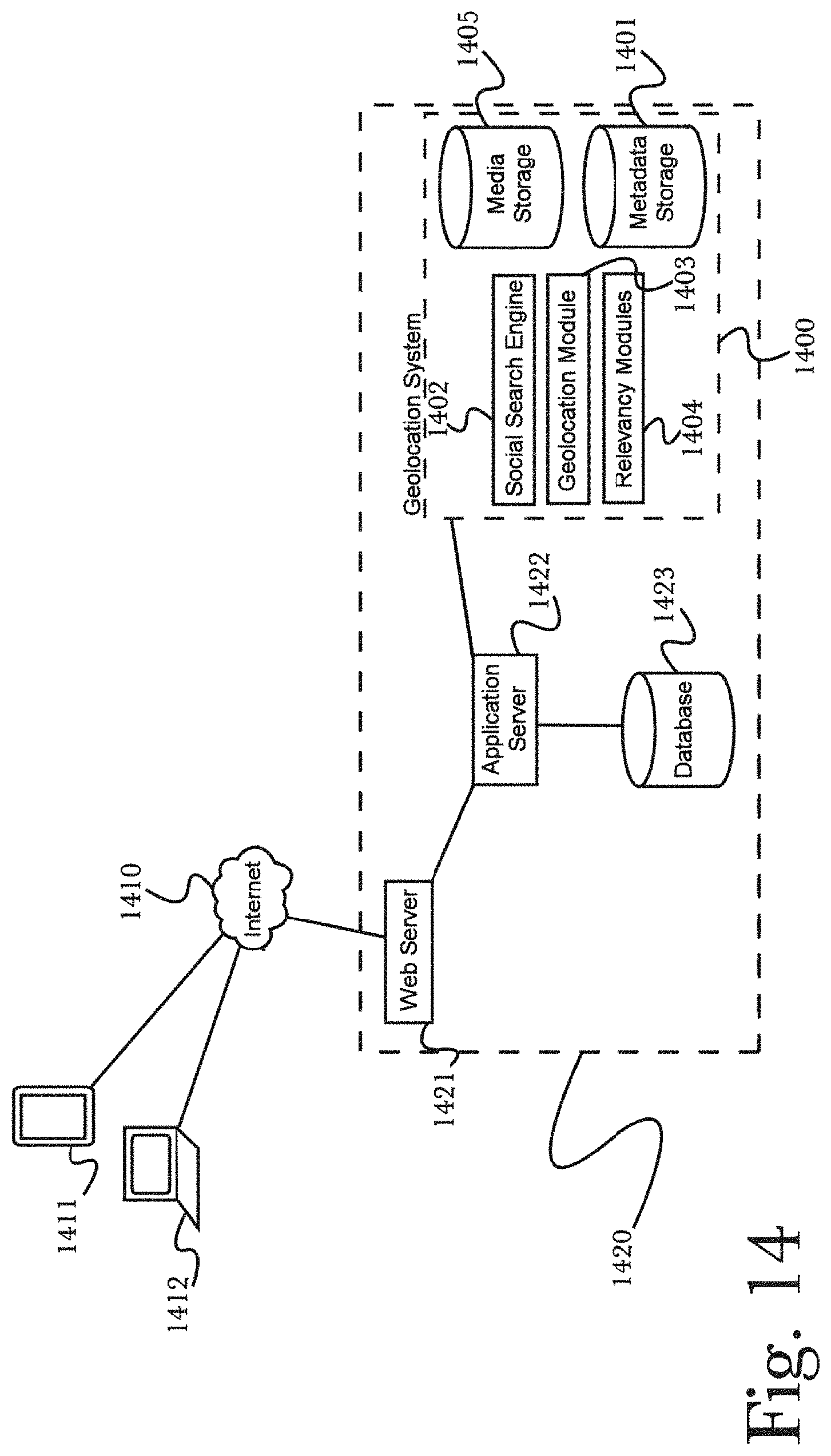
D00015
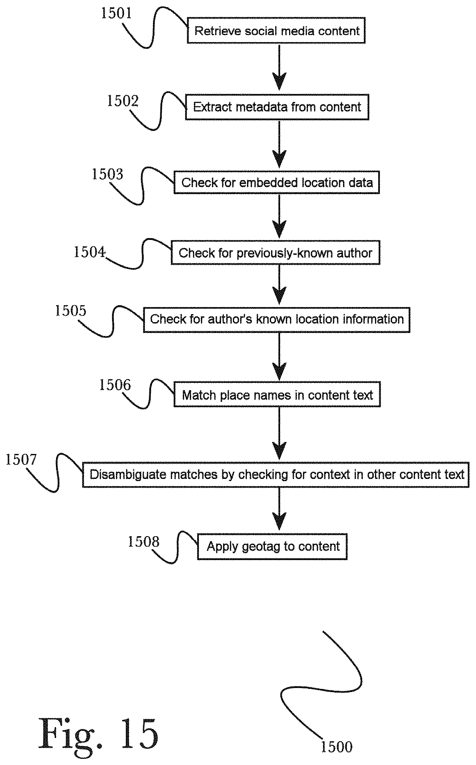
XML
uspto.report is an independent third-party trademark research tool that is not affiliated, endorsed, or sponsored by the United States Patent and Trademark Office (USPTO) or any other governmental organization. The information provided by uspto.report is based on publicly available data at the time of writing and is intended for informational purposes only.
While we strive to provide accurate and up-to-date information, we do not guarantee the accuracy, completeness, reliability, or suitability of the information displayed on this site. The use of this site is at your own risk. Any reliance you place on such information is therefore strictly at your own risk.
All official trademark data, including owner information, should be verified by visiting the official USPTO website at www.uspto.gov. This site is not intended to replace professional legal advice and should not be used as a substitute for consulting with a legal professional who is knowledgeable about trademark law.