Method and apparatus for epidemic and pandemic risk assessment
Frieder , et al. May 25, 2
U.S. patent number 11,013,472 [Application Number 17/130,639] was granted by the patent office on 2021-05-25 for method and apparatus for epidemic and pandemic risk assessment. This patent grant is currently assigned to AURA HOME, INC.. The grantee listed for this patent is AURA HOME, INC.. Invention is credited to Abdur Chowdhury, Ophir Frieder, Eric Jensen.


| United States Patent | 11,013,472 |
| Frieder , et al. | May 25, 2021 |
Method and apparatus for epidemic and pandemic risk assessment
Abstract
A method, system, and/or apparatus for automatically monitoring for possible infection or other physical health concerns, such as from Covid-19. The method or implementing software application uses or relies upon location information available on the mobile device from any source, such as cell phone usage and/or other device applications. The method and system automatically uses and/or learns user location and activity patterns and determines and infection risk that can be communicated as a warning to community members.
| Inventors: | Frieder; Ophir (Chevy Chase, MD), Chowdhury; Abdur (San Francisco, CA), Jensen; Eric (Brooklyn, NY) | ||||||||||
|---|---|---|---|---|---|---|---|---|---|---|---|
| Applicant: |
|
||||||||||
| Assignee: | AURA HOME, INC. (San Francisco,
CA) |
||||||||||
| Family ID: | 1000005360772 | ||||||||||
| Appl. No.: | 17/130,639 | ||||||||||
| Filed: | December 22, 2020 |
Related U.S. Patent Documents
| Application Number | Filing Date | Patent Number | Issue Date | ||
|---|---|---|---|---|---|
| 17038064 | Sep 30, 2020 | 10945680 | |||
| 16432373 | Jun 5, 2019 | 10813599 | |||
| 16046590 | Jul 26, 2018 | 10314550 | |||
| 15291819 | Oct 12, 2016 | 10039504 | |||
| 14848881 | Sep 9, 2015 | 9498163 | |||
| 14751399 | Jun 26, 2015 | 9439038 | |||
| 14270534 | May 6, 2014 | 9288616 | |||
| 14455279 | Aug 8, 2014 | 9386052 | |||
| 14455297 | Aug 8, 2014 | 9420015 | |||
| 14051071 | Oct 10, 2013 | 9225789 | |||
| 14051089 | Oct 10, 2013 | 9338759 | |||
| 14051071 | Oct 10, 2013 | 9225789 | |||
| 14051089 | Oct 10, 2013 | 9338759 | |||
| 14051071 | Oct 10, 2013 | 9225789 | |||
| 14051089 | Oct 10, 2013 | 9338759 | |||
| Current U.S. Class: | 1/1 |
| Current CPC Class: | A61B 5/746 (20130101); H04L 51/38 (20130101); G16H 40/63 (20180101); A61B 5/72 (20130101); A61B 5/1118 (20130101); A61B 5/7246 (20130101); A61B 5/7282 (20130101); A61B 5/7465 (20130101); A61B 5/742 (20130101); H04W 4/029 (20180201); H04W 4/33 (20180201); A61B 5/7267 (20130101); H04W 4/12 (20130101); A61B 5/1123 (20130101); H04L 67/22 (20130101); G06F 21/552 (20130101); H04L 51/20 (20130101); H04W 52/0254 (20130101); A61B 5/4866 (20130101); G06F 16/9535 (20190101); A61B 5/1112 (20130101); H04W 52/0229 (20130101); H04L 51/32 (20130101); G16Z 99/00 (20190201); H04W 4/023 (20130101); A61B 5/7455 (20130101); H04W 4/21 (20180201); A61B 5/6898 (20130101); G06F 2221/2111 (20130101); H04L 51/08 (20130101); Y02D 30/70 (20200801); H04W 64/006 (20130101); H04M 1/72454 (20210101) |
| Current International Class: | A61B 5/00 (20060101); H04W 4/21 (20180101); H04W 4/029 (20180101); G16Z 99/00 (20190101); H04W 4/33 (20180101); H04L 29/08 (20060101); A61B 5/11 (20060101); G06F 16/9535 (20190101); G06F 21/55 (20130101); H04L 12/58 (20060101); H04W 4/02 (20180101); H04W 4/12 (20090101); H04W 52/02 (20090101); G16H 40/63 (20180101); H04W 64/00 (20090101); H04M 1/72454 (20210101) |
References Cited [Referenced By]
U.S. Patent Documents
| 8633853 | January 2014 | Amidi |
| 9225789 | December 2015 | Jensen et al. |
| 9288616 | March 2016 | Cherry et al. |
| 9338759 | May 2016 | Chowdhury et al. |
| 10902955 | January 2021 | Federoff |
| 2007/0282621 | December 2007 | Altman et al. |
| 2008/0201638 | August 2008 | Nair |
| 2009/0240586 | September 2009 | Ramer et al. |
| 2009/0286549 | November 2009 | Canon |
| 2009/0316671 | December 2009 | Rolf et al. |
| 2010/0030612 | February 2010 | Kim et al. |
| 2010/0082398 | April 2010 | Davis et al. |
| 2010/0130233 | May 2010 | Parker |
| 2010/0280904 | November 2010 | Ahuja |
| 2010/0298899 | November 2010 | Donnelly et al. |
| 2010/0332324 | December 2010 | Khosravy et al. |
| 2010/0332326 | December 2010 | Ishai |
| 2011/0029359 | February 2011 | Roeding et al. |
| 2011/0029370 | February 2011 | Roeding et al. |
| 2011/0161427 | June 2011 | Fortin et al. |
| 2011/0178863 | July 2011 | Daigle |
| 2011/0179064 | July 2011 | Russo |
| 2011/0238755 | September 2011 | Khan et al. |
| 2012/0047129 | February 2012 | Redstone |
| 2012/0058782 | March 2012 | Li |
| 2012/0089679 | April 2012 | Gold |
| 2012/0158845 | June 2012 | Baalu et al. |
| 2012/0179563 | July 2012 | Soroca et al. |
| 2012/0215637 | August 2012 | Hermann |
| 2012/0265841 | October 2012 | Ross et al. |
| 2012/0270611 | October 2012 | Choi |
| 2012/0278387 | November 2012 | Garcia et al. |
| 2012/0290389 | November 2012 | Greenough et al. |
| 2012/0302258 | November 2012 | Pai et al. |
| 2012/0309376 | December 2012 | Huang |
| 2012/0316963 | December 2012 | Moshfeghi |
| 2013/0060640 | March 2013 | Gadhia et al. |
| 2013/0066964 | March 2013 | Odio et al. |
| 2013/0073622 | March 2013 | Nguyen et al. |
| 2013/0085861 | April 2013 | Dunlap |
| 2013/0103757 | April 2013 | Mitchell et al. |
| 2013/0117109 | May 2013 | Busch |
| 2013/0166386 | June 2013 | Simmons |
| 2013/0191215 | July 2013 | Metcalf |
| 2013/0203440 | August 2013 | Bilange et al. |
| 2013/0303106 | November 2013 | Martin |
| 2014/0081667 | March 2014 | Joao |
| 2014/0333432 | November 2014 | Armitage |
| 2014/0365507 | December 2014 | Wissner et al. |
| 2015/0058345 | February 2015 | Mishra et al. |
| 2015/0074721 | March 2015 | Fishman et al. |
| 2015/0106448 | April 2015 | Ownbey et al. |
| 2015/0106449 | April 2015 | Cherry et al. |
| 2015/0373493 | December 2015 | Chowdhury et al. |
| 2016/0066864 | March 2016 | Frieder et al. |
| 2016/0128618 | May 2016 | Lee |
| 2016/0140934 | May 2016 | Frieder et al. |
| 2016/0196389 | July 2016 | Moturu et al. |
| 2017/0027529 | February 2017 | Frieder et al. |
| 2017/0188196 | June 2017 | Shen et al. |
| 2017/0286613 | October 2017 | Bender |
| 2018/0333108 | November 2018 | Frieder et al. |
| 2019/0343467 | November 2019 | Frieder et al. |
Other References
|
Hazas, M., et al., "Location-Aware Computing Comes of Age," Invisible Computing, Feb. 2004, pp. 95-97. cited by applicant . Chen, G., et al., "A Survey of Context-Aware Mobile Computing Research," Dartmouth Computer Science Technical Report TR2000-381, (2000), 16 pages. cited by applicant . Bahl, P., et al., "Radar: An In-Building RF-based User Location and Tracking System," IEEE InfoCom (2000), vol. 2, pp. 775-784. cited by applicant . Kennedy, M., et al., "Adaptive Energy Optimization in Multimedia-centric Wireless Devices: A Survey," IEEE Communication Surveys and Tutorials (COMST), (2012), 19 pages. cited by applicant . Wang, C., et al., "Simultaneous Localization, Mapping and Moving Object Tracking," International Journal of Robotics Research (2004), 47 pages. cited by applicant . Krumm, J., et al., "Locadio: Inferring Motion and Location from Wi-Fi Signal Strengths," Mobiquitous Conference, Boston, MA, Aug. 22-26, 2004, pp. 4-13. cited by applicant . Perrucci, G. P., et al., "On the Impact of 2G and 3G Network Usage for Mobile Phones' Battery Life," European Wireless Conference (2009), May 17-20, pp. 255-259. cited by applicant. |
Primary Examiner: Keller; Michael A
Attorney, Agent or Firm: Pauley Erickson & Swanson
Parent Case Text
CROSS REFERENCE TO RELATED APPLICATIONS
This application is a continuation-in-part of Ser. No. 17/038,064, filed on 30 Sep. 2020, which is a continuation of U.S. patent application Ser. No. 16/432,373, filed on 5 Jun. 2019, which is a continuation of U.S. patent application Ser. No. 16/046,590, filed on 26 Jul. 2018, which is a continuation of U.S. patent application Ser. No. 15/291,819, filed 12 Oct. 2016, which is a continuation of U.S. patent application Ser. No. 14/848,881, filed 9 Sep. 2015, which is a continuation-in-part of U.S. patent application Ser. No. 14/751,399, filed 26 Jun. 2015, which is a continuation-in-part of each of: U.S. patent application Ser. No. 14/270,534, filed 6 May 2014, U.S. patent application Ser. No. 14/455,279, filed 8 Aug. 2014, and U.S. patent application Ser. No. 14/455,297, filed 8 Aug. 2014; each of which is a continuation-in-part of each of U.S. patent application Ser. No. 14/051,071, filed on 10 Oct. 2013, and U.S. patent application Ser. No. 14/051,089, filed on 10 Oct. 2013. The co-pending parent applications are hereby incorporated by reference herein in their entirety and are made a part hereof, including but not limited to those portions which specifically appear hereinafter.
Claims
What is claimed is:
1. A method of determining infection risks for individuals during an epidemic or pandemic, such as Covid-19, the method executed by a computer system and comprising: automatically determining positional destinations of a user using a first mobile electronic device of the user; automatically monitoring the positional destinations and user activities performed at the positional destinations of the user via the first mobile electronic device; receiving user information comprising a user activity performed at each of the positional destinations upon the user arriving at the each of the positional destinations; automatically learning activity patterns for the user activity by automatically associating the user information with the each of the positional destinations, automatically determining a user activity context for the user activity, and automatically comparing a further context of each of a plurality of further user arrivals to the each of the positional destinations to the user activity context, wherein the activity patterns comprise an eating pattern or an exercise pattern, at a location or with one or more community members; automatically determining context information about the each of the positional destinations without input by the user; automatically updating context information associated with the each of the positional destinations from the further context of each of the further user arrivals; automatically deducing as user information a location type and/or user activity of the each of the positional destinations from the context information; automatically identifying that the first user is participating in the user activity upon future user arrivals at the each of the positional destinations as a function of comparing the context information to a future context of each of the future user arrivals, without receiving any manually entered confirmation or manually entered additional user information; assigning a user risk assessment to the user according to locations and/or activities of the user during a predetermined timeframe, wherein the predetermined timeframe is at least a predetermined incubation or latency period of a contagion or pathogen; and providing the user risk assessment to a community member via a community member electronic device before an in-person meeting with the user, wherein the user risk assessment is automatically displayed to the community member upon an electronic meeting request and/or the in-person meeting being entered into an electronic calendar.
2. The method of claim 1, wherein the user risk assessment is a compilation of a plurality of risk metrics determined for the locations and/or activities during the predetermined time period.
3. The method of claim 1, further comprising: determining a risk metric for each of the locations and/or activities for the user, to provide a plurality of risk metrics during the predetermined timeframe; and computing the user risk assessment from the plurality of risk metrics.
4. The method of claim 3, wherein the risk metric is determined from a predetermined assessment score for each of the location and any activity performed at the location, as a function of time at the location and/or performing the activity.
5. The method of claim 3, further comprising: determining a corresponding user participation time for the each of the locations and/or activities; and scaling the risk metric for the each of the locations and/or activities according to the corresponding user participation time.
6. The method of claim 3, wherein the determining the risk metric for the each of the locations and/or activities comprises comparing a location and/or an activity to a predetermined risk scale.
7. The method of claim 3, further comprising increasing a risk metric of the user risk assessment upon an in-person contact at the locations and/or activities with a person having a negative risk assessment.
8. The method of claim 1, further comprising: determining any in-person contact of the user for the each of the locations and/or activities; obtaining a contact person risk assessment for the in-person contact; and adjusting the user risk assessment as a function of the contact person risk assessment.
9. The method of claim 1, further comprising: automatically associating the user with a second user at one or more of the positional destinations, wherein a second user location and/or second user activity is determined; automatically inferring the location type and/or user activity from the second user location and/or activity; and adjusting the user risk assessment due to in-person contact with the second user.
10. The method of claim 1, further comprising for each of the locations, determining an assessment score by normalizing a number of infected people in an area around each of the locations.
11. The method of claim 1, wherein the user risk assessment is a summation of a risk metric for each of a location, an activity, and a duration of the activity and/or at the location.
12. The method of claim 1, wherein the computer system comprises the first user electronic device in wireless communication with a server computer, and the computer system comprises more than one non-transitory recordable medium collectively including a series of preprogrammed instructions that, when executed by the first user electronic device and the server computer, cause the computer system to perform the method.
13. The method of claim 1, wherein the user risk assessment is a compilation of a plurality of risk metrics determined for the locations and/or activities during the predetermined time period, and each of the risk metrics is determined from a predetermined assessment score for each of the location and any activity performed at the location, as a function of time at the location and/or performing the activity.
14. The method of claim 13, further comprising: determining a risk metric for each of the locations and/or activities for the user, to provide the plurality of risk metrics during the predetermined timeframe, wherein the determining the risk metric for the each of the locations and/or activities comprises comparing a location and/or an activity to a predetermined risk scale; determining a corresponding user participation time for the each of the locations and/or activities; scaling the risk metric for the each of the locations and/or activities according to the corresponding user participation time; increasing any risk metric of the user risk assessment upon an in-person contact at the each of the locations and/or activities with a person having a negative risk assessment; and computing the user risk assessment from the plurality of risk metrics.
15. The method of claim 1, further comprising: automatically determining a first user visit of a user at a first positional destination via a first user electronic device; automatically determining a location of the first positional destination via the first mobile electronic device; receiving a first user activity at the location through the first mobile electronic device; automatically determining a first context for the first user visit and the first user activity; automatically tagging the location with the first user activity and the context information determined from the first context, and storing the tagged location in a location database; automatically determining a second user visit at the first positional destination via the first user electronic device; automatically delivering via the first user electronic device a request for manual confirmation of the first user activity being performed for the second user visit; automatically determining a second context for the second user visit at the positional destination; automatically updating the context information of the tagged location from the second context; for each of a plurality of automatically determined further user visits at the positional destination, automatically determining a potential for the first user activity based upon a comparison of a corresponding further context automatically determined for the each of the further user visits to the context information; automatically presenting the first user activity to the first user through the first user electronic device for manual confirmation of the first user activity through the user device at each of a plurality of further user visits at the location; automatically updating the context information of the tagged location from the further context of each of the further user visits; automatically learning the user activity by automatically associating the first user activity with the location and the context information after receiving the first user activity for the plurality of further user visits at the location; automatically deducing that the first user is participating in the learned user activity upon future user arrivals at the location as a function of comparing the context information to a future context of each of the future user arrivals, without receiving any manually entered confirmation or manually entered additional user information.
16. The method of claim 15, wherein the user risk assessment is a compilation of a plurality of risk metrics determined for the locations and/or activities during the predetermined time period, and each of the risk metrics is determined from a predetermined assessment score for each of the location and any activity performed at the location, as a function of time at the location and/or performing the activity, and further comprising: determining a risk metric for each of locations and/or activities for the user, to provide the plurality of risk metrics during the predetermined timeframe, wherein the determining the risk metric for the each of the locations and/or activities comprises comparing a location type and/or an activity to a predetermined risk scale; determining a corresponding user participation time for the each of the locations and/or activities; scaling the risk metric for the each of the locations and/or activities according to the corresponding user participation time; increasing any risk metric of the user risk assessment upon an in-person contact at the each of the locations and/or activities with a person having a negative risk assessment; and computing the user risk assessment from the plurality of risk metrics.
Description
FIELD OF THE INVENTION
This invention relates generally to automated health monitoring, and more particularly, to a method, system, and apparatus that automatically determines infection risk, such as during the current Covid-19 pandemic.
BACKGROUND OF THE INVENTION
The current Covid-19 pandemic has magnified a need for monitoring methods. Contract tracing relies on a person to self-identify as infected, and suffers from concerns of information leaks. Testing and treatment can be difficult due to shortages, delays, etc.
Prevention is better than treatment. There is a need for passive monitoring based systems and methods that indicate likelihood of viral and/or bacterial exposure, such as due to contact with a specific individual.
Social media systems have permeated daily life. Information is collected, organized, and disseminated worldwide via informational collection and dissemination, micro-blogging and blogging services. Other social media are mobile and positional in nature and can be referred to as Mobile Positional Social Media (MPSM). As these systems focus on locations, mobile device implementations permeate the space. That said, however, while MPSM implementations are targeted to primarily execute on mobile devices, such as but not limited to smart-phones (e.g., Apple's iPhone, Google's Android), tablets (e.g., Apple's iPad, HP TouchPad), and laptop computers, they often support implementations for non-mobile environments such as but not limited to desktops and workstations, and large scale compute farms and cloud computing servers.
One limitation of MPSM systems is their reliance on global positioning systems (GPS). The use of GPS devices does typically simplify location tracking implementation; however, this comes at a significant energy cost. Since a significant portion of MPSM systems usage is via mobile devices, reducing energy consumption is critical.
Another limitation of current MPSM systems, similar to contact tracing, is their reliance on active users identifying their location and/or their activity at the location. Another limitation of current MPSM systems is the limited modes of informational guidance provided to the user. For example, no reminders or instructional commenting is provided. That is, users are not reminded of activities that fit their given location and context in a push manner; rather, user inquiry of locally available options is needed. Ideally, given location and context users are proactively pushed information that is immediately relevant to them. Additionally, activities that are nearby to their current location or will become available can likewise be identified.
The use of smartphone technology for medical applications is increasing. In August 2014, the Food and Drug Administration (FDA) cleared a smartphone device, AliveCor, that detects atrial fibrillation, a potential warning sign for heart failure and stroke. Additionally, Apple Corporation, in support of medical smartphone technology, recently developed an open-source tool kit to aid in the authoring of medical research applications. Also known in the art is the use of activity and trend detection using smartphone technology for medical applications. Recently, an Android based application called StudentLife was introduced at Dartmouth College. This application monitors smartphone use (e.g., text messaging, e-mail traffic, etc.) as well as additional activity (e.g., mobility and sleep patterns) to infer state of being. Automatic sensed, as well as interactive user probing, data were collected to determine potential stress.
There is thus a continuing need for and interest in improved mobile device-based systems and applications for medical applications, and particularly for infectious disease control and monitoring.
SUMMARY OF THE INVENTION
This invention provides a method, system, and apparatus, such as embodied in a MPSM or other software application that automatically determines infection risks for individuals during an epidemic or pandemic, such as Covid-19. The method and system of this invention monitor, such as via mobile devices, locations, activities, and/or in-person contacts for users of the invention. This information is then used to determine and assign a risk assessment to the user, which can be used by others, including family, friends, and even employers or other third parties to make decisions on whether to have contact with the users. The invention can conceal the specific activities, thereby avoiding privacy issues, but still give a general risk warning indication, such as low-high, or a numerical or color version thereof.
In embodiments of this invention, the risk assessment is obtained mathematically by allocating a predetermined value to various locations and activities. For example, the method and system can use current infection information for a region (e.g., state, county, city, etc.) to set a risk metric for a location within that region. Likewise, particularly for the Covid-19 pandemic, government and healthcare agencies have provided typical locations (e.g., bars) and activities (e.g., eating indoors at restaurants) with warning scales, where higher risk activities are ones that are more likely to result in an exposure to the SARS-CoV-2 virus. Similarly, in-person contact with others can be used to further scale the risk assessment, even including consideration of a calculated risk assessment of the in-person contact if known.
The invention operates on information obtained about a user's travels and activities. This information can be determined using any known monitoring method, such as mobile phone tracking. In embodiments of this invention, the method and system can automatically monitor and determine locations and/or activities of a user, thereby learning activity patterns for the user. The application learns user activity over time, with the learning based upon user locations and/or context. The present invention generally provides and uses methods and applications for a MPSM that automatically understands and informs the "who, what, when, where, and/or how" of a user and the user's community. For example, who are the user and their community with, what are the user and their community doing, where geographically are the user and their community, when are, and historically when were, the user and their community doing this? While the location and activity learning can be on-going, the risk assessment can be determined for a particular timeframe of interest, such as a predetermined incubation or latency period of a contagion or pathogen (e.g., two weeks before a scheduled meeting).
Embodiments of this invention include a method of determining infection risks for individuals during an epidemic or pandemic, such as Covid-19. The method is executed by a computer system and includes steps of: automatically determining positional destinations of a user using a first mobile electronic device of the user; automatically determining context information about each of the positional destinations without input by the user; automatically deducing as user information a location type and/or user activity of each of the positional destinations from the context information; assigning a user risk assessment to the user according to locations and/or activities of the user during a predetermined timeframe; and providing the user risk assessment to a community member, such as before an in-person meeting, via a community member electronic device.
The predetermined timeframe can be determined from or by a predetermined incubation or latency period of a contagion or pathogen. For example, the predetermined period can be a two-week period for possible SARS-CoV-2 infection. The period can be determined, and adjusted, depending on need, and any particular pathogen.
The invention further includes a method of determining infection risks for individuals during an epidemic or pandemic, such as Covid-19, including steps of: automatically monitoring destinations and user activities performed at the destinations of a first user via a first electronic device of the first user; receiving user information comprising a first user activity performed at each of the destinations upon a user arriving at the each of the destinations; automatically learning activity patterns for the first user activity by automatically associating the user information with the at least one of the destinations, automatically determining a user activity context for the first user activity, and automatically comparing a further context of each of a plurality of further user arrivals to the at least one of the destinations to the user activity context, wherein the activity patterns comprise an eating pattern or an exercise pattern, at a location or with one or more community members; automatically updating context information associated with the at least one destination from the further context of each of the further user arrivals; automatically identifying that the first user is participating in the first user activity upon future user arrivals at the at least one destination as a function of comparing the context information to a future context of each of the future user arrivals, without receiving any manually entered confirmation or manually entered additional user information; assigning a user risk assessment to the user according to locations and/or activities of the user during a predetermined timeframe, wherein the predetermined timeframe is at least a predetermined incubation or latency period of a contagion or pathogen; and providing the user risk assessment to a community member via a community member electronic device before an in-person meeting with the user.
The user risk assessment can be a compilation of a plurality of risk metrics determined for the locations and/or activities during the predetermined time period, and each of the risk metrics is determined from a predetermined assessment score for each of the location and any activity performed at the location, as a function of time at the location and/or performing the activity. The invention can include, for example, steps of: determining a risk metric for each of the locations and/or activities for the user, to provide the plurality of risk metrics during the predetermined timeframe, wherein the determining the risk metric for the each of the locations and/or activities comprises comparing a location and/or an activity to a predetermined risk scale; determining a corresponding user participation time for the each of the locations and/or activities; scaling the risk metric for the each of the locations and/or activities according to the corresponding user participation time; increasing any risk metric of the user risk assessment upon an in-person contact at the each of the locations and/or activities with a person having a negative (e.g., high or otherwise undesirable) risk assessment; and computing the user risk assessment from the plurality of risk metrics. As used herein, a "negative" risk assessment generally refers to a greater chance of being infected, based upon methods and scales according to this invention.
The invention further includes a method of determining infection risks for individuals during an epidemic or pandemic, such as Covid-19, including steps of: automatically determining a first user visit of a user at a positional destination via a first user electronic device; automatically determining a location of the positional destination via the first user electronic device; receiving a user activity at the location through the first user electronic device; automatically determining a first context for the first user visit and user activity; automatically tagging the location with the user activity and context information from the first context, and storing the tagged location in a location database; automatically determining a second user visit at the positional destination via the first user electronic device; automatically delivering via the first user electronic device a request for manual confirmation of the user activity being performed for the second user visit; automatically determining a second context for the second user visit at the positional destination; automatically updating the context information of the tagged location from the second context; for each of a plurality of automatically determined further user visits at the positional destination, automatically determining a potential for the user activity based upon a comparison of a corresponding further context automatically determined for the each of the further user visits to the context information; automatically presenting the user activity to the first user through the first user electronic device for manual confirmation of the user activity through the user device at each of a plurality of further user visits at the location; automatically updating the context information of the tagged location from the further context of each of the further user visits; automatically learning the user activity by automatically associating the user activity with the location and the context information after receiving the user activity for the plurality of further user visits at the location; automatically deducing that the first user is participating in the learned user activity upon future user arrivals at the location as a function of comparing the context information to a future context of each of the future user arrivals, without receiving any manually entered confirmation or manually entered additional user information; assigning a user risk assessment to the user according to the locations and/or activities of the user in a predetermined timeframe; and providing the user risk assessment to a community member via a community member electronic device.
In embodiments of this invention, the automatic monitoring of destinations and user activities of a first user via a first electronic device of the first user includes: automatically determining a corresponding context for each of the user activities at a first user visit to each of the destinations; automatically tagging each of the destinations with a corresponding one of the user activities and corresponding context information, and storing the tagged location in a location database; automatically updating the context information of the tagged location for each of a plurality of automatically determined further user visits at the destinations from the further context of each of the further user visits; and automatically associating the first user activity with corresponding destinations and the corresponding context information. Each of the first context, the second context, the further context, and the context information can include at least one of: a time of day, a day of a week, a calendar date, a preceding user activity to the user visits, a weather condition, people accompanying the user, or community member activity bias information for the destination.
The invention includes a method of automated learning location and activity patterns for a user and automated determination of medical concerns, such as through a social networking service. The method is executed by a software application stored and executed on one or more computers or data processor systems, such as a mobile device (e.g., phone, tablet, or laptop) and/or an application server (such as for connecting user communities). In one embodiment the method includes receiving user information about a destination, automatically associating the user information with the destination, learning activity patterns for a user, automatically sharing the user information in the social networking service upon further user arrivals at the destination prior to receiving any additional user information.
The invention also includes a method and supporting system for determining potentially unhealthy or dangerous activity risks by users participating in a social networking service. The method is executed by a computer system and includes steps of: automatically and either periodically or continually tracking locations of member electronic devices of a plurality of members of a social media community of a first user; automatically displaying location information for each of the plurality of members on a first user electronic device; and automatically determining and communicating an increased risk of infection through a respective user electronic device.
In embodiments of this invention, the system or application identifies locations, and over time, automatically "checks-in" not only the locations but what the locations imply in terms of potential activities of the user. That is, given a location and a user, the system desirably suggests what activity or activities the user typically partakes at that location. For example, if a user frequents a location in "Potomac," this location might be identified as "parents' home." Furthermore, at this home, a variety of activities might be common such as: "visiting parents," "drinking tea," "eating lunch," or "sampling wine." In embodiments of this invention, each time the user appears at that location, based on context, defined by elements of or surrounding the activity such as but not limited to time of day, day of week, immediately preceding activities, weather, surrounding people, etc., a set of likely occurring activities are identified. The user can be prompted with a list from which to select a subset of these activities or to identify a new activity. The invention can also include ranking a user's potential suggested activity based on context and presenting that ranked list to the user, or the user's community. The invention generally provides a learning component that can allow the manual inputs to become automatic prompts, which can become automatically issued notifications for the location based upon the context. The prompts can be issued through any known format, such as an application alert on the device or a text message to the user. The invention also supports the user changing activities for a given location at any time, and/or user implemented delay of the notification of a user's location or activity.
The invention can include the incorporation or creation of user communities and sub-communities, with such communities and sub-communities sharing information. Embodiments of the invention include automatically identifying a user's location and activity, and desirably notifying that user's community of that user's location. Particular embodiments of this invention provide one or more additional community functionalities including, without limitation, automatically identifying a user's activity and notifying that user's community of that user's activity, commenting on user activity and location report by user or community--with multiple and multimedia comments supported, supporting the "liking" of user activity by the community, supporting the user tagging of location, activity, or the pairing of location and identity--tagging can be textual or via any multimedia means, correlating the individual user's activity with the ongoing activity of others within the community, and/or correlating the individual user's activity with the past activities of others within the community.
One embodiment of this invention provides a method of and system for automated determining of locations and/or activities of a user participating in a social networking service. The method is executed by a MPSM computer system and automatically determines a positional destination of a user, automatically deduces as user information a location type and/or user activity of the positional destination, and automatically shares the user information as instructed in the social networking service. Deducing the user information is based upon context information about the positional destination, desirably with minimal or no input by the user. The context can include, without limitation, time-dependent information, past and/or current associated user information, past user and/or community information about the location, and/or third party information. The context can be used to at least reduce location types and/or user activities, for example, as a function of the past location type and/or user activity of the positional destination for a given time period.
Another limitation of current MPSM systems is their lack of individual and community activity summarization capability. That is, summary of the local user and community member activities and time durations are not available, neither to the local user nor to their community. This summarization can range from simple statistical aggregation to advanced correlations as derived by known techniques in the art. In embodiments of this invention, users are provided with summaries of their locations, durations at these locations, and activities at these locations. Furthermore, at the discretion of the local user, these summaries are made available to their community members. Particular embodiments of this invention provide one or more additional summarization functionalities including, without limitation, maintaining a history of user locations, activities, or combination thereof, correlating the individual user's activity with the past activities of the user, correlating the individual user's activity with the expected learned future activities of self, data mining behavioral patterns and suggesting alternatives to avoid obstacles, providing statistical aggregation of locations visited, providing derived summarization of locations visited, providing statistical aggregation of activities, providing derived summarization of activities, providing statistical aggregation and/or derived summarization of individuals (such as community members) encountered during a time period.
Other objects and advantages will be apparent to those skilled in the art from the following detailed description taken in conjunction with the appended claims and drawings.
BRIEF DESCRIPTION OF THE DRAWINGS
FIG. 1 shows a representative area of a user of one embodiment of this invention.
FIG. 2 illustrates geofences surrounding a current reading and its immediate neighbors according to one embodiment of this invention.
FIG. 3 illustrates the determination of a location via intersecting circles according to one embodiment of this invention.
FIG. 4 illustrates the processing flow employed to identify an arrival according to one embodiment of this invention.
FIG. 5 illustrates example Covid-19 cases for all 23 Maryland counties and the City of Baltimore.
FIG. 6 shows exemplary Covid-19 risk assessment scores for activity types.
FIG. 7 shows database records of locations, durations, and types of activity for community members under consideration in a provided example.
FIG. 8 illustrates smartphone and fitness tracker or other biosensor device interaction according to one embodiment of this invention.
DETAILED DESCRIPTION OF THE INVENTION
This invention provides a method, system, and apparatus, such as embodied in a MPSM or other software application that automatically determines infection risks for individuals during an epidemic or pandemic, such as Covid-19. The method and system of this invention monitor, such as via mobile devices, locations, activities, and/or in-person contacts for users of the invention. This information is then used to determine and assign a risk assessment to the user, which can be used by others, including family, friends, and even employers or other third parties to make decisions on whether to have contact with this user. The MPSM technology and method of this invention can also be paired with other electronic monitoring systems, such as electronic pulse, body temperature, or other fitness related monitors, particularly wearable devices, via wireless communication.
The automatic and continual determination of locations and/or activities of users participating in a social networking service allows for learning behavior patterns, and more particularly activity patterns, such as location visits, activities performed at the locations, and any community presence at those activities. As a brief example, upon repeated Friday morning tennis at the club with John, the system learns that the user is playing tennis on Friday mornings if the system detects that the user is at the club and/or the user is with John. The invention merges this technology with health care monitoring, by using the learned patterns to analyze and detect risk assessments for infection. Using the example above, if the user unwisely continues these activities against health expert advice during an epidemic or pandemic, then the user's risk of infection is increased and can be quantified and reported by this invention, even without specifically saying John played tennis. The user's risk assessment can be automatically provided to a community member (e.g., family member, friend, employer, etc.) via a community member electronic device.
Embodiments of this invention warn of potential viral and/or bacterial exposure due to contact with a specific community member. Such warnings aid in combating spread during epidemic and pandemic outbreaks such as, but not limited to, Covid-19. As disclosed, the invention passively records, for each community member, locations resided or visited, duration at the given locations, and activities involved at each location. Note that it is also within the scope of the invention to record only selected activities, namely recording only those activities and locations of interest. Using this information, embodiments of this invention determine a categorical degree of risk of infection, for example, low, medium and high, that visiting locations, performing activities, and/or physically interacting with a particular community member poses based on that member's prior geographical presence and behavioral patterns.
As such, the invention relies on automatically determined and/or learned location and activity patterns of an individual and her/his community members to determine infection or illness risk. In embodiments of this invention, the user's risk assessment is a compilation of a plurality of risk metrics determined for the locations and/or activities using a mobile device or other information, during a predetermined time period. A risk metric is determined for each of the locations and/or activities for the user, to provide a plurality of risk metrics during the predetermined timeframe for the computation.
In embodiments of this invention, the application learns user activity over time, with the learning based upon user locations and/or context. The application can learn through automatically determining activities at locations based upon known context information and past context information for the location. The invention further includes energy saving location methods for the mobile device that can be used to more efficiently allow the location and social media aspects of the invention to be implemented on a mobile device. The method and application can be used for any suitable function, such as a safety and/or reminder serves, and is particularly useful for use in social media applications. The invention will be described below with implementation in a MPSM system, and particularly with an MPSM application that learns user activity over time, with the learning based upon user locations and/or context.
The method and system of this invention is mobile and positional in nature. Such systems, like many other systems originally developed on one type of computing platform but migrated to another, operate not only on mobile environments. That is, while MPSM implementations are targeted to primarily execute on mobile devices, such as but not limited to smart-phones, tablets, and/or laptops, they often support implementation for non-mobile environments such as but not limited to desktops and workstations, servers, and large scale compute farms and cloud computing servers. The invention will be described below with a mobile device, such as smart phone having cell service, a GPS system, and access to the Internet via WiFi.
The method and system of this invention is desirably executed or implemented on and/or through a mobile device computing platform. Such computing platforms generally include a processor, a recordable medium, an input/output (I/O) device, and a network interface capable of connecting either directly or indirectly to the Internet. The mobile device executes over a networked environment, a non-limiting example shown in FIG. 1. The mobile device is connected, either directly or indirectly, using any of the many techniques and technologies known in the art, over a network, to back-end system or systems, itself/themselves computing devices. The mobile device can connect with a remote server, shown in FIG. 1 as server 38, to store and/or access user or community information.
MPSM systems are used to support users remaining socially aware of their community. That is, their primary usage typically is to actively monitor the location and activity of family members, friends, colleagues, and generally others within one's community. Communities can be partitioned into sub-communities where the union of the sub-communities forms the user's community. The sub-communities may or may not overlap. The partitioning of communities into sub-communities is beneficial in supporting specialized applications. For example, while a user might have general interest in the location and activity of all of their community members, they might be particularly interested in the location and activity of those who might be suddenly in need of assistance.
Regardless of the community size, besides tracking users to potentially provide immediate assistance, medical environments that support state-of-being can capitalize on MPSM systems. State-of-being applications can detect abnormal patterns in a user's behavior or physical presence. By learning typical behavior of an individual regularly using a MPSM system according to embodiments of this invention, abnormality in behavior can be detected, and an alarm issued. It is within the scope of this invention to additionally incorporate data and information from health monitoring applications known in the art that are likewise resident on the mobile device to support state-of-being applications. Similarly, in community activities that require continuous monitoring and coordination, such as but not limited to an emergency response team or a neighborhood watch or other surveillance efforts, MPSM systems according to this invention can provide the necessary infrastructure to support the needed synchronization.
The creation of a community can include the issuing of invitations. An invitation is a request by a user A of another user B to allow the inviting user, user A, to track the activities of the invited user, user B, and vice versa. If the invited user accepts, the inviting and invited users form a community.
A community is relevant to only that user which formed it. That is, different users have different communities. A community is a grouping of invited (referred to as remote) users by the inviting (referred to as local) user. A local user can partition or merge a community, thus forming a sub-community or a parent community, respectively. For example, consider 5 users: Bob, Sam, Sally, Alice, and Susan. Bob can invite Sam, Sally, and Alice, thus forming his user community. Bob can likewise partition his community into a sub-community consisting of only Sam and Sally. Sally can invite Susan. Thus, Sally's community would include Bob (via his invitation) as well as Susan. If no additional invites occurred, Sam's and Alice's respective communities would only include Bob (each via Bob's invitation), while Susan's community would only include Sally (via Sally's invitation).
Providing users with the opportunity to expand their communities in a convenient manner is advantageous. Such expansion can seamlessly be accommodated by including users listed in a user's contact lists either as a whole or selectively into their community. Contact lists include, but are not limited to, users listed in a user's local address book, e-mail contact list, Twitter follow list, LinkedIn connections list, and/or Facebook friends list. By incorporating users listed in a user's contact list, the user's community is expanded without effort. Note, however, that selected inclusion can be supported; thus enabling community growth without unnecessarily over-expanding the community. That is, entries from the contact list can be included in their entirety and the user can selectively remove those entries which s/he wishes to be excluded from the community. Similarly, entries from the contact list can be selectively added.
Users are identified by their account identifier. To use MPSM a user account is created. User accounts generally require a user login, which is a unique user identifier, and a password or equivalent. After having created an account, a user can log in. Initially, the local user does not have a community. In embodiments of this invention, over time, the method and application tracks the activities and location of the local user. Should the local user establish a community as aforementioned described, the community members will likewise be tracked. Local users receive notifications of the location and activities of their community members. Once logged in, the local user can select to activate or deactivate self and community tracking and notification. If not overwritten, default settings are used.
Whenever logged in and tracking is enabled, a user's location and activity is tracked. That is, a user periodically records their location and/or activity. Locations are tagged by name. Names can be but are not limited to the following schemes: physical (e.g., 123 Oak St.), absolute (e.g., Acme Coffee), and/or relative (e.g., my work office), or proximity (e.g., two miles from home). Activities are typically events. These events might be common to the entire community such as: "drinking coffee," "eating lunch," "sampling wine," "working from home," "commuting," etc., to more specific to a local user such as "restoring car" or "driving to lake home." Multiple activities can occur simultaneously. Users can change their activities at any time.
Unless preloaded or derived from an external source, such as but not limited to a location database, initially, all locations and activities are unknown. Local users must record all such location-activity combinations, i.e., a local user must name or tag the location and the associated activity. A list of activities common to the local user's community can be provided. This community activity list can be ranked either arbitrarily (randomly), according to most recently used, most frequently used, relevance to location, alphabetically, etc. Eventually, an activity list specific to the local user is learned. This local user activity list can be displayed to the local user either individually, along with the community list, or merged with the community list. Again, any of these lists can be ranked as previously mentioned.
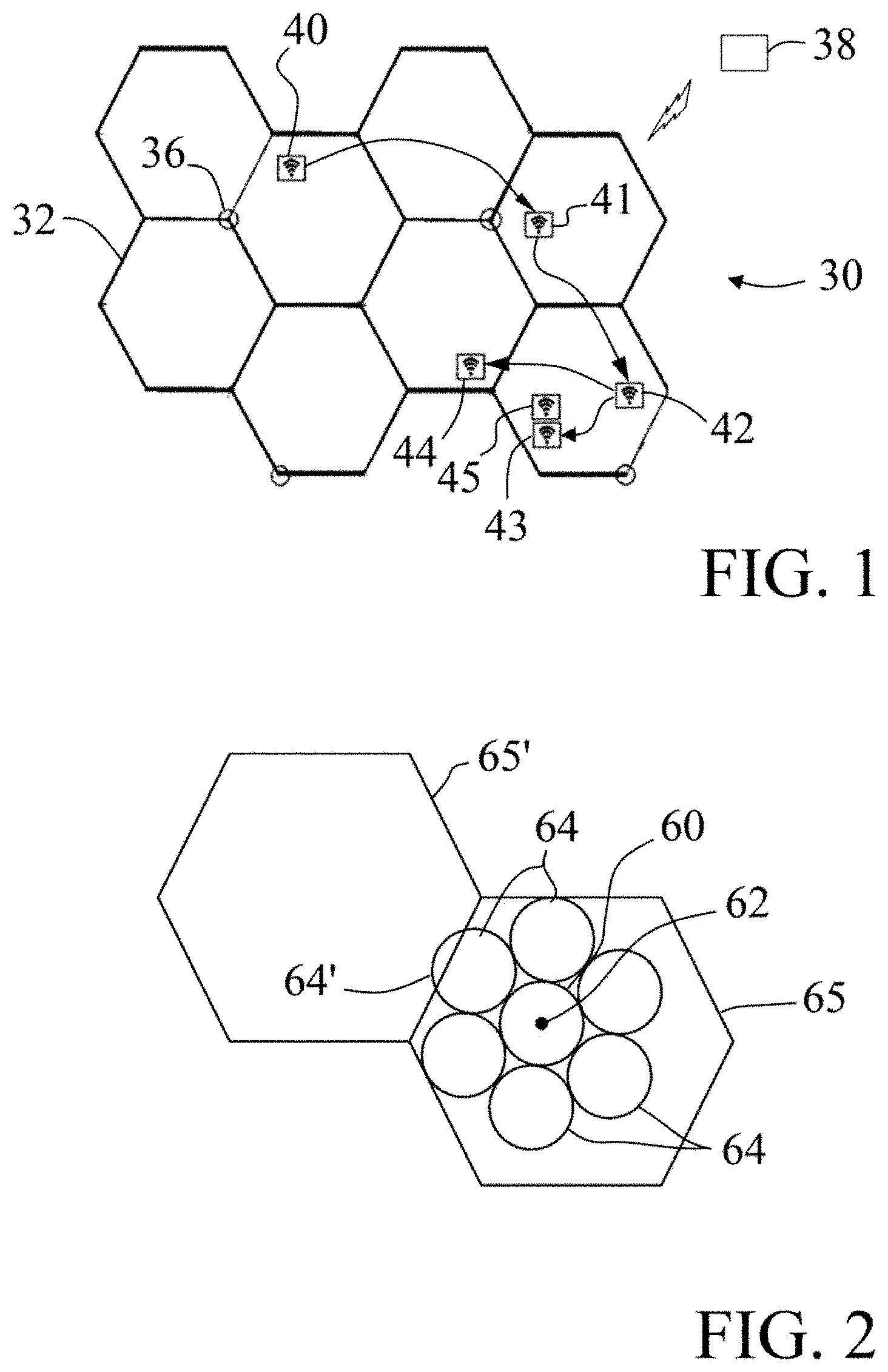
FIG. 1 illustrates a representative area 30 to demonstrate a method of and application for locations and/or activities of a user participating in a social networking service. The area 30 is shown as a cellular communication network including a plurality of cells 32 each disposed around a cellular communication antennae or base station 36. Within the area are a plurality of destinations each shown as including a WiFi Internet connection. The local user has one or more electronic devices, such as a mobile device that communicates with a remote server 38 via the cellular network and/or the WiFi connections. As will be appreciated the methods and applications of this invention can operate within any suitable size and configuration of the communication area, depending on what the user encounters.
Destination 40 is the home of the user. The user commutes to office 42 for work on most business days. On the way the user typically stops at the coffee shop 41. For lunch on most days, the user visits restaurant 43, but on Wednesdays the user typically meets a second user for lunch at restaurant 44.
At each destination 40-44, the user enters user information about the destination. The application and computer system that receives the user information automatically associates the user information with the destination, and stores the user information in a locations database, such as on the device and/or at server 38. The destination desirably is determined automatically and tagged with the user information, such as a location name of the destination and/or the user activity being performed at the destination. For example, destination 40 can be tagged as "home" and likely has numerous activities associated with it. The destination 41 can be tagged as its establishment name "Acme Coffee" or simply "coffee shop" and associated with the user activity of "buying coffee" or "latte time." The manually entered user information can then be automatically shared to the user's community in a social networking service. Similar user information is received for the other destinations 42-44. The user information desirably includes any other information about the location or activity, whether manually entered or automatically determined, such as the time of the visit or activity. Some destinations, such as home or work will likely have multiple user activities over a period of time, such as "coffee break," "meeting time," and/or "quitting time."
The computer system receives user information and associates the user information with the corresponding destination for multiple visits to each of the destinations 40-44. The computer system begins learning the locations and user activities. In embodiments of this invention, the user can be automatically prompted for confirmation of the user information upon arriving at a destination to confirm the location and/or user activity. For example, the user can be provided with an automatically generated list of previously entered user activities for the destination upon arrival, thereby promoting efficient collection of information. The items on the list can be listed in an order based upon a particular ranking, such as number of times entered previously or based upon a context, such as what activity is likely being performed at a particular time of a particular day.
Over time, the computer system learns the user information and begins automatically associating and identifying at least some user activities for corresponding locations. As will be appreciated, the automatic identifying of activities at locations will likely occur at different rates for different activities and locations, with some locations having fewer activities and/or more frequent visits than others. In preferred embodiments of this invention, the system automatically shares the user information in a social networking service upon automatically detecting further user arrivals at the destination. The automatic sharing of user locations and/or activities desirably occurs upon the user's arrival at the location, or at a particular time at the location. As such the invention includes an automatic detection of the user's arrival at a destination. The automatic sharing desirably operates without user action and prior to receiving any additional user information for the destination.
As an example, the user may typically purchase lunch at destination 43, but on Wednesdays typically goes to lunch with a friend or spouse at destination 44. The lunch routines of the user, and particularly the Wednesday lunch routine, can be learned by the system and automatically shared to the user's community upon the system automatically determining arrival, without manually input from the user. If the user is having lunch with a community member, then the system can automatically determine that both users are at the same location together to automatically recognize and confirm the lunch activity, and proceed to automatically share the information for both user's to their respective communities. If the user deviates from a routine, the system can know this, and refrain from sharing the typical destination, by the mobile device detecting a different location than the typical routine destination.
In embodiments of this invention, learning is accomplished by any known machine learning, data mining, and/or statistical techniques known in the art. Supervised, semi-supervised, and/or unsupervised approaches can be used, including, but not limited to Naive Bayes, Neural Networks, Support Vector Machine, and/or Associating Mining based techniques.
The invention desirably records all posted locations and activities. Throughout use, the disclosed invention learns the corresponding locations and the set of associated activities. More so, via comments made by the local user and by the local user's communities, the importance of the activities can be learned, such as for the prompting discussed above. Importance can be either local user or community biased. Additionally, importance can be biased by context. For example, community members as a whole might prefer "eating steak," "eating pizza," and "eating sushi," in that respective order. On the other hand, a local user might only eat sushi. Thus, local user bias will yield "eating sushi" only, while community bias will suggest "eating steak," "eating pizza," and "eating sushi," in that respective order.
In embodiments of this invention, locations are named according to a naming convention. Regardless of the naming convention used, a location is a physical geographical position. More so, physical geographic locations associate properties that can vary with or be dependent on context, namely time and date (hours, day of week, calendar date, etc.), users involved, and their relationships to each other, etc. This context can affect the associated location name or activity.
A common scheme that can be used to at least assist in identifying a physical geographical location is via the use of geocoding. Geocoding is the representation of a physical location via the pairing of latitudinal and longitudinal coordinates commonly referred to as a lat-long pair. Global Positioning Systems (GPS) can also determine a physical position coordinated via the triangulation of satellite transmissions. Typically GPS devices derive lat-long pairs which are made available to a variety of applications, often via map displays. GPS economics, accuracy, and simplicity of use resulted in their wide appeal and commercial success. Their continuous use in mobile devices is problematic, however, as they are energy intensive and rapidly drain the battery. Thus, alternative means or approaches to detect locations are desired.
Embodiments of this invention, as discussed above in FIG. 1, use or rely upon cell coordinates. When mobile devices communicate with a cell tower, they send their cell coordinates. These coordinates are recorded by the cell provider and are typically not publicly known. The cell phone or, in this case, the mobile device supporting the positional social media system, however, is aware of their coordinates. Thus, the device can store the cell coordinate position and automatically associate that cell coordinate with the location name provided by the local user. Over time, a location database of cell coordinate and named location pairs is created. The local portion of the database favors the local user. The union of all the local portions of the location database desirably constitutes the name space of the entire MPSM system of this invention. It is understood that any of the many database management systems or storage schemes known in the art can serve as the platform for this location database. Thus, location names can be provided without the need to rely on a global positioning system, reducing battery consumption. Location data can additionally or alternatively be purchased or otherwise provided by a third party.
An additional and/or alternative approach for automatic location determination relies on WiFi triangulations. Mobile devices can grow and maintain a database of known open WiFi networks, for clarity we call this database an Open-WiFi-Net database. Such mobile devices can use the information stored or derived from the information stored in the Open-WiFi-Net database to further refine the accuracy of a location without the use of GPS. Via point triangulation, when an Open-WiFi-Net database is available, the mobile operating system uses not only the cell tower but also WiFi triangulations to determine location. It is within the scope of this invention to use either or both cell-phone and WiFi triangulations to enhance location information in addition to any other disclosed approach. The mobile device can use the WiFi signal at a destination, such as destination 43, and additionally or alternatively any detectable open WiFi signal from a neighboring location, such as establishment 45 that is adjacent destination 43.
Having created the location database, searching, namely querying, the database uses the cell coordinate or the location name. That is, a location name query takes a location name as input and returns the corresponding cell coordinate. A cell coordinate query takes a location name as input and returns the corresponding location name. Note that, multiple names can be attributed to a given cell coordinate. That is, a local user might name a location using multiple different names; different users can name same locations using different names. Similarly, the same name can be used for different cell coordinate locations. All names corresponding to a given cell coordinate are returned. It is within the scope of this invention to selectively return names based on context, user, or community bias. Similarly, all cell coordinates corresponding to a given name are returned. Again, it is within the scope of this invention to selectively return coordinates based on context, user, or community bias. Ranking of the results returned can, when desired, be biased towards the local user.
A key concern for MPSM systems is collecting location information. Clearly any location information available within the mobile device should be harnessed. Thus, if GPS readings or any other location information is generated by other device resident applications, these readings are desirably recorded and utilized by the method and application of this invention. However, reliance on strictly other applications to obtain positional information is obviously not realistic or possible.
In embodiments of this invention, positional information is obtained via the use of geofences. A geofence is geographical boundary or "fence" surrounding a positional reading. As these boundaries are radius based, geofences are generally circular. Location transmission occurs whenever a handover of one cell tower to another occurs and is expected but not guaranteed to occur once a geofence boundary is crossed. To track location, periodic location transmissions are required. Since location transmissions must be minimized to conserve device energy, transmissions should only occur given geographical movement. Thus, crossing a geofence should generate such a transmission. Unfortunately, as crossing a geofence does not guarantee a location transmission, increasing the likelihood of a transmission is necessary.
In contrast to the known uses that surround a location with a single geofence, to increase the likelihood of a location transmission during movement, embodiments of this invention include surrounding a location geofence with a plurality of geofences. In one embodiment of this invention, a method of tracking a user includes determining a location of the mobile user, automatically establishing a first geofence around the location, and automatically establishing a plurality of additional geofences around the first geofence, with each geofence including a boundary. A location transmission is obtained by the mobile device upon crossing a boundary of the first geofence or any of the plurality of additional geofences. Multiple neighboring geofences are advantageous since they increase the likelihood of a location transmission as their boundaries are likewise likely to be crossed given movement.
FIG. 2 representatively illustrates a geofence 60 surrounding a current location 62. The geofence 60 is surrounded by additional geofences 64, all within a given cellular tower transmissions cell 65. Note that part of a neighboring geofence 64' is not fully within the cell 65, and hence, limits its benefits since a cell tower handoff by movement into cell 65' will generate a location transmission.
Geofences are implemented as software processes. Operating systems for mobile devices, such as but not limited to iOS and Android, limit the number of processes available to an application, and thus, the number of geofences is bounded. However, this limit typically exceeds the number of geofences generated using the approach described above. Therefore, additional processes are available, and hence, additional geofences are possible.
To increase the likelihood of a location transmission given movement, in embodiments of the invention, the remaining available processes implement static geofences. A static geofence is not dynamically generated given a new location as previously described. Rather, a static geofence is one that is fixed and represents those locations that are likely to be crossed by a given user. That is, users are habitual and frequent a limited set of locations often, for example but not limited to, their home, office, or favorite wine or sushi bar. By learning the frequent locations of users both individually and system wide and setting static geofences at these locations, biasing by the individual user, the probability of a location transmission is increased since additional geofences are likely crossed.
More so, these repeated locations vary by city, county, state, country, etc., as well as by other factors such as but not limited to day and time. Geographical and temporal presence can thus be used to vary the set of static geofences for a given user. For example, the set of static geofences for a given user will vary if the user is in Washington, D.C. rather than in San Francisco, Calif. Similarly, the set of static geofences for a given user will vary depending on the day and time. For example, a user frequents work on weekday mornings but frequents their favorite bagel shop on Sunday mornings and their favorite sushi bar on Thursday evenings.
Location transmissions suffer from a margin of error. Thus, it is difficult to precisely pinpoint and tag a location with a single transmission. Embodiments of this invention include automatic refining of a location of a user destination as a function of user routines, such as established by several user visits to the destination. As time progresses however, and a user frequents the same location multiple times, multiple location transmissions for the same location are recorded. In one embodiment of this invention, as representatively shown in FIG. 3, by overlapping the transmitted location along with its margin of error, a more accurate location can be derived. The overlapping of location transmissions for a given location 70 between streets 72 and within geofence 74, along with their margin of errors, represented as circles 76, yields an accurate location placement.
As shown in FIG. 3, location accuracy improves as related data are collected. Related data, however, can, at times, be somewhat erroneous (in terms of accuracy). A non-limiting example is an entrance to a shopping mall. Such an entrance is not necessarily at the center of the complex. Regardless of the entrance displacement from the center of the complex, the entrance location can still be used to increase location accuracy of the mall complex since the readings for the entrance are consistent. That is, for a given user, given mobile device, given carrier, etc., such location recordings remain consistent, all be it, slightly erroneous. Thus, even dirty, namely potentially inaccurate, data can result in correct location identification.
Additionally, having established a location, corresponding lat-long pair coordinates can be reversed engineered, namely mapped back onto, a place name. These derived lat-long pair coordinates become yet an additional information component that is used by a learning system to better refine a mapping to a named place. Machine learning, data mining, and statistical approaches that are supervised, semi-supervised, or unsupervised can be used, as known in the art, to cross-correlate all available location related data.
Once determined, the user information including the location and/or the user activities are automatically stored in a database. Embodiments of this invention include a computer server for providing and implementing the tracking and/or social networking service of this invention. The computer server includes a location module to determine the user location and/or a tagging module configured to correlate manually entered user information to a user destination and a database module configured to store user information including user locations and user activities at the user locations. For social media sharing, the server further desirably includes a communication module configured to automatically share a user activity in the social networking service upon further user arrivals at a corresponding one of the user or community locations. The server can also include an association module configured to associate the user activity with the corresponding user location.
Since location transmissions are needed during movement, the obvious question arises: when should the transmissions cease? That is, the system must determine when the user has arrived at a location to know when to perform the automatic steps discussed above. As discussed above, GPS systems are an energy drain on a mobile device, particularly as the GPS remains on and linked with the satellites to maintain location detection. Keeping a GPS application operating is a drain on both the processor and the battery of the mobile device. This invention provides a method and executable application that conserves energy by not continually running during use of the mobile device.
Embodiments of this invention provide an automated method of tracking a mobile user that includes providing a location module configured to receive location transmissions, placing the location module into a sleep mode, awakening the location module upon receipt of a location transmission, and determining a location with the location module. These placing, awakening, and determining steps are repeated, thereby placing the application into a sleep mode when not needed, thereby reducing the drain on the mobile device. The application goes into sleep mode when necessary or when desired, such as when the application is not needed, e.g., during extended movement or upon an arrival at a location. In embodiments of this invention, the application can go into sleep mode whenever a time since the device awakening exceeds a predetermined time allocation, or upon a determined rate of travel exceeding a predetermined threshold, thereby indicating extended travel.
FIG. 4 illustrates one exemplary, and non-limiting, method according to an embodiment of this invention to automatically detect arrival at a destination. The method is useful for tracking a user's location for any of various reasons, including, for example, monitoring community members, such as for triggering events, for safety, to provide automated reminders, and/or to provide automated suggestions to the user based upon the destination and/or surrounding area. The method of FIG. 4 is particularly useful for implementing the method and system discussed above, and can be used to implement other applications and method to provide energy savings compared to GPS location methods in mobile devices.
FIG. 4 includes a flow chart 100 that includes and/or represents three distinct situations, namely, an actual arrival, rapid movement, and sporadic movement without an actual arrival. Initially, the application is in sleep mode. Sleep mode is a state when no processing, and hence no energy consumption, takes place. Processing occurs once the application is awoken. A location transmission, such as a cell tower transmission or another application obtaining location information, awakens the application in step 102. Since the application awakening occurs due to a location transmission, the current location is known.
Once awakened, the application typically has a maximum amount of time to complete its processing. This limit, called time allotment, is set by the device operating system. All processing must complete prior to exceeding the time allotment. Ideally, the application should relinquish the processing flag back to the device operating system before the operating system forcefully removes the application from its active queue. Voluntarily terminating an application, namely returning it to the sleep mode, rather than having it forcefully terminated by the host operating system, is consider good citizenship. In step 104, the application initializes two timers, namely, a timer count representing the duration of time the process has executed since last awakening, and a stationary count representing the duration of time since the last detected device movement.
As time progresses and the process executes, the timer count is incremented in step 106. In one embodiment of this invention, whenever the application processing time exceeds the operating system time allocation (108--YES branch), the application is voluntarily placed in sleep mode 105. Note that the time allocation threshold is not necessary, but set to support good citizenship.
Assuming that the time limit has not been reached (108--NO branch), the application waits for t time units in step 110. After waiting t time units, new current location data are obtained is step 112 and stored locally on the device in step 114. In step 116, the current location is compared to the previously known location. If the two locations differ (116--NO branch), the rate of travel is computed in 118. If the rate of travel exceeds a threshold (120--YES branch), the process is desirably and voluntarily placed in sleep mode 122. Rapid travel is unlikely to result in an immediate or near term arrival; thus, checking locations while moving rapidly unnecessarily uses device energy. Eventually, the application process is awoken with the device moving at a slower rate. At that time, location checking is needed as an arrival might soon occur. If or when the rate of travel is slow (120--NO branch), movement is noted in step 124, and the loop is repeated commencing with the indication that additional processing time has elapsed in step 106.
Thus far, the arrival detection process has been voluntarily placed in sleep mode either due to having exceeded the self-imposed processing allotment quota which is desirably set just slightly below the operating system's time limit that leads to the removal of the application from the active queue (108--YES branch) or having travelled too rapidly (120--YES branch). Slow travel has resulted in simply recording the locations traveled, noting the movement exists in step 124, and awaiting either arrival or process termination.
Arrival is determined when the same location is detected for a sufficient duration of time. That is, an arrival is potentially determined when the location remains the same (116--YES branch). The stationary detection count is then incremented in step 126. If the stationary threshold is not yet exceeded (128--NO branch), the application waits fort time units in step 110, and the current location is obtained in step 112 and stored locally in step 114. A sufficient and predetermined duration at the same location eventually surpass the arrival detection threshold (128--YES Branch).
Once arrival is determined, arrival is declared in step 130, all data regarding the prior locations visited and stored locally are compressed and sent to the back end system supporting the application in step 132. A new location checkpoint is established in step 134, and the process is placed in sleep mode 136. From the sleep modes, the process of FIG. 4 repeats upon a known location.
Compression of location data is typically performed prior to local device to back-end system transmission as often the location data may not be needed at the back end. Location data may not be needed in cases, for example but not limited, during rapid travel. Although exemplified as having data compression occur prior to the sending of the data to the back-end, it is within the scope of this invention to compress location data prior to storing them locally.
All parameters described above for FIG. 4, for example t (for the time units), timer count, etc., are system and device dependent. Experimentation with and fine tuning of these and other parameters is within the scope of this invention. Also within the scope of this invention is the tuning of these and other parameters via the use of machine learning, data mining, and statistical approaches; supervised, semi-supervised, and unsupervised approaches can be used.
As discussed above, once the user has arrived at a destination, the location identification, user activities at the location, and/or any proximate third party members of the user's community are determined, if not already known. In this way, the devices automatically continually determine locations which can be used to identify any establishments and/or any community members at or within proximity to the location.
User activities are actions or events. Example user activities include but are not limited to "drinking wine," "flying," "reading," "attending conference," or "commuting." Users specify a particular user activity either by selecting from a provided list or by entering a different user activity. As discussed above, the provided list is generated by storing all previously entered user activities from all systems users but biasing the ranking of the provided activities based on context, the local user, their community, or a combination thereof.
All location and user activity pairs are stored in a database correlating the location with the activity. Any of the many database management systems or storage schemes known in the art can serve as the platform for this location-activity database. Furthermore, it is well understood in the art that the location-activity database can store many additional features. For example, the user identity and date and time of the pair are recorded.
Over time, the database grows and contains a sufficient number of pairs to support mining. The volume of data needed to mine correlations is dependent on the mining algorithm deployed and the level of accuracy needed. As known in the art, there are many machine learning, data mining, and statistical approaches to support mining. By using any of the many available such approaches, either individually or in combination, a local user activity preference per location is learned. Example learning approaches include supervised, semi-supervised, and unsupervised approaches including but not limited to Naive Bayes, Neural Networks, Support Vector Machine, and Associating Mining based techniques. The use of proprietary mining techniques is likewise within the scope of this invention. Once local user preference is learned, this preference is used to bias the aforementioned provided user activity list.
There are many approaches to identify locations. Automated location identification is accomplished by periodic checking of the current location. Periodicity of checking depends on, for example, the method used to determine the location, the desired frequency of reporting, recording, and notification, and the resources available to support the checking. Other periodicity determination approaches known in the art can likewise be used. One approach to automate location identification is the periodic determination of lat-long pairs via the use of a GPS device. An online service or a locally resident database can be used to correlate the GPS readings with locations. A preferred embodiment of this invention uses the aforementioned location database. Whenever a transmission to a connected cell tower is made, the cell coordinates of the transmitting device are used as a search query against the location database. If a match is detected, that location is identified. Another preferred embodiment detects locations upon the crossing of geofence boundaries as previously discussed. Note that both dynamically determined geofence boundaries and static geofence boundaries detect a location. Yet another preferred embodiment detects locations by capitalizing on location transmissions generated by any other application operating on the mobile device requesting location information.
In embodiments of this invention, local users, unless disabled by a local user, can be provided with automated notifications for themselves and for their community members. These notifications describe locations, activities, or correlated locations and activities for themselves and their community members. For example, unless disabled by the user, any time a user arrives at a new location, the local user and their communities can be notified of the user's new location. Automated location detection and notification, unless disabled, occurs without requiring a local user prompt.
Similarly, activity notification can be automated. Once a user arrives at a location, a set of activities previously occurring at that location is shared with the community or provided to the local user for information or sharing. If the user chooses to confirm at least one of these past activities, both the local user and their respective community members are notified of this at least one activity.
In another embodiment of this invention, automated notification involves shared experiences. A shared experience is one that associates multiple users. These associations can be passive or active. A passive association is strictly informative in nature while an active association requests an action. Non-limiting examples of passive shared experiences based on locations include: "User A is at User A's office, as is User B" and "User A is at home as is User C." Note that the first example involves multiple users at the same physical location, namely User A's office, while the second example involves multiple users at the same relative locations, namely their homes, but at different physical locations.
Similarly, passive shared experience notifications can be based on user activity. Non-limiting examples of passive shared experiences based on activity include: "User A is eating lunch as is User B" and "User A is participating in her favorite sport as is User B." Note that the first example involves multiple users participating in the same activity, namely eating lunch, while the second example involves multiple users involved in similar nature of activities, namely participating in their own favorite sport, which can be different actual activities, namely racquetball and swimming. In both passive shared experiences based on location and on activity, known in the art machine learning, data mining, and statistical approaches that are supervised, semi-supervised, or unsupervised approaches can be used to correlate relative locations and activities to physical locations and activities.
Other shared experiences can prompt for action, and are thus considered active. A non-limiting example of an active shared experience prompting for action includes: "User A posted a picture when at Penn Station; you are now at Penn Station; please post a better picture?" Thus, active shared experiences request the user to actively react. As above, active shared experiences can be location or activity based and can be absolute or relative. Note that it is likewise within the scope of this invention that individual user notifications be active and passive, in a similar manner as described above. However, the correlation of locations and activities both for passive and active are based strictly on the current, past, or projected expected activities of the individual user rather than those of multiple users.
Typically, only changed locations and activities are notified. That is, a location or activity is not typically repeatedly identified. However, a local user can request repetitive notifications based on any triggering condition known in the art.
Local users do not always remember to indicate a new location name or confirm which of the possible suggested name or names the system indicated for the given the location. As such, it is at times advantageous to prompt the local user for information. However, overly aggressive prompting might annoy the user. In embodiments of this invention, the application non-invasively prompts the user upon detecting an unknown location for the given local user. To avoid annoyance, prompting is repeated only rarely, say twice; the number of repeated prompts can be set as a parameter. Similarly, to provide a sense of comfort, if the back-end system recognizes the location based on the local user's community members' naming schemes, it prompts the local user with guiding messages, for example but not limited to "Many of your community members call this location The Tasting Room".
Identification of activities associated with a given location or a given community member can be additionally or alternatively automatically inferred in multiple ways. In embodiments of this invention, the computer system can automatically determine a positional destination of a user, such as by using a mobile device discussed herein, and automatically deduce as user information a location type and/or user activity of the positional destination. The user information can be deduced, at least in part, based upon the destination context. Exemplary context information includes, without limitation, time-dependent information (e.g., what time of day is it?), community information (e.g., who is also there?), and/or third-party information about the positional destination. This method, tied with automatic sharing of the user information in a social networking service, can provide a partially or fully automated process for determining user location and activity.
In one embodiment of this invention, the automatic deducing of the user information is based upon known or learned user routine. As discussed above, local users typically follow standard routines. Some routines are daily, weekly, monthly, etc. Other routines are context dependent. Regardless of the nature of the routine, learning via any of the many statistical, machine learning, data mining, or business analytical techniques known in the art, enables predictive behavior and automated activity and location suggestion. For example, but not limited to, if a local user always goes out to lunch at noon on every weekday, then if an unknown location is detected on a Tuesday at noon, then the application can suggest that this unknown location is likely a restaurant and the activity is likely eating lunch. Similarly, routine identification enables the prevention of transmissions both positional and informational. For example, but not limited to, if a local user always goes to sleep at midnight on Sunday through Thursday and awakens at 7:00 am the following day, then energy can be saved if the application voluntarily places itself in sleep mode during the hours that the local user is known to be sleeping. Additionally, routines can involve a sequence of activities and locations. A non-limiting example of a sequence of activities includes: On weekdays, Eric arrives at his office at 8:00 am, drinks coffee at 10:00, develops software from 11:00 am until 5:00 pm, commutes home at 5:30, and finally, arrives at home at 6:00 pm.
Another location and/or activity deduction approach is by association. The automated deducing can include automatically associating a user with a second user at a positional destination. If the second user's location and/or second user's activity is known, then the system can automatically infer the location type and/or user activity of the first user from the second user location and/or activity. Consider a previous known event such as: "Community member Sally swimming at the Somerset pool", assuming that the Somerset pool location was previously identified. As an example of automatically, determining a current activity of community user Sam, the system identifies through location determination that Sam is currently at the same location as Sally, and also that Sally is currently at the Somerset pool. From this information, possible automatically postulated associations and activities are: "Sam is at the Somerset pool", "Sally is swimming", and "Sam is swimming". Thus, it is possible to infer an activity for a community member from association with another community member. It is within the scope of this invention to use any logical inference methods known in the art to generate plausible associations. It is also within the scope of this invention to obtain confirmation of the plausible postulated activity by the community member, in this case Sam, by asking either Sam or Sally or by any other means known in the art.
Desirably the computer system operating the MPSM automatically stores past user information, including past location type and/or user activity of the positional destinations of all users. User information for future visits to repeat positional destinations can be automatically deduced as a function of the stored past location type and/or user activity of the positional destination. In embodiments of this invention, the system can rely on recorded previous activities of a user, a community member, or any system user at a given location to postulate on a user's activity at a given location. Past context information for past visits to the positional destination by the user and/or community members of the user can be compared to a current context of the user's visit to the positional destination to deduce the user information. In one embodiment, the system can reduce possible location types and/or user activities as a function of the past location type and/or user activity of the positional destination.
As an example, at a given Location A, users previously studied, talked, ate, and drank. Thus, if a user's positional destination is detected as at Location A, then plausible activities postulated can be studying, talking, eating, and drinking. More so, if the given user's community members only previously talked, ate, and drank, it is with a higher probability to postulate that the given user is talking, eating, and drinking rather than studying. Furthermore, if the given user visited Location A previously, but only talked and drank, then an even higher probability is that the user is currently talking and drinking rather than eating and studying. It is within the scope of this invention to postulate some or all of the previously detected activities of a given location. More so, it is within the scope of this invention to rank order the activity suggestions according to the relevance of the previously visiting users to the given current user. As previously described, the system can request confirmation of suggested activities through the user's mobile device.
The system can additionally or alternatively reduce possible location types and/or user activities as a function of the past location type and/or user activity of the positional destination as a function of the time of day. The system can rank possible location types and/or user activities of the positional destination based upon known past time periods corresponding to the time of day of the current user visit. For example, again given Location A, if previous visiting users were recorded to study one or more times during the intervals: 3:00-4:30 PM and 7:30-9:00 PM, and to think one or more times during the intervals: 4:00-7:00 PM and 8:30 PM-2:00 AM, then a current visiting user at Location A at 3:15 PM is likely studying, at 4:15 PM is likely to be either studying or drinking, and at 1:00 AM is likely to be drinking. More so, if the given user's community members only studied between 3:15-4:30 PM then it is with a higher probability to postulate that the given user is studying rather than drinking at 4:15 PM. Furthermore, if the given user visited Location A previously but only studied, then an even higher probability is that the user when at Location A is studying. It is within the scope of this invention to postulate some or all of the previously detected activities of a given location. More so, it is within the scope of this invention to rank order the activity suggestions according to the relevance of the previously visiting users to the given current user. As previously described, the system can request confirmation of suggested activities through the user's mobile device.
In embodiments of this invention, time context alone can be used to postulate activities. For example, if most days, a user is recorded to be drinking coffee between 9:00-10:00 AM, then, without contradictory information, a plausible activity postulate is that at 9:35, the user's activity is drinking coffee. Again, as previously disclosed, it is within the scope of this invention to rank order the postulated activity suggestions according to the relevance of the previous users to the given current user and/or to obtain confirmation of suggested activities.
Additionally, it is also within the scope of this invention to rank order the time postulates based on frequency of occurrence within the time interval. This rank ordering applies to both location based and location independent time based postulates. For example, if in the interval 4:00-4:30 PM, community members studied 25 times but drank 5 times then, at 4:15, it is with a higher probability to postulate that the given user is studying rather than drinking.
In embodiments of this invention, the system can search and/or use, if available, external, third party information about the positional destination for postulating activities for a given location. For example, third party vendors might provide, either free of charge or for a fee, activity information for a given site. Consider a marketing website of a centralized homepage for a grocery store chain. Such websites are likely to contain addresses of many or all of the associated stores. Since these stores all support shopping, an activity associated with these locations is shopping. Similar information can be derived or purchased from other sources such as but not limited to commercial information repositories. Additionally, maps can be parsed. Given a location of a road, an activity of that location is likely to be driving. Various and alternative third party information gathering approaches and their incorporation into activity classification and postulation can be incorporated into the method and system of this invention.
Suggested activity information, particularly but not limited to information obtained or derived from third party vendors, might be additive or might be contradictory, Thus, combining or reconciling potential activities is needed. The use of voting schemes, biased based on credibility of the source or on frequency, such as majority, or other known techniques, can be incorporated in the method and system of this invention. Note that differing suggested plausible activities may additive or may be contradictory. The use of techniques such as, but not limited to, conflict resolution methods, ontology determination, and clustering, etc., can be incorporated to recognize potential conflicts and to expand classification is within the scope of this invention.
Additionally, the classification of plausible activities based on activities occurring in the surrounding vicinity is likewise within the scope of this invention. For example, consider an unknown location adjacent to two known locations, such as, but not limited to, two neighboring stores or two neighboring beaches. For the neighboring stores, known activities might include shopping and strolling, while for the neighboring beaches, known activities might include sunbathing and swimming. Given location proximity, it is within the scope of this invention to suggest a user's activity at the unknown location to be either shopping and strolling or sunbathing and swimming, respectively. Confirmation can always be obtained for suggested activities and to bias suggested activities based on user familiarity and frequency of occurrence.
In embodiments of this invention, local users can opt to delay their notifications. That is, once a location is visited or an activity occurs, a local user can opt to have the notification of the location or activity be delayed by some period of time. Delaying a notification provides the local user with the ability to notify their community of the location visit or activity occurrence, but still provides the local user time to progress to the next location or activity.
Notifications can be complemented with correlations with other community members. That is, both the local user and their respective community can be automatically notified with a comparison. A comparison, for example but not limited to, can identify other community members having previously conducted a specific activity or having visited a given location previously. Comparisons are made by checking other community member locations and activities against those of the local user. Checking is performed via a search of the location-activity database. If a match exists within a specified or predetermined period of time, a comparison notification is made automatically. The period of time can be arbitrarily set or can follow some logical time quantum such as hour, day, week, etc.
Locations and activities are known by name. However, in addition to a name, locations and activities can have associated personal labels. Labeling locations and activities can detail familiarity to the location and activity. User labels for locations can be surrogate names, for example, "favorite city" for Chicago, can be songs or sound waves, for example song words "my kind of town, Chicago is" for Chicago, can be a picture, for example "the Water Tower" for Chicago, can be a video, for example "a panoramic view of the Chicago skyline" for Chicago, or any combination of these and other multimedia tags supported by the local device. Similarly, user labels can exist for activities. For example, "favorite vice" for drinking wine, or it can be a song or sound wave, for example the song words "a bottle of red" for drinking wine, or it can be a picture, for example, a wine bottle picture for drinking wine, or it can be a video, for example "a panoramic view of a vineyard" for drinking wine, or any combination of these and other multimedia tagging labels supported by the local device.
In embodiments of this invention, local users and community members can comment on their own and each other's locations and activities. Comments can take any of the many multimedia forms provided by the local device. These include, but are not limited to, text, sound, pictures, videos, or any combination thereof. Multiple comments can be made by the local user, their community, or combination thereof. In addition to stating their opinions (commenting), community members can prompt for clarification. That is, by issuing "what" comments, community members request additional information on the posted locations and activities. Additionally, user can "like" their own and each other's locations and activities. By "liking" a location or activity, community members express their satisfaction of their respective community members' presence in terms of location and activity. Multiple community members as well as the local user can "like" a location and activity.
The method and systems of this invention can track vast data on both the local user and their respective community members. These data cover, including but not limited to, locations, activities, and also individuals both who are system users and those who are not. These data can be stored and summarized. A summary of the local user and community member locations, activities, time durations involved in each of these locations and activities, individuals who they encountered, etc., can be computed and presented to the user. This summarization can range from simple statistical aggregation to advanced correlations as derived by any of the many, both individually and combined, machine learning, data mining, business analytics, and statistical techniques known in the art.
Information that can be aggregated or derived can answer, exemplary but not limiting, questions such as: how much time a local user spent doing things, such as, working at home, working out, walking the dog, commuting to work; how much time a particular community member spent doing things, such as, working at home, working out, walking the dog, commuting to work? (Note that the information derived for the community member is based strictly on the information that that particular community member chose to share.); who are the five most common individuals that a particular user interacts with?; what is the likelihood that after seeing a particular user, the given local user would see a particular different individual?; which activities and locations are most closely associated with each other and when are they most likely to occur?; which three users among a given community are most likely to visit a particular location together?
Local users can be provided with summaries of their locations, durations at these locations, and activities at these locations. Furthermore, at the discretion of the local user, these summaries are made available to their community members.
The system can also generate and maintain both aggregation and derived information. This information can be used to optimize suggestions to avoid obstacles, for example, but not limited to preferred routing of commuting path, promoted target advertising, for example but not limited to location of nearby ice cream store for those users who frequently record "eating ice cream" as an activity, and a host of other informational services known in the art.
The invention includes a method of determining infection risks and/or medical conditions of users participating in a social networking service using the above described monitoring and learning method and system. From the automated monitoring of destinations and user activities described above, the computer system learns activity patterns for users. In embodiments of this invention, risk metric values assigned to locations and activities of the user can be determined and analyzed for possible indicators of health concerns.
Statistical techniques, machine learning, data mining, pattern detection and/or any other analytical techniques known in the art can be incorporated as needed to learn users' behavioral patterns. This enables the system to improve performance by fine-tuning the alert recommendation criteria.
Embodiments of this invention further include a consideration or time at, or other persons involved at, the location and/or activity of the user. For example, the method can include a determination of a corresponding user participation time for the each of the locations and/or activities, and scaling the risk metric for the each of the locations and/or activities according to the corresponding user participation time. If the user is in a high-risk area for 2 days, then the risk assessment is higher than for someone who simply drove through the area without stopping. Likewise, going to a restaurant for one hour of dining is riskier than for 5 minutes for take-out.
The risk metric for each of the locations and/or activities can be assigned by any suitable scaling. For example, FIG. 5 shows an exemplary table of infection rates for various areas in Maryland, which can be used to provide a location risk factor. For example, for each of the locations, the assessment score can be normalized by the number of infected people in an area around the location. FIG. 6 shows a representative activity scale, such as are currently provided by government and/or healthcare agencies for mitigating Covid-19. The scales can be fixed or fluid, as needed, and can vary depending on the pathogen. The risk metrics of the user risk assessment can be adjusted (e.g., increased) upon an in-person contact at the locations and/or activities, particularly if the contact person is known to have a negative risk assessment based upon, for example, the factors and methods described herein. Other known information, such as a person's employment situation or general health condition, can be taken into consideration as well. For example, is a user or a contact person an `essential worker` who is on the job, or working from home?
Using the aforementioned measures, for example, embodiments of this invention determine a categorical degree of risk of infection, for example, low, medium and high, that visiting locations, performing activities, and/or physically interacting with a particular community member poses based on that member's prior geographical presence and behavioral patterns. By identifying the degree of disease prevalence at the geographical location resided or visited by a community member and the risks associated with that community member's activities, a scoring of infection likelihood can be computed. That score can be computed using any metric known in the art that incorporates the aforementioned measures. An exemplary computation, without limitation, is as follows: User Risk Assessment--Warning Factor (W) 1. Location metric Normalize the number of infected people for 100,000 (L)=Rate-per-100K/Scale-Rate 2. Activity metric Normalize accepted activity "risk factors" (R)=Risk-Factors/Scale-Risk 3. Duration metric Normalize the duration per time unit (D)=Duration-in-Minutes/Scale-Time-Unit
.times..times..function..times..times..times..times..times..times..times.- .times..times..times..times..times..times..times..times..times..times..tim- es..times..times..times..times..times..times..times..times. ##EQU00001##
By categorization of the computed score, each member can be assigned a risk category indicating the likelihood that the member might be infected. As an example, a possible hypothetical categorization is that scores below 10, between and including 10 and 100, and above 100 are labeled low, medium, and high, respectively. Other categorization schemes with greater or lesser granularity and differing threshold boundaries are likewise within the scope of this invention. Prior to meeting any community member, the risk category of the member to be met is provided to the scheduler of the meeting to determine the risks associated with the potential meeting.
Consider the following non-limiting example used strictly without limitation to illustrate an embodiment of the invention. It is also within the scope of this invention to incorporate other known in the art evaluation metrics and/or database recording organizations that account for community interaction, location presence, and date, time, duration and types of activities associated with a given location and community member.
Assume Sally (ID #11) is considering meeting outside at a social distance with one of three friends: Bob (ID #33), Jim (ID #88) or Mary (ID #99). Of concern to Sally is staying safe, and thus, she considers the warning factor (W) associated with Bob, Jim, and Mary. All locations, durations, and types of activity for every friend under consideration is obtained from the database records shown in FIG. 7. The Covid-19 risk assessment scores for activity types are taken from the guidelines shown in FIG. 6. The cumulative Covid-19 cases for all 23 Maryland counties and the City of Baltimore are obtained from FIG. 5. Thus, for this hypothetical example: Bob (ID #33): Prince George County; working out at a gym; for 60 minutes Montgomery County; eating at an inside restaurant; for 90 minutes Allegany County; went to a bar; for 150 minutes Jim (ID #88): Calvert County; eating at an outside restaurant; for 120 minutes Mary (ID #99): No recorded activities
Using the above exemplary, the scoring function with an exemplary scale-rate of 1000, scale-risk of 2, and scale-time-unit of 30, the warning factors of each friend is as follows.
.times..times..times..times..times..times..times..times..times..times..ti- mes..times..times..times..times..times..times..times..times..times..times.- .times..times..times..times..times..times..apprxeq..times..times..times..t- imes..times..times..times..times..times..times..times..times..times..times- ..times..apprxeq. ##EQU00002## ##EQU00002.2## Thus, using the above categorization, meeting with Bob, Jim, and Mary has a high, medium, and low risk, respectively.
Although in the example, only activities for Dec. 10, 2020 are included in the warning factor computations, it is within the scope of this invention to include a smaller or larger than a single day window observation of activities. That is, any time duration can be used as an activity window. It is likewise within the scope of the invention to rely on infection guidelines to determine the duration length of the activities observation window, such as a one- to two-week period before the meeting, representing any recognized incubation period for a pathogen.
It is likewise within the scope of this invention to also account for interactions with community members. That is, the weighting function can be expanded to account for interaction with community members. For example, the warning factor W can be modified to include a meeting factor M.sub.i,j that indicates the effects of the warning factors W.sub.i and W.sub.j from the previous activities observation duration for every pairing involving a person being scored.
It is also within the scope of this invention for the automated decision to issue an alarm, to the user or another person, to be based, at least in part, on the severity of the infection risk, in going to a location, performing an activity, or having an in-contact meeting. In embodiments of this invention, when an alarm is triggered, the condition or conditions triggering the alarm are desirably identified. It is also within the scope of this invention to have different sets of conditions to trigger an alarm rather than a single triggering condition. Additionally, it is also within the scope of this invention to have differing triggering conditions depending on the differing risk metric sets.
It is also within the scope of this invention to weigh the risk metrics that are monitored and trigger the alarm differently. Risk weighting can be based on frequency of occurrence within a given time period, severity of the indication that the risk represents, with weighting schemes known in the art.
In embodiments of the invention, the MPSM methods and systems can be combined in automated communication with, medical devices (e.g., IR thermometers) electronic biosensors, and/or other smartphone apps. Exemplary biosensors include without limitation wearable monitors, such as, pulse, body temperature, fitness, or other electronic body monitors, or non-wearable electronic devices such as scales or fitness machines. FIG. 8 illustrates a smartphone 170 that is a user electronic device executing the MPSM method according to embodiments of this invention. The smartphone is in wireless communication, such as using Bluetooth.RTM. or any of other similar communication protocols, with a wrist-wearable device 172, such as a fitness monitor or a smartwatch. An inference engine can consider the information about the user gathered by the device 172 in detecting, analyzing, or correlating any possible infection according to methods of this invention. For example, there are instances of Covid-19 causing pulse irregularities, and/or high blood pressure, in addition to fever.
The invention further includes a method of determining locations and/or activities of users participating in a social networking service. The method can be used to track members and provide warnings to the tracked user, or to provide a notification or alert/alarm to the user doing the tracking. The tracking and notification are particularly useful in monitoring health conditions and/or risks to other users. In embodiments of this invention, locations and/or activities of members of a social media community are automatically and continually tracked, such as using the methods described above. The tracked location/activity information is automatically displayed for each of the plurality of members on one or more of electronic devices of the other members, depending on the particular user settings.
In embodiments of this invention, a member has the opportunity to establish a triggering condition for an other one or more of the plurality of members via her or his electronic device. The tracking system automatically monitors the one or more members for the triggering condition via the corresponding electronic device(s) of the other user. Upon automatically determining an occurrence of the triggering condition, an automated communication of the occurrence of the triggering condition is sent to the user setting the triggering condition, and any other user also added as a notification recipient. This can be used to track children or other family members, and preempt a risky activity.
A primary motivator for the use of MPSM systems is maintaining awareness of the current status of user's community members. Often, maintaining awareness is tantamount to knowing when a community member has met a triggering condition. Examples of a triggering condition include, but are not limited to: proximity to, arrival at, or departure from, a specified location; and/or an activity or condition of at least one of the community members automatically determined using that member's electronic device of the members, such as having a certain medical condition or engaging in a particular user activity or function. The triggering condition can be selected from automatically generated predetermined condition selections displayed in a user interface on the user electronic device, or created from predetermined templates provided to and/or created by the user.
Specified locations for the triggering conditions can be absolute or relative and/or specific or global. As used herein, absolute locations refer to specific geographic locations independent of the user, for example, an address such as 111 Chestnut Street, Chicago, Ill., while relative locations specify user related locations such as the user's "home," "work," or "favorite coffee shop." Specific locations can be absolute or relative and specify an exact location, while global locations indicate neighborhoods such as Chevy Chase, Md. Thus, triggering conditions based on locations, either absolute or relative, and/or specific or global can be set.
Some medical conditions can be determined by applications available on the mobile device. For example, applications running on mobile devices and known in the art include but are not limited to, heart rate monitoring and temperature sensing. Additionally some medical devices incorporate state of being applications. Regardless of the means by which the medically related condition is determined or tracked, triggering conditions can be specified and another user notified automatically upon the determination of the condition, or a possibility thereof.
In embodiments of this invention, the MPSM learns and derives user activities and/or locations, such as by the methods disclosed herein. Triggering conditions related to activities and/or location proximity can be set by the user or other users. For example, triggering conditions can be set by a user for the purpose of being automatically informed when a community member is automatically determined to be eating, shopping, or walking. Similarly, triggering conditions can be set for the purpose of being automatically informed when any one or more community member is automatically determined to be near the user, a location (e.g., restaurant, airport, or mall), or near another community member.
Regardless of the triggering condition set, when the community member meets the condition, the user is notified. In one embodiment of this invention, the triggering condition can be set to send the alert notification to one or more community members in addition to, or as an alternative to, the user that sets the triggering condition. Notification can be accomplished by any of the multiple known in the art notification schemes including but not limited to SMS messages, phone calls, e-mail messages, and/or application pop-ups or push notifications.
Thus, the invention provides a method and system for actively monitoring for potential medical concerns based upon location and activity detection, and any other health related data from an electronic device or a related sensing device. The invention is based upon the methods of this invention for tracking and learning user locations and activities, and can share concerns with community members and/or health professionals. The method is executed by a computer system, preferably through a mobile device, and includes automatically monitoring learned user activity patterns.
The invention illustratively disclosed herein suitably may be practiced in the absence of any element, part, step, component, or ingredient that is not specifically disclosed herein.
While in the foregoing detailed description this invention has been described in relation to certain preferred embodiments thereof, and many details have been set forth for purposes of illustration, it will be apparent to those skilled in the art that the invention is susceptible to additional embodiments and that certain of the details described herein can be varied considerably without departing from the basic principles of the invention.
* * * * *
D00000
D00001
D00002
D00003
D00004
D00005
M00001
M00002
XML
uspto.report is an independent third-party trademark research tool that is not affiliated, endorsed, or sponsored by the United States Patent and Trademark Office (USPTO) or any other governmental organization. The information provided by uspto.report is based on publicly available data at the time of writing and is intended for informational purposes only.
While we strive to provide accurate and up-to-date information, we do not guarantee the accuracy, completeness, reliability, or suitability of the information displayed on this site. The use of this site is at your own risk. Any reliance you place on such information is therefore strictly at your own risk.
All official trademark data, including owner information, should be verified by visiting the official USPTO website at www.uspto.gov. This site is not intended to replace professional legal advice and should not be used as a substitute for consulting with a legal professional who is knowledgeable about trademark law.