Registration mapping toolkit for geofences
Jones
U.S. patent number 10,674,309 [Application Number 15/903,940] was granted by the patent office on 2020-06-02 for registration mapping toolkit for geofences. This patent grant is currently assigned to GEOFRENZY, INC.. The grantee listed for this patent is GeoFrenzy, Inc.. Invention is credited to Benjamin T. Jones.


View All Diagrams
| United States Patent | 10,674,309 |
| Jones | June 2, 2020 |
Registration mapping toolkit for geofences
Abstract
Systems and methods for creating a database of geofences and registering geofences, with each geofence in the database being associated with an IP address, preferably an IPV6 address. Each geofence is defined using at least one geographic designator, preferably real property boundaries. Entitlements can be associated with geofences relating to permissive and prohibitive activities within the geofences.
| Inventors: | Jones; Benjamin T. (Henderson, NV) | ||||||||||
|---|---|---|---|---|---|---|---|---|---|---|---|
| Applicant: |
|
||||||||||
| Assignee: | GEOFRENZY, INC. (Tiburon,
CA) |
||||||||||
| Family ID: | 55410445 | ||||||||||
| Appl. No.: | 15/903,940 | ||||||||||
| Filed: | February 23, 2018 |
Prior Publication Data
| Document Identifier | Publication Date | |
|---|---|---|
| US 20180184243 A1 | Jun 28, 2018 | |
Related U.S. Patent Documents
| Application Number | Filing Date | Patent Number | Issue Date | ||
|---|---|---|---|---|---|
| 15204413 | Jul 7, 2016 | 9906905 | |||
| 15007661 | Jul 19, 2016 | 9396344 | |||
| 14740557 | Mar 8, 2016 | 9280559 | |||
| 14728259 | Jun 7, 2016 | 9363638 | |||
| Current U.S. Class: | 1/1 |
| Current CPC Class: | H04L 61/1511 (20130101); G06F 16/951 (20190101); H04W 4/021 (20130101); G06F 16/29 (20190101); H04L 61/1582 (20130101); H04L 67/18 (20130101); H04L 67/141 (20130101); H04L 61/6059 (20130101); B64C 39/024 (20130101); G06F 21/604 (20130101); H04L 12/2816 (20130101); H04L 61/2007 (20130101); H04W 12/0804 (20190101); H04L 67/2814 (20130101); H04W 68/00 (20130101); G08G 5/006 (20130101); G08G 5/0069 (20130101); H04L 67/02 (20130101); H04L 61/609 (20130101); H04W 80/04 (20130101) |
| Current International Class: | G06F 16/29 (20190101); G06F 16/951 (20190101); G06F 21/60 (20130101); H04L 12/28 (20060101); H04L 29/08 (20060101); H04W 12/08 (20090101); H04L 29/12 (20060101); G08G 5/00 (20060101); H04W 68/00 (20090101); B64C 39/02 (20060101); H04W 4/021 (20180101); H04W 80/04 (20090101) |
References Cited [Referenced By]
U.S. Patent Documents
| 6844990 | January 2005 | Artonne et al. |
| 6865028 | March 2005 | Moustier et al. |
| 6885817 | April 2005 | Artonne et al. |
| 6895180 | May 2005 | Artonne et al. |
| 6920129 | July 2005 | Preston et al. |
| 7498985 | March 2009 | Woo et al. |
| 7525933 | April 2009 | Hall |
| 7613467 | November 2009 | Fleischman |
| 7865416 | January 2011 | Graff et al. |
| 8016426 | September 2011 | Artonne et al. |
| 8052081 | November 2011 | Olm et al. |
| 8103567 | January 2012 | Graff et al. |
| 8149801 | April 2012 | Hall |
| 8285628 | October 2012 | Graff et al. |
| 8292215 | October 2012 | Olm et al. |
| 8346578 | January 2013 | Hopkins et al. |
| 8483652 | July 2013 | Hall |
| 8493207 | July 2013 | Diem |
| 8510190 | August 2013 | Graff et al. |
| 8582724 | November 2013 | Olshansky et al. |
| 8588818 | November 2013 | Huang et al. |
| 8634804 | January 2014 | McNamara et al. |
| 8717166 | May 2014 | Diem |
| 8718598 | May 2014 | Johnson |
| 8753155 | June 2014 | Olm et al. |
| 8812027 | August 2014 | Obermeyer et al. |
| 8832293 | September 2014 | Wang |
| 8837363 | September 2014 | Jones et al. |
| 8880101 | November 2014 | Fraccaroli |
| 8897741 | November 2014 | Johnson |
| 8918075 | December 2014 | Maier et al. |
| 8938201 | January 2015 | Boulton |
| 8971930 | March 2015 | Li et al. |
| 8990356 | March 2015 | Mcpherson et al. |
| 8991740 | March 2015 | Olm et al. |
| 9071931 | June 2015 | Diem |
| 9280559 | March 2016 | Jones |
| 9363638 | June 2016 | Jones |
| 9491577 | November 2016 | Jones |
| 2001/0015965 | August 2001 | Preston |
| 2002/0035432 | March 2002 | Kubica et al. |
| 2003/0036949 | February 2003 | Kaddeche et al. |
| 2004/0148294 | July 2004 | Wilkie et al. |
| 2005/0203768 | September 2005 | Florance et al. |
| 2007/0220038 | September 2007 | Crago |
| 2008/0291318 | November 2008 | Artonne et al. |
| 2010/0044499 | February 2010 | Dragan et al. |
| 2010/0198714 | August 2010 | Orfano |
| 2011/0105151 | May 2011 | Hall |
| 2011/0136468 | June 2011 | McNamara et al. |
| 2011/0208797 | August 2011 | Kim |
| 2012/0102489 | April 2012 | Staiman et al. |
| 2012/0172027 | July 2012 | Partheesh |
| 2012/0265685 | October 2012 | Brudnicki |
| 2013/0091016 | April 2013 | Shutter |
| 2013/0097046 | April 2013 | Krishnamurthy et al. |
| 2013/0225196 | August 2013 | James et al. |
| 2013/0267196 | October 2013 | Leemet et al. |
| 2013/0314398 | November 2013 | Coates et al. |
| 2014/0006951 | January 2014 | Hunter |
| 2014/0057648 | February 2014 | Lyman et al. |
| 2014/0100900 | April 2014 | Abhyanker |
| 2014/0171013 | June 2014 | Varoglu et al. |
| 2014/0208397 | July 2014 | Peterson |
| 2014/0248887 | September 2014 | Alkabra et al. |
| 2014/0282829 | September 2014 | Dabbiere et al. |
| 2014/0295944 | October 2014 | Faircloth |
| 2014/0335823 | November 2014 | Heredia et al. |
| 2014/0339355 | November 2014 | Olm et al. |
| 2014/0340473 | November 2014 | Artonne |
| 2015/0031398 | January 2015 | Rahnama |
| 2015/0087263 | March 2015 | Branscomb |
| 2015/0099461 | April 2015 | Holden et al. |
| 2015/0134143 | May 2015 | Willenborg |
| 2015/0172862 | June 2015 | Kau et al. |
| 2015/0281507 | October 2015 | Konen et al. |
| 2016/0007156 | January 2016 | Chiou et al. |
| 2016/0035054 | February 2016 | Branscomb et al. |
| 2016/0073225 | March 2016 | Ganesalingam et al. |
| 2016/0169696 | June 2016 | Butts et al. |
| 2016/0203522 | July 2016 | Shiffert et al. |
| 2016/0323241 | November 2016 | Jones et al. |
| 2016/0357782 | December 2016 | Jones |
| 2016/0358432 | December 2016 | Branscomb et al. |
| 2016/0359986 | December 2016 | Jones |
| 2016/0360360 | December 2016 | Jones |
| 2017/0150308 | May 2017 | Jones |
| 2017/0230791 | August 2017 | Jones |
| 2017/0238129 | August 2017 | Maier et al. |
| 2017/0249712 | August 2017 | Branscomb et al. |
Other References
|
Christian Maihofer, "A Survey of Geocast Routing Protocols," IEEE Communications Surveys Second Quarter 2004, vol. 6, No. 2, pp. 32-42 (2004). cited by applicant . Robert Barr, What 3 Words, Mar. 2015, v1.1, Lymm, Cheshire, UK. cited by applicant. |
Primary Examiner: Patel; Hitesh
Attorney, Agent or Firm: NEO IP
Parent Case Text
CROSS-REFERENCE TO RELATED APPLICATION
This application is a continuation of and claims priority to U.S. patent application Ser. No. 15/204,413, filed Jul. 7, 2016, which is a continuation of U.S. patent application Ser. No. 15/007,661, filed Jan. 27, 2016, now U.S. Pat. No. 9,396,344, which is a continuation of U.S. patent application Ser. No. 14/740,557, filed Jun. 16, 2015, now U.S. Pat. No. 9,280,559, which is a continuation of U.S. patent application Ser. No. 14/728,259, filed Jun. 2, 2015, now U.S. Pat. No. 9,363,638, each of which is incorporated herein by reference in its entirety.
Claims
What is claimed is:
1. A method for looking up at least one geofence, comprising: a mobile device determining a first location of the mobile device, wherein the first location of the mobile device is within a predetermined proximity of at least one geographic location; identifying at least one geofence in a database associated with the at least one geographic location; upon the mobile device relocating from the first location of the mobile device to a second location within the at least one geofence associated with the at least one geographic location, restricting or allowing usage of applications on the mobile device based on at least one class or at least one entitlement; wherein the at least one geofence is defined by an anchor Internet Protocol version 6 (IPv6) address, wherein the anchor IPv6 address includes metadata, and wherein the metadata includes at least one class; and redefining the metadata via lookup table identifiers, wherein the lookup table identifiers are included in the metadata.
2. The method of claim 1, further comprising the mobile device automatically requesting access to an Internet connection associated with the at least one geofence.
3. A system for looking up at least one geofence comprising: a server including at least one processor and a geofence database; the geofence database including at least one geofence defined by a plurality of Internet Protocol version 6 (IPv6) addresses; and at least one mobile device operable to determine a geographic location and communicate the geographic location over at least one network to the server; wherein the at least one mobile device is operable to determine an anchor IPv6 address of the at least one geofence based on one IPv6 address of the plurality of IPv6 addresses; and wherein the at least one mobile device is further operable to submit a query to select at least one class associated with the at least one geofence and determine at least one entitlement associated with the at least one class.
4. The system of claim 3, wherein the geofence database is a network of records in a Domain Name System (DNS).
5. The system of claim 3, wherein the at least one mobile device is operable to determine from the anchor IPv6 address a shape defined by the plurality of IPv6 addresses, wherein the shape corresponds to boundaries of the at least one geofence.
6. The system of claim 3, wherein the geographic location is the geographic location of the at least one mobile device.
7. The system of claim 3, wherein the plurality of IPv6 addresses correspond to boundaries of the at least one geofence or points within the at least one geofence.
8. The system of claim 3, wherein the at least one geofence is a mobile geofence, and wherein the plurality of IPv6 addresses correspond to boundaries of at least one mobile object or points within the at least one mobile object.
9. A method for looking up a geofence in a geofence database comprising: determining a geographic location; identifying a geofence associated with the geographic location in the geofence database, wherein boundaries of the geofence are defined by a plurality of geographic designators; and determining a unique Internet Protocol version 6 (IPv6) address associated with each of the plurality of geographic designators; wherein at least one of the plurality of unique IPv6 addresses assigned to the plurality of geographic designators is an anchor point of the geofence, wherein the anchor point of the geofence is a unique identifier of the geofence; wherein the anchor point of the geofence includes metadata, wherein the metadata includes at least one class or at least one entitlement; and restricting or allowing usage of applications on a mobile device based on the at least one class or the at least one entitlement.
10. The method of claim 9, wherein the geographic location is a first location of the mobile device, wherein identifying the geofence associated with the geographic location in the geofence database is automatically performed by the mobile device in near real-time upon the mobile device coming within a predetermined physical proximity of the geographic location.
11. The method of claim 9, further comprising: verifying the metadata, wherein the metadata further includes the plurality of IPv6 addresses, contact information associated with the geofence, an owner associated with the geofence, a plurality of licensees of the geofence, and combinations thereof.
12. The method of claim 9, wherein the at least one class determines a precedence of the geofence in relation to an overlapping geofence, wherein both the geofence and the overlapping geofence are defined by at least one common geographic designator of the plurality of geographic designators.
13. The method of claim 9, further comprising disabling the mobile device for texting and for website browsing within the geofence based on the at least one class or the at least one entitlement.
14. The method of claim 9, wherein the geofence is three dimensional.
15. The method of claim 9, wherein the geofence database is a network of records in a Domain Name System (DNS).
16. The method of claim 9, wherein determining the geographic location occurs through Global Positioning System (GPS) or WIFI hardware on the mobile device.
Description
BACKGROUND OF THE INVENTION
1. Field of the Invention
The present invention relates generally to associating physical spaces with Internet addresses, and more particularly registering geofences and/or GPS coordinates with an anchor point determined using an IP address.
2. Description of the Prior Art
Systems, methods, and devices for creating databases of land are well-known in the prior art. It is also known to have an IP address associated with a general location, such as a city or zip code. Furthermore, location-based beacon technologies have entered the mass markets providing geo-location and enabling of portable wireless devices for venue and in-store customer marketing, sales and CRM services. Real estate ownership and the management of business services within the constraints of the business space, like a mall or convention center, has become open game for outside competitive customer poaching and other kinds of interference. Furthermore, geo-fencing could address other contentious applications and their use, such as texting while driving. Ubiquitous smartphone usage and location based mobile marketing and communication have become prevalent in today's society. With 1.75 billion smartphone users in 2014 and 85% of the top 100 retailers estimated to be using beacon technology by 2016, opportunities for determining the interactions of the smartphones, beacons, and the Internet generally within defined spaces are numerous.
Exemplary US Patent documents in the prior art include:
US Pub. No. 2015/0031398 for "Zone-Based Information Linking Systems and Methods" by Rahnama, filed Jul. 29, 2015 and published Jan. 29, 2015, describes a method of linking to a geo-fenced zone, the method comprising: configuring a device to operate as a document processing engine according to zone address identification rules; obtaining, by the document processing engine, a digital document; identifying, by the document processing engine, at least one zone address token in the digital document according to the zone address identification rules; resolving the at least one zone address token to a network address related to a target zone; and enabling the device to link communicatively to the target zone according to the network address.
US Pub. No. 2002/0035432 for "Method and system for spatially indexing land" by Kubica, filed Jun. 8, 2001 and published May 31, 2007, describes a method of spatially indexing land by selecting a parcel (100) of land and extending its boundaries (110) to include a portion of adjacent streets (125) and alleys (122) to define a cell (150). A unique identifier is assigned to the cell as well as a reference point (170) within the cell (150). The reference point has a known location in a global referencing system. An internet address is assigned to the cell which identifies its location, such as the location of the reference point within the cell. This information and other data associated with the cell is then stored in an OX Spatial Index database and includes the street address for the cell and other relevant information such as owner, what type building if any is on the property, location of utility lines, etc. A Spatial Internet Address which includes the geographic location of the cell is assigned for each cell and this information is also stored in the index. The index thereby created can be used for various applications such as determining a user's location and locating geographically relevant information by searching the index and connecting to websites associated with the user's vicinity.
U.S. Pat. No. 6,920,129 for "Geo-spatial internet protocol addressing" by Preston, filed Nov. 30, 2000 and issued Jul. 19, 2005, describes conversion of latitude and longitude to an addressing scheme that supports current TCP/IP (Ipv4) and future addressing (Ipv6/Ipng) requirements. More specifically, it allows a decentralization of the unicast point to a device on the hosted network. Geographical Internet Protocol (geoIP) addressing will facilitate anycast routing schemes in which the nearest node has a statically assigned geoIP. Geo-routing and network management become a function of the geoIP address.
U.S. Pat. No. 8,812,027 for "Geo-fence entry and exit notification system" by Obermeyer, filed Aug. 15, 2012 and issued Aug. 19, 2014, describes a method for determining when a mobile communications device has crossed a geo-fence. The method comprises (a) providing a mobile communications device (209) equipped with an operating system and having a location detection application resident thereon, wherein the mobile communications device is in communication with a server (211) over a network (203), and wherein the server maintains a geo-fence database (213); (b) receiving, from the operating system, a notification that (i) the location of the mobile communications device has changed by an amount that exceeds a predetermined threshold, or (ii) that a period of time has passed; (c) querying the operating system for a data set comprising the general location of the mobile communications device and the corresponding location accuracy; (d) transmitting the data set to the server; and (e) receiving from the server, in response, a set of geo-fences (205) proximal to the general location.
U.S. Pat. No. 8,837,363 for "Server for updating location beacon database" by Jones, filed Sep. 6, 2011 and issued Sep. 16, 2014, describes a location beacon database and server, method of building location beacon database, and location based service using same. Wi-Fi access points are located in a target geographical area to build a reference database of locations of Wi-Fi access points. At least one vehicle is deployed including at least one scanning device having a GPS device and a Wi-Fi radio device and including a Wi-Fi antenna system. The target area is traversed in a programmatic route to reduce arterial bias. The programmatic route includes substantially all drivable streets in the target geographical area and solves an Eulerian cycle problem of a graph represented by said drivable streets. While traversing the target area, Wi-Fi identity information and GPS location information is detected. The location information is used to reverse triangulate the position of the detected Wi-Fi access point; and the position of the detected access point is recorded in a reference database.
U.S. Pat. No. 8,892,460 for "Cell-allocation in location-selective information provision systems" by Golden, et al., filed Aug. 29, 2014 and issued Nov. 18, 2014, describes system and methods for allocating cells within a virtual grid to content providers according to various priority and selection schemes are used to target content delivery to information playback devices in a geographically and/or application selective manner. The priority schemes, geographical selectivity, and application selectivity of the system and methods of the invention allow a content provider to specifically target a desired demographic with high cost efficiency and flexibility.
US Pub. No. 2014/0171013 for "Monitoring a mobile device en route to destination" by Varoglu, filed Dec. 17, 2012 and published Jun. 19, 2014, describes a system, method and apparatus are disclosed for monitoring a mobile device en route to a destination. A user of a monitored device specifies geo-fence regions along a route to the destination. Entry and exit of regions triggers the sending of event notifications to a monitoring device. Event notifications may be sent if an estimated time of arrival changes due to delay. Event notifications may be sent if the monitored device deviates from a planned route by a threshold distance. Event notifications may be sent through a direct communication link between the monitored device and monitoring device or through a location-based service.
U.S. Pat. No. 8,634,804 for "Devices, systems, and methods for location based billing" by McNamara, filed Dec. 7, 2009, and issued Jan. 21, 2014, describes devices, systems and methods are disclosed which relate to billing users of a telecommunication network. A billing server is in communication with a geo-fence database. The geo-fence database contains a plurality of geo-fences. Some geo-fences are associated with a single mobile communication devices, such as a home geo-fence, work geo-fence, etc., while other geo-fences are global, such as a stadium geo-fence, toll geo-fence, etc. When a mobile communication device enters the perimeter of a geo-fence, a billing server changes the billing rate at which connections are billed to the user account or bills another user account. The mobile communication device may send a ticket code to the billing server for a reduced billing rate while within a geo-fence. If a mobile communication device enters a toll geo-fence, then the billing server charges the user account for the toll.
SUMMARY OF THE INVENTION
The present invention is directed to methods and systems for creating a database of geofences, with each geofence in the database being associated with a plurality of geographic designators, wherein each of the plurality of geographic designators is associated with an IP address. The database also includes other relevant information associated with the geofence, such as the owner of the geofence, any licensees of the geofence, and a class of the geofence.
One embodiment of the present invention is directed to a method for registering a geofence in a database of geofences, the method including defining a geofence using at least one geographic designator, assigning an internet protocol (IP) address to each of the at least one geographic designators defining the geofence, and storing the at least one geographic designator and the assigned IP address of the at least one geographic designator in the database of geofences, wherein the IP address assigned to each of the at least one geographic designators is a unique identifier of the geographic designator. In a preferred embodiment, the IP address is an IPv6 address. This embodiment is preferred because of the enhanced functionality that is included with IPv6, including the ability to more closely define the boundaries of the geofences.
Another embodiment of the present invention is directed to a method for finding a geofence in a geofence database, including determining a geographic location, searching for the geographic location in the geofence database, and identifying at least one geofence associated with the geographic location, wherein the at least one geofence is defined by a plurality of geographic designators, wherein each geographic designator is associated with an IP address.
A further embodiment of the present invention is directed to a geofence database system including a geofence database including at least one geofence and a server including a processor, wherein the at least one geofence is defined using at least one geographic designator associated with an Internet Protocol (IP) address, wherein the server is operable to register the at least one geofence, the at least one geographic designator, and the associated IP address in the geofence database, and wherein the associated IP address is a unique identifier of the at least one geographic designator.
These and other aspects of the present invention will become apparent to those skilled in the art after a reading of the following description of the preferred embodiment when considered with the drawings, as they support the claimed invention.
BRIEF DESCRIPTION OF THE DRAWINGS
FIG. 1 is a schematic diagram illustrating a virtualized computing network used in one embodiment of the present invention.
FIG. 2 is a flowchart for delivering geofence information based on a request.
FIG. 3 is one embodiment of a graphical user interface (GUI) for a latitude/longitude geofence search, showing a list of geofences and corresponding information.
FIG. 4 illustrates one embodiment of a GUI for fence delivery network, including several options of defining a geofence, including defining the geofence by real property boundaries, defining the geofence by the radius around a beacon, defining the geofence by the perimeter of a building.
FIGS. 5A & 5B show a flowchart illustrating steps for querying a geofence database.
FIG. 6 is a diagram illustrating zoom level to class binding when using a pyramid projection.
FIG. 7 illustrates a 3-D model overview.
FIG. 8 is a 2-D model overview.
FIG. 9 is a PRIOR ART schematic diagram for geofencing solutions.
FIG. 10 is a schematic diagram for geofencing solutions according to the present invention.
FIG. 11 is a schematic diagram illustrating the encoding of a class and entitlement on an IPv6 address.
DETAILED DESCRIPTION
The present invention provides methods and systems for creating a database of geofences, with each geofence in the database being associated with a plurality of geographic designators, wherein each of the plurality of geographic designators is associated with an Internet Protocol (IP) address. The database also includes other relevant information associated with the geofence, such as the owner of the geofence, any licensees of the geofence, a class of the geofence, and more.
Advantageously, geofences associated with a plurality of geographic designators, wherein each of the plurality of geographic designators is associated with an IP address provide for improved functionality, characteristics, and qualities of the geofence. Particularly, associating geofences with IPv6 addresses provides for at least improved safety, security, privacy, fair competition, competition management, resolution, definition, lookup, and control.
By contrast to the present invention, none of the prior art addresses the longstanding need for creating a database of geofences, with the geofences being associated with a plurality of geographic designators, wherein each of the plurality of geographic designators is associated with an IP address. The prior art geofences are almost all directed to centric or centroid technology, such as beacons. In the prior art, the functions within the geofence are typically limited to one function, such as advertising. Also, the intent around defining geofences is not as defined as in the present invention. In other words, the intent of an owner of a geofence does not correlate to the actual definition of the geofence in the prior art. A centroid geofence does not necessarily cover the entire intended area, nor does the centroid geofence only cover areas that are meant to be covered in the prior art. Instead, devices that the owner of the geofence wishes to receive content might not receive content due to the definition of the geofence surrounding the beacon. Similarly, devices that the owner of the geofence does not wish to receive content might receive content due to the definition of the geofence surrounding the beacon. Thus, there remains a need for methods and systems which provide for creating a database of geofences, wherein the geofences are defined by the intent and context of the content to be made accessible, inaccessible, or required for devices located within the geofence.
Prior art provides for positioning with mobile communication devices via operating systems (such as Google Android and Apple iOS) using latitude and longitude (Lat/Long) single points, which are always wrong or inaccurate, having both accuracy and range at the level of meters. Mobile operating system vendors use wi-fi, iBeacon, global positioning system (GPS), magnetometer, and inertial navigation to determine location for mobile communication devices. Note that the present invention systems and methods are not used to provide for determining position or improve accuracy of the prior art. However, the present invention systems and methods advantageously provide for fast and accurate geofence identification, registration, and lookup via mobile devices.
In one embodiment of the present invention, a method is provided for finding a geofence in a geofence database, including determining a geographic location, searching for the geographic location in the geofence database, and identifying at least one geofence associated with the geographic location, wherein the at least one geofence is defined by a plurality of geographic designators, wherein each geographic designator is associated with an IP address.
Another embodiment of the present invention provides for a geofence database system including a geofence database including at least one geofence defined by a plurality of geographic designators, wherein each geographic designator is associated with an Internet Protocol (IP) address and a server including a processor, wherein the server is operable to register the at least one geofence and the associated IP address in the geofence database and wherein the associated IP address is a unique identifier of the at least one geofence.
The present invention also provides for a method for registering a geofence in a database of geofences, the method including defining a geofence using at least one geographic designator, assigning an internet protocol (IP) address to each of the at least one geographic designators defining the geofence, and storing the at least one geographic designator and the assigned IP address of the at least one geographic designator in the database of geofence, wherein the IP address assigned to each of the at least one geographic designators is a unique identifier of the geofence.
In preferred embodiments, the IP address is an IPv6 address, which has enhanced functionality that is associated with IPv6, including providing for improved geofence registration, faster geofence identification/lookup, and the ability to more accurately define the geofences, including the intent of the geofence owner for classes and/or entitlements that provide for permissions for activities, access, and/or messages within the associated geofence. In preferred embodiments of the present invention, the geofence is a non-centroid or non-centric geofence.
Encoding anchor point(s) with IPv6 addresses may be illustrated by FIG. 11 showing pyramid projections having multiple levels. In a flat projection, zoom level 1 provides for coverage of the entire planet; these expand to zoom level 32 at 64 bit density, which provide for class and/or use or entitlement identification within the metadata for lookup. By way of example and not limitation, a tile mapping system may be used; tile naming provides for a directory structure that indexes for search and lookup within the systems and methods of the present invention.
In systems and methods of the present invention, geofence anchor points are provided and defined as a member point on a boundary of a geofence or within a geofence boundary and are used as the geofence address, i.e., the geofence address that is registered with the geofence registry. Notably, multiple overlapping geofences can occupy the same physical space or geographic space. Significantly, in the present invention, the geofences are defined not by lat/long but by a member point or anchor point, which can be on the boundary of a geofence or within the boundary of that geofence. The intent or purpose of the geofence, which is defined by the entitlements and/or classes established by the geofence owner, is established with the anchor point used as the geofence address (IPv6 preferably).
By way of example for illustration purposes, in software or mobile applications (Apps) that monitor specific types of geofences (or fences) then a region of interest (ROI) is provided for the geofence covered within the App, for each geofence of interest; a query is sent for the geofence(s), not for the region of interest. The geofences are registered with categories or classes, by way of example and not limitation, for a city, school, park, etc. (see also case study illustrated by GUI shown in FIG. 4). A multiplicity of Apps access the geofences registration information based upon the ROI determined by the location services of the mobile device and the query for geofence(s) within the App. For another example, consider an App that only works for a school geofence class; based upon the mobile device running the App within the ROI encompassing the school, the App will actively block rumor sites or social media sites while the mobile device location (based upon the operating system location services for that device) is within the school geofence physical area. For yet another example, a non-regulated car service such as Uber, having an App operable on a mobile device ("Uber App") if the App developer has agreed with this geofence policy and developed the App accordingly, then when the mobile device is physically or proximally in predetermined location within a geofence, such as an airport, the airport geofence may have restrictions that disable or block the Uber App from functioning when the mobile device location services indicate that it is within the airport geofence.
The systems and methods of the present invention further provide for automatic notification of geofence identification via Apps operating on mobile communication devices including the standard notification of approach, enter, exit, and dwell, and augmenting or supplementing them with important information provided only with the present invention, including geofence ownership, geofence entitlements, geofence use date, and/or messaging with at least one reason code and/or at least one violation code. The App functionality may further enable or disable functionality of the mobile device based upon the entitlements and/or other supplemental information. By way of example, consider another use case for a mobile payment App, such as Square App. Food trucks may only operate within a licensed district. A signed certificate or official permit or license evidences and represents that the food truck has been granted a legal permission that is a basis for an entitlement to operate the food truck within a predetermined or specified time period (duration), geography, and operational hours during days within the predetermined time or specified time period of the license, permit, or certificate. A mobile payment App (Square App) or other mobile commerce App developed to comply with the rule, law, certification, permit, or license, will lock or unlock the payment or commerce function of the point of sale (POS) App, based upon the geofence and corresponding entitlements detected automatically by the App considered with the location services of the mobile device and/or the POS App used by the Food Truck and its location services detected thereby. A notification message is provided on the device hosting the App (POS device and/or mobile device) indicating payment inactivation or other notice to indicate that that payment function is not authorized and/or provide a reason code or violation code.
According to the present invention systems and methods, upon receiving an initial query about a region of interest (ROI) from an App operable on a mobile communication device via a network, at least one anchor point within the ROI with corresponding classes of geofences is identified by the at least one server. Upon receiving a second query (or second part of information requested in the initial query) to a specific class if any interest to downselect from the ROI geofences is provided; the specific class is selected from at least a type of class and a class hierarchy that include groups of types of geofence owners and/or groups of types of use cases. By way of example and not limitation, groups are selected from federal government, state government, city or local government, education or schools, community, residential, fire district, home owner associations, parks, commercial, private, and combinations thereof. Also, types of commercial groups may be further defined or detailed.
Significantly, the systems and methods of the present invention provide for high efficiency for delivering query responses using caching of geofence information within the ROI from prior queries on unrelated mobile devices. By managing the balance of zoom level detail with metadata included with each geofence, the geofence information delivery efficiency is optimized. More detailed or deeper hierarchy structure for geofence classes (or zoom level) requires more metadata, by way of example and not limitation, for use with Internet of Things (IoT) applications of the present invention.
Also, examples of geofence classes include official signed or certified classes, verified, etc. The classes provide an organized framework for geofence owners and operators or managers of geofences and entitlements to communicate with third parties about the existence and intent or conditions of the geofence through the automated systems and methods of the present invention for registering and providing for mobile device lookup or querying to identify the geofences within the ROI based upon the mobile device location service position. Notification output in real time or near real time to Apps (or to developers of Apps who determine how to manage and respond to the geofence information that is registered).
Prior art provides for proximity-based detection of geofences and notices for a mobile device that provides for geofence identification and enter/exit/dwell status of device with respect to the proximity or position of the device to the geofence; notably, almost all are centroid-based geofences wherein a signal emitter device or beacon functions as a center point for the geofence. By contrast, the present invention systems and methods provide for non-centroid geofences that are more accurate with respect to the geofence boundary than with prior art (present invention is accurate for range to less than 1 cm, and even to less than one micron). The present invention also does not require the presence of a signal emitter device or beacon; the mobile device itself and at least one App operable thereon for querying for the existence of geofence(s) in the ROI proximate the mobile device provide for the identification using wireless communication with the geofence registration server(s). Also, advantageously, the present invention provides for automated notification messages or notices that provide for alert(s) to the mobile device user and/or changes in the graphic user interface (GUI) of the device for indication of device status with respect to the geofence (approach enter, exit, dwell) and geofence class and/or entitlements. Features and/or functions of the device may appear or active and disappear or deactivate, provided that controls or settings on the device are enabled.
By way of example for a residential case or use of the present invention systems and methods, a pet tracker App is provided on a mobile communication device or smartphone. Location services are activated on the device and/or in the App. With respect to the residential property, a geofence may be registered for the physical property boundary that is certified or verified by public records, including location of a house structure positioned on the property and the real property surrounding it. A backyard only area may be registered as a non-verified geofence that is acknowledged or identified by the App for use with the pet tracker. The App provides for programming of automated triggers that may indicate messaging or notification that the pet having a geolocation device associated with it has changed status with respect to the geofence(s) (approach, enter, exit, dwell) and the class of each of the geofences (verified and non-verified).
So in each case the mobile device must identify where the device is within the geofence or proximal to it.
Pairing for 2D and 3D geofences is also provided with improved accuracy by the present invention. By way of example, consider the use case where a mobile device such as a smartphone having an App operable thereon can pair or coordinate with other activated devices within a geofence, such as a remote controller App for use in activating lights, HVAC, and/or audio/video devices within a hotel room after the user has checked into the hotel. The smartphone position with respect to the geofence(s) of the hotel overall, but more specifically to only one room within the hotel, requires more accurate positioning with respect to the geofence and for pairing with devices located within that geofence of the hotel room only, so that the remote controller App on one device does not affect controls or settings outside the hotel room geofence (i.e., in another room where the user is not a registered guest). Entitlements are also provided in this use case, for example by the HVAC device manufacturer, who provides a certificate of entitlement for remote control of the device wirelessly to the hotel; the hotel then has verified authority to extend the ongoing entitlement (duration of years) to the user who has checked into the hotel (duration of days) during their registered stay only. This illustrates how balancing for optimization of zoom level or class detail and class pairing is provided to provide for higher zoom level (Internet of Things (HVAC controls, TV controls, lighting controls, etc.)) compared with a lower zoom level or detail in the metadata for real estate more generally.
In yet another example of the systems and methods of the present invention, a first step provides that any device that has an App or is programmed to request geofence information for a ROI. The device is not limited to smartphones or mobile phones, but includes any mobile device having a processor coupled with memory that is programmed to query for geofences and respond according to class and entitlements that it will receive notices and/or respond to. Where a ROI is provided at 1 km (e.g., at zoom level 15) all classes above that ROI proximity are filtered out. If any entitlement exists for any geofences returned, a reason code or violation code is provided by the fencing agent, which responds accordingly, based upon how it has been programmed to respond. Compliance with entitlements is computed locally by the fencing agent based on factors such as time of day and proximity to a fence. In one example use case, a drone flying mobile device having programming or a "drone App" operable thereon automatically queries based upon its proximity to geofence(s) for its class and zoom range pairing.
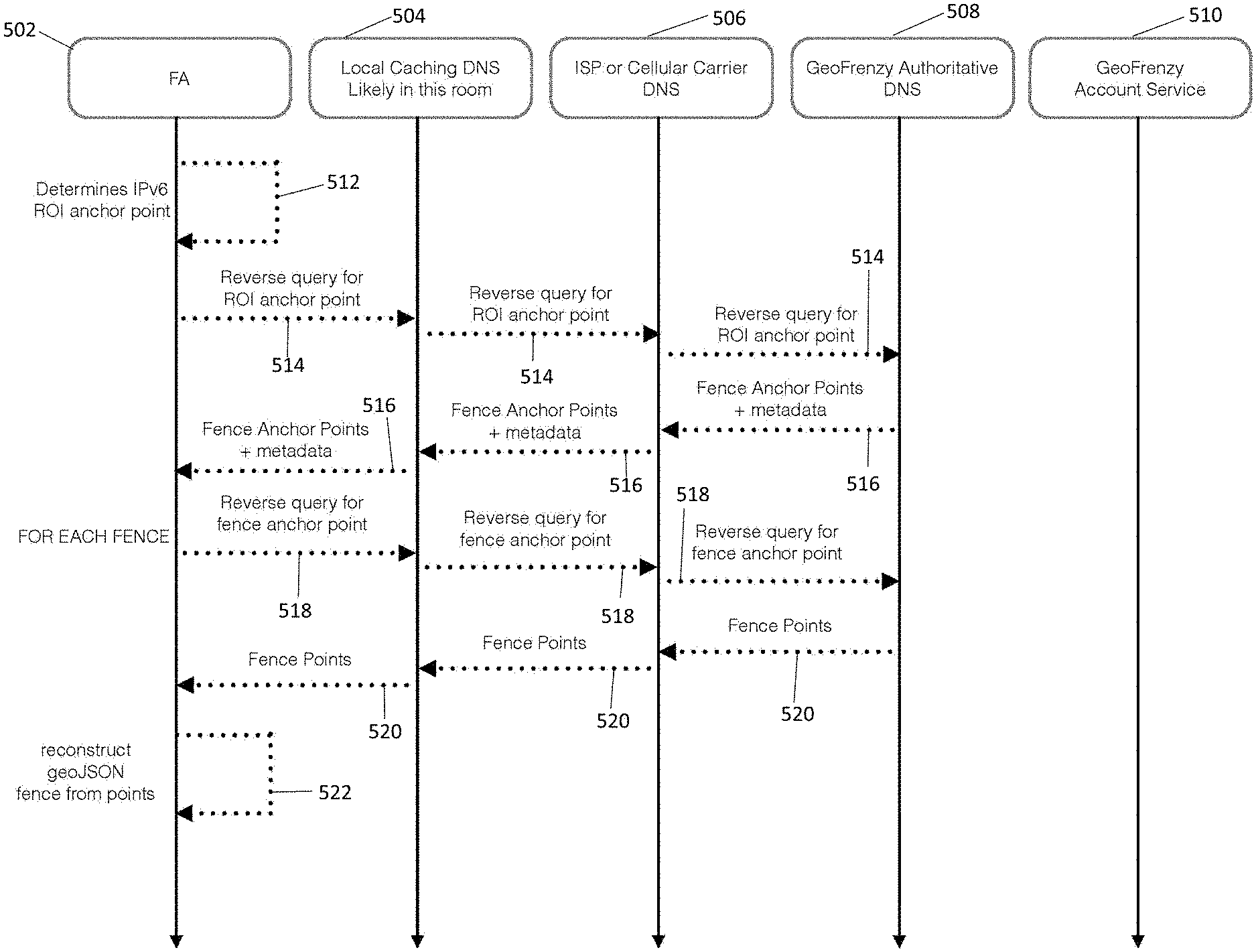
Geofence Efficient Lookup or Query by a Fencing Agent
As referenced in FIGS. 5A and 5B hereinbelow, stakeholders in the geofence registry systems and methods of the present invention use a web-based portal to configure their account's geofence, including identification of classes and/or entitlements; this configuration is stored on the at least one server or account server(s). On start-up, the fencing agent (FA) operable within the App pulls the configuration and validates its own signature with its own developer certificate. When the FA is initiated by its containing App, the Fence Delivery Network (FDN) lifecycle returns a set of fence points that my be translated by the FA into standard fence geometry such as geoJSON (polygon or centroid); upon receipt of a set of geofences, the FA automatically begins monitoring the geofences. Indications of classes and/or entitlements are also received by the FA within the App. The entitlements may indicate that proximity to a particular corresponding geofence provide for the geofence owner, operator or manager to request particular GPS power levels, FDN caching preferences, resolution, time of day restrictions, or to be promoted to a system level fence on the device's motion co-processor, which offloads monitoring for sleep state awakening. Upon approaching, entering, exiting, dwelling, or ranging to a geofence edge, the FA wakes or notifies the containing App with metadata including information for the geofence owner, class, signature, certification, and/or verification indications, validity date range or duration, and entitlements.
In the FDN query lifecycle, the mobile device automatically determines its own geolocation or position by operating system and GPS (i.e., its own lat/long); the FA converts the lat/long to an IPv6 geofence coordinate point (or point that is not a lat/long point); the FA determines the nearest anchor point for the region of interest (ROI); the FA sends reverse DNS query for the anchor point to at least one remote server via a network; the FA receives a DNS record including the anchor points of geofence(s) within the ROI, wherein the anchor points include metadata indicating ownership and use or intended use for the geofence(s) associated with the anchor point(s); the FA filters anchor points based upon subsequent queries and/or based upon grants of use extended to the FA through its developer certificate; the FA sends reverse DNS query for each of the filtered sets of geofence anchor points; the FA receives the DNS record(s) corresponding to and containing the constituent points of each geofence (polygon or centroid); and the FA converts the points to lat/long or other coordinate system in a geometry format for use by the mobile device operating system and Apps such as geoJSON.
For encoding of anchor points as IPv6 addresses, the range of available bits for metadata (64+ bits) compared with location data (0-63 bits) depends upon the size of IPv6 allocation, and the optimization of the metadata for zoom, as described hereinabove, such that changing the 64 bit boundary for location affects the zoom level or amount of metadata used for class, entitlements, and other geofence owner and intent for use information. The utility of IPv6 addresses for routing and Internet access will be achieved through the alignment of this zoom level/metadata boundary with IPv6 CIDR (classless inter-domain routing) and nibble boundries etc. For Internet of Things (IoT) applications, owners of geofences large enough to comprise enough IPv6 addresses to make an acceptable size router announcement, may announce and utilize their block of public address space, which assists IoT devices in discovery and self-provisioning, for example as described in use cases hereinabove.
Defining the Boundaries of the Geofences
There are many ways to define what constitutes a geofence under the present invention. Preferably, the geofence is defined using at least one geographic designator. Preferably, the geographic designator is a coordinate point or set of coordinate points. However, the geographic designator can be any identifying information for a geographic point, location, or area. In one embodiment, the geofence is defined by a series of coordinate points with lines connecting the series of points. The geofence is preferably a polygon in shape. In another embodiment, the geofence is an irregular shape. In a further embodiment, the geofence is a regular shape, such as a square, rectangle, triangle, circle, etc.
In one embodiment of the present invention, the geofences are defined by real property boundaries. Preferably, the real property boundaries are the boundaries defined by public records for the property. In another embodiment, the real property boundaries are user-defined. In one embodiment, the real property boundaries include public right of ways such as roads and sidewalks. In another embodiment, the real property boundaries do not include public right of ways. In one embodiment, the boundaries of the real property and/or the boundaries of the geofences are defined within between about 0.5 microns and about 3 meters. In another embodiment, the boundaries of the real property and/or the boundaries of the geofences are defined within between about 0.5 microns and 1 meter. In another embodiment, the boundaries of the real property and/or the boundaries of the geofences are defined within between about 0.5 microns and 30 centimeters. Preferably, the boundaries of the real property and/or the boundaries of the geofences are defined within between about 0.5 microns and 5 microns. Even more preferably, the boundaries of the real property and/or the boundaries of the geofences are defined within between about 0.5 microns and 1 micron. The precision, accuracy, and/or resolution of the boundaries is dependent upon the nature of the IP address used. Preferably, optimal precision, accuracy, and/or resolution is achieved using an IPv6 address.
In another embodiment, the geofences are defined by the perimeter of a structure, such as a house, an office building, an apartment, an apartment complex, a duplex, half of a duplex, a business, a hotel room, a rented space, or a recreational facility.
In yet another embodiment, the geofences are defined by city or town limits.
While most preferred embodiments of the present invention are noncentric or noncentroid geofences, or polygon geofences, alternative embodiments include centric or centroid geofences. Centric geofences are defined as the area within a certain radius of a beacon or other central point of reference.
In one embodiment of the present invention, the boundaries of the geofences are permanently defined. In yet another embodiment of the present invention, the boundaries of the geofences are temporary. Whether the boundaries of the geofences are permanent or temporary depends upon the nature of the property being geofenced. For example, geofences surrounding booths at trade shows, are preferably temporary because the booths themselves are temporary. Other examples of exemplary temporary geofences include hotel rooms, groups of hotel rooms, camp sites, and construction sites.
Another embodiment of the present invention includes systems and methods for updating the boundaries of a geofence. Preferably, the boundaries of a geofence are updated in a geofence database when the boundaries of the geofence are modified. In one embodiment, the boundaries of the geofence are automatically updated. In another embodiment, the boundaries of the geofence are updated by the owner of the geofence. In yet another embodiment, the boundaries of the geofence are updated by a licensee of the geofence.
Registering and Verifying a Geofence
The present invention includes a method and system for registering a geofence in the geofence database. In one embodiment, a method for registering the geofence includes inputting geographic designators defining a geofence, wherein each of the geographic designators are associated with an Internet Protocol (IP) address, inputting an owner name for the geofence, and submitting the geographic designators and owner name to a geofence database.
Another aspect of the present invention involves methods and systems for verifying the information in the database, including the boundaries of the geofences, the IP address associated with the geographic designators defining the geofences, contact information associated with the geofences, an owner associated with the geofences, licensees of the geofences, and combinations thereof. In one embodiment, an owner of the geofence verifies the information associated with that geofence. In another embodiment, a third party verifies the information associated with geofences.
Database of Geofences
In one embodiment of the present invention a method is provided with steps for creating a database of geofences, wherein the geofences in the database are associated with an IP address. Preferably, each geofence in the database is associated with at least one IP address. One embodiment involves defining the geofence by the boundaries of the geofence. In another embodiment, a set of individual coordinate points are listed along with a unique IP address associated with each set of individual coordinate points. Preferably, each set of coordinate points is associated with only one IP address. In one embodiment, the IP address is an IPv6 address. In another embodiment, the IP address is an IPv4 address. In yet another embodiment, the IP address is a future standard for determining IP addresses, such as IPv8 or IPvX.
The database of the present invention also preferably includes a plurality of other information associated with each geofence. Along with having the geofence, the geographic designators defining the geofence, and associated IP addresses, the geofence database of the present invention is operable to provide other useful information involved in the use of the geofences and corresponding IP addresses. For example, one embodiment of the present invention includes a geofence database with an owner name associated with the geofence. In another embodiment of the present invention, the owner contact information is associated with the owner name. The contact information preferably includes at least one of a phone number, an email address, and a mailing address. In another embodiment of the present invention, the database includes messaging functionality within the database itself, so that users can message other users and owners of geofences within the database platform. A country, city, town, postal code, street address, community, subdivision, township, other location defining information, and combinations thereof are preferably associated with the geofence in the database. The length of time that the geofence has been listed in the database is included in one embodiment of the present invention. Another embodiment of the present invention includes a length of time that the geofence has been verified in the database.
In one embodiment, a class associated with the geofence is listed in the database. Exemplary classes include residential, office, shopping malls, airports, arenas, train stations, and government buildings. Preferably, each class contains a plurality of subclasses that are optimized for zoom level, class, etc. Exemplary subclasses for arena use cases include concert arenas and sports arenas.
Licensees of the geofence (if any) are also preferably listed in association with each geofence within the geofence registry database. In the present invention, the term licensee refers to a person or entity who is granted a license (or entitlements) by the owner of the geofence to implement or have the opportunity to implement a license or entitlement to the geofence, to operate or manage the geofence, etc. Preferably, the licensee pays the owner of the geofence for the implementation and/or the opportunity for implementation. In one embodiment, users of devices within the geofence are bound by the entitlement or license automatically after entering the geofence. In another embodiment, users of devices within the geofence are bound by the entitlement or license after paying consideration. Preferably, the licensee obtains a license or an entitlement to the geofence in advance, or automatically via interactive licensing through Apps on the mobile device after discovery of the geofence(s), based upon the available entitlements and intended use of the geofence(s). In one embodiment use case, the entitlement includes a rule restricting content for devices located within the geofence. In another embodiment, the entitlement includes a rule enabling content for devices located within the geofence. In yet another embodiment, the entitlement includes a rule requiring content for devices located within the geofence. In one embodiment, the rule requiring content for devices located within the geofence depends upon a user of a device accepting an agreement for content to be displayed or installed on the device. In a further embodiment, the content is an advertisement. Preferably, the user is allowed to access additional content upon agreeing for the content to be displayed or installed on the device. Preferably, the entitlements are managed by a geofence entitlement manager, which is operable to activate the entitlement.
In one embodiment, App developers or app owners opt in for entitlements to be used in conjunction with their Apps.
There are many reasons licensees may wish to license a geofence and its corresponding IP addresses. By way of example, Gatorade is a corporate sponsor of the Atlantic Coast Conference (ACC). Therefore, Gatorade would probably prefer to block competitors' (such as Powerade) advertisements and offers at ACC events. Gatorade could therefore purchase a license to the geofence at the Dean Smith Center in Chapel Hill for beverage advertising. However, Geico, another corporate sponsor of the ACC, might also wish to advertise at the Dean Smith Center and block competitors' advertisements and offers. Since Gatorade and Geico are not direct competitors, each of them could purchase a license to advertise and block competitors' advertisements. In the geofence database, Gatorade would be listed as a licensee under a Beverages category whereas Geico would be listed as a licensee under an Insurance Provider category. Licensees are preferably grouped according to industry. If there is an opportunity to purchase a license for a particular geofence, this information is preferably listed in association with that geofence. Further information about the opportunity to purchase the license is preferably included as well, such as an asking price for the license, a duration for the license, a history of past licensees, and combinations thereof. In one embodiment, the licenses are exclusive license. Preferably the license is exclusive for one industry. In another embodiment, only one licensee is associated with the geofence. In another embodiment, the license is a nonexclusive license.
Notwithstanding present day rules by FCC regarding net neutrality, the present invention also provides for advertising services which redirect devices from requested content to content defined by an owner or a licensee of the geofence. In one embodiment, a licensee or owner creates a rule that dictates what content is displayed in response to a user's Internet search on a device inside the geofence. Preferably, the rule is embodied as an entitlement in the present invention. The dictation of the content may determine what content is restricted from being accessed via the Internet within the geofence, as well as what content appears first in response to an Internet search. For example, if Coca Cola is the licensee of a geofence, Coca Cola would create a rule which states that any Internet searches for Pepsi do not display results associated with Pepsi, but only results associated with Coca Cola products. Additionally, in another embodiment, a rule is established that any attempts to reach a certain company's website are redirected to the website of the owner licensee or owner. For example, if Coca Cola is the licensee of a geofence, any attempts to access Pepsi's website are redirected to Coca Cola's website. In one embodiment, the licensee pays the owner each time Internet search results are redirected and/or each time attempts to reach a company's website are redirected to the licensee's website. In another embodiment, the user of a device can opt out of receiving certain advertisements or having searches redirected by paying a fee. Yet another embodiment of the present invention restricts the usage of certain applications or apps within the geofence. Another embodiment requires the usage of certain applications, apps, or content within the geofence as a condition to the device performing an action within the geofence.
One embodiment of the present invention provides a method for renting or buying various rights associated with the geofences and/or the IP addresses associated with the geofences. In another embodiment of the present invention, the geofence is listed for sale or rent in the database. For example, the NY Yankees may wish to sale outright their geofence rights associated with Yankee Stadium. The new owner would control the Internet rights, including Internet advertising rights, within Yankee Stadium. In another embodiment, the NY Yankees may only wish to rent the geofence rights associated with Yankee Stadium. The rights could be rented for any period of time. In one embodiment, the rights are rented for a term of years, a year, a month, a day, or even an hour. In another embodiment, the rights are rented for a season, a game, or even an inning. In one embodiment, the price of rental rights fluctuates based on the rental time period.
In a further embodiment, the rights to a geofence are operable to be bought on a per transaction basis by a pay-per-transaction licensee. In this embodiment, the pay-per-transaction licensee agrees to pay the owner or a licensee of the geofence for each transaction, i.e. each advertisement that is sent on their behalf and/or each advertisement or content that is blocked on their behalf. Preferably, the pay-per-transaction licensee submits desired rules to the owner of the geofence. In one embodiment, the pay-per-transaction licensee submits these rules to the owner of the geofence through the database. The owner of the geofence then accepts these rules and provides a rate on a per rule basis. In one embodiment, the pay-per-transaction licensee pays a retainer amount before the rules are applied. Each transaction that requires an amount to be paid is deducted from the retainer amount. In another embodiment, the pay-per-transaction licensee's rules are enforced via a credit arrangement, with the owner of the geofence sending the pay-per-transaction licensee a bill at predetermined or agreed time periods.
In another embodiment of the present invention, air rights are associated with the geofences. Air rights preferably include restrictions on drones and other flying machines in the airspace associated with the geofence.
Preferably, operational rules for the geofence are associated with each geofence in the database. The operational rules define the permissions and restrictions (or entitlements) on wireless activities within the geofences. In one embodiment, the permissions and restrictions (or entitlements) are determined by one or more licensees. In another embodiment, the permissions and restrictions are determined by the owner. In one embodiment, the permissions and restrictions are listed in the database so that they are visible to users of the database. In another embodiment, only certain user-selected permissions and restrictions (or entitlements) are listed in the database so that they are visible to users of the database.
In one embodiment of the present invention, the geofence database is updated at predetermined time intervals. Preferably, the geofence database is automatically updated. Another embodiment of the present invention provides for manually or automatically updating ownership and/or licensee information upon a new ownership and/or license agreement.
Preferably, the database is sortable by location, class, verified or nonverified status, owner, licensee, email address, and combinations thereof.
In another embodiment, the database is searchable. Preferably, all fields displayed to users of the database are searchable, including fields relating to location, class, verified or nonverified status, owner, licensee, email address, and combinations thereof. Additionally, preferably a search option exists for a user of the database to search for all geofences within a certain distance of a location. Preferably, a feature of the database includes an option to display all geofences within a certain distance of the user's current location.
In a further embodiment, the invention provides a WiFi finder app to be used on a device in conjunction with the geofence database. Preferably, the WiFi finder app searches the geofence database and finds WiFi access points located near a location. In one embodiment, the location is the current location of the device. Preferably, the device is a mobile device. In a further embodiment, the device automatically searches for WiFi access points located near the location of the device.
In one embodiment, the database is accessible through a computer. In another embodiment, the database is accessible through a mobile phone. Preferably, the database is accessible through an app on the mobile phone.
Electronic Device Preferences
One embodiment of the present invention involves creating a list of device preferences within the geofence database. Preferably, the device preferences include information relating to the device and the user of the device, including demographic characteristics such as age, sex, and family status as well as preferences for certain products or services. Preferably, the preferences for certain products or services are preferences that stretch across industries. In one embodiment, the licensee pays a fee to obtain access to preferences that are not within the licensee's business or industry. By way of example, if Coca Cola is the owner or licensee of the Yankee Stadium geofence, it desires to maximize the sale of all its brands. Thus, instead of sending generic Coca Cola advertisements to all users in the geofence, device and user preferences would dictate which brand advertisements are sent to which user(s). A young mother or a user who has indicated a preference for Minute Maid juice would be more likely to receive an advertisement for Minute Maid instead of Coca Cola. Someone who has expressed a preference for health products would be more likely to receive advertisements for vitamin enhanced water, or another "healthier" brand of Coca Cola.
In another embodiment of the present invention, a list of devices permitted to access the Internet within a geofence is associated with the geofence in the geofence database. An administrator, owner, or licensee of the geofence grants access in one embodiment. In another embodiment, a user of a device requests access and access is automatically granted based on the user's acceptance of an agreement or terms relating to the access. In another embodiment, a list of devices prohibited from accessing the Internet within a geofence is associated with the geofence. In a further embodiment, the database of the present invention is updated in real-time or near real-time and includes a list of the number and identity of devices currently using the Internet within the geofence. In another embodiment, the database includes a list of the number and identity of devices that have used the Internet within a predetermined time period, such as the last hour, last day, last week, or last year.
Analytics
One embodiment of the present invention relates to providing analytics for geofences and the corresponding IP addresses. Preferably, the analytics are accessible through the database. In one embodiment, analytics include determining a number of devices which have accessed and/or attempted to access the Internet within a geofence for a particular time period or overall. Another embodiment includes determining the number of advertisements that have been sent to devices within the geofence. Preferably, the number of advertisements is further sorted into the number of advertisements sent on behalf of the owner and licensees. The number of advertisements preferably includes a breakdown of the number of each type of advertisement sent and the number of a particular advertisement sent. Additionally, the present invention provides for analytics relating to the number of advertisements blocked within the geofence and/or the number of redirected searches within the geofence. In another embodiment, the present invention includes statistics relating to the volume of sales of a product or service within the geofence. Preferably, the product or service is a product or service sold by the owner or licensee of the geofence. In another embodiment, the product or service is a product or service sold by the competitor of the owner or licensee of the geofence. In another embodiment of the present invention, the analytics include analytics relating to the number of offers distributed by a licensee or owner of the geofence and the number of those offers accepted by users of devices within the geofence. In yet another embodiment of the present invention, the analytics include analytics relating to how many times individual devices have entered the geofence, an average duration for the time spent by the device in the geofence, and combinations thereof.
Geofence Classes
Geofences are created to serve different intents with different functionalities. Geofences can be created for residential properties with control and management and surveillance functionality. In one embodiment, such a geofence will block drones flying across into the territory of this residential property. In another embodiment, vehicles equipped with communication systems, when entering or leaving the residential property geofence, will trigger a notification to the owner. In yet another embodiment, people with mobile devices can trigger notifications to the owner as well so that the owner knows who they are, friends, relatives, neighbors, or intruders.
Geofences can also be created at business locales for fair competition and management. In one embodiment, customers in a first pizza shop cannot receive advertisements or coupons from a second pizza shop across the street due the control of the geofence for the first pizza shop.
Geofences can also be created for public or private schools for the purpose of protection. In one embodiment, unwanted information and advertisements are block out of the school territory for the safety reason. In another embodiment, a school geofence can recognize unauthorized persons entering the geofence if there is a mobile device with them so as to take further actions.
Although geofences have traditionally been stationary, a strong need exists for creating mobile geofences. These geofences are defined as a polygon or a shape around a mobile object, such as a vehicle, plane, or boat. Additionally, the mobile geofences are defined centrally with respect to the object, by a beacon or other indicator located in the object in one embodiment. Rules for mobile geofences preferably relate to advertising within the mobile geofences. In one embodiment, rules for the mobile geofences relate to functionalities of devices within the mobile geofences. In one embodiment, a rule prohibits text messaging within a mobile geofence around a vehicle. Another example of an embodiment prohibits advertising by a competitor. An example would be prohibiting advertisements relating to a competitor's cruise ship within the mobile geofence of a particular cruise ship.
A further embodiment of the present invention includes permanently prohibiting advertising in a mobile geofence based on a brand of the mobile object. For example, a Toyota would include a mobile geofence which prohibits advertising by Ford, Chevrolet, BMW, etc. within the Toyota.
Geofences can also be created on certain highway sections, busy intersections, and high accident locations for safety management. In one embodiment, when moving vehicles are within such geofences, all the mobile device are disabled for texting, website browsing, calling except emergency calls.
Preferably, vehicle makers and application developers opt in geofence functionalities as a standard to provide customers safer and more flexible experiences.
Fence Delivery Network
Fundamentally, the present invention relies on a coordinate system based on IP addresses, where an IP address, preferably an IPv6 address, is used to describe an exact point on earth on micron level. Traditionally, a coordinate point with a longitude value and a latitude value is used to describe a geographic point on earth. However, with the present invention, an IP address is also associated with a geographic point. The IP address and coordinate point can be converted to each other for related lookups. Preferably, the IPv6 address is only used to determine the anchor point associated with the geofence(s). A single anchor point is computed independently when the lat/long is automatically converted to an IPv6 address for the ROI anchor point; this is the only time the IPv6 address is used within the systems and methods of the present invention. The constituent points of fence geometry are also expressed in IP addresses. The ROI anchor and fence anchor are the only uses of DNS queries.
A method for querying a database of registered geofences is disclosed. A request associated with an IP address is received by a server/processor. The IP address is converted to an anchor point of geographic location within the ROI in the processor. One or more geofences having respective geographic areas that overlap with the anchor point identified. The request is a DNS query and accordingly, the response a DNS response. Information describing the identified geofences is encoded in the IP addresses and the list of fence IP address points are returned in the DNS response. The information includes an indication whether a particular geofence is verified or unverified, a class of the identified geofence, an entitlement of the geofence, a time-to-live value related to the geofence, and metes and bounds of the geofence, which together provide the information about the registered geofence and its intended use(s) as registered by the owner of the geofence (i.e., the entitlements provide the intended use information).
In one embodiment, a user device is location-aware, which means that a user device is able to determine its own location by use of relevant technology, such as GPS, iBeacon, WiFi and etc. The user device independently converts a coordinate point describing its location (lat/long automatically determined by the device location services) to an IP address, preferably IPv6 address.
A fence delivery network comprises a server and one or more geofence databases communicating over network with a fencing agent (FA) contained within or operable within an App on a device (or otherwise programmed for operation on the mobile device). A geocoder module or an IP-Coordinate converter in the server performs the conversion between an IP address to a coordinate point of a geographic location. A search/query module in the server queries one or more geofence databases. The one or more databases can be centralized or decentralized. This fence delivery network a very robust system that supplies every internet connected device with IP/Coordinate and Coordinate/IP mappings in a very distributed, redundant and fault tolerant way.
Visualization
A Graphical User Interface is used for geofence registration, lookup and permissions.
Registration GUI
According to one embodiment of the present invention, a user registers a geofence via a geofence registration GUI. Preferably, the geofence GUI includes a map. In one embodiment, the user defines the geofence on the map. In a further embodiment, the user defines the geofence on the map by outlining the perimeter of the geofence on the map. In another embodiment, the user defines the geofence on the map by indicating the location and the range of the beacon on the map. In yet another embodiment, the user enters a street address associated with a geofence and the associated real property boundaries of the geofence are automatically drawn onto the map.
Lookup and Permission GUI
With a geofence query GUI, a user can search on metadata and certificate details, since neither the stakeholders using the GUI nor the app developers are aware of the IP addresses. There is another button "geofence search", it will pull up all the identified geofences related to the IP address and the associated geofence information. Search terms like "verified, active, Amazon, drone, barking" (by way of example and not limitation) would yield a set of fences with a visual depiction of their geometry on the map.
There is also a 2D interactive map, it shows the boundary of each identified geofence and a label indicating some of the geofence information, such as verified or unverified, entitled or not, and a summary of the data content within the geofence. This 2D interactive map provides a visual overlay or comparison of IPv6 addresses and geographic coordinate points with high resolution. In other embodiments, a 3D interactive map may be used to provide for global coverage.
In one embodiment, the map of geofences is color coded. Preferably, geofences are coded by color according to at least one of a class, a permanent or temporary status, an owner status, a licensee status, usage statistics, verification status, precedence, etc. In one embodiment, the map is accessible via a mobile device. In a further embodiment, the map is operable to be accessed and manipulated using a touch screen. In one embodiment, a user clicks on an area on the map associated with a geofence to request access to the geofence.
In one embodiment, a desktop computer with internet connection can be used to perform the query via this GUI. In another (preferred) embodiment, a mobile device with an application installed is used to perform the query. In this embodiment, there may be a "connect" or "enter" button for a geofence. Once the mobile device will have interactions with the selected.
Messaging/Notification
One embodiment is that a user/a user's mobile device searches available geofences and related information, and then the user selects which one he wants to connect or enter. Once the user hits "enter" button for a specific geofence, there will be interaction between the mobile device and the specific geofence server.
There may be "terms and conditions" for the geofence entrance, for example, that geofence server has access to your mobile device and collect data, certain laws and rules are enforced within the geofence, and etc. Geofences may be free or fee required to enter. If there is a certain fee, payment page is transmitted to the mobile device. Once the user accepts the terms and conditions and pays the fee if required, the user/mobile device is allowed to enter the geofence via a notification. This way, the user/mobile device can receive information this specific geofence has. There may be different levels of fees and bases on the fee level, based on the fee level, there are different levels of information access for the users, such as basic, premium, enterprise and etc. A user/mobile device may enter more than one geofence at the same time. There are entrance procedures similar to the above description.
Another embodiment is that once the user/a user's mobile device physically is within certain geofences, there are notifications popping up, similar to the wifi alert on the user's mobile device if the WiFi is on. At this time, the user/mobile device can still query the geofence database to get more information about the available geofences and then decides which geofence(s) to enter.
In another embodiment, the mobile device may be admitted to certain geofences automatically once it is within the boundary of those geofences. In some circumstances, the user/mobile device may receive unwanted advertisements or other annoying information or services, the user has the option to exit or block those geofences, or block receiving certain information. Preferably, the fence delivery network application installed mobile device can identify "obnoxious" or unsecure or junk geofences and display warnings or notifications to the user as a kind of location-based service.
DETAILED DESCRIPTION OF THE FIGURES
Referring now to the figures, they are provided for illustration of the present invention and are not intended to limit the claims thereto.
FIG. 1 is a schematic diagram of an embodiment of the invention illustrating a computer system, generally described as 800, having a network 810, a plurality of computing devices 820, 830, 840, a server 850 and a database 870.
The server 850 is constructed, configured and coupled to enable communication over a network 810 with a computing devices 820, 830, 840. The server 850 includes a processing unit 851 with an operating system 852. The operating system 852 enables the server 850 to communicate through network 810 with the remote, distributed user devices. Database 870 may house an operating system 872, memory 874, and programs 876.
In one embodiment of the invention, the system 800 includes a cloud-based network 810 for distributed communication via a wireless communication antenna 812 and processing by a plurality of mobile communication computing devices 830. In another embodiment of the invention, the system 800 is a virtualized computing system capable of executing any or all aspects of software and/or application components presented herein on the computing devices 820, 830, 840. In certain aspects, the computer system 800 may be implemented using hardware or a combination of software and hardware, either in a dedicated computing device, or integrated into another entity, or distributed across multiple entities or computing devices.
By way of example, and not limitation, the computing devices 820, 830, 840 are intended to represent various forms of digital computers 820, 840, 850 and mobile devices 830, such as a server, blade server, mainframe, mobile phone, a personal digital assistant (PDA), a smart phone, a desktop computer, a netbook computer, a tablet computer, a workstation, a laptop, and other similar computing devices. The components shown here, their connections and relationships, and their functions, are meant to be exemplary only, and are not meant to limit implementations of the invention described and/or claimed in this document
In one embodiment, the computing device 820 includes components such as a processor 860, a system memory 862 having a random access memory (RAM) 864 and a read-only memory (ROM) 866, and a system bus 868 that couples the memory 862 to the processor 860. In another embodiment, the computing device 830 may additionally include components such as a storage device 890 for storing the operating system 892 and one or more application programs 894, a network interface unit 896, and/or an input/output controller 898. Each of the components may be coupled to each other through at least one bus 868. The input/output controller 898 may receive and process input from, or provide output to, a number of other devices 899, including, but not limited to, alphanumeric input devices, mice, electronic styluses, display units, touch screens, signal generation devices (e.g., speakers) or printers.
By way of example, and not limitation, the processor 860 may be a general-purpose microprocessor (e.g., a central processing unit (CPU)), a graphics processing unit (GPU), a microcontroller, a Digital Signal Processor (DSP), an Application Specific Integrated Circuit (ASIC), a Field Programmable Gate Array (FPGA), a Programmable Logic Device (PLD), a controller, a state machine, gated or transistor logic, discrete hardware components, or any other suitable entity or combinations thereof that can perform calculations, process instructions for execution, and/or other manipulations of information.
In another implementation, shown as 840 in FIG. ##, multiple processors 860 and/or multiple buses 868 may be used, as appropriate, along with multiple memories 862 of multiple types (e.g., a combination of a DSP and a microprocessor, a plurality of microprocessors, one or more microprocessors in conjunction with a DSP core).
Also, multiple computing devices may be connected, with each device providing portions of the necessary operations (e.g., a server bank, a group of blade servers, or a multi-processor system). Alternatively, some steps or methods may be performed by circuitry that is specific to a given function.
According to various embodiments, the computer system 800 may operate in a networked environment using logical connections to local and/or remote computing devices 820, 830, 840, 850 through a network 810. A computing device 830 may connect to a network 810 through a network interface unit 896 connected to the bus 868. Computing devices may communicate communication media through wired networks, direct-wired connections or wirelessly such as acoustic, RF or infrared through an antenna 897 in communication with the network antenna 812 and the network interface unit 896, which may include digital signal processing circuitry when necessary. The network interface unit 896 may provide for communications under various modes or protocols.
In one or more exemplary aspects, the instructions may be implemented in hardware, software, firmware, or any combinations thereof. A computer readable medium may provide volatile or non-volatile storage for one or more sets of instructions, such as operating systems, data structures, program modules, applications or other data embodying any one or more of the methodologies or functions described herein. The computer readable medium may include the memory 862, the processor 860, and/or the storage media 890 and may be a single medium or multiple media (e.g., a centralized or distributed computer system) that store the one or more sets of instructions 900. Non-transitory computer readable media includes all computer readable media, with the sole exception being a transitory, propagating signal per se. The instructions 900 may further be transmitted or received over the network 810 via the network interface unit 896 as communication media, which may include a modulated data signal such as a carrier wave or other transport mechanism and includes any delivery media. The term "modulated data signal" means a signal that has one or more of its characteristics changed or set in a manner as to encode information in the signal.
Storage devices 890 and memory 862 include, but are not limited to, volatile and non-volatile media such as cache, RAM, ROM, EPROM, EEPROM, FLASH memory or other solid state memory technology, disks or discs (e.g., digital versatile disks (DVD), HD-DVD, BLU-RAY, compact disc (CD), CD-ROM, floppy disc) or other optical storage, magnetic cassettes, magnetic tape, magnetic disk storage or other magnetic storage devices, or any other medium that can be used to store the computer readable instructions and which can be accessed by the computer system 800.
It is also contemplated that the computer system 800 may not include all of the components shown in FIG. 1, may include other components that are not explicitly shown in FIG. 1, or may utilize an architecture completely different than that shown in FIG. 1. The various illustrative logical blocks, modules, elements, circuits, and algorithms described in connection with the embodiments disclosed herein may be implemented as electronic hardware, computer software, or combinations of both. To clearly illustrate this interchangeability of hardware and software, various illustrative components, blocks, modules, circuits, and steps have been described above generally in terms of their functionality. Whether such functionality is implemented as hardware or software depends upon the particular application and design constraints imposed on the overall system. Skilled artisans may implement the described functionality in varying ways for each particular application (e.g., arranged in a different order or partitioned in a different way), but such implementation decisions should not be interpreted as causing a departure from the scope of the present invention.
FIG. 2 is a flowchart for delivering geofence information based on a request. A user send out a DNS request associated with an IP address 202. A server converts the IP address to a coordinate point of geographic location and query a geofence database 204. Then one or more geofences overlapping at the coordinate point are identified 206. The server then returns a DNS response including information describing the identified one or more geofences 208.
FIG. 3 is an embodiment of GUI for the geofence delivery network. A user can enter latitude and longitude values in a box on the GUI 302, then selects the button "Geofence search" 304. Then, all the identified geofences are identified and listed on the GUI with corresponding information 306. There is also an interactive map displaying the identified geofences 308. In this illustrated example, there are three geofences identified. Their name, class, entitlement, verification, and content information are displayed accordingly. In the interactive map, boundaries of the three geofences G1 (black) 310, G2 (green) 312, and G3 (red) 314 are differentiated with different line types. Meanwhile, the converted coordinate point 316 is also noted in the map.
FIG. 4 illustrates one embodiment of a GUI for fence delivery network 402, including several options of defining a geofence, including defining the geofence by real property boundaries, defining the geofence by the radius around a beacon, defining the geofence by the perimeter of a building. By way of example and not limitation, a use case for identifying geofences associated with Dog Parks is shown, indicating the locations of the Dog Parks 404 based upon the City of SF, and public use hours and restrictions 406 are also indicated. Also illustrated are My Fences, which in this use case include the user's home geofence (My House) 408 and Fire Hydrants 410 are also identified. All of these are automatically indicated with geographic proximity to each other and visually represented in 2-D map view on the GUI of the user's mobile device.
FIGS. 5A & 5B show a flowchart illustrating steps for querying a geofence database. The FIG. 5A flowchart includes an FA 502, a Local Caching DNS 504, an ISP or Cellular Carrier DNS 506, a GeoFrenzy Authoritative DNS 508, and a GeoFrenzy Authoritative Account Service 510. Steps include determines IPv6 ROI anchor point 512, Reverse query for ROI anchor point 514, Fence Anchor Points+metadata 516, Reverse query for fence anchor point 518, Fence Points 520, and reconstruct geoJSON fence from points 522. FIG. 5B is a cached response for steps for querying a geofence database.
FIG. 6 is a diagram illustrating zoom level to class binding when using a pyramid projection 600. As shown, Drones are provided on a zoom level 9-14 602; Pet Tracker is provided on a zoom level 17 604; and Hotel Room HVAC/Lighting is provided on a zoom level 25 606. In a current pyramid projection according to the present invention, the highest order bits of IP addresses are used to represent a location the lower order bits are used to express metadata such as fence classes, entitlements, and lookup table identifiers (for the purpose of redefining the metadata bits in the future). In other embodiments, the metadata can be expressed on any aspect of DNS or IP, such as DNS RR (resource records), certificates, keys or IPv6 scopes. In a current pyramid projection according to the present invention, there are trillions of potential bits to be used as metadata in every square millimeter of location. These bits, when set to 1 will represent an intersection of class, entitlements and lookup table for this square centimeter location.
FIG. 7 illustrates a 3-D model overview illustrating how the surface of the Earth is not a perfect sphere 702; however, as provided by the present invention, a sphere map is generated automatically consisting of points that are represented by IPv6 addresses that superficially wrap around or cover the Earth such that the sphere map encompasses the highest features to represent or approximate the Earth's surface for use with the present invention generation of geofences registry, lookup, categorization within at least one database for geofences.
FIG. 8 is a 2-D model overview illustrating another view of mapping the earth 706 for providing visualization of geofences according to the present invention.
FIG. 9 is a PRIOR ART schematic diagram for geofencing solutions. Current prior art geofencing solutions are generally based on centroid fences and the data emitted by the location service frameworks consists of simple messages containing the fence identification (ID) and a notice of entry 902, exit 904, or dwelling 906 inside of the fence 900.
FIG. 10 is a schematic diagram for geofencing solutions according to the present invention. By contrast and differentiation from prior art, the present invention provides for augmentation of messaging. The approaching 920, entering 902, exiting 904, and dwelling 906 messages are augmented with metadata describing the ownership and purpose of a geofence through a hierarchy of classes 922. The purpose of a geofence is defined to include the intended and/or allowed use of services inside or within the geofence boundaries, which are expressed through a system of entitlements that are received as inputs and stored in the at least one geofence database and associated with the geofence data.
FIG. 11 is a schematic diagram illustrating the encoding of a class and entitlement on an IPv6 address. While this illustration is oversimplified, its depiction of encoding of a class and entitlement on an IPv6 address may be extended to provide for billions of positions per location. The lat/long point 1102 is the edge of a floating bit boundary; the dots 1104 represent the anchor points that the systems and methods of the present invention use for metadata rather than for location. The neighboring lat/long point 1105 is the next usable point under which the depicted and described process starts again (or repeats). Significantly, there is only one bit of metadata for each anchor point, but there can be multiple points for each geofence, according to the present invention; this provides for and allows multiple classes and/or entitlements to be expressed and associated with each geofence. In the example case used for this FIG. 11, four example entitlements are illustrated: Notification 1106, Drone Landing 1108, Connect VPN 1110, and Camera 1112; they have corresponding colorized points, respectively: red, green, yellow, and blue. The example case is provided for illustration purposes only, and does not intend to limit the claimed invention thereto; the example case shows a user (Jenny/Jenny's Flowers) 1114 who would like to allow delivery drones to land for pickup and dropoff inside a predetermined geofence having an anchor point at lat/long as illustrated. Each point is a neighboring lat/long point; Owner 1 1116, Owner 2 1118, Bob's Tacos 1120, Jenny's Flowers 1114, and John Jones 1122 are all indicated in this example as geofence owners; Class 1 1124, Class 2 1126, Flower Shops 1128, and John's house 1130 are all indicated as geofence classes associated with the indicated example entitlements. The green point activated for Jenny's Flowers user/owner and for Flower Shops 1132 that allows for the entitlement of Drone Landing (green point) is highlighted to indicate an intended or allowable use of that geofence by the geofence owner.
By way of definition and description supporting the claimed subject matter, preferably, the present invention includes communication methodologies for transmitting data, data packets, messages or messaging via a communication layer. Wireless communications over a network are preferred. Correspondingly, and consistent with the communication methodologies for transmitting data or messaging according to the present invention, as used throughout this specification, figures and claims, wireless communication is provided by any reasonable protocol or approach, by way of example and not limitation, Bluetooth, Wi-Fi, cellular, zigbee, near field communication, and the like; the term "ZigBee" refers to any wireless communication protocol adopted by the Institute of Electronics & Electrical Engineers (IEEE) according to standard 802.15.4 or any successor standard(s), the term "Wi-Fi" refers to any communication protocol adopted by the IEEE under standard 802.11 or any successor standard(s), the term "WiMax" refers to any communication protocol adopted by the IEEE under standard 802.16 or any successor standard(s), and the term "Bluetooth" refers to any short-range communication protocol implementing IEEE standard 802.15.1 or any successor standard(s). Additionally or alternatively to WiMax, other communications protocols may be used, including but not limited to a "1G" wireless protocol such as analog wireless transmission, first generation standards based (IEEE, ITU or other recognized world communications standard), a "2G" standards based protocol such as "EDGE or CDMA 2000 also known as 1XRTT", a 3G based standard such as "High Speed Packet Access (HSPA) or Evolution for Data Only (EVDO), any accepted 4G standard such as "IEEE, ITU standards that include WiMax, Long Term Evolution "LTE" and its derivative standards, any Ethernet solution wireless or wired, or any proprietary wireless or power line carrier standards that communicate to a client device or any controllable device that sends and receives an IP based message. The term "High Speed Packet Data Access (HSPA)" refers to any communication protocol adopted by the International Telecommunication Union (ITU) or another mobile telecommunications standards body referring to the evolution of the Global System for Mobile Communications (GSM) standard beyond its third generation Universal Mobile Telecommunications System (UMTS) protocols. The term "Long Term Evolution (LTE)" refers to any communication protocol adopted by the ITU or another mobile telecommunications standards body referring to the evolution of GSM-based networks to voice, video and data standards anticipated to be replacement protocols for HSPA. The term "Code Division Multiple Access (CDMA) Evolution Date-Optimized (EVDO) Revision A (CDMA EVDO Rev. A)" refers to the communication protocol adopted by the ITU under standard number TIA-856 Rev. A.
It will be appreciated that embodiments of the invention described herein may be comprised of one or more conventional processors and unique stored program instructions that control the one or more processors to implement, in conjunction with certain non-processor circuits, some, most, or all of the functions for the systems and methods as described herein. The non-processor circuits may include, but are not limited to, radio receivers, radio transmitters, antennas, modems, signal drivers, clock circuits, power source circuits, relays, current sensors, and user input devices. As such, these functions may be interpreted as steps of a method to distribute information and control signals between devices. Alternatively, some or all functions could be implemented by a state machine that has no stored program instructions, or in one or more application specific integrated circuits (ASICs), in which each function or some combinations of functions are implemented as custom logic. Of course, a combination of the two approaches could be used. Thus, methods and means for these functions have been described herein. Further, it is expected that one of ordinary skill in the art, notwithstanding possibly significant effort and many design choices motivated by, for example, available time, current technology, and economic considerations, when guided by the concepts and principles disclosed herein, will be readily capable of generating such software instructions, programs and integrated circuits (ICs), and appropriately arranging and functionally integrating such non-processor circuits, without undue experimentation.
Certain modifications and improvements will occur to those skilled in the art upon a reading of the foregoing description. The above-mentioned examples are provided to serve the purpose of clarifying the aspects of the invention and it will be apparent to one skilled in the art that they do not serve to limit the scope of the invention. All modifications and improvements have been deleted herein for the sake of conciseness and readability but are properly within the scope of the present invention.
* * * * *
D00000
D00001
D00002
D00003
D00004
D00005
D00006
D00007
D00008
D00009
D00010
D00011
D00012

XML
uspto.report is an independent third-party trademark research tool that is not affiliated, endorsed, or sponsored by the United States Patent and Trademark Office (USPTO) or any other governmental organization. The information provided by uspto.report is based on publicly available data at the time of writing and is intended for informational purposes only.
While we strive to provide accurate and up-to-date information, we do not guarantee the accuracy, completeness, reliability, or suitability of the information displayed on this site. The use of this site is at your own risk. Any reliance you place on such information is therefore strictly at your own risk.
All official trademark data, including owner information, should be verified by visiting the official USPTO website at www.uspto.gov. This site is not intended to replace professional legal advice and should not be used as a substitute for consulting with a legal professional who is knowledgeable about trademark law.