Systems and methods for roadside assistance
Chen , et al. Feb
U.S. patent number 10,560,823 [Application Number 16/152,739] was granted by the patent office on 2020-02-11 for systems and methods for roadside assistance. This patent grant is currently assigned to Allstate Insurance Company. The grantee listed for this patent is Allstate Insurance Company. Invention is credited to Rodolfo Roberto Ballesteros, Tao Chen, Stephen Robert Newell, Manjunath Rao, Umamaheshwar R. Uppada.


View All Diagrams
| United States Patent | 10,560,823 |
| Chen , et al. | February 11, 2020 |
Systems and methods for roadside assistance
Abstract
Systems and methods in accordance with embodiments of the invention can proactively determine if an individual is likely in need of roadside assistance. Information can be collected from the individual's phone, including the person's location, the type of road, and/or ambient noise. If it is determined that the individual likely needs roadside assistance, the system can proactively contact the individual to see if roadside assistance is desired, and if so, initiates roadside assistance. The system also can provide helpful information, such as safety information, and/or automatically contact other individuals to alert them of the roadside event and the location of the individual.
| Inventors: | Chen; Tao (Northbrook, IL), Rao; Manjunath (Hoffman Estates, IL), Uppada; Umamaheshwar R. (Palatine, IL), Ballesteros; Rodolfo Roberto (Aurora, IL), Newell; Stephen Robert (Belfast, GB) | ||||||||||
|---|---|---|---|---|---|---|---|---|---|---|---|
| Applicant: |
|
||||||||||
| Assignee: | Allstate Insurance Company
(Northbrook, IL) |
||||||||||
| Family ID: | 69410816 | ||||||||||
| Appl. No.: | 16/152,739 | ||||||||||
| Filed: | October 5, 2018 |
| Current U.S. Class: | 1/1 |
| Current CPC Class: | H04W 84/00 (20130101); H04B 1/3805 (20130101); H04W 4/44 (20180201); H04B 1/3822 (20130101); G07C 5/0816 (20130101); G08G 1/127 (20130101); G07C 5/008 (20130101) |
| Current International Class: | H04W 4/44 (20180101); G08G 1/127 (20060101); G07C 5/08 (20060101); G07C 5/00 (20060101) |
References Cited [Referenced By]
U.S. Patent Documents
| 7119669 | October 2006 | Lundsgaard et al. |
| 8019629 | September 2011 | Medina, III et al. |
| 8332242 | December 2012 | Medina, III |
| 8862092 | October 2014 | Reitnour |
| 9581461 | February 2017 | Chintakindi et al. |
| 9767625 | September 2017 | Snyder et al. |
| 9773281 | September 2017 | Hanson |
| 9818239 | November 2017 | Pal et al. |
| 9832241 | November 2017 | Hayward |
| 9955319 | April 2018 | Matus et al. |
| 2002/0016667 | February 2002 | Baur et al. |
| 2003/0060977 | March 2003 | Jijina et al. |
| 2008/0082261 | April 2008 | Tengler et al. |
| 2009/0271325 | October 2009 | Wilson |
| 2012/0123806 | May 2012 | Schumann, Jr. |
| 2012/0166229 | June 2012 | Collins et al. |
| 2013/0069802 | March 2013 | Foghel et al. |
| 2013/0226441 | August 2013 | Horita |
| 2014/0062725 | March 2014 | Maston |
| 2014/0074402 | March 2014 | Hassib et al. |
| 2014/0266789 | September 2014 | Matus |
| 2015/0084757 | March 2015 | Annibale et al. |
| 2015/0127388 | May 2015 | Oldham |
| 2016/0086285 | March 2016 | Peters et al. |
| 2016/0104328 | April 2016 | Chen |
| 2016/0171521 | June 2016 | Ramirez et al. |
| 2016/0171621 | June 2016 | Bogovich et al. |
| 2017/0164158 | June 2017 | Watkins |
Other References
|
Feb. 2, 2017--(WO) International Search Report and Written Opinion--App PCT/US17/12016. cited by applicant . Feb. 6, 2017--(WO) International Search Report and Written Opinion--App PCT/US17/12029. cited by applicant . Kumar et al, Automatic Vehicle Accident Detection and Rescue System, International Journal for Research in Applied Science & Engineering Technology (IJRASET), vol. 4, Issue IV, Apr. 2016, p. 592-596. cited by applicant . Ali et al, Car Accident Detection and Notification System Using Smartphone, International Journal of Computer Science and Mobile Computing (IJCSMC), vol. 4, Issue 4, Apr. 2015, p. 620-635. cited by applicant . Saymum Ahmmed Sany et al, IoT Based Vehicle Accident Detection & Rescue Information System, Dept. of Computer Science & Engineering (CSE), East West University, Dhaka, Bangladesh, Aug. 2017, p. i-68. cited by applicant . Priyanga et al, Sensor Based Accident Detection and Prevention Technology, International Journal of Advanced Technology in Engineering and Science, vol. 2, Issue 11, Nov. 2014, p. 156-161. cited by applicant . Aug. 1, 2019 (EP) Extended Search Report--Application No. EP17736197.9. cited by applicant . Jul. 12, 2019--(EP) Extended Search Report--Application No. EP17736191. cited by applicant . Nov. 14, 2019--(WO) International Search Report & Written Opinion--PCT/US19/054540. cited by applicant. |
Primary Examiner: McCormack; Thomas S
Attorney, Agent or Firm: Banner & Witcoff, Ltd.
Claims
What is claimed is:
1. A method, comprising: obtaining vehicle state data describing an operational state of a vehicle using a mobile device, where the mobile device comprises a processor and a memory in communication with the processor; determining vehicle location data using the mobile device, where the vehicle location data describes the location of the vehicle; obtaining vehicle status data using the mobile device, wherein: the mobile device comprises a microphone; and the vehicle status data comprises audio data captured using the microphone and indicating a hazard signal within the vehicle having been activated; generating a vehicle event based on the vehicle state data, the vehicle location data, and the vehicle status data; obtaining notification data using the mobile device; and displaying the notification data using the mobile device.
2. The method of claim 1, wherein the vehicle state data further comprises accelerometer data obtained using an accelerometer in the mobile device.
3. The method of claim 1, wherein the vehicle location data determined using a global positioning system (GPS) receiver in the mobile device.
4. The method of claim 1, wherein obtaining the vehicle status data further comprises processing the vehicle status data to determine if the vehicle is located in an environment with moving traffic.
5. The method of claim 1, further comprising: identifying one or more feature vectors within the audio data using machine learning; and identifying one or more characteristics in the audio data utilizing the feature vectors.
6. The method of claim 1, wherein generating a vehicle event further comprises utilizing a risk map and the vehicle location data to determine if the vehicle is stopped in a dangerous area.
7. The method of claim 1, further comprising: obtain user input based on the displayed notification data using the mobile device; and initiating a request for roadside assistance based on the obtained user input.
8. The method of claim 1, further comprising: obtaining user input based on the displayed notification data using the mobile device; obtaining a selection of a contact using the mobile device; and providing a notification related to the vehicle event to the selected contact using the mobile device.
9. A system, comprising: a microphone; a processor; and a memory in communication with the processor, the memory including instructions that, when executed by the processor, cause the processor to: obtain vehicle state data describing an operational state of a vehicle; determine vehicle location data describing the location of the vehicle; obtain vehicle status data, wherein the vehicle status data comprises audio data captured using the microphone and indicating a hazard signal within the vehicle having been activated; generate a vehicle event based on the vehicle state data, the vehicle location data, and the vehicle status data; obtain notification data; and display the notification data.
10. The system of claim 9, wherein: the system further comprises an accelerometer; and the vehicle state data further comprises accelerometer data obtained using the accelerometer.
11. The system of claim 9, wherein: the system further comprises a global positioning system (GPS) receiver; and the vehicle location data further comprises GPS data determined using the GPS receiver.
12. The system of claim 9, wherein the obtaining the vehicle status data includes processing the vehicle status data to determine if the vehicle is located in an environment with moving traffic.
13. The system of claim 9, further including instructions that, when executed, cause the processor to: identify one or more feature vectors within the audio data using machine learning; and identify one or more characteristics within the audio data based on the feature vectors.
14. The system of claim 9, wherein generating the vehicle event is further based on a risk map and the vehicle location data to determine if the vehicle is stopped in a dangerous area.
15. The system of claim 9, further including instructions that, when executed, cause the processor to: obtain user input based on the displayed notification; and initiate a request for roadside assistance based on the obtained user input.
16. A non-transitory computer-readable medium storing instructions for controlling a processor, the instructions causing the processor to perform steps comprising: obtaining vehicle state data describing an operational state of a vehicle, determining vehicle location data, where the vehicle location data describes the location of the vehicle; obtaining vehicle status data, wherein the vehicle status data comprises audio data captured using a microphone and indicating a hazard signal within the vehicle having been activated; generating a vehicle event based on the vehicle state data, the vehicle location data, and the vehicle status data; obtaining notification data; and displaying the notification data.
Description
FIELD OF THE INVENTION
Aspects of the disclosure relate to data processing systems and more specifically to processing vehicular data.
BACKGROUND
Vehicles, such as automobiles, may stop along a roadside for various different reasons such as a rest stop, because the driver has missed an exit, or for various emergency reasons, such as a flat tire, low fuel, or other mechanical issues. Obtaining roadside assistance can be difficult when in an unfamiliar area. Conventional systems may offer roadside assistance but often do not distinguish between vehicles being stopped for an urgent situation or a non-urgent situation.
SUMMARY OF THE INVENTION
In light of the foregoing background, the following presents a simplified summary of the present disclosure in order to provide a basic understanding of some aspects of the invention. This summary is not an extensive overview of the invention. It is not intended to identify key or critical elements of the invention or to delineate the scope of the invention. The following summary merely presents some concepts of the invention in a simplified form as a prelude to the more detailed description provided below.
Systems and methods in accordance with embodiments of the invention can proactively determine if an individual is likely in need of roadside assistance. Information can be collected from the individual's phone, including the person's location, the type of road, and/or ambient noise. If it is determined that the individual likely needs roadside assistance, the system can proactively contact the individual to see if roadside assistance is desired, and if so, initiates roadside assistance. The system also can provide helpful information, such as safety information, and/or automatically contact other individuals to alert them of the roadside event and the location of the individual.
The arrangements described may also include other additional elements, steps, computer-executable instructions, or computer-readable data structures. In this regard, other embodiments are disclosed and claimed herein as well. The details of these and other embodiments of the present invention are set forth in the accompanying drawings and the description below. Other features and advantages of the invention will be apparent from the description, drawings, and claims.
BRIEF DESCRIPTION OF THE DRAWINGS
The present invention is illustrated by way of example and is not limited by the accompanying figures in which like reference numerals indicate similar elements and in which:
FIG. 1 illustrates one example operating environment in which one or more aspects described herein may be implemented;
FIG. 2 illustrates one example roadside assistance system in accordance with one or more aspects described herein;
FIG. 3 is another example roadside assistance system in accordance with one or more aspects described herein;
FIGS. 4A-C illustrate example event sequences in accordance with embodiments of the invention;
FIG. 5 illustrates a process for determining if a vehicle is experiencing a roadside event in accordance with an embodiment of the invention;
FIG. 6 illustrates a process for processing a roadside event in accordance with an embodiment of the invention;
FIG. 7 illustrates a process for determining of a vehicle is experiencing an emergency in accordance with an embodiment of the invention; and
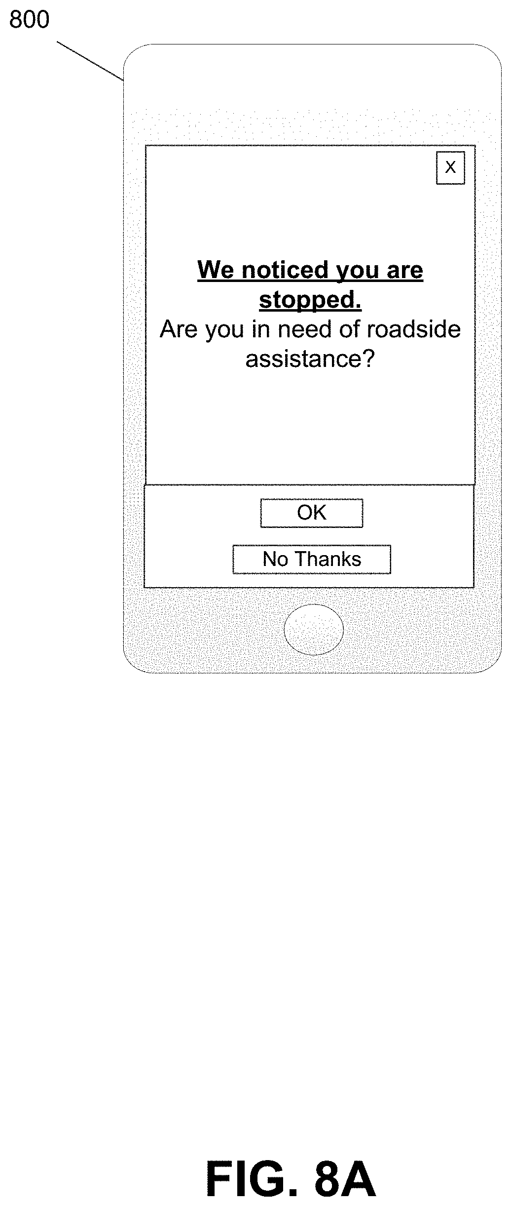
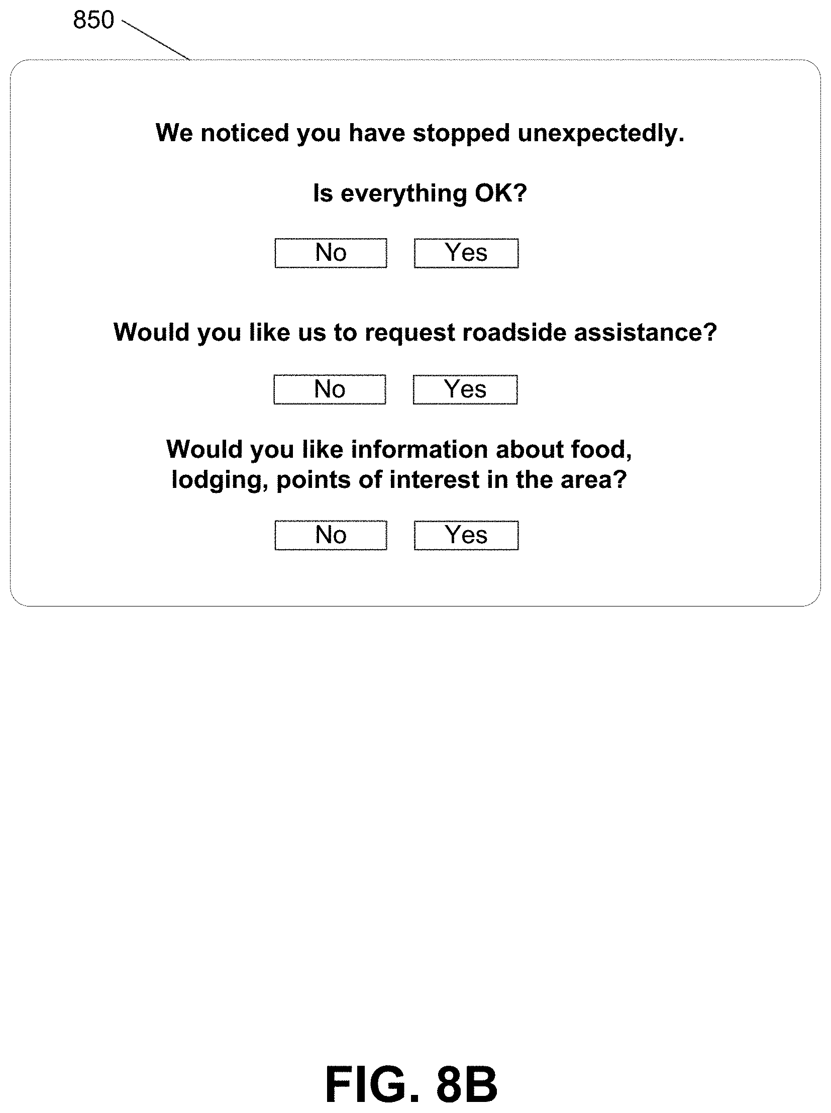
FIGS. 8A-B illustrate example user interfaces for providing notifications in accordance with embodiments of the invention.
DETAILED DESCRIPTION
In the following description of the various embodiments, reference is made to the accompanying drawings, which form a part hereof, and in which is shown by way of illustration, various embodiments of the disclosure that may be practiced. It is to be understood that other embodiments may be utilized.
As will be appreciated by one of skill in the art upon reading the following disclosure, various aspects described herein may be embodied as a method, a computer system, or a computer program product. Accordingly, those aspects may take the form of an entirely hardware embodiment, an entirely software embodiment, or an embodiment combining software and hardware aspects. Furthermore, such aspects may take the form of a computer program product stored by one or more computer-readable storage media having computer-readable program code, or instructions, embodied in or on the storage media. Any suitable computer-readable storage media may be utilized, including hard disks, CD-ROMs, optical storage devices, magnetic storage devices, and/or any combination thereof. In addition, various signals representing data or events as described herein may be transferred between a source and a destination in the form of electromagnetic waves traveling through signal-conducting media such as metal wires, optical fibers, and/or wireless transmission media (e.g., air and/or space).
As will be discussed more fully herein, arrangements described herein are directed to determining a location of a vehicle, determining a reason the vehicle is stopped, and generating and transmitting one or more different types of notifications. Conventional roadside assistance systems often require a user to provide information about an issue that has occurred, request assistance, or the like. If stopped in an emergency situation on a highway, this can be difficult for a user and sometimes dangerous. Accordingly, it is advantageous to detect issues that have caused a vehicle to stop along a highway and automatically provide assistance if the reason for stopping is urgent or provide an offer of assistance or additional information if the reason for stopping is not urgent. Additionally, conventional roadside assistance systems typically utilize specialized hardware installed in the vehicle. The use of specialized hardware limits the number of vehicles that can be utilized and requires drivers to invest in expensive hardware in order to obtain roadside assistance.
Systems and methods in accordance with embodiments of the invention can proactively determine if an individual is likely in need of roadside assistance. Roadside assistance can be provided for any kind of road, such as local routes, state routes, rural routes, etc. Information can be collected from the individual's mobile device, including the person's location, the type of road, and/or ambient noise. One aspect to be considered during the detection roadside assistance can include observing a user's physical activities/movements during the incident. These physical activities can include, but are not limited to, determining if the user stepped out of vehicle, the location of the user relative to the vehicle, and determining the status of the vehicle (tire pressure, trunk open, hood open, etc.). In many embodiments, machine learning algorithms can be utilized to determine a likelihood that a user is engaged in one or more activities activity by analyzing one or more sensors (gyroscope, accelerometer, GPS, etc.) in the user's mobile device.
By utilizing the individual's mobile device, roadside assistance can be provided to any vehicle without the need for dedicated systems to be installed in the vehicle. If it is determined that the individual likely needs roadside assistance, the system can proactively contact the individual to see if roadside assistance is desired, and if so, initiates roadside assistance. The system also can provide helpful information, such as safety information, and/or automatically contact other individuals to alert them of the roadside event and the location of the individual. These and various other arrangements will be described more fully herein.
Roadside Assistance Systems
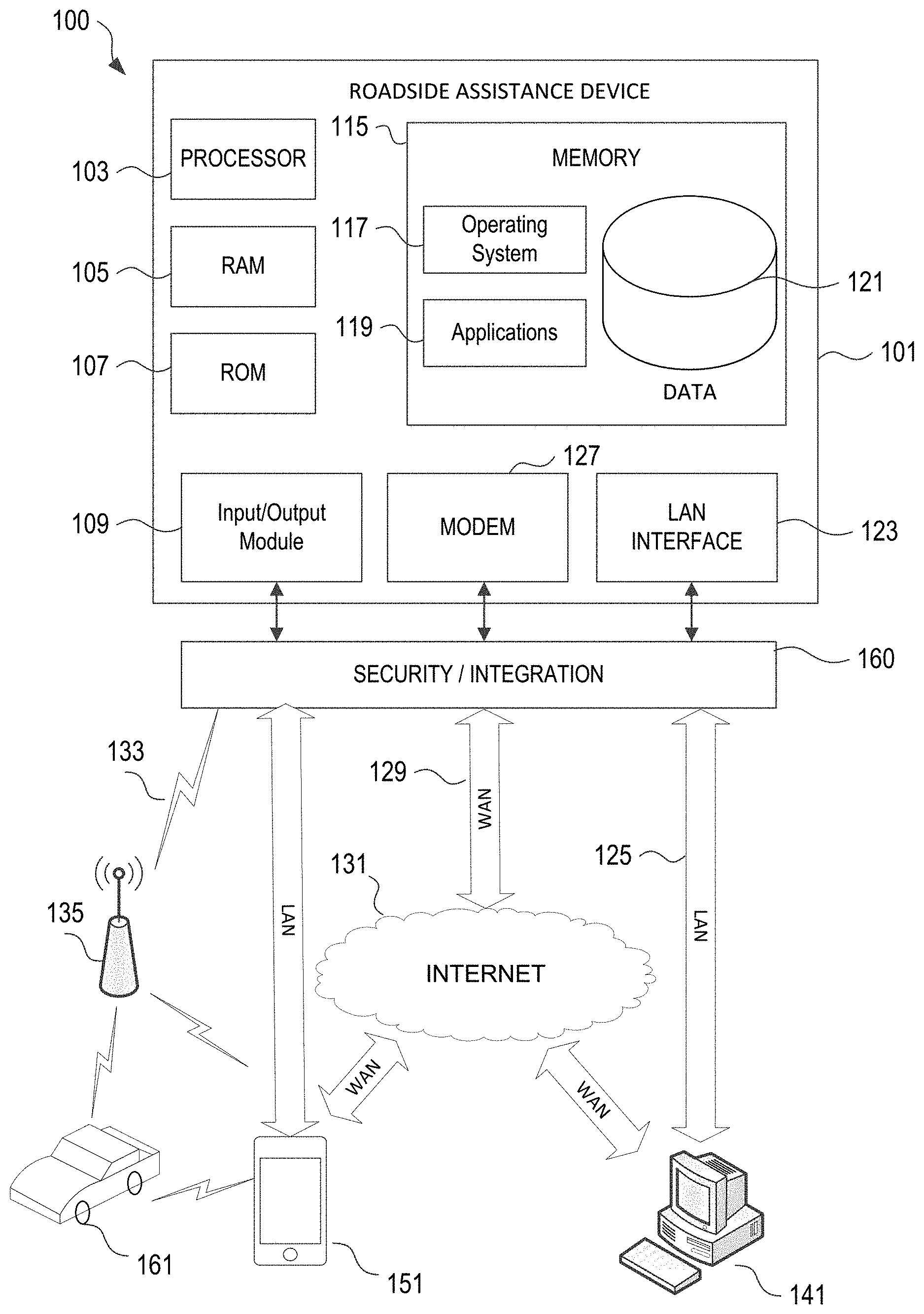
FIG. 1 illustrates a block diagram a roadside assistance device 101 in a roadside assistance system 100 in accordance with an embodiment of the invention. The roadside assistance device 101 may have a processor 103 for controlling overall operation of the device 101 and its associated components, including RAM 105, ROM 107, input/output module 109, and memory 115. The roadside assistance device 101, along with one or more additional devices (e.g., terminal 141, mobile device 151, and/or security and integration hardware 160) may correspond to any of multiple systems or devices described herein, such as personal mobile devices, vehicle-based computing devices, insurance systems servers, roadside assistance provider servers, roadside assistance servers, internal data sources, external data sources and other various devices in a roadside assistance system. These various computing systems may be configured individually or in combination, as described herein, for receiving signals and/or transmissions from one or more computing devices, the signals or transmissions including data related to location of a vehicle, operating parameters of a vehicle, and the like, processing the signals or transmissions to determine a location of the vehicle, operating parameters of the vehicle, a cause of an issue associated with the vehicle, and the like, using the devices of the roadside assistance systems described herein. In addition to the features described above, the techniques described herein also may be used for generating and displaying one or more different types of notifications, transmitting a request for assistance to a service center computing device, and the like.
Input/output (I/O) 109 may include a microphone, keypad, touch screen, and/or stylus through which a user of the roadside assistance device 101 may provide input, and may also include one or more of a speaker for providing audio output and a video display device for providing textual, audiovisual, and/or graphical output. Software may be stored within memory 115 and/or storage to provide instructions to processor 103 allowing roadside assistance device 101 to perform various actions. For example, memory 115 may store software used by the device 101, such as an operating system 117, application programs 119, and/or an associated internal database 121. The various hardware memory units in memory 115 may include volatile and nonvolatile, removable and non-removable media implemented in any method or technology for storage of information such as computer-readable instructions, data structures, program modules or other data. Certain devices and systems within roadside assistance systems may have minimum hardware requirements in order to support sufficient storage capacity, processing capacity, analysis capacity, network communication, etc. Memory 115 also may include one or more physical persistent memory devices and/or one or more non-persistent memory devices. Memory 115 may include, but is not limited to, random access memory (RAM) 105, read only memory (ROM) 107, electronically erasable programmable read only memory (EEPROM), flash memory or other memory technology, CD-ROM, digital versatile disks (DVD) or other optical disk storage, magnetic cassettes, magnetic tape, magnetic disk storage or other magnetic storage devices, or any other medium that can be used to store the desired information and that can be accessed by processor 103.
Processor 103 may include a single central processing unit (CPU), which may be a single-core or multi-core processor (e.g., dual-core, quad-core, etc.), or may include multiple CPUs. Processor(s) 103 and its associated components may allow the roadside assistance device 101 to execute a series of computer-readable instructions, for example, receive signals or transmissions including location information, vehicle operation information, scan for diagnostic codes, and the like, to determine a location of the vehicle, determine a cause of an issue associated with the vehicle, control amount and type of data received, and the like.
The mobile device 151 (e.g., a personal mobile device, vehicle-based system, insurance system server, roadside assistance server, etc.) may operate in a networked environment 100 supporting connections to one or more remote computers, such as terminals 141, 151, and 161. Such terminals may be personal computers or servers 141 (e.g., home computers, laptops, web servers, database servers), mobile communication devices 151 (e.g., mobile phones, tablet computers, etc.), vehicle-based computing systems 161 (e.g., on-board vehicle systems, telematics devices, mobile phones or other personal mobile devices within vehicles), and the like, each of which may include some or all of the elements described above with respect to the roadside assistance device 101. The network connections depicted in FIG. 1 include a local area network (LAN) 125, a wide area network (WAN) 129, and a wireless telecommunications network 133, but may also include fewer or additional networks. When used in a LAN networking environment, the roadside assistance device 101 may be connected to the LAN 125 through a network interface or adapter 123. When used in a WAN networking environment, the roadside assistance device 101 may include a modem 127 or other means for establishing communications over the WAN 129, such as network 131 (e.g., the Internet). When used in a wireless telecommunications network 133, the roadside assistance device 101 may include one or more transceivers, digital signal processors, and additional circuitry and software for communicating with wireless computing devices 151 and 161 (e.g., mobile phones, portable customer computing devices, vehicle-based computing devices and systems, etc.) via one or more network devices 135 (e.g., base transceiver stations) in the wireless network 133. It should be noted that, in a variety of embodiments, the roadside assistance device 101 is implemented using mobile device 151. In many embodiments, the roadside assistance device 101 communicates with mobile device 151 to cooperatively implement and perform the systems and methods described herein.
Also illustrated in FIG. 1 is a security and integration layer 160, through which communications are sent and managed between the roadside assistance device 101 (e.g., a personal mobile device, a vehicle-based computing device, a roadside assistance server or computing platform, an intermediary server and/or external data source servers, etc.) and the remote devices (141, 151, and 161) and remote networks (125, 129, and 133). The security and integration layer 160 may include one or more separate computing devices, such as web servers, authentication servers, and/or various networking components (e.g., firewalls, routers, gateways, load balancers, etc.), having some or all of the elements described above with respect to the roadside assistance device 101. As an example, a security and integration layer 160 of a roadside assistance device 101 may include a set of web application servers configured to use secure protocols and to insulate the roadside assistance device 101 from external devices 141, 151, and 161. In some cases, the security and integration layer 160 may correspond to a set of dedicated hardware and/or software operating at the same physical location and under the control of same entities as roadside assistance device 101. For example, security and integration layer 160 may correspond to one or more dedicated web servers and network hardware in a vehicle and driver information datacenter or in a cloud infrastructure supporting cloud-based vehicle identification, location identification, vehicle operational parameters identification, issue detection, and the like. In other examples, the security and integration layer 160 may correspond to separate hardware and software components which may be operated at a separate physical location and/or by a separate entity.
As discussed herein, the data transferred to and from various devices in a roadside assistance system 100 may include secure and sensitive data, such as confidential vehicle operation data, insurance policy data, and confidential user data from drivers and passengers in vehicles. Therefore, it may be desirable to protect transmissions of such data using secure network protocols and encryption, and also to protect the integrity of the data when stored on the various devices within a system, such as mobile devices, vehicle-based devices, insurance servers, roadside assistance servers, external data source servers, or other computing devices in the roadside assistance system 100, using the security and integration layer 160 to authenticate users and restrict access to unknown or unauthorized users. In various implementations, security and integration layer 160 may provide, for example, a file-based integration scheme or a service-based integration scheme for transmitting data between the various devices in roadside assistance system 100. Data may be transmitted through the security and integration layer 160, using various network communication protocols. Secure data transmission protocols and/or encryption may be used in file transfers to protect the integrity of the data, for example, File Transfer Protocol (FTP), Secure File Transfer Protocol (SFTP), and/or Pretty Good Privacy (PGP) encryption. In other examples, one or more web services may be implemented within the various roadside assistance devices 101 in the roadside assistance system 100 and/or the security and integration layer 160. Web services may be accessed by authorized external devices and users to support input, extraction, and manipulation of the data (e.g., vehicle data, driver data, location data, breakdown issue data, etc.) between the various devices in the roadside assistance system 100. Web services built to support a personalized display system may be cross-domain and/or cross-platform, and may be built for enterprise use. Such web services may be developed in accordance with various web service standards, such as the Web Service Interoperability (WS-I) guidelines. In some examples, a driver data, vehicle data, location data, breakdown issue data and/or breakdown data analysis web service, or the like, may be implemented in the security and integration layer 160 using the Secure Sockets Layer (SSL) or Transport Layer Security (TLS) protocol to provide secure connections between roadside assistance devices 101 and various clients 141, 151, and 161. SSL or TLS may use HTTP or HTTPS to provide authentication and confidentiality. In other examples, such web services may be implemented using the WS-Security standard, which provides for secure SOAP messages using XML encryption. In still other examples, the security and integration layer 160 may include specialized hardware for providing secure web services. For example, secure network appliances in the security and integration layer 160 may include built-in features such as hardware-accelerated SSL and HTTPS, WS-Security, and firewalls. Such specialized hardware may be installed and configured in the security and integration layer 160 in front of the web servers, so that any external devices may communicate directly with the specialized hardware.
Although not shown in FIG. 1, various elements within memory 115 or other components in system 100, may include one or more caches, for example, CPU caches used by the processing unit 103, page caches used by the operating system 117, disk caches of a hard drive, and/or database caches used to cache content from database 121. For embodiments including a CPU cache, the CPU cache may be used by one or more processors in the processing unit 103 to reduce memory latency and access time. In such examples, a processor 103 may retrieve data from or write data to the CPU cache rather than reading/writing to memory 115, which may improve the speed of these operations. In some examples, a database cache may be created in which certain data from a database 121 (e.g., a database of driver data, database of vehicle information, database of location information, database of breakdown issue information, etc.) is cached in a separate smaller database on an application server separate from the database server (e.g., at a personal mobile device, vehicle-based data, or intermediary network device or cache device, etc.). For instance, in a multi-tiered application, a database cache on an application server can reduce data retrieval and data manipulation time by not needing to communicate over a network with a back-end database server. These types of caches and others may be included in various embodiments, and may provide potential advantages in certain implementations of roadside assistance systems, such as faster response times and less dependence on network conditions when transmitting and receiving driver information, vehicle information, location information, roadside assistance issue information, and the like.
It will be appreciated that the network connections shown are illustrative and other means of establishing a communications link between the computers may be used. The existence of any of various network protocols such as TCP/IP, Ethernet, FTP, HTTP and the like, and of various wireless communication technologies such as GSM, CDMA, WiFi, and WiMAX, is presumed, and the various computing devices in roadside assistance system components described herein may be configured to communicate using any of these network protocols or technologies.
Additionally, one or more application programs 119 may be used by the various roadside assistance devices 101 within the roadside assistance system 100 (e.g., vehicle data, driver data, location data, roadside assistance issue data, and/or roadside assistance applications, etc.), including computer executable instructions for receiving and analyzing various signals or transmissions including location information, vehicle operating data, other vehicle operating data, and the like, determining a location of a vehicle, determining a cause of an issue, controlling an amount or type of data transmitted or received and the like.
FIG. 2 depicts an environment 200 including an illustrative roadside assistance computing platform 210 for determining a location of a vehicle, determining that the vehicle is stopped, identifying an issue causing the vehicle to stop, and generating and transmitting one or more notifications based on the determined issue, according to one or more aspects described herein. For instance, the environment 200 includes a roadside assistance computing platform 210, which may include one or more processors 211, memory 212, and communication interface 220. A data bus may interconnect processor(s) 211, memory 212, and communication interface 220. Communication interface 220 may be a network interface configured to support communication between roadside assistance computing platform 210 and one or more networks (e.g., network 230). One or more computing destinations 202, 204, 206 may be in communication with the roadside assistance computing platform 210 (e.g., via network 230). Memory 212 may include one or more program modules having instructions that when executed by processor(s) 211 cause roadside assistance computing platform 210 to perform one or more functions described herein and/or one or more databases that may store and/or otherwise maintain information which may be used by such program modules and/or processor(s) 211. In some instances, the one or more program modules and/or databases may be stored by and/or maintained in different memory units of roadside assistance computing platform 210 and/or by different computer systems that may form and/or otherwise make up the roadside assistance computing platform 210. In some arrangements, different features or processes performed may be performed by different sets of instructions, such that the processor may execute each desired set of instructions to perform different functions described herein.
For example, memory 212 may include a location analysis module 213. The location analysis module 213 may receive data (e.g., signals or other electronic transmissions), for example, in real-time, including location information of a vehicle. In some examples, the location data may be received from a mobile device 202, which may include, for example, a smartphone, cell phone, tablet computing device, or the like, associated with the user and currently located with or within the vehicle. Global positioning system (GPS) data may be received from the mobile device 202 and processed to determine a current location of the vehicle, which may aid in determining whether the vehicle is currently located on a highway. In another example, GPS data may be received from one or more sensors located within the vehicle and transmitted via an on-board vehicle computing device 206. The data received may be processed to determine the current location of the vehicle.
Memory 212 may further include a data control module 214. Data control module 214 may be configured to control an amount or type of data collected by one or more sensors, transmitted to roadside assistance computing platform 210, or the like. For example, based on location analysis, vehicle operation data, and the like, the data control module 214 may increase or decrease (e.g., limit) an amount or type of data collected by one or more sensors (e.g., vehicle sensors, user computing device sensors, or the like). In some examples, the data control module 214 may determine an amount or type of data to be collected by the sensors or transmitted to the roadside assistance computing platform 210 and may transmit a command or instruction to a computing device associated with the sensors, such as on-board vehicle computing device 206, user computing device 202, or the like, controlling the amount or type of data collected. Accordingly, if a vehicle is determined to not be traveling on a highway, the data control module 214 may limit the amount of data transmitted to the roadside assistance computing platform 210 for processing to improve efficiency, conserve computing resources, and the like. Alternatively, if a vehicle is determined to be traveling on a highway, the data control module 214 may increase an amount or type of data collected by sensors and/or transmitted to the roadside assistance computing platform 210 to evaluate operational parameters of the vehicle, determine whether the vehicle is stopped, determine a cause or type of issue causing the vehicle to stop, and the like.
Memory 212 may further include an operational analysis data module 215. Operational analysis data module 215 may be configured to receive data (e.g., signals or other electronic transmissions), for example, in real-time, associated with operating parameters of the vehicle. For instance, data such as current speed, recent historical speeds, and the like, may be received by the operational analysis data module 215 and processed to evaluate operational parameters of the vehicle (e.g., to determine whether the vehicle is stopped). In some examples, data may be received from sensors in a user computing device 202. Data may be received from one or more vehicle based sensors and transmitted via an on-board vehicle computing device 206, telematics device, mobile device 202, or the like.
Memory 212 may further include vehicle-to-vehicle or vehicle-to-infrastructure data analysis module 216. The vehicle-to-vehicle or vehicle-to-infrastructure data analysis module 216 may be configured to receive data via short range vehicle-to-vehicle and/or vehicle-to-infrastructure communications to evaluate operating parameters of other vehicle at or near a location of the vehicle. For instance, the vehicle-to-vehicle or vehicle-to-infrastructure data analysis module 216 may receive data from one or more other vehicles, infrastructure, or the like, at or near a location of the vehicle being evaluated to determine whether the other vehicles are, for example, also stopped or are still moving and, if so, at what speed. This may aid in determining whether the vehicle being evaluated is stopped due to heavy traffic as opposed to being stopped because of an emergency, breakdown, or the like.
Memory 212 may further include issue identification module 217. Issue identification module 217 may be configured to receive data (e.g., signals or other electronic transmissions) to determine whether an issue with a vehicle has occurred and, if so, to determine whether the cause of the issue is an urgent situation reason or a non-urgent situation reason. For example, the issue identification module 217 may receive data indicating that a vehicle is stopped on a highway, that other traffic around the vehicle is still moving, and that the vehicle has not exited the highway. Accordingly, the issue identification module 217 may scan (e.g., in real-time) the diagnostic codes of the vehicle to determine whether one or more diagnostic codes have been activated. If so, the issue identification module 217 may determine that the vehicle is stopped for an urgent situation reason (e.g., low tire pressure, low fuel, low battery power, low oil level, or the like). If no diagnostic codes have been activated, in some examples, the issue identification module 217 may determine that the vehicle is stopped for a non-urgent situation reason (e.g., to place a phone call, to address an issue within the vehicle, or the like). In many embodiments, a mobile device includes one or more sensors capable of determining diagnostic codes for the vehicle (and/or any of the information described by the diagnostic codes) without a connection to the on-board vehicle diagnostic system. In this way, it should be understood that any vehicle data described herein can be captured and/or generated using a mobile device.
Memory 212 may further include a notification generation module 218. Notification generation module 218 may be configured to generate, transmit and/or cause to display one or more different types of notifications based on whether the vehicle is stopped for an urgent situation reason or a non-urgent situation reason. For instance, if the vehicle is stopped for an urgent situation reason (e.g., as determined by the issue identification module 217), a request for assistance may be transmitted to a service center computing device 204 and a notification may be generated and transmitted to the user computing device 202, on-board vehicle computing device 206, or the like, indicating that an issue has been detected and that a request for assistance has been sent. In some examples, the notification may include an estimated time of arrival of assistance. Accordingly, in at least some examples, if it is determined that the vehicle is stopped for an urgent situation reason, the roadside assistance computing platform 210 may automatically request roadside assistance for the vehicle (e.g., without additional user input). If it is determined (e.g., by the issue determination module 217) that the vehicle is stopped for a non-urgent situation reason, a second type of notification may be generated and transmitted to a device. The second type of notification may be different from the first type of notification. For instance, the second type of notification may indicate that the system has recognized that the vehicle is stopped, may request user input confirming that there is no emergency or urgent situation, may provide information about a surrounding area, and the like. The generated notifications may be transmitted to one or more computing devices, e.g., devices 202, 204, 206, via push notifications, short message service (SMS), via an application executing one or more devices 202, 204, 206, or the like. The roadside assistance computing platform 210 may cause the notifications to display on a display of the one or more computing devices 202, 204, 206.
Roadside assistance computing platform 210 may further include a database 219. The database 219 may include or store information associated with the driver of the vehicle, the vehicle itself, insurance policy information, historical issues detected, and the like. This information may be used to aid in determining when an issue has occurred, what type of issue, and the like. For instance, historical data may indicate that that the vehicle has previously stopped in a same or similar location. Accordingly, this may indicate that the vehicle is stopped for a non-urgent situation reason.
Although the various modules of the roadside assistance computing platform 210 are described separately, functionality of the various modules may be combined and/or may be performed by a single device or multiple computing devices in communication without departing from the invention. In particular, it should be noted that the roadside assistance computing platform may be implemented in whole or in part by mobile device 202.
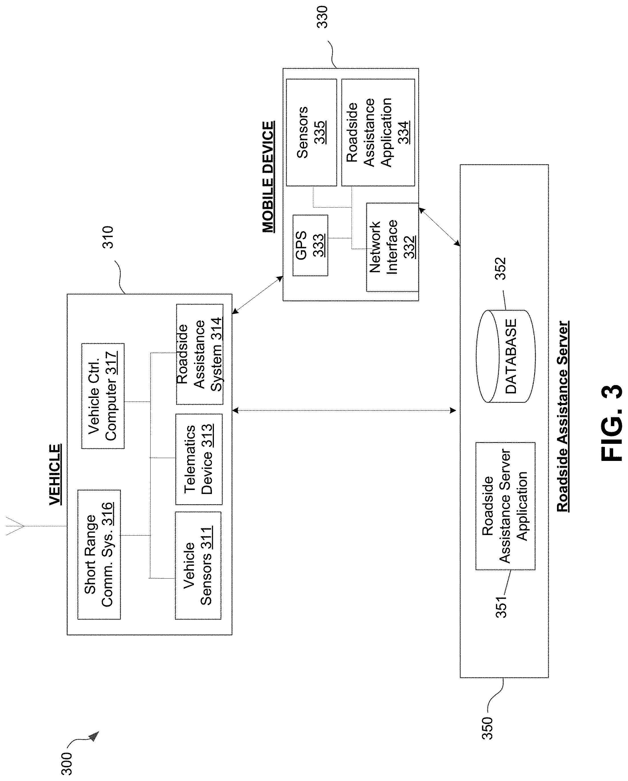
FIG. 3 is a diagram of an illustrative roadside assistance system 300. The roadside assistance system 300 includes a vehicle 310 (e.g., the vehicle being evaluated for potential breakdown), a mobile device 330, a roadside assistance server 350, and additional related components. As discussed herein, the components of the system 300, individually or using communication and collaborative interaction, may determine a location of vehicle 310, determine whether the vehicle has stopped, control an amount or type of data received and/or processed, determine whether the vehicle is stopped for an urgent situation reason or a non-urgent situation reason, and generate and transmit one or more notifications. To perform such functions, the components shown in FIG. 3 each may be implemented in hardware, software, or a combination of the two. Additionally, each component of the roadside assistance system 300 may include a computing device (or system) having some or all of the structural components described herein for mobile device 330.
Vehicle 310 in the roadside assistance system 300 may be, for example, an automobile, a motorcycle, a scooter, a bus, a recreational vehicle, a boat, or other vehicle for which vehicle data, location data, driver data (or operator data), operational data and/or other driving data (e.g., location data, time data, weather data, etc.) may be collected and/or analyzed. The vehicle 310 includes vehicle operation sensor 311 capable of detecting and recording various conditions at the vehicle and operational parameters of the vehicle. For example, sensor 311 may detect and store data corresponding to the vehicle's location (e.g., GPS coordinates), time, travel time, speed and direction, rates of acceleration or braking, gas mileage, and specific instances of sudden acceleration, braking, swerving, and distance traveled. Sensor 311 also may detect and store data received from the vehicle's 310 internal systems, such as impact to the body of the vehicle, air bag deployment, tire status, headlights usage, brake light operation, door opening and closing, door locking and unlocking, cruise control usage, hazard lights usage, windshield wiper usage, horn usage, turn signal usage, seat belt usage, phone and radio usage within the vehicle, autonomous driving system usage, maintenance performed on the vehicle, and other data collected by the vehicle's computer systems, including the vehicle on-board diagnostic systems (OBD).
Additional sensors 311 may detect and store the external driving conditions, for example, external temperature, rain, snow, light levels, and sun position for driver visibility. For example, external cameras and proximity sensors 311 may detect other nearby vehicles, vehicle spacing, traffic levels, road conditions, traffic obstructions, animals, cyclists, pedestrians, and other conditions that may factor into a roadside assistance analysis. Sensor 311 also may detect and store data relating to moving violations and the observance of traffic signals and signs by the vehicle 310. Additional sensors 311 may detect and store data relating to the maintenance of the vehicle 310, such as the engine status, oil level, engine coolant temperature, odometer reading, the level of fuel in the fuel tank, engine revolutions per minute, software upgrades, and/or tire pressure.
Vehicles sensor 311 also may include cameras and/or proximity sensors capable of recording additional conditions inside or outside of the vehicle 310. For example, internal cameras may detect conditions such as the number of the passengers and the types of passengers (e.g. adults, children, teenagers, pets, etc.) in the vehicles, and potential sources of driver distraction within the vehicle (e.g., pets, phone usage, and unsecured objects in the vehicle). Sensor 311 also may be configured to collect data identifying a current driver from among a number of different possible drivers, for example, based on driver's seat and mirror positioning, driving times and routes, radio usage, etc. Voice/sound data along with directional data also may be used to determine a seating position within a vehicle 310. Sensor 311 also may be configured to collect data relating to a driver's movements or the condition of a driver. For example, vehicle 310 may include sensors that monitor a driver's movements, such as the driver's eye position and/or head position, etc. Additional sensors 311 may collect data regarding the physical or mental state of the driver, such as fatigue or intoxication. The condition of the driver may be determined through the movements of the driver or through other sensors, for example, sensors that detect the content of alcohol in the air or blood alcohol content of the driver, such as a breathalyzer, along with other biometric sensors.
Certain vehicle sensors 311 also may collect information regarding the driver's route choice, whether the driver follows a given route, and to classify the type of trip (e.g. commute, errand, new route, etc.) and type of driving (e.g., continuous driving, parking, stop-and-go traffic, etc.). In certain embodiments, sensors and/or cameras 311 may determine when and how often the vehicle 310 stays in a single lane or strays into other lane. A Global Positioning System (GPS), locational sensors positioned inside the vehicle 310, and/or locational sensors or devices external to the vehicle 310 may be used to determine the route, speed, lane position, road-type (e.g. highway, entrance/exit ramp, residential area, etc.) and other vehicle position/location data.
The data collected by vehicle sensor 311 may be stored and/or analyzed within the vehicle 310, such as for example by a roadside assistance system 314 integrated into the vehicle, and/or may be transmitted to one or more external devices. For example, as shown in FIG. 3, sensor data may be transmitted via a telematics device 313 to one or more remote computing devices, such as personal mobile device 330, roadside assistance server 350, and/or other remote devices.
As shown in FIG. 3, the data collected by vehicle sensor 311 may be transmitted to roadside assistance server 350, mobile device 330, and/or additional external servers and devices via telematics device 313. As discussed herein, the telematics device 313 may receive vehicle operation data and driving data from vehicle sensor 311, and may transmit the data to one or more external computer systems (e.g., roadside assistance server 350 of an insurance provider, financial institution, or other entity) over a wireless transmission network. Telematics device 313 also may be configured to detect or determine additional types of data relating to real-time driving and the condition of the vehicle 310. The telematics device 313 also may store the type of vehicle 310, for example, the make, model, trim (or sub-model), year, and/or engine specifications, as well as other information such as vehicle owner or driver information, insurance information, and financing information for the vehicle 310. In the example shown in FIG. 3, telematics device 313 may receive vehicle driving data from vehicle sensor 311, and may transmit the data to a roadside assistance server 350. However, in other examples, one or more of the vehicle sensors 311 or systems may be configured to receive and transmit data directly from or to a roadside assistance server 350 without using a telematics device. For instance, telematics device 313 may be configured to receive and transmit data from certain vehicle sensors 311 or systems, while other sensors or systems may be configured to directly receive and/or transmit data to a roadside assistance server 350 without using the telematics device 313. Thus, telematics device 313 may be optional in certain embodiments. In a variety of embodiments, a mobile device is capable of capturing and/or generating any of the data obtained by a telematics device without a connection to the telematics device.
In some examples, telematics, sensor data, and/or other data (e.g., error or issue codes associated with maintenance of a vehicle) may be transmitted (e.g., to roadside assistance server) and may be used to further aid in identifying an issue or type of issue a vehicle may be having.
Vehicle 310 may further include a short-range communication system 316. The short-range communication systems 316 may be vehicle-based data transmission systems configured to transmit vehicle operational data to other nearby vehicles, and to receive vehicle operational data from other nearby vehicles. In some examples, communication system 316 may use the dedicated short-range communications (DSRC) protocols and standards to perform wireless communications between vehicles. In the United States, 75 MHz in the 5.850-5.925 GHz band have been allocated for DSRC systems and applications, and various other DSRC allocations have been defined in other countries and jurisdictions. However, short-range communication system 316 need not use DSRC, and may be implemented using other short-range wireless protocols in other examples, such as WLAN communication protocols (e.g., IEEE 802.11), Bluetooth (e.g., IEEE 802.15.1), or one or more of the Communication Access for Land Mobiles (CALM) wireless communication protocols and air interfaces. The vehicle-to-vehicle (V2V) transmissions between the short-range communication system 316 may be sent via DSRC, Bluetooth, satellite, GSM infrared, IEEE 802.11, WiMAX, RFID, and/or any suitable wireless communication media, standards, and protocols. In certain systems, short-range communication system 316 may include specialized hardware installed in vehicles 310 (e.g., transceivers, antennas, etc.), while in other examples the communication system 316 may be implemented using existing vehicle hardware components (e.g., radio and satellite equipment, navigation computers) or may be implemented by software running on the mobile device 330 of drivers and passengers within the vehicle 310. The range of V2V communications may depend on the wireless communication standards and protocols used, the transmission/reception hardware (e.g., transceivers, power sources, antennas), and other factors. Short-range V2V communications may range from just a few feet to many miles, and different types of driving behaviors, vehicle operational parameters, and the like, may be determined depending on the range of the V2V communications.
V2V communications also may include vehicle-to-infrastructure (V2I) communications, such as transmissions to or from vehicles to or from non-vehicle receiving devices, such as infrastructure. Infrastructure may include one or more of toll booths, rail road crossings, parking garages, road segments, parking lots, buildings or other structures, and/or road-side traffic monitoring devices which may include one or more sensors for detecting environmental conditions (e.g., weather, lighting, etc.) as well as parking availability. Certain V2V communication systems may periodically broadcast data from a vehicle 310 to any other vehicle or other infrastructure device capable of receiving the communication within the range of the vehicle's transmission capabilities. For example, a vehicle 310 may periodically broadcast (e.g., every 0.1 second, every 0.5 seconds, every second, every 5 seconds, dynamically, etc.) certain vehicle operation data via its short-range communication system 316, regardless of whether or not any other vehicles or reception devices are in range. In other examples, a vehicle communication system 316 may first detect nearby vehicles and receiving devices, and may initialize communication with each by performing a handshaking transaction before beginning to transmit its vehicle operation data to the other vehicles and/or devices. Broadcasts from infrastructure may also have varying ranges and, in some examples, infrastructure may broadcast to an intermediate station which may then relay the information to the roadside assistance server 350 (or other device).
The types of vehicle operational data, vehicle driving data, breakdown issue data, or the like, transmitted to or from vehicle 310 and/or infrastructure may depend on the protocols and standards used for the V2V or V2I communication, the range of communications, and other factors. In certain examples, vehicle 310 may periodically broadcast corresponding sets of similar vehicle driving data, such as the location (which may include an absolute location in GPS coordinates or other coordinate systems, and/or a relative location with respect to another vehicle or a fixed point), speed, and direction of travel. In certain examples, the nodes in a V2V (or V2I) communication system (e.g., vehicles and other reception devices) may use internal clocks with synchronized time signals and may send transmission times within V2V (or V2I) communications so that the receiver may calculate its distance from the transmitting node based on the difference between the transmission time and the reception time. The state or usage of the vehicle's controls and instruments may also be transmitted, for example, whether the vehicle is accelerating, braking, turning, and by how much, and/or which of the vehicle's instruments are currently activated by the driver (e.g., head lights, turn signals, hazard lights, cruise control, 4-wheel drive, traction control, etc.). Vehicle warnings such as a detection by the vehicle's internal systems that the vehicle is skidding, that an impact has occurred, or that the vehicle's airbags have been deployed, that a vehicle has stopped unexpectedly, also may be transmitted in V2V (or V2I) communications.
In various other examples, any data collected by any vehicle sensors 311 potentially may be transmitted via V2V or V2I communication to other nearby vehicles or infrastructure devices receiving V2V or V2I communications from communication system 316. Further, additional vehicle driving data not from the vehicle's sensors (e.g., vehicle make/model/year information, driver insurance information, driving route information, vehicle maintenance information, driver scores, etc.) may be collected from other data sources, such as mobile device 330, and transmitted using V2V or V2I communications to nearby vehicles and other receiving devices using communication system 316.
The system 300 in FIG. 3 also includes a mobile device 330. Mobile device 330 may be, for example, a smartphone or other mobile phone, personal digital assistant (PDAs), tablet computer, and the like, and may include some or all of the elements described herein. Specifically, it should be noted that some or all of the functionality described with respect to vehicle 310 and/or roadside assistance server 350 can be implemented using mobile device 330. Some mobile devices in systems 300 (e.g., mobile device 330) may be configured to establish communication sessions with vehicle-based devices and various internal components of vehicle 310 via wireless networks or wired connections (e.g., for docked devices), whereby such mobile devices 330 may have secure access to internal vehicle sensors 311 and other vehicle-based systems. However, in other examples, the mobile device 330 might not connect to vehicle-based computing devices and internal components, but may operate independently by communicating with vehicle 310 via their standard communication interfaces (e.g., telematics device 313, etc.), or might not connect at all to vehicle 310.
Mobile device 330 may include a network interface 332, which may include various network interface hardware (e.g., adapters, modems, wireless transceivers, etc.) and software components to enable mobile device 330 to communicate with roadside assistance server 350, vehicle 310, and various other external computing devices. One or more specialized software applications, such as a roadside assistance application 334, may be stored in the memory of the mobile device 330. The roadside assistance application 334 may be received (e.g., downloaded or otherwise provided) via network interface 332 from the roadside assistance server 350, vehicle 310, or other application providers (e.g., application stores). As discussed below, the roadside assistance application 334 may or may not include various user interface screens, and may be configured to run as user-initiated applications or as background applications. The memory of the mobile device 330 also may include databases configured to receive and store vehicle data, driving data, driving trip data, and the like, associated with one or more drivers, vehicles, and the like.
Mobile device 330 may include various components configured to generate and/or receive vehicle data, driver data, and driving data or other operational data, as well as communicate with other devices within the system 300. As discussed herein, the roadside assistance software application 334 may store and analyze the data from various mobile device components, historical data, and the like, and may use this data, in conjunction with one or more other devices (e.g., roadside assistance server 350), to identify a location of a vehicle, determine operational parameters of a vehicle, identify a potential issue or type of issue, generate, transmit or receive notifications, and the like. Mobile computing device 330 may store, analyze, and/or transmit the data to one or more other devices. For example, mobile computing device 330 may transmit data directly to one or more roadside assistance servers 350. As discussed above, the roadside assistance server 350 may determine a location of the vehicle being evaluated, control data collected or received and processed by the system, determine operational parameters of the vehicle, identify one or more issues or types of issues, and generate and transmit notifications. In some examples, one or more of these functions may be performed by the processing components of the mobile device (e.g., via roadside assistance application 334). Therefore, in certain arrangements, mobile computing device 330 may be used in conjunction with, or in place of, the roadside assistance server 350.
Vehicle 310 may include roadside assistance system 314, which may be a separate computing device or may be integrated into one or more other components within the vehicle 310, such as the telematics device 313, autonomous driving systems, or the internal computing systems of vehicle 310. As discussed above, roadside assistance analysis computer 314 also may be implemented by computing devices independent from the vehicle 310, such as mobile device 330 of the drivers or passengers, or one or more separate computer systems (e.g., a user's home or office computer). In any of these examples, the roadside assistance system 314 may contain some or all of the hardware/software components of various devices and systems described herein. Further, in certain implementations, the functionality of the roadside assistance system, such as storing and analyzing driver data, vehicle data, location data, and the like, may be performed in a roadside assistance server 350 rather than by the individual vehicle 310 or mobile device 330. In such implementations, the vehicle 310 and and/or mobile device 330, might only collect and transmit driver data, sensor data, location data, vehicle operational data, and the like to roadside assistance server 350, and thus the vehicle-based roadside assistance system 314 may be optional.
The system 300 also may include one or more roadside assistance servers 350, containing some or all of the hardware/software components described herein. The roadside assistance server 350 may include hardware, software, and network components to receive data (e.g., signals or other electronic transmissions) related to location, operational data, and the like, process the data, control an amount or type of data collected by sensors and/or transmitted for processing or analysis, identify an issue or type of issue associated with a vehicle, generate and transmit notifications, and the like, from one or more of vehicle 310, mobile device 330, and other data sources. The roadside assistance server 350 may include a roadside assistance database 352 and roadside assistance server application 351 to respectively store and analyze driver data, vehicle data, sensor data, etc., received from vehicle 310, mobile device 330, and/or other data sources. In some examples, the roadside assistance server 351 may include many or all of the components of the roadside assistance computing platform 210 described with respect to FIG. 2.
In some examples, some data may be received by the roadside assistance server 350 from vehicle 310 wirelessly via telematics device 313. Additionally, the roadside assistance server 350 may receive additional data from other third-party data sources, such as external traffic databases containing traffic data (e.g., amounts of traffic, average driving speed, traffic speed distribution, and numbers and types of accidents, etc.) at various times and locations, external weather databases containing weather data (e.g., rain, snow, sleet, and hail amounts, temperatures, wind, road conditions, visibility, etc.) at various times and locations, and other external data sources containing driving hazard data (e.g., road hazards, traffic accidents, downed trees, power outages, road construction zones, school zones, and natural disasters, etc.), route and navigation information, and insurance company databases containing insurance data (e.g., coverage amount, deductible amount, premium amount, insured status) for the vehicle, driver, and/or other nearby vehicles and drivers, and the like.
Data stored in the roadside assistance database 352 may be organized in any of several different manners. For example, a roadside assistance table may contain data related to previous roadside assistance issues, vehicle features (e.g., organized by make, model, year, etc.), special equipment needs for particular vehicles, images of roadside assistance issues, etc. Other tables in the database 352 may store additional data, including data types discussed above (e.g. traffic information, road-type and road condition information, weather data, insurance policy data, etc.). Additionally, one or more other databases of other insurance providers containing additional driver data and vehicle data may be accessed to retrieve such additional data. In a variety of embodiments, this data can include a risk map including data associated with one or more of vehicle accident data, traffic data, vehicle volume data, vehicle density data, road characteristic data, or weather data for a variety of geographical locations. Systems and methods for generating and utilizing risk maps that can be utilized in accordance with embodiments of the invention are disclosed in U.S. Pat. No. 9,581,461, titled "Data Processing System Communicating with a Map Data Processing System to Generate a Display of One or More Segments of One or More Vehicle Routes" and issued Feb. 28, 2017, the disclosure of which is hereby incorporated by reference in its entirety.
The roadside assistance server application 351 within the roadside assistance server 350 may direct the roadside assistance server 350 to retrieve data from the database 352, or may receive data directly from mobile device 330, or other data sources, and may perform one or more analyses to evaluate the data received, determine a location of the vehicle, determine whether the vehicle has stopped, control an amount or type of data collected or transmitted for processing, identify an issue or type of issue, generate and transmit notifications, and other related functions. The functions performed by the roadside assistance server application 350 may be performed by specialized hardware and/or software separate from the additional functionality of the roadside assistance server 350. Such functions and further descriptions and examples of the algorithms, functions, and analyses that may be executed by the roadside assistance server 350 are described herein.
In various examples, the roadside assistance analyses, identifications and determinations may be performed entirely in the roadside assistance server 350, may be performed entirely in the vehicle-based roadside assistance analysis computing module 314, or may be performed entirely by the mobile device 330. In other examples, certain analyses of data, and the like, may be performed by vehicle-based devices (e.g., within roadside assistance analysis device 314) or mobile device 330 (e.g., within application 334), while other data analyses are performed by the roadside assistance server 350. Various other combinations of devices processing data may be used without departing from the invention.
Roadside Assistance Processes
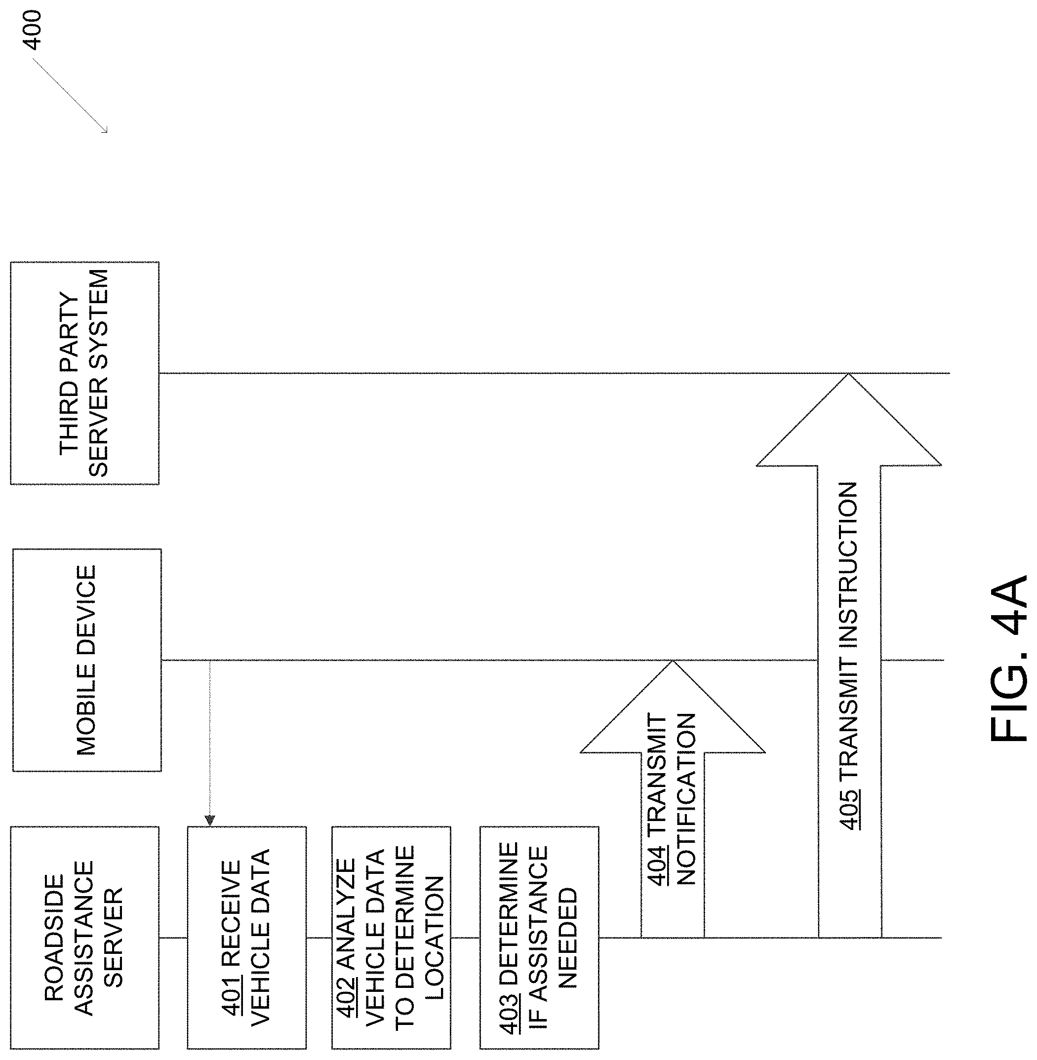
FIGS. 4A-C illustrate example events sequence for determining a location of a vehicle, determining whether the vehicle is experiencing a roadside event, and generating and transmitting notifications according to one or more aspects described herein. The sequence illustrated in FIGS. 4A-C are merely example sequences and various other events may be included, or events shown may be omitted, without departing from the invention. Further, one or more processes shown and/or described with respect to FIGS. 4A-C may be performed in real-time or near real-time.
With reference to event sequence 400 shown in FIG. 4A, in step 401, vehicle data may be received by a roadside assistance server from one or more sensors in a mobile device located within (or near) a vehicle. The vehicle data received may include signals or other electronic transmissions including location data, such as GPS data, and data regarding the operational state of the vehicle.
In step 402, the roadside assistance server may analyze the received vehicle data to determine a location of the vehicle (e.g., based on the GPS data) and/or the operational state of the vehicle. For example, the roadside assistance server may determine whether the vehicle is stopped for an urgent situation reason (e.g., flat tire, out of gas, mechanical issue, etc.) or a non-urgent situation reason (e.g., missed exit, looking for information about area, or the like). In some examples, the roadside assistance server may determine whether one or more diagnostic codes have been activated. If no diagnostic codes are activated, the roadside assistance server may determine that the vehicle is stopped for a non-urgent situation reason. Data received regarding other vehicles can be utilized to determine whether those vehicles are also stopped (e.g., due to traffic, accident in the area, etc.). If other vehicles are also stopped, the vehicle may be stopped for a non-urgent situation reason. If the other vehicles are still moving (e.g., are moving a predetermined threshold amount faster than the vehicle being evaluated) the roadside assistance server may determine that the vehicle is stopped for an urgent situation reason.
In step 403, the roadside assistance server may determine whether roadside assistance may be required for the vehicle. For example, the roadside assistance server may determine whether the determined location is within a threshold distance (e.g., 10 feet, 100 feet, or the like) of a highway and/or the vehicle is parked along a busy street and/or has its hazard lights engaged based on processing audio data captured by the mobile device. In some examples, this determination may be made by comparing the received GPS data with known map data. In a variety of embodiments, the known map data may include a risk map describing the conditions of the geographic area. In a variety of embodiments, the geographic area is determined by utilizing machine learning techniques to process map and/or satellite images to determine a probability vector describing the geographic location. The geographic location can include a variety of usual parking locations (parking lots, residential streets, etc.) and unusual parking locations (highways, remote roads, etc.) and the probability vector can describe the likelihood that a particular location is a usual or unusual parking location. In many embodiments, the determination if roadside assistance is needed is based on determining if the vehicle has a flat tire. A variety of sensor data captured using any of a variety of sensors, such as gyroscopes, accelerometers, and magnetometers, can be utilized to measure the vibration of a vehicle to determine if the vehicle has a flat tire and/or a tire with low air pressure. In several embodiments, machine learning techniques can be utilized to calculate one or more probability vectors describing the likelihood that the vehicle has one or more low or flat tires. Additionally, the sensor data can be utilized to calculate the vehicle's pull over pattern. In several embodiments, machine learning techniques can be utilized to calculate one or more probability vectors describing the likelihood that the vehicle pulled over to the side of a road in a manner corresponding to an emergency stop.
In steps 404 and 405, one or more notifications can be provided to the mobile device and/or third-party server systems. Notifications provided to the mobile device can elicit additional information from the occupants of the vehicle, while notifications provided to third-party server systems can be utilized to provide updates regarding the operational status of the vehicle and/or request roadside assistance be provided as described in more detail herein. The type of notification generated may be based on whether the vehicle is determined to be stopped for an urgent situation reason or a non-urgent situation reason. In some examples, a first type of notification may be generated and transmitted to the mobile device in step 404 if the vehicle is stopped for an urgent situation reason. Further, if the vehicle is stopped for an urgent reason, a notification and request for assistance may be transmitted to a third party server system in step 405. The request may include a location of the vehicle, a description of the issue, and the like. Additionally, the roadside assistance server may generate a notification that is transmitted to the mobile device. The notification may include an indication that an issue has been detected and that assistance has been requested. The notification may further include an estimated time of arrival of assistance, as well as an option for the user to provide feedback or input (e.g., decline the requested assistance, request additional assistance, or the like). If the vehicle is stopped for a non-urgent situation reason, a second type of notification may be transmitted to the mobile device in step 404. The second type of notification may be different from the first type. For example, the second type of notification may include an indication that the system has recognized the vehicle is stopped and may request user input if additional assistance is required. The second type of notification may include information about an area surrounding the location of the vehicle (e.g., local points of interest, food or lodging nearby, or the like). The second type of notification may be transmitted to the mobile device via push notification, SMS, or the like.
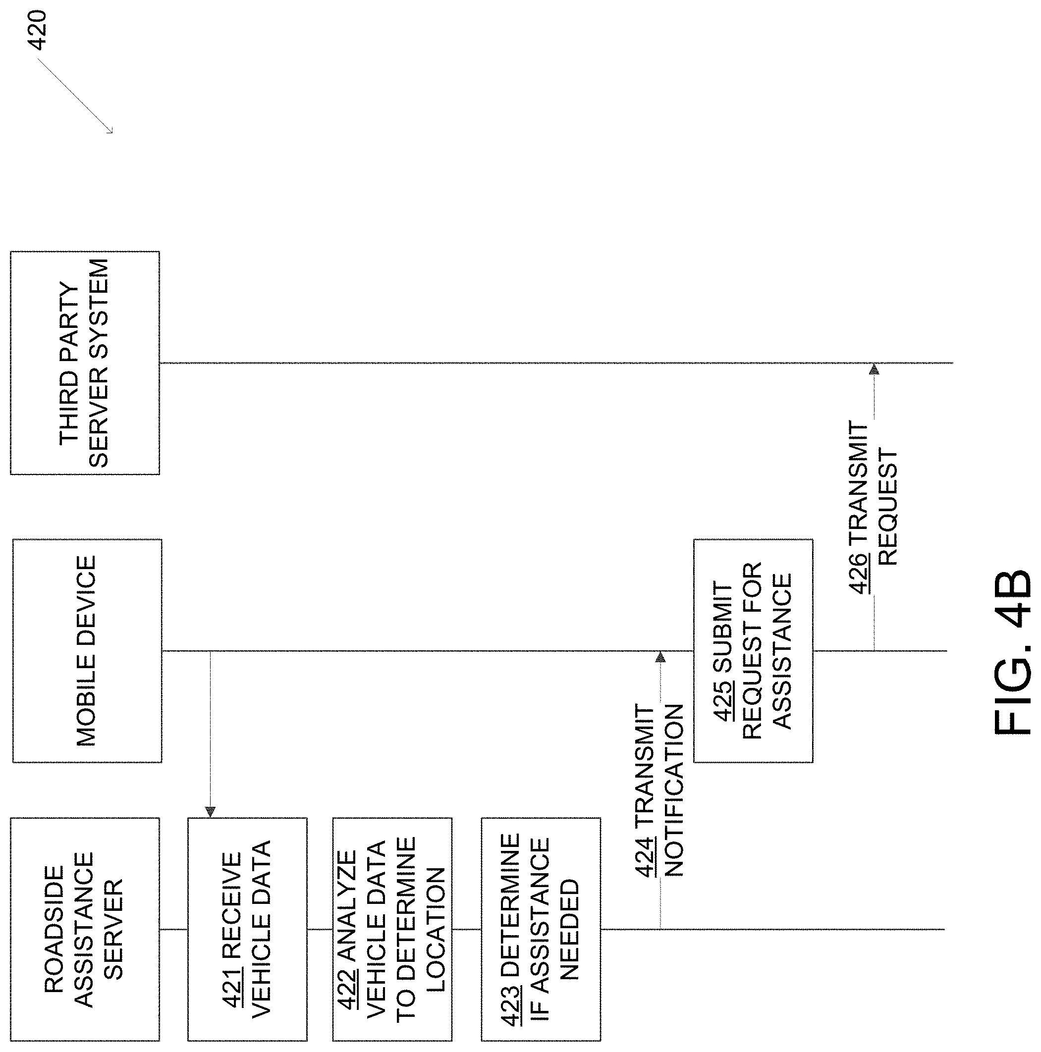
Turning now to event sequence 420 shown in FIG. 4B, in step 421, vehicle data may be received by a roadside assistance server from one or more sensors in a mobile device located within (or near) a vehicle. The vehicle data received may include signals or other electronic transmissions including location data, such as GPS data, and data regarding the operational state of the vehicle. In step 422, the roadside assistance server may analyze the received vehicle data to determine a location of the vehicle (e.g., based on the GPS data) and/or the operational state of the vehicle. In step 423, the roadside assistance server may determine whether roadside assistance may be required for the vehicle. For example, the roadside assistance server may determine whether the determined location is within a threshold distance of a highway and/or the vehicle is parked along a busy street and/or has its hazard lights engaged based on processing audio data captured by the mobile device. In some examples, this determination may be made by comparing the received GPS data with known map data. In a variety of embodiments, the known map data may include a risk map describing the conditions of the geographic area.
In step 424, one or more notifications can be provided to the mobile device. Notifications provided to the mobile device can elicit additional information from the occupants of the vehicle regarding the need for roadside assistance. If a request for roadside assistance is provided at step 425, the mobile device can transmit a request to a third-party server system in step 426. The request to the third-party server system can include a request for an emergency vehicle and/or roadside support, a request to place a call to one or more contacts obtained using the mobile device, and/or any other request as appropriate to the requirements of specific application of embodiments of the invention.
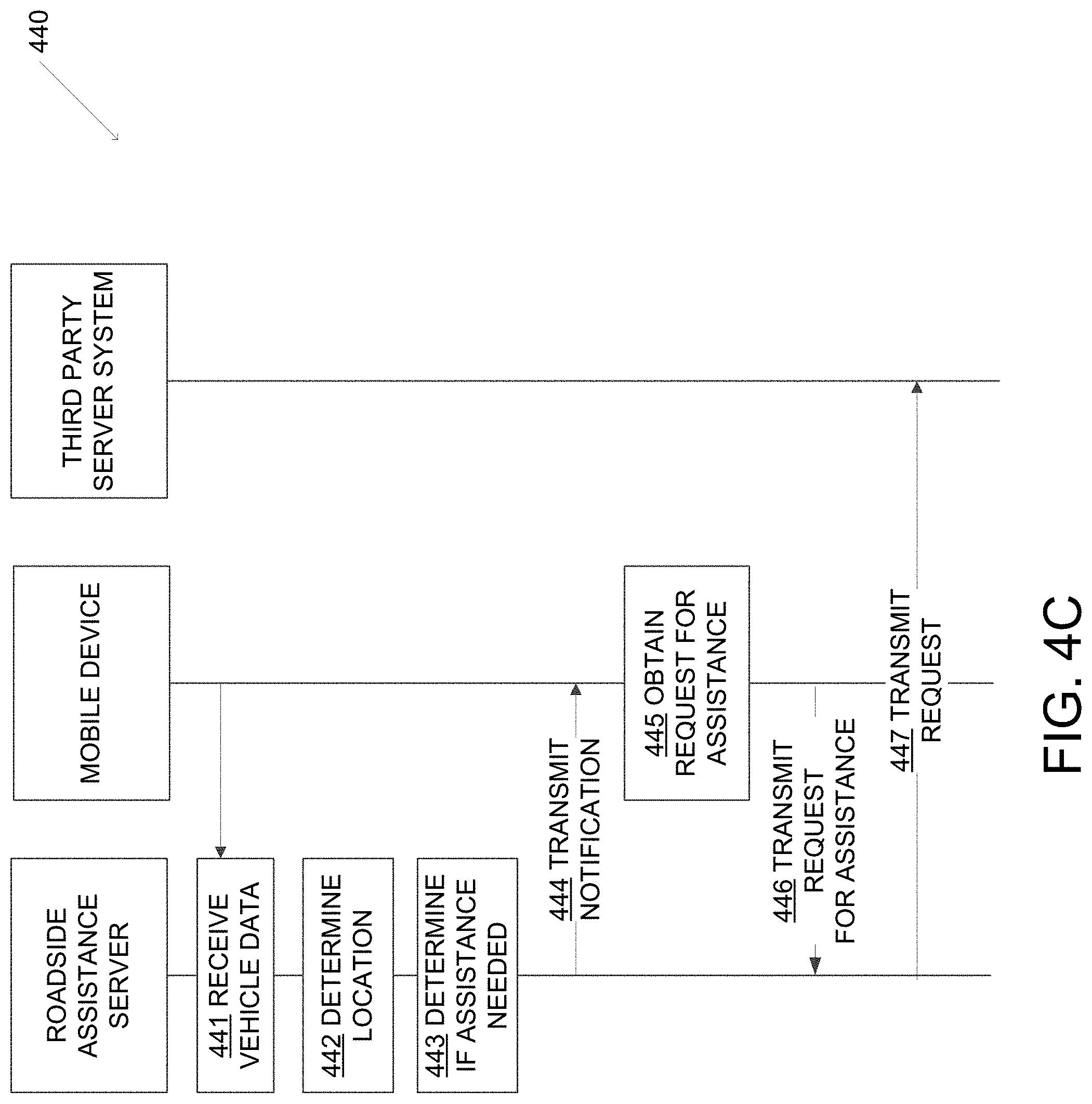
Turning now to event sequence 440 shown in FIG. 4C, in step 441, vehicle data may be received by a roadside assistance server from one or more sensors in a mobile device located within (or near) a vehicle. The vehicle data received may include signals or other electronic transmissions including location data, such as GPS data, and data regarding the operational state of the vehicle. In step 442, the roadside assistance server may analyze the received vehicle data to determine a location of the vehicle (e.g., based on the GPS data) and/or the operational state of the vehicle. In step 443, the roadside assistance server may determine whether roadside assistance may be required for the vehicle. For example, the roadside assistance server may determine whether the determined location is within a threshold distance of a highway and/or the vehicle is parked along a busy street and/or has its hazard lights engaged based on processing audio data captured by the mobile device. In some examples, this determination may be made by comparing the received GPS data with known map data. In a variety of embodiments, the known map data may include a risk map describing the conditions of the geographic area.
In step 444, one or more notifications can be provided to the mobile device. Notifications provided to the mobile device can elicit additional information from the occupants of the vehicle regarding the need for roadside assistance. If a request for roadside assistance is provided at step 445, the mobile device can transmit a request for assistance to the roadside assistance server in step 446. The roadside assistance server can determine one or more third-party server systems to transmit a request for assistance in step 447. The requests to the third-party server system can include a request for an emergency vehicle and/or roadside support, a request to place a call to one or more contacts obtained using the mobile device, and/or any other request as appropriate to the requirements of specific application of embodiments of the invention.
Although the event sequences described with respect to FIGS. 4A-C include a separate roadside assistance server and mobile device, it should be noted that all steps can be performed by either system alone or in combination. In this way, the event sequences described with respect to FIGS. 4A-C can be performed using only a mobile device and/or with cloud-based services as appropriate to the requirements of specific applications of embodiments of the invention.
Determining if a vehicle is experiencing a roadside event can include obtaining and processing a variety of data regarding a vehicle. In a variety of embodiments, this data is captured using one or more mobile devices located within the vehicle. A variety of data can be captured regarding the operational state, location, and/or surrounding environment of the vehicle (e.g. vehicle status). The operational state of the vehicle can include determining if the vehicle is moving, how fast the vehicle is moving, the acceleration/deceleration of the vehicle, and/or if the vehicle is stopped. In several embodiments, the operational state of the vehicle is determined using one or more sensors, such as but not limited to accelerometers, GPS receivers, and/or gyroscopes, located within a mobile device. The location of the vehicle can be determined using any of a variety of techniques, including using a GPS receiver to determine the geographic location of the vehicle. In a number of embodiments, the location of the vehicle is based on a risk map identifying characteristics of a particular geographic location. Data describing the state of the environment the vehicle is located in can be captured using a variety of sensors, such as but not limited to microphones and camera. In many embodiments, audio data is captured using a microphone and processed to determine one or more characteristics present within the audio data. These characteristics can include, but are not limited to, determining if the vehicle is located in an environment with traffic noise (thereby indicating that the vehicle may be stopped alongside a roadway with moving traffic) and determining if the hazard lights in the vehicle have been activated (thereby indicating that the driver has determined that an emergency stop was needed). In several embodiments, machine learning techniques are utilized to process the audio data to calculate one or more feature vectors within the audio data, where a feature vector identifies one or more characteristic audio signals within the audio data. These feature vectors can be binary and/or expressed as a probabilistic likelihood of being present to allow for the classification of vehicle events based on the audio data. Similarly, image and/or video data can be captured using a camera located in a mobile device and processed using a variety of image processing techniques. The characteristics identified in the audio data can be processed along with the vehicle location and/or operational status to determine if a vehicle event is occurring, the severity of the vehicle event, and/or if roadside assistance may be needed. In some examples, the determination of the operational status may be based on a scan of diagnostic codes activated in the vehicle.
Depending on the specifics of the vehicle event, one or more notifications can be generated and provided to the mobile device. These notifications can solicit additional information from the user of the vehicle, provide information to the user, and/or request roadside assistance from one or more third-party systems. In a variety of embodiments, phone calls and/or SMS messages can be provided to one or more contacts--the contacts may be pre-determined and/or selected from a contact list stored on the mobile device. The requests for roadside assistance can be made based on information provided by the user, the location of the vehicle, and/or the determined type of vehicle event. For example, if it is determined that the vehicle has a flat tire, a roadside assistance service may be notified, while if it is determined that the vehicle is on fire, emergency services may be notified. The request for roadside assistance can include data regarding the vehicle event, the location of the vehicle, and/or any other data as appropriate to the requirements of specific applications of embodiments of the invention.
Turning now to FIG. 5, a process for requesting roadside assistance in accordance with an embodiment of the invention is shown. The process 500 includes determining (510) a vehicle state, determining (512) a vehicle location, obtaining (514) vehicle status data, providing (516) vehicle data, obtaining (518) notification data, and, in many embodiments, requesting (520) roadside assistance.
Turning now to FIG. 6, a process for processing a vehicle event in accordance with an embodiment of the invention is shown. The process 600 includes obtaining (610) vehicle status data, determining (612) a vehicle location, determining (614) if the vehicle is experiencing an emergency event, and transmitting (616) notification data. In many embodiments, assistance request data is obtained (618) and/or roadside assistance notifications are transmitted (620).
In many embodiments, determining if a vehicle is experiencing an emergency includes determining when a vehicle stops during a trip. When the vehicle stops, an origin point can be established. In a number of embodiments, a mobile device is used to determine when a vehicle is in a trip, when the vehicle stops, and/or establish the origin point using a location determination device in the mobile device. Once a vehicle is stopped, the mobile device can be utilized to determine the location of the user. In many embodiments, the mobile device is utilized to determine the location of the user proximate to the origin point once the vehicle has been stopped for a threshold amount of time. This amount of time can be pre-determined and/or determined dynamically based on the origin point. In a number of embodiments, a geo-fence is determined based on the origin point and the location of the user can be determined relative to the geo-fence. If the user is within the geo-fence they can be considered to be staying with the car, while if they leave the geo-fence it can be determined that the user has left the vehicle. In several embodiments, map data, satellite images, and/or reverse geo-code information can be obtained from one or more third-party server systems based on the origin point. As described herein, a variety of machine learning techniques can be utilized to determine attributes of the geographic location in which the vehicle has stopped. A variety of data captured using the mobile device can also be utilized to determine conditions of the vehicle when the vehicle stopped. As described herein, these vehicle conditions can include determining if the vehicle hazard lights are on, if the vehicle has a flat tire, and/or if the vehicle pulled over in a manner consistent with an emergency stop. The usage of the mobile device and/or location of the user relative to the vehicle can also be utilized in conjunction with the condition of the vehicle in determining if the vehicle is in need of roadside assistance. In several embodiments, one or more of the above factors can be weighted and/or a confidence score can be calculate using a variety of techniques, including machine learning techniques. When the confidence score exceeds a threshold value (which can be determined dynamically and/or predetermined), a request for roadside assistance can be initiated.
Turning now to FIG. 7, a process for determining of a vehicle is experiencing an emergency in accordance with an embodiment of the invention is shown. Process 700 includes determining (710) if a vehicle has stopped, calculating (712) vehicle geo-fence data, obtaining (714) contextual location data, validating (716) a parking location, generating (718) environmental data, and calculating (720) an emergency stop score.
User Interfaces
FIG. 8A illustrates one example user interface including a notification of the first type. The interface 800 is one example of a notification and additional or alternative information may be provided in a first notification without departing from the invention. Interface 800 includes an indication that a vehicle event has occurred in a location where roadside assistance may be desired. In addition, the interface 800 requests a confirmation for a request for roadside assistance to be made. If a user does not wish to accept the requested roadside assistance (e.g., can repair the issue themselves, has already requested assistance, or the like), the user may select "No Thanks" option and the system will transmit an instruction cancelling the requested roadside assistance. FIG. 8B illustrates an example user interface 850 including a second type of notification. The second type of notification may include one or more selections available to the user. For example, the second type of notification 850 may include a request for the user to confirm that everyone is OK, a selectable offer for the system to request roadside assistance, and/or a selectable option to view additional information about an area surrounding the location (e.g., food, lodging, points of interest, and the like). More or fewer options may be provided to the user as appropriate to the requirements of specific applications of embodiments of the invention. The election of one or more options available via user interface 850 may cause display of a second user interface having additional information, offers for assistance, or the like.
As discussed herein, the systems, arrangements, methods and the like, described herein provide an efficient and accurate system for monitoring vehicles to detect issues that have caused the vehicle to stop. In some arrangements, the system may receive and/or process data in real-time in order to effectively and accurately identify vehicles that are stopped, determine a reason for stopping, and the like.
In some examples, a user may register their vehicle in order to engage the monitoring aspect of the system. Registration may be performed via an online or mobile application executing one or more computing devices. Registration may include a user providing information about the vehicle (e.g., make, model, year, etc.), potential drivers (e.g., name, contact information, and the like). In some examples, the registration process may also include options for initiating the processes or systems described herein. For example, the registration process may include an option for "always on" which means the system may monitor the vehicle at all times to detect when the vehicle is on a highway, etc. In other examples, the user may select to have the system activate or initiate upon detecting a speed of the vehicle above a predetermined threshold (e.g., greater than 40 MPH, 50 MPH, 60 MPH, or the like, for a predetermined time). In another example, the system may activate or initiate upon a vehicle location being detected as on a highway or upon navigation information indicating that a user will be using a highway along a predetermined route. In still another example, a user may manually activate the system when approaching or planning to drive on a highway (e.g., via an online or mobile application). Various other arrangements for activating or initiating the system may be used without departing from the invention.
The arrangements described herein provide for receiving and processing data in real-time to efficiently and accurately detect stopped vehicles, determine whether the vehicle is stopped for an urgent or non-urgent situation reason, and provide assistance accordingly.
Various aspects described herein may be embodied as a method, an apparatus, or as one or more computer-readable media storing computer-executable instructions. Accordingly, those aspects may take the form of an entirely hardware embodiment, an entirely software embodiment, or an embodiment combining software and hardware aspects. Any and/or all of the method steps described herein may be embodied in computer-executable instructions stored on a computer-readable medium, such as a non-transitory computer readable medium. Any and/or all of the method steps described herein may be embodied in computer-readable instructions stored in the memory of an apparatus that includes one or more processors, such that the apparatus is caused to perform such method steps when the one or more processors execute the computer-readable instructions. In addition, various signals representing data or events as described herein may be transferred between a source and a destination in the form of light and/or electromagnetic waves traveling through signal-conducting media such as metal wires, optical fibers, and/or wireless transmission media (e.g., air and/or space).
Aspects of the disclosure have been described in terms of illustrative embodiments thereof. Numerous other embodiments, modifications, and variations within the scope and spirit of the appended claims will occur to persons of ordinary skill in the art from a review of this disclosure. For example, one of ordinary skill in the art will appreciate that the steps illustrated in the illustrative figures may be performed in other than the recited order, and that one or more steps illustrated may be optional in accordance with aspects of the disclosure. Further, one or more aspects described with respect to one figure or arrangement may be used in conjunction with other aspects associated with another figure or portion of the description.
* * * * *
D00000
D00001
D00002
D00003
D00004
D00005
D00006
D00007
D00008
D00009
D00010
D00011
XML
uspto.report is an independent third-party trademark research tool that is not affiliated, endorsed, or sponsored by the United States Patent and Trademark Office (USPTO) or any other governmental organization. The information provided by uspto.report is based on publicly available data at the time of writing and is intended for informational purposes only.
While we strive to provide accurate and up-to-date information, we do not guarantee the accuracy, completeness, reliability, or suitability of the information displayed on this site. The use of this site is at your own risk. Any reliance you place on such information is therefore strictly at your own risk.
All official trademark data, including owner information, should be verified by visiting the official USPTO website at www.uspto.gov. This site is not intended to replace professional legal advice and should not be used as a substitute for consulting with a legal professional who is knowledgeable about trademark law.