Interactive vehicle information mapping system
Dorne , et al. Oc
U.S. patent number 10,460,602 [Application Number 15/633,313] was granted by the patent office on 2019-10-29 for interactive vehicle information mapping system. This patent grant is currently assigned to Palantir Technologies Inc.. The grantee listed for this patent is Palantir Technologies Inc.. Invention is credited to Andrew Dorne, Ranajay Sen, Kevin Whelan.


View All Diagrams
| United States Patent | 10,460,602 |
| Dorne , et al. | October 29, 2019 |
Interactive vehicle information mapping system
Abstract
An interactive vehicle information map system is disclosed in which, in various embodiments, geographical, geospatial, vehicle, and other types of data, geodata, objects, features, and/or metadata are efficiently presented to a user on an interactive map interface. The user may search vehicle-related data based on multiple sets of search criteria including, for example, information regarding one or more geographic area, one or more time period, one or more vehicle, one or more vehicle owner, and/or one or more license plate number, among other items. The map system may further include an interactive timeline and/or an interactive heatmap.
| Inventors: | Dorne; Andrew (San Francisco, CA), Whelan; Kevin (Palo Alto, CA), Sen; Ranajay (Palo Alto, CA) | ||||||||||
|---|---|---|---|---|---|---|---|---|---|---|---|
| Applicant: |
|
||||||||||
| Assignee: | Palantir Technologies Inc.
(Palo Alto, CA) |
||||||||||
| Family ID: | 68315022 | ||||||||||
| Appl. No.: | 15/633,313 | ||||||||||
| Filed: | June 26, 2017 |
Related U.S. Patent Documents
| Application Number | Filing Date | Patent Number | Issue Date | ||
|---|---|---|---|---|---|
| 62439637 | Dec 28, 2016 | ||||
| Current U.S. Class: | 1/1 |
| Current CPC Class: | G08G 1/04 (20130101); G08G 1/127 (20130101); G07C 5/008 (20130101); G08G 1/012 (20130101); G06F 16/904 (20190101); G08G 1/13 (20130101); G08G 1/0175 (20130101); G08G 1/123 (20130101); G08G 1/20 (20130101) |
| Current International Class: | G08G 1/13 (20060101); G08G 1/123 (20060101); G08G 1/127 (20060101); G07C 5/00 (20060101); G08G 1/00 (20060101); G06F 15/16 (20060101) |
| Field of Search: | ;701/33.4 |
References Cited [Referenced By]
U.S. Patent Documents
| 4899161 | February 1990 | Morin et al. |
| 4958305 | September 1990 | Piazza |
| 5109399 | April 1992 | Thompson |
| 5329108 | July 1994 | Lamoure |
| 5632009 | May 1997 | Rao et al. |
| 5670987 | September 1997 | Doi et al. |
| 5754182 | May 1998 | Kobayashi |
| 5781195 | July 1998 | Marvin |
| 5781704 | July 1998 | Rossmo |
| 5798769 | August 1998 | Chiu et al. |
| 5845300 | December 1998 | Comer |
| 6057757 | May 2000 | Arrowsmith et al. |
| 6091956 | July 2000 | Hollenberg |
| 6157747 | December 2000 | Szeliski et al. |
| 6161098 | December 2000 | Wallman |
| 6173067 | January 2001 | Payton et al. |
| 6178432 | January 2001 | Cook et al. |
| 6219053 | April 2001 | Tachibana et al. |
| 6232971 | May 2001 | Haynes |
| 6247019 | June 2001 | Davies |
| 6279018 | August 2001 | Kudrolli et al. |
| 6341310 | January 2002 | Leshem et al. |
| 6366933 | April 2002 | Ball et al. |
| 6369835 | April 2002 | Lin |
| 6389289 | May 2002 | Voce et al. |
| 6414683 | July 2002 | Gueziec |
| 6456997 | September 2002 | Shukla |
| 6483509 | November 2002 | Rabenhorst |
| 6529900 | March 2003 | Patterson et al. |
| 6549944 | April 2003 | Weinberg et al. |
| 6560620 | May 2003 | Ching |
| 6581068 | June 2003 | Bensoussan et al. |
| 6594672 | July 2003 | Lampson et al. |
| 6631496 | October 2003 | Li et al. |
| 6642945 | November 2003 | Sharpe |
| 6662103 | December 2003 | Skolnick et al. |
| 6674434 | January 2004 | Chojnacki et al. |
| 6714936 | March 2004 | Nevin, III |
| 6757445 | June 2004 | Knopp |
| 6775675 | August 2004 | Nwabueze et al. |
| 6828920 | December 2004 | Owen et al. |
| 6839745 | January 2005 | Dingari et al. |
| 6877137 | April 2005 | Rivette et al. |
| 6976210 | December 2005 | Silva et al. |
| 6980984 | December 2005 | Huffman et al. |
| 6985950 | January 2006 | Hanson et al. |
| 7036085 | April 2006 | Barros |
| 7043702 | May 2006 | Chi et al. |
| 7055110 | May 2006 | Kupka et al. |
| 7139800 | November 2006 | Bellotti et al. |
| 7158878 | January 2007 | Rasmussen et al. |
| 7162475 | January 2007 | Ackerman |
| 7168039 | January 2007 | Bertram |
| 7171427 | January 2007 | Witowski et al. |
| 7269786 | September 2007 | Malloy et al. |
| 7278105 | October 2007 | Kitts |
| 7290698 | November 2007 | Poslinski et al. |
| 7333998 | February 2008 | Heckerman et al. |
| 7370047 | May 2008 | Gorman |
| 7375732 | May 2008 | Arcas |
| 7379811 | May 2008 | Rasmussen et al. |
| 7379903 | May 2008 | Caballero et al. |
| 7426654 | September 2008 | Adams et al. |
| 7454466 | November 2008 | Bellotti et al. |
| 7457706 | November 2008 | Malero et al. |
| 7467375 | December 2008 | Tondreau et al. |
| 7487139 | February 2009 | Fraleigh et al. |
| 7502786 | March 2009 | Liu et al. |
| 7519470 | April 2009 | Brasche et al. |
| 7525422 | April 2009 | Bishop et al. |
| 7529195 | May 2009 | Gorman |
| 7529727 | May 2009 | Arning et al. |
| 7529734 | May 2009 | Dirisala |
| 7539666 | May 2009 | Ashworth et al. |
| 7546245 | June 2009 | Surpin et al. |
| 7558677 | July 2009 | Jones |
| 7574409 | August 2009 | Patinkin |
| 7574428 | August 2009 | Leiserowitz et al. |
| 7579965 | August 2009 | Bucholz |
| 7596285 | September 2009 | Brown et al. |
| 7614006 | November 2009 | Molander |
| 7617232 | November 2009 | Gabbert et al. |
| 7620628 | November 2009 | Kapur et al. |
| 7627812 | December 2009 | Chamberlain et al. |
| 7634717 | December 2009 | Chamberlain et al. |
| 7640173 | December 2009 | Surpin et al. |
| 7663621 | February 2010 | Allen et al. |
| 7703021 | April 2010 | Flam |
| 7706817 | April 2010 | Bamrah et al. |
| 7712049 | May 2010 | Williams et al. |
| 7716067 | May 2010 | Surpin et al. |
| 7716077 | May 2010 | Mikurak |
| 7725530 | May 2010 | Sah et al. |
| 7725547 | May 2010 | Albertson et al. |
| 7730082 | June 2010 | Sah et al. |
| 7730109 | June 2010 | Rohrs et al. |
| 7770100 | August 2010 | Chamberlain et al. |
| 7791616 | September 2010 | Ioup et al. |
| 7805457 | September 2010 | Viola et al. |
| 7809703 | October 2010 | Balabhadrapatruni et al. |
| 7818658 | October 2010 | Chen |
| 7870493 | January 2011 | Pall et al. |
| 7872647 | January 2011 | Mayer et al. |
| 7894984 | February 2011 | Rasmussen et al. |
| 7899611 | March 2011 | Downs et al. |
| 7917376 | March 2011 | Bellin et al. |
| 7920963 | April 2011 | Jouline et al. |
| 7933862 | April 2011 | Chamberlain et al. |
| 7945852 | May 2011 | Pilskains |
| 7962281 | June 2011 | Rasmussen et al. |
| 7962495 | June 2011 | Jain et al. |
| 7962848 | June 2011 | Bertram |
| 7970240 | June 2011 | Chao et al. |
| 7971150 | June 2011 | Raskutti et al. |
| 7984374 | July 2011 | Caro et al. |
| 8001465 | August 2011 | Kudrolli et al. |
| 8001482 | August 2011 | Bhattiprolu et al. |
| 8010545 | August 2011 | Stefik et al. |
| 8010886 | August 2011 | Gusmorino et al. |
| 8015487 | September 2011 | Roy et al. |
| 8019709 | September 2011 | Norton et al. |
| 8024778 | September 2011 | Cash et al. |
| 8036632 | October 2011 | Cona et al. |
| 8065080 | November 2011 | Koch |
| 8082172 | December 2011 | Chao et al. |
| 8085268 | December 2011 | Carrino et al. |
| 8103543 | January 2012 | Zwicky |
| 8134457 | March 2012 | Velipasalar et al. |
| 8145703 | March 2012 | Frishert et al. |
| 8185819 | May 2012 | Sah et al. |
| 8214361 | July 2012 | Sandler et al. |
| 8214764 | July 2012 | Gemmell et al. |
| 8225201 | July 2012 | Michael |
| 8229947 | July 2012 | Fujinaga |
| 8230333 | July 2012 | Decherd et al. |
| 8271461 | September 2012 | Pike et al. |
| 8280880 | October 2012 | Aymeloglu et al. |
| 8290926 | October 2012 | Ozzie et al. |
| 8290942 | October 2012 | Jones et al. |
| 8301464 | October 2012 | Cave et al. |
| 8301904 | October 2012 | Gryaznov |
| 8312367 | November 2012 | Foster |
| 8312546 | November 2012 | Alme |
| 8325178 | December 2012 | Doyle, Jr. |
| 8352881 | January 2013 | Champion et al. |
| 8368695 | February 2013 | Howell et al. |
| 8397171 | March 2013 | Klassen et al. |
| 8400448 | March 2013 | Doyle, Jr. |
| 8407180 | March 2013 | Ramesh et al. |
| 8411046 | April 2013 | Kruzeniski et al. |
| 8412234 | April 2013 | Gatmir-Motahari et al. |
| 8412707 | April 2013 | Mianji |
| 8422825 | April 2013 | Neophytou et al. |
| 8447722 | May 2013 | Ahuja et al. |
| 8452790 | May 2013 | Mianji |
| 8463036 | June 2013 | Ramesh et al. |
| 8489331 | July 2013 | Kopf et al. |
| 8489641 | July 2013 | Seefeld et al. |
| 8498984 | July 2013 | Hwang et al. |
| 8508533 | August 2013 | Cervelli et al. |
| 8510743 | August 2013 | Hackborn et al. |
| 8514082 | August 2013 | Cova et al. |
| 8514229 | August 2013 | Cervelli et al. |
| 8515207 | August 2013 | Chau |
| 8554579 | October 2013 | Tribble et al. |
| 8554653 | October 2013 | Falkenborg et al. |
| 8554709 | October 2013 | Goodson et al. |
| 8554840 | October 2013 | Milgramm |
| 8564596 | October 2013 | Carrino et al. |
| 8577911 | November 2013 | Stepinski et al. |
| 8589273 | November 2013 | Creeden et al. |
| 8595234 | November 2013 | Siripuapu et al. |
| 8620641 | December 2013 | Farnsworth et al. |
| 8639757 | January 2014 | Zang et al. |
| 8646080 | February 2014 | Williamson et al. |
| 8676597 | March 2014 | Buehler et al. |
| 8676857 | March 2014 | Adams et al. |
| 8689108 | April 2014 | Duffield et al. |
| 8707185 | April 2014 | Robinson et al. |
| 8713467 | April 2014 | Goldenberg et al. |
| 8726379 | May 2014 | Stiansen et al. |
| 8739278 | May 2014 | Varghese |
| 8742934 | June 2014 | Sarpy et al. |
| 8745516 | June 2014 | Mason et al. |
| 8756244 | June 2014 | Dassa et al. |
| 8768009 | July 2014 | Smith |
| 8781169 | July 2014 | Jackson et al. |
| 8787939 | July 2014 | Papakipos et al. |
| 8799799 | August 2014 | Cervelli et al. |
| 8799812 | August 2014 | Parker |
| 8812960 | August 2014 | Sun et al. |
| 8830322 | September 2014 | Nerayoff et al. |
| 8832594 | September 2014 | Thompson et al. |
| 8868486 | October 2014 | Tamayo |
| 8868537 | October 2014 | Colgrove et al. |
| 8917274 | December 2014 | Ma et al. |
| 8924872 | December 2014 | Bogomolov et al. |
| 8937619 | January 2015 | Sharma et al. |
| 8938686 | January 2015 | Erenrich et al. |
| 9009171 | April 2015 | Grossman et al. |
| 9009827 | April 2015 | Albertson et al. |
| 9021260 | April 2015 | Falk et al. |
| 9021384 | April 2015 | Beard et al. |
| 9043696 | May 2015 | Meiklejohn et al. |
| 9043894 | May 2015 | Dennison et al. |
| 10042524 | August 2018 | Bogomolov et al. |
| 10262047 | April 2019 | Stowe et al. |
| 2001/0021936 | September 2001 | Bertram |
| 2002/0003539 | January 2002 | Abe |
| 2002/0033848 | March 2002 | Sciammarella et al. |
| 2002/0065708 | May 2002 | Senay et al. |
| 2002/0091707 | July 2002 | Keller |
| 2002/0095658 | July 2002 | Shulman |
| 2002/0116120 | August 2002 | Ruiz et al. |
| 2002/0130867 | September 2002 | Yang et al. |
| 2002/0130907 | September 2002 | Chi et al. |
| 2002/0174201 | November 2002 | Ramer et al. |
| 2002/0194119 | December 2002 | Wright et al. |
| 2003/0028560 | February 2003 | Kudrolli et al. |
| 2003/0039948 | February 2003 | Donahue |
| 2003/0052896 | March 2003 | Higgins et al. |
| 2003/0061200 | March 2003 | Hubert et al. |
| 2003/0103049 | June 2003 | Kindratenko et al. |
| 2003/0140106 | July 2003 | Raguseo |
| 2003/0144868 | July 2003 | MacIntyre et al. |
| 2003/0163352 | August 2003 | Surpin et al. |
| 2003/0200217 | October 2003 | Ackerman |
| 2003/0225755 | December 2003 | Iwayama et al. |
| 2003/0229848 | December 2003 | Arend et al. |
| 2004/0030492 | February 2004 | Fox et al. |
| 2004/0032432 | February 2004 | Baynger |
| 2004/0039498 | February 2004 | Ollis et al. |
| 2004/0064256 | April 2004 | Barinek et al. |
| 2004/0085318 | May 2004 | Hassler et al. |
| 2004/0095349 | May 2004 | Bito et al. |
| 2004/0098236 | May 2004 | Mayer et al. |
| 2004/0111410 | June 2004 | Burgoon et al. |
| 2004/0126840 | July 2004 | Cheng et al. |
| 2004/0143602 | July 2004 | Ruiz et al. |
| 2004/0143796 | July 2004 | Lerner et al. |
| 2004/0163039 | August 2004 | Gorman |
| 2004/0181554 | September 2004 | Heckerman et al. |
| 2004/0193600 | September 2004 | Kaasten et al. |
| 2004/0194549 | October 2004 | Noel |
| 2004/0210847 | October 2004 | Berson et al. |
| 2004/0212518 | October 2004 | Tajima et al. |
| 2004/0221223 | November 2004 | Yu et al. |
| 2004/0260702 | December 2004 | Cragun et al. |
| 2004/0267746 | December 2004 | Marcjan et al. |
| 2005/0027705 | February 2005 | Sadri et al. |
| 2005/0028094 | February 2005 | Allyn |
| 2005/0031197 | February 2005 | Knopp |
| 2005/0034062 | February 2005 | Bufkin et al. |
| 2005/0039119 | February 2005 | Parks et al. |
| 2005/0065811 | March 2005 | Chu et al. |
| 2005/0080769 | April 2005 | Gemmell |
| 2005/0086207 | April 2005 | Heuer et al. |
| 2005/0097018 | May 2005 | Takida |
| 2005/0125715 | June 2005 | Di Franco et al. |
| 2005/0162523 | July 2005 | Darrell et al. |
| 2005/0166144 | July 2005 | Gross |
| 2005/0180330 | August 2005 | Shapiro |
| 2005/0182502 | August 2005 | Iyengar |
| 2005/0182793 | August 2005 | Keenan et al. |
| 2005/0183005 | August 2005 | Denoue et al. |
| 2005/0210409 | September 2005 | Jou |
| 2005/0246327 | November 2005 | Yeung et al. |
| 2005/0251786 | November 2005 | Citron et al. |
| 2005/0267652 | December 2005 | Allstadt et al. |
| 2006/0026120 | February 2006 | Carolan et al. |
| 2006/0026170 | February 2006 | Kreitler et al. |
| 2006/0045470 | March 2006 | Poslinski et al. |
| 2006/0059139 | March 2006 | Robinson |
| 2006/0074866 | April 2006 | Chamberlain et al. |
| 2006/0074881 | April 2006 | Vembu et al. |
| 2006/0080619 | April 2006 | Carlson et al. |
| 2006/0129746 | June 2006 | Porter |
| 2006/0139375 | June 2006 | Rasmussen et al. |
| 2006/0142949 | June 2006 | Helt |
| 2006/0146050 | July 2006 | Yamauchi |
| 2006/0149596 | July 2006 | Surpin et al. |
| 2006/0203337 | September 2006 | White |
| 2006/0218637 | September 2006 | Thomas et al. |
| 2006/0235831 | October 2006 | Adinolfi et al. |
| 2006/0241974 | October 2006 | Chao et al. |
| 2006/0242040 | October 2006 | Rader |
| 2006/0242630 | October 2006 | Koike et al. |
| 2006/0251307 | November 2006 | Florin et al. |
| 2006/0271277 | November 2006 | Hu et al. |
| 2006/0279630 | December 2006 | Aggarwal et al. |
| 2007/0011150 | January 2007 | Frank |
| 2007/0016363 | January 2007 | Huang et al. |
| 2007/0024620 | February 2007 | Muller-Fischer et al. |
| 2007/0038962 | February 2007 | Fuchs et al. |
| 2007/0057966 | March 2007 | Ohno et al. |
| 2007/0078832 | April 2007 | Ott et al. |
| 2007/0083541 | April 2007 | Fraleigh et al. |
| 2007/0094389 | April 2007 | Nussey et al. |
| 2007/0150369 | June 2007 | Zivin |
| 2007/0174760 | July 2007 | Chamberlain et al. |
| 2007/0188516 | August 2007 | Loup et al. |
| 2007/0192265 | August 2007 | Chopin et al. |
| 2007/0198571 | August 2007 | Ferguson et al. |
| 2007/0208497 | September 2007 | Downs et al. |
| 2007/0208498 | September 2007 | Barker et al. |
| 2007/0208681 | September 2007 | Bucholz |
| 2007/0208736 | September 2007 | Tanigawa et al. |
| 2007/0240062 | October 2007 | Christena et al. |
| 2007/0258642 | November 2007 | Thota |
| 2007/0266336 | November 2007 | Nojima et al. |
| 2007/0294643 | December 2007 | Kyle |
| 2008/0010605 | January 2008 | Frank |
| 2008/0016216 | January 2008 | Worley et al. |
| 2008/0040684 | February 2008 | Crump |
| 2008/0051989 | February 2008 | Welsh |
| 2008/0052142 | February 2008 | Bailey et al. |
| 2008/0077597 | March 2008 | Butler |
| 2008/0077642 | March 2008 | Carbone et al. |
| 2008/0082578 | April 2008 | Hogue et al. |
| 2008/0098085 | April 2008 | Krane et al. |
| 2008/0104019 | May 2008 | Nath |
| 2008/0126951 | May 2008 | Sood et al. |
| 2008/0140684 | June 2008 | O'Reilly et al. |
| 2008/0155440 | June 2008 | Trevor et al. |
| 2008/0162616 | July 2008 | Gross et al. |
| 2008/0163073 | July 2008 | Becker et al. |
| 2008/0192053 | August 2008 | Howell et al. |
| 2008/0195417 | August 2008 | Surpin et al. |
| 2008/0195608 | August 2008 | Clover |
| 2008/0208462 | August 2008 | Tanaka |
| 2008/0222295 | September 2008 | Robinson et al. |
| 2008/0223834 | September 2008 | Griffiths et al. |
| 2008/0228512 | September 2008 | Calkins et al. |
| 2008/0229056 | September 2008 | Agarwal et al. |
| 2008/0255973 | October 2008 | El Wade et al. |
| 2008/0263468 | October 2008 | Cappione et al. |
| 2008/0267107 | October 2008 | Rosenberg |
| 2008/0270468 | October 2008 | Mao |
| 2008/0276167 | November 2008 | Michael |
| 2008/0278311 | November 2008 | Grange et al. |
| 2008/0288306 | November 2008 | MacIntyre et al. |
| 2008/0294678 | November 2008 | Gorman et al. |
| 2008/0301643 | December 2008 | Appleton et al. |
| 2009/0002492 | January 2009 | Velipasalar et al. |
| 2009/0027418 | January 2009 | Maru et al. |
| 2009/0030915 | January 2009 | Winter et al. |
| 2009/0055251 | February 2009 | Shah et al. |
| 2009/0076845 | March 2009 | Bellin et al. |
| 2009/0077081 | March 2009 | Sarma et al. |
| 2009/0088964 | April 2009 | Schaaf et al. |
| 2009/0089273 | April 2009 | Hicks |
| 2009/0100018 | April 2009 | Roberts |
| 2009/0115786 | May 2009 | Shmiasaki et al. |
| 2009/0119309 | May 2009 | Gibson et al. |
| 2009/0125369 | May 2009 | Kloosstra et al. |
| 2009/0125459 | May 2009 | Norton et al. |
| 2009/0132921 | May 2009 | Hwangbo et al. |
| 2009/0132953 | May 2009 | Reed et al. |
| 2009/0143052 | June 2009 | Bates et al. |
| 2009/0144262 | June 2009 | White et al. |
| 2009/0144274 | June 2009 | Fraleigh et al. |
| 2009/0158185 | June 2009 | Lacevic et al. |
| 2009/0164934 | June 2009 | Bhattiprolu et al. |
| 2009/0171939 | July 2009 | Athsani et al. |
| 2009/0172511 | July 2009 | Decherd et al. |
| 2009/0174575 | July 2009 | Allen et al. |
| 2009/0177962 | July 2009 | Gusmorino et al. |
| 2009/0179892 | July 2009 | Tsuda et al. |
| 2009/0187464 | July 2009 | Bai et al. |
| 2009/0222400 | September 2009 | Kupershmidt et al. |
| 2009/0222760 | September 2009 | Halverson et al. |
| 2009/0234720 | September 2009 | George et al. |
| 2009/0249244 | October 2009 | Robinson et al. |
| 2009/0281839 | November 2009 | Lynn et al. |
| 2009/0287470 | November 2009 | Farnsworth et al. |
| 2009/0292626 | November 2009 | Oxford |
| 2010/0011282 | January 2010 | Dollard et al. |
| 2010/0042922 | February 2010 | Bradateanu et al. |
| 2010/0057716 | March 2010 | Stefik et al. |
| 2010/0063961 | March 2010 | Guiheneuf et al. |
| 2010/0070523 | March 2010 | Delgo et al. |
| 2010/0070842 | March 2010 | Aymeloglu et al. |
| 2010/0070845 | March 2010 | Facemire et al. |
| 2010/0070897 | March 2010 | Aymeloglu et al. |
| 2010/0076968 | March 2010 | Boyns et al. |
| 2010/0100963 | April 2010 | Mahaffey |
| 2010/0103124 | April 2010 | Kruzeniski et al. |
| 2010/0106420 | April 2010 | Mattikalli et al. |
| 2010/0114887 | May 2010 | Conway et al. |
| 2010/0122152 | May 2010 | Chamberlain et al. |
| 2010/0131457 | May 2010 | Heimendinger |
| 2010/0162176 | June 2010 | Dunton |
| 2010/0191563 | July 2010 | Schlaifer et al. |
| 2010/0198684 | August 2010 | Eraker et al. |
| 2010/0199225 | August 2010 | Coleman et al. |
| 2010/0228812 | September 2010 | Uomini |
| 2010/0250412 | September 2010 | Wagner |
| 2010/0280857 | November 2010 | Liu et al. |
| 2010/0293174 | November 2010 | Bennett et al. |
| 2010/0306713 | December 2010 | Geisner et al. |
| 2010/0313119 | December 2010 | Baldwin et al. |
| 2010/0318924 | December 2010 | Frankel et al. |
| 2010/0321399 | December 2010 | Ellren et al. |
| 2010/0325526 | December 2010 | Ellis et al. |
| 2010/0325581 | December 2010 | Finkelstein et al. |
| 2010/0330801 | December 2010 | Rouh |
| 2011/0022312 | January 2011 | McDonough et al. |
| 2011/0029526 | February 2011 | Knight et al. |
| 2011/0047159 | February 2011 | Baid et al. |
| 2011/0060753 | March 2011 | Shaked et al. |
| 2011/0061013 | March 2011 | Bilicki et al. |
| 2011/0074811 | March 2011 | Hanson et al. |
| 2011/0078055 | March 2011 | Faribault et al. |
| 2011/0078173 | March 2011 | Seligmann et al. |
| 2011/0093327 | April 2011 | Fordyce, III et al. |
| 2011/0106781 | May 2011 | Pearson |
| 2011/0117878 | May 2011 | Barash et al. |
| 2011/0119100 | May 2011 | Ruhl et al. |
| 2011/0137766 | June 2011 | Rasmussen et al. |
| 2011/0153384 | June 2011 | Horne et al. |
| 2011/0161096 | June 2011 | Buehler et al. |
| 2011/0167105 | July 2011 | Ramakrishnan et al. |
| 2011/0170799 | July 2011 | Carrino et al. |
| 2011/0173032 | July 2011 | Payne et al. |
| 2011/0185316 | July 2011 | Reid et al. |
| 2011/0208724 | August 2011 | Jones et al. |
| 2011/0218934 | September 2011 | Elser |
| 2011/0219450 | September 2011 | McDougal et al. |
| 2011/0225198 | September 2011 | Edwards et al. |
| 2011/0238553 | September 2011 | Raj et al. |
| 2011/0258158 | October 2011 | Resende et al. |
| 2011/0270705 | November 2011 | Parker |
| 2011/0289397 | November 2011 | Eastmond et al. |
| 2011/0289407 | November 2011 | Naik et al. |
| 2011/0289420 | November 2011 | Morioka et al. |
| 2011/0291851 | December 2011 | Whisenant |
| 2011/0310005 | December 2011 | Chen et al. |
| 2011/0314007 | December 2011 | Dassa et al. |
| 2012/0019559 | January 2012 | Siler et al. |
| 2012/0036013 | February 2012 | Neuhaus et al. |
| 2012/0036434 | February 2012 | Oberstein |
| 2012/0050293 | March 2012 | Carlhian et al. |
| 2012/0066296 | March 2012 | Appleton et al. |
| 2012/0072825 | March 2012 | Sherkin et al. |
| 2012/0079363 | March 2012 | Folting et al. |
| 2012/0084118 | April 2012 | Bai et al. |
| 2012/0105632 | May 2012 | Renkis |
| 2012/0106801 | May 2012 | Jackson |
| 2012/0117082 | May 2012 | Koperda et al. |
| 2012/0131512 | May 2012 | Takeuchi et al. |
| 2012/0144335 | June 2012 | Abeln et al. |
| 2012/0159307 | June 2012 | Chung et al. |
| 2012/0159362 | June 2012 | Brown et al. |
| 2012/0159363 | June 2012 | DeBacker et al. |
| 2012/0159399 | June 2012 | Bastide et al. |
| 2012/0170847 | July 2012 | Tsukidate |
| 2012/0173985 | July 2012 | Peppel |
| 2012/0196557 | August 2012 | Reich et al. |
| 2012/0196558 | August 2012 | Reich et al. |
| 2012/0203708 | August 2012 | Psota et al. |
| 2012/0206469 | August 2012 | Hulubei et al. |
| 2012/0208636 | August 2012 | Feige |
| 2012/0221511 | August 2012 | Gibson et al. |
| 2012/0221553 | August 2012 | Wittmer et al. |
| 2012/0221580 | August 2012 | Barney |
| 2012/0245976 | September 2012 | Kumar et al. |
| 2012/0246148 | September 2012 | Dror |
| 2012/0254129 | October 2012 | Wheeler et al. |
| 2012/0284345 | November 2012 | Costenaro et al. |
| 2012/0290879 | November 2012 | Shibuya et al. |
| 2012/0296907 | November 2012 | Long et al. |
| 2012/0311684 | December 2012 | Paulsen et al. |
| 2012/0323888 | December 2012 | Osann, Jr. |
| 2012/0330973 | December 2012 | Ghuneim et al. |
| 2013/0006426 | January 2013 | Healey et al. |
| 2013/0006725 | January 2013 | Simanek et al. |
| 2013/0006916 | January 2013 | McBride et al. |
| 2013/0018796 | January 2013 | Kolhatkar et al. |
| 2013/0021445 | January 2013 | Cossette-Pacheco et al. |
| 2013/0024202 | January 2013 | Harris et al. |
| 2013/0046635 | February 2013 | Grigg et al. |
| 2013/0046842 | February 2013 | Muntz et al. |
| 2013/0060786 | March 2013 | Serrano et al. |
| 2013/0061169 | March 2013 | Pearcy et al. |
| 2013/0073377 | March 2013 | Heath |
| 2013/0073454 | March 2013 | Busch |
| 2013/0076732 | March 2013 | Cervelli et al. |
| 2013/0078943 | March 2013 | Biage et al. |
| 2013/0097482 | April 2013 | Marantz et al. |
| 2013/0100134 | April 2013 | Cervelli et al. |
| 2013/0101159 | April 2013 | Chao et al. |
| 2013/0110822 | May 2013 | Ikeda et al. |
| 2013/0110877 | May 2013 | Bonham et al. |
| 2013/0111320 | May 2013 | Campbell et al. |
| 2013/0117651 | May 2013 | Waldman et al. |
| 2013/0150004 | June 2013 | Rosen |
| 2013/0151148 | June 2013 | Parundekar et al. |
| 2013/0151388 | June 2013 | Falkenborg et al. |
| 2013/0157234 | June 2013 | Gulli et al. |
| 2013/0166550 | June 2013 | Buchmann et al. |
| 2013/0176321 | July 2013 | Mitchell et al. |
| 2013/0179420 | July 2013 | Park et al. |
| 2013/0224696 | August 2013 | Wolfe et al. |
| 2013/0226953 | August 2013 | Markovich et al. |
| 2013/0238616 | September 2013 | Rose et al. |
| 2013/0246170 | September 2013 | Gross et al. |
| 2013/0251233 | September 2013 | Yang et al. |
| 2013/0262527 | October 2013 | Hunter et al. |
| 2013/0263019 | October 2013 | Castellanos et al. |
| 2013/0267207 | October 2013 | Hao et al. |
| 2013/0268520 | October 2013 | Fisher et al. |
| 2013/0279757 | October 2013 | Kephart |
| 2013/0282696 | October 2013 | John et al. |
| 2013/0282723 | October 2013 | Petersen et al. |
| 2013/0290011 | October 2013 | Lynn et al. |
| 2013/0290825 | October 2013 | Arndt et al. |
| 2013/0297619 | November 2013 | Chandrasekaran et al. |
| 2013/0311375 | November 2013 | Priebatsch |
| 2014/0019936 | January 2014 | Cohanoff |
| 2014/0032506 | January 2014 | Hoey et al. |
| 2014/0033010 | January 2014 | Richardt et al. |
| 2014/0040371 | February 2014 | Gurevich et al. |
| 2014/0047357 | February 2014 | Alfaro et al. |
| 2014/0059038 | February 2014 | McPherson et al. |
| 2014/0064112 | March 2014 | Das |
| 2014/0067611 | March 2014 | Adachi et al. |
| 2014/0068487 | March 2014 | Steiger et al. |
| 2014/0095273 | April 2014 | Tang et al. |
| 2014/0095509 | April 2014 | Patton |
| 2014/0108068 | April 2014 | Williams |
| 2014/0108380 | April 2014 | Gotz et al. |
| 2014/0108985 | April 2014 | Scott et al. |
| 2014/0129261 | May 2014 | Bothwell et al. |
| 2014/0149436 | May 2014 | Bahrami et al. |
| 2014/0156527 | June 2014 | Grigg et al. |
| 2014/0157172 | June 2014 | Peery et al. |
| 2014/0164502 | June 2014 | Khodorenko et al. |
| 2014/0188847 | July 2014 | Tang et al. |
| 2014/0189536 | July 2014 | Lange et al. |
| 2014/0195515 | July 2014 | Baker et al. |
| 2014/0195887 | July 2014 | Ellis et al. |
| 2014/0267294 | September 2014 | Ma |
| 2014/0267295 | September 2014 | Sharma |
| 2014/0279824 | September 2014 | Tamayo |
| 2014/0316911 | October 2014 | Gross |
| 2014/0333651 | November 2014 | Cervelli et al. |
| 2014/0337772 | November 2014 | Cervelli et al. |
| 2014/0344230 | November 2014 | Krause et al. |
| 2014/0361899 | December 2014 | Layson |
| 2015/0019394 | January 2015 | Unser et al. |
| 2015/0029176 | January 2015 | Baxter et al. |
| 2015/0046870 | February 2015 | Goldenberg et al. |
| 2015/0089424 | March 2015 | Duffield et al. |
| 2015/0100897 | April 2015 | Sun et al. |
| 2015/0100907 | April 2015 | Erenrich et al. |
| 2015/0134666 | May 2015 | Gattiker et al. |
| 2015/0169709 | June 2015 | Kara et al. |
| 2015/0169726 | June 2015 | Kara et al. |
| 2015/0170077 | June 2015 | Kara et al. |
| 2015/0178877 | June 2015 | Bogomolov et al. |
| 2015/0186821 | July 2015 | Wang et al. |
| 2015/0187036 | July 2015 | Wang et al. |
| 2015/0235266 | August 2015 | Jain |
| 2016/0105334 | April 2016 | Boe et al. |
| 2018/0005458 | January 2018 | Iehara et al. |
| 2018/0165300 | June 2018 | Okun |
| 2018/0307391 | October 2018 | Bogomolov et al. |
| 2019/0020557 | January 2019 | Chang |
| 2019/0228007 | July 2019 | Beard et al. |
| 102014103482 | Sep 2014 | DE | |||
| 102013222023 | Jan 2015 | DE | |||
| 102014215621 | Feb 2015 | DE | |||
| 0763201 | Mar 1997 | EP | |||
| 1672527 | Jun 2006 | EP | |||
| 2551799 | Jan 2013 | EP | |||
| 2560134 | Feb 2013 | EP | |||
| 2575107 | Apr 2013 | EP | |||
| 2778913 | Sep 2014 | EP | |||
| 2778977 | Sep 2014 | EP | |||
| 2778983 | Sep 2014 | EP | |||
| 2779082 | Sep 2014 | EP | |||
| 2835745 | Feb 2015 | EP | |||
| 2835770 | Feb 2015 | EP | |||
| 2838039 | Feb 2015 | EP | |||
| 2846241 | Mar 2015 | EP | |||
| 2851852 | Mar 2015 | EP | |||
| 2858014 | Apr 2015 | EP | |||
| 2858018 | Apr 2015 | EP | |||
| 2863326 | Apr 2015 | EP | |||
| 2863346 | Apr 2015 | EP | |||
| 2869211 | May 2015 | EP | |||
| 2881868 | Jun 2015 | EP | |||
| 2884439 | Jun 2015 | EP | |||
| 2884440 | Jun 2015 | EP | |||
| 2891992 | Jul 2015 | EP | |||
| 2516155 | Jan 2015 | GB | |||
| 2518745 | Apr 2015 | GB | |||
| 2012778 | Nov 2014 | NL | |||
| 2013306 | Feb 2015 | NL | |||
| 624557 | Dec 2014 | NZ | |||
| WO 95/032424 | Nov 1995 | WO | |||
| WO 2000/009529 | Feb 2000 | WO | |||
| WO 2002/065353 | Aug 2002 | WO | |||
| WO 2004/057268 | Jul 2004 | WO | |||
| WO 2005/013200 | Feb 2005 | WO | |||
| WO 2005/104736 | Nov 2005 | WO | |||
| WO 2008/064207 | May 2008 | WO | |||
| WO 2009/061501 | May 2009 | WO | |||
| WO 2009/123975 | Oct 2009 | WO | |||
| WO 2010/000014 | Jan 2010 | WO | |||
| WO 2010/030913 | Mar 2010 | WO | |||
| WO 2011/058507 | May 2011 | WO | |||
| WO 2013/010157 | Jan 2013 | WO | |||
| WO 2013/102892 | Jul 2013 | WO | |||
Other References
|
"A First Look: Predicting Market Demand for Food Retail using a Huff Analysis," TRF Policy Solutions, Jul. 2012, pp. 30. cited by applicant . "A Quick Guide to UniProtKB Swiss-Prot & TrEMBL," Sep. 2011, pp. 2. cited by applicant . "A Word About Banks and the Laundering of Drug Money," Aug. 18, 2012, http://www.golemxiv.co.uk/2012/08/a-word-about-banks-and-the-laundering-o- f-drug-money/. cited by applicant . Acklen, Laura, "Absolute Beginner's Guide to Microsoft Word 2003," Dec. 24, 2003, pp. 15-18, 34-41, 308-316. cited by applicant . Amnet, "5 Great Tools for Visualizing Your Twitter Followers," posted Aug. 4, 2010, http://www.amnetblog.com/component/content/article/115-5-grate-t- ools-for-visualizing-your-twitter-followers.html. cited by applicant . Ananiev et al., "The New Modality API," http://web.archive.org/web/20061211011958/http://java.sun.com/developer/t- echnicalArticles/J2SE/Desktop/javase6/modality/ Jan. 21, 2006, pp. 8. cited by applicant . "Andy Turner's GISRUK 2012 Notes" <https://docs.google.com/document/d/1cTmxg7mVx5gd89lqblCYvCEnHA4QAivH4- l4WpyPsqE4/edit?pli=1> printed Sep. 16, 2013 in 15 pages. cited by applicant . Barnes et al., "Viewshed Analysis", GIS-ARC/INFO 2001, <www.evsc.virginia.edu/.about.jhp7e/evsc466/student_pres/Rounds.pdf>- ;. cited by applicant . Bluttman et al., "Excel Formulas and Functions for Dummies," 2005, Wiley Publishing, Inc., pp. 280, 284-286. cited by applicant . Boyce, Jim, "Microsoft Outlook 2010 Inside Out," Aug. 1, 2010, retrieved from the internet https://capdtron.files.wordpress.com/2013/01/outlook-2010-inside_out.pdf. cited by applicant . Bugzilla@Mozilla, "Bug 18726--[feature] Long-click means of invoking contextual menus not supported," http://bugzilla.mozilla.org/show_bug.cgi?id=18726 printed Jun. 13, 2013 in 11 pages. cited by applicant . Canese et al., "Chapter 2: PubMed: The Bibliographic Database," The NCBI Handbook, Oct. 2002, pp. 1-10. cited by applicant . Carver et al., "Real-Time Visibility Analysis and Rapid Viewshed Calculation Using a Voxel-Based Modelling Approach," GISRUK 2012 Conference, Apr. 11-13, Lancaster UK, Apr. 13, 2012, pp. 6. cited by applicant . Celik, Tantek, "CSS Basic User Interface Module Level 3 (CSS3 UI)," Section 8 Resizing and Overflow, Jan. 17, 2012, retrieved from internet http://www.w3.org/TR/2012/WD-css3-ui-20120117/#resizing-amp-overflow retrieved on May 18, 2015. cited by applicant . Chen et al., "Bringing Order to the Web: Automatically Categorizing Search Results," CHI 2000, Proceedings of the SIGCHI conference on Human Factors in Computing Systems, Apr. 1-6, 2000, The Hague, The Netherlands, pp. 145-152. cited by applicant . Chung, Chin-Wan, "Dataplex: An Access to Heterogeneous Distributed Databases," Communications of the ACM, Association for Computing Machinery, Inc., vol. 33, No. 1, Jan. 1, 1990, pp. 70-80. cited by applicant . Conner, Nancy, "Google Apps: The Missing Manual," May 1, 2008, pp. 15. cited by applicant . Definition "Identify", downloaded Jan. 22, 2015, 1 page. cited by applicant . Definition "Overlay", downloaded Jan. 22, 2015, 1 page. cited by applicant . Delcher et al., "Identifying Bacterial Genes and Endosymbiont DNA with Glimmer," Biolnformatics, vol. 23, No. 6, 2007, pp. 673-679. cited by applicant . Dramowicz, Ela, "Retail Trade Area Analysis Using the Huff Model," Directions Magazine, Jul. 2, 2005 in 10 pages, http://www.directionsmag.com/articles/retail-trade-area-analysis-using-th- e-huff-mode1/123411. cited by applicant . "The FASTA Program Package," fasta-36.3.4, Mar. 25, 2011, pp. 29. cited by applicant . Ghosh, P., "A Solution of Polygon Containment, Spatial Planning, and Other Related Problems Using Minkowski Operations," Computer Vision, Graphics, and Image Processing, 1990, vol. 49, pp. 1-35. cited by applicant . GIS-NET 3 Public_Department of Regional Planning. Planning & Zoning Information for Unincorporated LA County. Retrieved Oct. 2, 2013 from http://gis.planning.lacounty.gov/GIS-NET3_Public/Viewer.html. cited by applicant . Gorr et al., "Crime Hot Spot Forecasting: Modeling and Comparative Evaluation", Grant 98-IJ-CX-K005, May 6, 2002, 37 pages. cited by applicant . Goswami, Gautam, "Quite Writly Said!," One Brick at a Time, Aug. 21, 2005, pp. 7. cited by applicant . Griffith, Daniel A., "A Generalized Huff Model," Geographical Analysis, Apr. 1982, vol. 14, No. 2, pp. 135-144. cited by applicant . Hansen et al., "Analyzing Social Media Networks with NodeXL: Insights from a Connected World", Chapter 4, pp. 53-67 and Chapter 10, pp. 143-164, published Sep. 2010. cited by applicant . Haralick et al., "Image Analysis Using Mathematical Morphology," Pattern Analysis and Machine Intelligence, IEEE Transactions, Jul. 1987, vol. PAMI-9, No. 4, pp. 532-550. cited by applicant . Hardesty, "Privacy Challenges: Analysis: It's Surprisingly Easy to Identify Individuals from Credit-Card Metadata," MIT News on Campus and Around the World, MIT News Office, Jan. 29, 2015, 3 pages. cited by applicant . Hibbert et al., "Prediction of Shopping Behavior Using a Huff Model Within a GIS Framework," Healthy Eating in Context, Mar. 18, 2011, pp. 16. cited by applicant . Hogue et al., "Thresher: Automating the Unwrapping of Semantic Content from the World Wide Web," 14th International Conference on World Wide Web, WWW 2005: Chiba, Japan, May 10-14, 2005, pp. 86-95. cited by applicant . Huff et al., "Calibrating the Huff Model Using ArcGIS Business Analyst," ESRI, Sep. 2008, pp. 33. cited by applicant . Huff, David L., "Parameter Estimation in the Huff Model," ESRI, ArcUser, Oct.-Dec. 2003, pp. 34-36. cited by applicant . "HunchLab: Heat Map and Kernel Density Calculation for Crime Analysis," Azavea Journal, printed from www.azavea.com/blogs/newsletter/v4i4/kernel-density-capabilities-added-to- -hunchlab/ on Sep. 9, 2014, 2 pages. cited by applicant . Ipbucker, C., "Inverse Transformation for Several Pseudo-cylindrical Map Projections Using Jacobian Matrix," ICCSA 2009, Part 1 LNCS 5592, pp. 553-564. cited by applicant . Kahan et al., "Annotea: an Open RDF Infrastructure for Shared Web Annotations", Computer Networks, Elsevier Science Publishers B.V., vol. 39, No. 5, dated Aug. 5, 2002, pp. 589-608. cited by applicant . Keylines.com, "An Introduction to KeyLines and Network Visualization," Mar. 2014, <http://keylines.com/wp-content/uploads/2014/03/KeyLines-White-Paper.p- df> downloaded May 12, 2014 in 8 pages. cited by applicant . Keylines.com, "KeyLines Datasheet," Mar. 2014, <http://keylines.com/wp-content/uploads/2014/03/KeyLines-datasheet.pdf- > downloaded May 12, 2014 in 2 pages. cited by applicant . Keylines.com, "Visualizing Threats: Improved Cyber Security Through Network Visualization," Apr. 2014, <http://keylines.com/wp-content/uploads/2014/04/Visualizing-Threats1.p- df> downloaded May 12, 2014 in 10 pages. cited by applicant . Kitts, Paul, "Chapter 14: Genome Assembly and Annotation Process," The NCBI Handbook, Oct. 2002, pp. 1-21. cited by applicant . Levine, N., "Crime Mapping and the Crimestat Program," Geographical Analysis, 2006, vol. 38, pp. 41-56. cited by applicant . Li et al., "Interactive Multimodal Visual Search on Mobile Device," IEEE Transactions on Multimedia, vol. 15, No. 3, Apr. 1, 2013, pp. 594-607. cited by applicant . Liu, Tianshun, "Combining GIS and the Huff Model to Analyze Suitable Locations for a New Asian Supermarket in the Minneapolis and St. Paul, Minnesota USA," Papers in Resource Analysis, 2012, vol. 14, pp. 8. cited by applicant . Madden, Tom, "Chapter 16: The BLAST Sequence Analysis Tool," The NCBI Handbook, Oct. 2002, pp. 1-15. cited by applicant . Mandagere, Nagapramod, "Buffer Operations in GIS," <http://www-users.cs.umn.edu/.about.npramod/enc_pdf.pdf> retrieved Jan. 28, 2010, pp. 7. cited by applicant . Manno et al., "Introducing Collaboration in Single-user Applications through the Centralized Control Architecture," 2010, pp. 10. cited by applicant . Manske, "File Saving Dialogs," <http://www.mozilla.org/editor/ui_specs/FileSaveDialogs.html>, Jan. 20, 1999, pp. 7. cited by applicant . Map Builder, "Rapid Mashup Development Tool for Google and Yahoo Maps!" <http://web.archive.org/web/20090626224734/http://www.mapbuilder.net/&- gt; printed Jul. 20, 2012 in 2 pages. cited by applicant . Map of San Jose, CA. Retrieved Oct. 2, 2013 from http://maps.yahoo.com. cited by applicant . Map of San Jose, CA. Retrieved Oct. 2, 2013 from http://maps.bing.com. cited by applicant . Map of San Jose, CA. Retrieved Oct. 2, 2013 from http://maps.google.com. cited by applicant . Microsoft-Developer Network, "Getting Started with VBA in Word 2010," Apr. 2010, <http://msdn.microsoft.com/en-us/library/ff604039%28v=office.14%- 29.aspx> as printed Apr. 4, 2014 in 17 pages. cited by applicant . Microsoft Office--Visio, "About connecting shapes," <http://office.microsoft.com/en-us/visio-help/about-connecting-shapes-- HP085050369.aspx> printed Aug. 4, 2011 in 6 pages. cited by applicant . Microsoft Office--Visio, "Add and glue connectors with the Connector tool," <http://office.microsoft.com/en-us/visio-help/add-and-glue-conn- ectors-with-the-connector-tool-HA010048532.aspx?CTT=1> printed Aug. 4, 2011 in 1 page. cited by applicant . Mizrachi, Ilene, "Chapter 1: GenBank: The Nuckeotide Sequence Database," The NCBI Handbook, Oct. 2002, pp. 1-14. cited by applicant . Murray, C., Oracle Spatial Developer's Guide--6 Coordinate Systems (Spatial Reference Systems), <http://docs.oracle.com/cd/B28359_01/appdev.111/b28400.pdf>, Jun. 2009. cited by applicant . Nierman, "Evaluating Structural Similarity in XML Documents", 6 pages, 2002. cited by applicant . Olanoff, Drew, "Deep Dive with the New Google Maps for Desktop with Google Earth Integration, It's More than Just a Utility," May 15, 2013, pp. 1-6, retrieved from the internet: http://web.archive.org/web/20130515230641/http://techcrunch.com/2013/05/1- 5/deep-dive-with-the-new-google-maps-for-desktop-with-google-earth-integra- tion-its-more-than-just-a-utility/. cited by applicant . Open Street Map, "Amm's Diary:Unconnected ways and other data quality issues," http://www.openstreetmap.org/user/amm/diary printed Jul. 23, 2012 in 3 pages. cited by applicant . Palmas et al., "An Edge-Bunding Layout for Interactive Parallel Coordinates" 2014 IEEE Pacific Visualization Symposium, pp. 57-64. cited by applicant . POI Editor, "How to: Create Your Own Points of Interest," <http://www.poieditor.com/articles/how_to_create_your_own_points_of_in- terest/> printed Jul. 22, 2012 in 4 pages. cited by applicant . "Potential Money Laundering Warning Signs," snapshot taken 2003, https://web.archive.org/web/20030816090055/http:/finsolinc.com/ANTI-MONEY- %20LAUNDERING%20TRAINING%20GUIDES.pdf. cited by applicant . Pozzi et al., "Vegetation and Population Density in Urban and Suburban Areas in the U.S.A." Third International Symposium of Remote Sensing of Urban Areas Istanbul, Turkey, Jun. 2002, pp. 8. cited by applicant . Qiu, Fang, "3d Analysis and Surface Modeling", <http://web.archive.org/web/20091202221925/http://www.utsa.edu/lrsg/Te- aching/EES6513/08-3D.pdf> printed Sep. 16, 2013 in 26 pages. cited by applicant . Reddy et al., "Under the hood of GeoVRML 1.0," SRI International, Proceedings of the fifth symposium on Vurtual Reality Modeling Language (Web3D-VRML), New York, NY, Feb. 2000, pp. 23-28. <http://pdf.aminer.org/000/648/038/under_the_hood_of_geovrml.pdf>. cited by applicant . "Refresh CSS Ellipsis When Resizing Container--Stack Overflow," Jul. 31, 2013, retrieved from internet http://stackoverflow.com/questions/17964681/refresh-css-ellipsis-when-res- izing-container, retrieved on May 18, 2015. cited by applicant . Reibel et al., "Areal Interpolation of Population Counts Using Pre-classi_ed Land Cover Data," Population Research and Policy Review, 2007, vol. 26, pp. 619-633. cited by applicant . Reibel, M., "Geographic Information Systems and Spatial Data Processing in Demography: a Review," Population Research and Policy Review, 2007, vol. 26, pp. 601-618. cited by applicant . Rizzardi et al., "Interfacing U.S. Census Map Files with Statistical Graphics Software: Application and Use in Epidemiology," Statistics in Medicine, Oct. 1993, vol. 12, No. 19-20, pp. 1953-1964. cited by applicant . Rouse, Margaret, "OLAP Cube," <http://searchdatamanagement.techtarget.com/definition/OLAP-cube>, Apr. 28, 2012, pp. 16. cited by applicant . Sigrist, et al., "PROSITE, a Protein Domain Database for Functional Characterization and Annotation," Nucleic Acids Research, 2010, vol. 38, pp. D161-D166. cited by applicant . Sirotkin et al., "Chapter 13: The Processing of Biological Sequence Data at NCBI," The NCBI Handbook, Oct. 2002, pp. 1-11. cited by applicant . Snyder, "Map Projections--A Working Manual," U.S. Geological Survey Professional paper 1395, United States Government Printing Office, Washington: 1987, pp. 11-21 and 60-70. cited by applicant . Sonris, "Using the Area of Interest Tools," <http://web.archive.org/web/20061001053327/http://sonris-www.dnr.state- .la.us/gis/instruct_files/tutslide12> printed Jan. 3, 2013 in 1 page. cited by applicant . Tangelder et al., "Freeform Shape Matching Using Minkowski Operations," The Netherlands, Jun. 1996, pp. 12. cited by applicant . Thompson, Mick, "Getting Started with GEO," Getting Started with GEO, Jul. 26, 2011. cited by applicant . Umagandhi et al., "Search Query Recommendations Using Hybrid User Profile with Query Logs," International Journal of Computer Applications, vol. 80, No. 10, Oct. 1, 2013, pp. 7-18. cited by applicant . Valentini et al., "Ensembles of Learning Machines", M. Marinaro and R. Tagliaferri (Eds.): WIRN VIETRI 2002, LNCS 2486, pp. 3-20. cited by applicant . VB Forums, "Buffer a Polygon," Internet Citation, <http://www.vbforums.com/showthread.php?198436-Buffer-a-Polygon>, Specifically Thread #1, #5 & #11 retrieved on May 2, 2013, pp. 8. cited by applicant . Vivid Solutions, "JTS Topology Suite: Technical Specifications," <http://www.vividsolutions.com/jts/bin/JTS%20Technical%20Specs.pdf> Version 1.4, 2003, pp. 36. cited by applicant . Wikipedia, "Douglas_Peucker-Algorithms," <http://de.wikipedia.org/w/index.php?title=Douglas-Peucker-Algorithmus- &oldid=91846042> printed Jul. 2011, pp. 2. cited by applicant . Wikipedia, "Federated Database System," Sep. 7, 2013, retrieved from the internet on Jan. 27, 2015 http://en.wikipedia.org/w/index.php?title=Federated_database_system&oldid- =571954221. cited by applicant . Wikipedia, "Ramer_Douglas_Peucker Algorithm," <http://en.wikipedia.org/wiki/Ramer%E2%80%93Douglas%E2%80%93Peucker_al- gorithm> printed Jul. 2011, pp. 3. cited by applicant . Wongsuphasawat et al., "Visual Analytics for Transportation Incident Data Sets," Transportation Research Record 2138, 2009, pp. 135-145. cited by applicant . Woodbridge, Stephen, "[geos-devel] Polygon simplification," <http://lists.osgeo.org/pipermail/geos-devel/2011-May/005210.html> dated May 8, 2011, pp. 3. cited by applicant . Yang et al., "HTML Page Analysis Based on Visual Cues", A129, pp. 859-864, 2001. cited by applicant . International Search Report and Written Opinion in Application No. PCT/US2009/056703, dated Mar. 15, 2010. cited by applicant . Notice of Allowance for U.S. Appl. No. 13/948,859 dated Dec. 10, 2014. cited by applicant . Notice of Allowance for U.S. Appl. No. 14/102,394 dated Aug. 25, 2014. cited by applicant . Notice of Allowance for U.S. Appl. No. 14/108,187 dated Aug. 29, 2014. cited by applicant . Notice of Allowance for U.S. Appl. No. 14/135,289 dated Oct. 14, 2014. cited by applicant . Notice of Allowance for U.S. Appl. No. 14/192,767 dated Dec. 16, 2014. cited by applicant . Notice of Allowance for U.S. Appl. No. 14/225,084 dated May 4, 2015. cited by applicant . Notice of Allowance for U.S. Appl. No. 14/268,964 dated Dec. 3, 2014. cited by applicant . Notice of Allowance for U.S. Appl. No. 14/294,098 dated Dec. 29, 2014. cited by applicant . Notice of Allowance for U.S. Appl. No. 14/319,765 dated Nov. 25, 2016. cited by applicant . Notice of Allowance for U.S. Appl. No. 14/473,552 dated Jul. 24, 2015. cited by applicant . Notice of Allowance for U.S. Appl. No. 14/473,860 dated Jan. 5, 2015. cited by applicant . Notice of Allowance for U.S. Appl. No. 14/486,991 dated May 1, 2015. cited by applicant . Notice of Allowance for U.S. Appl. No. 14/504,103 dated May 18, 2015. cited by applicant . Notice of Allowance for U.S. Appl. No. 14/616,080 dated Apr. 2, 2015. cited by applicant . Notice of Allowance for U.S. Appl. No. 14/581,823 dated Apr. 6, 2018. cited by applicant . Notice of Allowance for U.S. Appl. No. 15/242,335 dated May 31, 2019. cited by applicant . Notice of Allowance for U.S. Appl. No. 15/652,641 dated Apr. 17, 2019. cited by applicant . Official Communication for Australian Patent Application No. 2010227081 dated Mar. 18, 2011. cited by applicant . Official Communication for Australian Patent Application No. 2010257305 dated Apr. 12, 2011. cited by applicant . Official Communication for Australian Patent Application No. 2010257305 dated Sep. 22, 2011. cited by applicant . Official Communication for Australian Patent Application No. 2014201511 dated Feb. 27, 2015. cited by applicant . Official Communication for Australian Patent Application No. 2014202442 dated Mar. 19, 2015. cited by applicant . Official Communication for Australian Patent Application No. 2014210604 dated Jun. 5, 2015. cited by applicant . Official Communication for Australian Patent Application No. 2014210614 dated Jun. 5, 2015. cited by applicant . Official Communication for Australian Patent Application No. 2014213553 dated May 7, 2015. cited by applicant . Official Communication for Australian Patent Application No. 2014250678 dated Jun. 17, 2015. cited by applicant . Official Communication for European Patent Application No. 08839003.4 dated Jun. 12, 2013. cited by applicant . Official Communication for European Patent Application No. 08839003.4 dated Aug. 14, 2012. cited by applicant . Official Communication for European Patent Application No. 10195798.3 dated May 17, 2011. cited by applicant . Official Communication for European Patent Application No. 12186236.1 dated May 17, 2013. cited by applicant . Official Communication for European Patent Application No. 14158861.6 dated Jun. 16, 2014. cited by applicant . Official Communication for European Patent Application No. 14159464.8 dated Jul. 31, 2014. cited by applicant . Official Communication for European Patent Application No. 14180142.3 dated Feb. 6, 2015. cited by applicant . Official Communication for European Patent Application No. 14180281.9 dated Jan. 26, 2015. cited by applicant . Official Communication for European Patent Application No. 14180321.3 dated Apr. 17, 2015. cited by applicant . Official Communication for European Patent Application No. 14180432.8 dated Jun. 23, 2015. cited by applicant . Official Communication for European Patent Application No. 14186225.0 dated Feb. 13, 2015. cited by applicant . Official Communication for European Patent Application No. 14187739.9 dated Jul. 6, 2015. cited by applicant . Official Communication for European Patent Application No. 14187996.5 dated Feb. 12, 2015. cited by applicant . Official Communication for European Patent Application No. 14189344.6 dated Feb. 20, 2015. cited by applicant . Official Communication for European Patent Application No. 14189347.9 dated Oct. 13, 2017. cited by applicant . Official Communication for European Patent Application No. 14189347.9 dated Mar. 4, 2015. cited by applicant . Official Communication for European Patent Application No. 14189802.3 dated May 11, 2015. cited by applicant . Official Communication for European Patent Application No. 14191540.5 dated May 27, 2015. cited by applicant . Official Communication for European Patent Application No. 14197879.1 dated Apr. 28, 2015. cited by applicant . Official Communication for European Patent Application No. 14197895.7 dated Apr. 28, 2015. cited by applicant . Official Communication for European Patent Application No. 14199182.8 dated Mar. 13, 2015. cited by applicant . Official Communication for European Patent Application No. 14189347.9 dated Jun. 8, 2018. cited by applicant . Official Communication for Great Britain Patent Application No. 1319225.7 dated May 2, 2014. cited by applicant . Official Communication for Great Britain Patent Application No. 1404457.2 dated Aug. 14, 2014. cited by applicant . Official Communication for Great Britain Patent Application No. 1404574.4 dated Dec. 18, 2014. cited by applicant . Official Communication for Great Britain Patent Application No. 1408025.3 dated Nov. 6, 2014. cited by applicant . Official Communication for Great Britain Patent Application No. 1411984.6 dated Dec. 22, 2014. cited by applicant . Official Communication for Great Britain Patent Application No. 1413935.6 dated Jan. 27, 2015. cited by applicant . Official Communication for Netherlands Patent Application No. 2013306 dated Apr. 24, 2015. cited by applicant . Official Communication for New Zealand Patent Application No. 616167 dated Oct. 10, 2013. cited by applicant . Official Communication for New Zealand Patent Application No. 622513 dated Apr. 3, 2014. cited by applicant . Official Communication for New Zealand Patent Application No. 622517 dated Apr. 3, 2014. cited by applicant . Official Communication for New Zealand Patent Application No. 624557 dated May 14, 2014. cited by applicant . Official Communication for New Zealand Patent Application No. 627962 dated Aug. 5, 2014. cited by applicant . Official Communication for New Zealand Patent Application No. 628161 dated Aug. 25, 2014. cited by applicant . Official Communication for New Zealand Patent Application No. 628263 dated Aug. 12, 2014. cited by applicant . Official Communication for New Zealand Patent Application No. 628495 dated Aug. 19, 2014. cited by applicant . Official Communication for New Zealand Patent Application No. 628585 dated Aug. 26, 2014. cited by applicant . Official Communication for New Zealand Patent Application No. 628840 dated Aug. 28, 2014. cited by applicant . Official Communication for U.S. Appl. No. 12/556,318 dated Jul. 2, 2015. cited by applicant . Official Communication for U.S. Appl. No. 12/840,673 dated Sep. 17, 2014. cited by applicant . Official Communication for U.S. Appl. No. 12/840,673 dated Jan. 2, 2015. cited by applicant . Official Communication for U.S. Appl. No. 13/247,987 dated Apr. 2, 2015. cited by applicant . Official Communication for U.S. Appl. No. 13/728,879 dated Mar. 17, 2015. cited by applicant . Official Communication for U.S. Appl. No. 13/728,879 dated Jan. 27, 2015. cited by applicant . Official Communication for U.S. Appl. No. 13/831,791 dated Mar. 4, 2015. cited by applicant . Official Communication for U.S. Appl. No. 13/835,688 dated Jun. 17, 2015. cited by applicant . Official Communication for U.S. Appl. No. 13/839,026 dated Aug. 4, 2015. cited by applicant . Official Communication for U.S. Appl. No. 14/148,568 dated Oct. 22, 2014. cited by applicant . Official Communication for U.S. Appl. No. 14/148,568 dated Mar. 26, 2015. cited by applicant . Official Communication for U.S. Appl. No. 14/196,814 dated May 5, 2015. cited by applicant . Official Communication for U.S. Appl. No. 14/225,006 dated Sep. 10, 2014. cited by applicant . Official Communication for U.S. Appl. No. 14/225,006 dated Feb. 27, 2015. cited by applicant . Official Communication for U.S. Appl. No. 14/225,084 dated Sep. 2, 2014. cited by applicant . Official Communication for U.S. Appl. No. 14/225,084 dated Feb. 20, 2015. cited by applicant . Official Communication for U.S. Appl. No. 14/225,160 dated Feb. 11, 2015. cited by applicant . Official Communication for U.S. Appl. No. 14/225,160 dated Aug. 12, 2015. cited by applicant . Official Communication for U.S. Appl. No. 14/225,160 dated May 20, 2015. cited by applicant . Official Communication for U.S. Appl. No. 14/225,160 dated Oct. 22, 2014. cited by applicant . Official Communication for U.S. Appl. No. 14/225,160 dated Jul. 29, 2014. cited by applicant . Official Communication for U.S. Appl. No. 14/268,964 dated Sep. 3, 2014. cited by applicant . Official Communication for U.S. Appl. No. 14/289,596 dated Jul. 18, 2014. cited by applicant . Official Communication for U.S. Appl. No. 14/289,596 dated Jan. 26, 2015. cited by applicant . Official Communication for U.S. Appl. No. 14/289,596 dated Apr. 30, 2015. cited by applicant . Official Communication for U.S. Appl. No. 14/289,599 dated Jul. 22, 2014. cited by applicant . Official Communication for U.S. Appl. No. 14/289,599 dated May 29, 2015. cited by applicant . Official Communication for U.S. Appl. No. 14/294,098 dated Aug. 15, 2014. cited by applicant . Official Communication for U.S. Appl. No. 14/294,098 dated Nov. 6, 2014. cited by applicant . Official Communication for U.S. Appl. No. 14/306,138 dated Feb. 18, 2015. cited by applicant . Official Communication for U.S. Appl. No. 14/306,138 dated Sep. 23, 2014. cited by applicant . Official Communication for U.S. Appl. No. 14/306,138 dated May 26, 2015. cited by applicant . Official Communication for U.S. Appl. No. 14/306,147 dated Feb. 19, 2015. cited by applicant . Official Communication for U.S. Appl. No. 14/306,147 dated Aug. 7, 2015. cited by applicant . Official Communication for U.S. Appl. No. 14/306,147 dated Sep. 9, 2014. cited by applicant . Official Communication for U.S. Appl. No. 14/306,154 dated Mar. 11, 2015. cited by applicant . Official Communication for U.S. Appl. No. 14/306,154 dated May 15, 2015. cited by applicant . Official Communication for U.S. Appl. No. 14/306,154 dated Jul. 6, 2015. cited by applicant . Official Communication for U.S. Appl. No. 14/306,154 dated Sep. 9, 2014. cited by applicant . Official Communication for U.S. Appl. No. 14/319,161 dated Jan. 23, 2015. cited by applicant . Official Communication for U.S. Appl. No. 14/319,765 dated Jun. 16, 2015. cited by applicant . Official Communication for U.S. Appl. No. 14/319,765 dated Nov. 25, 2014. cited by applicant . Official Communication for U.S. Appl. No. 14/319,765 dated Feb. 4, 2015. cited by applicant . Official Communication for U.S. Appl. No. 14/323,935 dated Jun. 22, 2015. cited by applicant . Official Communication for U.S. Appl. No. 14/323,935 dated Nov. 28, 2014. cited by applicant . Official Communication for U.S. Appl. No. 14/323,935 dated Mar. 31, 2015. cited by applicant . Official Communication for U.S. Appl. No. 14/326,738 dated Dec. 2, 2014. cited by applicant . Official Communication for U.S. Appl. No. 14/326,738 dated Jul. 31, 2015. cited by applicant . Official Communication for U.S. Appl. No. 14/326,738 dated Mar. 31, 2015. cited by applicant . Official Communication for U.S. Appl. No. 14/473,552 dated Feb. 24, 2015. cited by applicant . Official Communication for U.S. Appl. No. 14/486,991 dated Mar. 10, 2015. cited by applicant . Official Communication for U.S. Appl. No. 14/504,103 dated Mar. 31, 2015. cited by applicant . Official Communication for U.S. Appl. No. 14/504,103 dated Feb. 5, 2015. cited by applicant . Official Communication for U.S. Appl. No. 14/579,752 dated Aug. 19, 2015. cited by applicant . Official Communication for U.S. Appl. No. 14/579,752 dated May 26, 2015. cited by applicant . Official Communication for U.S. Appl. No. 14/581,823 dated Sep. 1, 2017. cited by applicant . Official Communication for U.S. Appl. No. 14/581,823 dated Nov. 2, 2017. cited by applicant . Official Communication for U.S. Appl. No. 14/639,606 dated May 18, 2015. cited by applicant . Official Communication for U.S. Appl. No. 14/639,606 dated Jul. 24, 2015. cited by applicant . Official Communication for U.S. Appl. No. 14/672,009 dated Jul. 14, 2017. cited by applicant . Official Communication for U.S. Appl. No. 14/672,009 dated May 26, 2017. cited by applicant . Official Communication for U.S. Appl. No. 14/672,009 dated Jan. 9, 2018. cited by applicant . Official Communication for U.S. Appl. No. 15/242,335 dated Sep. 28, 2018. cited by applicant. |
Primary Examiner: Nguyen; Tan Q
Attorney, Agent or Firm: Knobbe, Martens, Olson & Bear, LLP
Claims
What is claimed is:
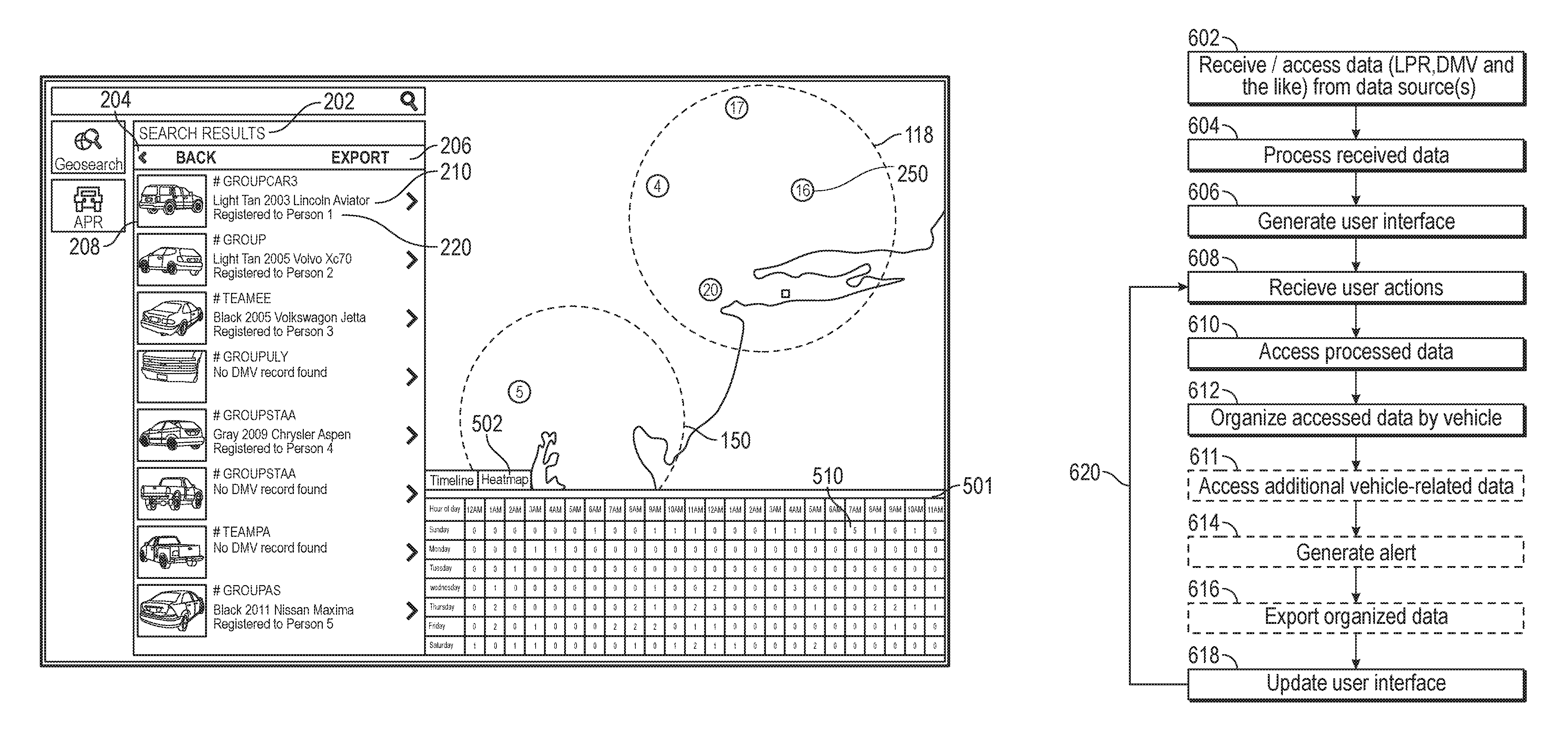
1. A computer system configured to access one or more electronic data sources in response to input from a user provided in an interactive user interface in order to determine vehicle-related data items and interactively update the interactive user interface, the computer system comprising: one or more hardware processors configured to access software instructions causing the computer system to: access search result data including a plurality of vehicle related data items each indicating a day and time that a vehicle was identified within one or more search areas included in a user search query; generate user interface data useable for rendering an interactive user interface, wherein the interactive user interface includes an interactive heatmap and a search result list, wherein the search result list includes a list of one or more vehicles, and wherein the interactive heatmap includes: indications of one or more days of a week along a first axis; indications of one or more time periods within a day along a second axis orthogonal to the first axis; and at each intersection of respective days and time periods, an indication of a quantity of the plurality of vehicle related data items associated with the respective day and time period; transmit the user interface data to an electronic display such that the interactive user interface is displayed on the electronic display; receive a selection from a user of a vehicle from the one or more vehicles of the search result list; access a first set of vehicle related data items associated with the selected vehicle from the plurality of vehicle related data items; and update the interactive heatmap to include only indications of the first set of vehicle related data items.
2. The computer system of claim 1, wherein the user interface further includes a timeline user interface, and wherein the software instructions further cause the computer system to: generate timeline user interface data useable for rendering the timeline user interface including: indications of quantity along a first axis; indications of time periods along the second axis orthogonal to the first axis; indications of quantity of vehicle related data items at respective time periods, each of the indications extending to a corresponding quantity indication on the first axes to indicate respective quantities of vehicles in the respective time period; transmit the timeline user interface data to the electronic display such that the timeline user interface is displayed on the electronic display.
3. The computer system of claim 1, wherein the input from the user includes search criteria comprising at least one of: a geographic area of interest, a time period of interest, at least part of a description of a vehicle, or at least part of an identifier of an owner of a vehicle.
4. The computer system of claim 1, wherein the interactive user interface further includes an interactive map, and wherein the software instructions further cause the computer system to: identify a first grouping of vehicle related data items within a first geographic location within the one or more search areas; identify a second grouping of vehicle related data items within a second geographic location within the one or more search areas; and update the interactive map to indicate the first grouping and the second grouping.
5. The computer system of claim 4, wherein the search result list identifies the plurality of vehicle-related data items, and wherein the one or more electronic data sources include at least one of: a vehicle owner information data source, a vehicle license plate data source, or a license plate recognition data source.
6. The computer system of claim 5, wherein the software instructions further cause the computer system to: receive an interaction from a user via the interactive map indicating an update to the one or more search areas, wherein the updated one or more search areas include at least two geographical areas separated by at least some geographical area that is not part of the one or more search areas; update dynamically the search result data based on the updated one or more search areas to determine an updated plurality of vehicle data items; and update dynamically the search result list and the interactive heatmap based on the updated plurality of vehicle data items.
7. The computer system of claim 5, wherein the software instructions further cause the computer system to: receive an interaction from the user of a selection of one or more vehicles from the search list; access the particular vehicle data items associated with the detected particular vehicle; update the user interface to include, based on the accessed data, for each of the particular vehicle data items associated with the selected vehicle, an indication of an individual associated with the particular vehicle data item; and update the interactive map and the interactive heatmap to indicate the particular vehicle data items associated with the detected particular vehicle.
8. The computer system of claim 7, wherein the software instructions further cause the computer system to: detect selection of an intersection of a particular day and a particular time period; access the particular vehicle data items associated with the detected particular day and time period; update the user interface to include, based on the accessed data, for each of the particular vehicle data items associated with the selected intersection, an indication of an individual associated with the particular vehicle data item; and update the search result list and the interactive map to indicate one or more groupings associated with the selected intersection.
9. The computer system of claim 7, wherein the software instructions further cause the computer system to: detect selection of a column of a particular time period; access the particular vehicle data items associated with the detected particular time period; update the user interface to include, based on the accessed data, for each of the particular vehicle data items associated with the selected column, an indication of an individual associated with the particular vehicle data item; and update the search result list and the interactive map to indicate one or more groupings associated with the selected column.
10. The computer system of claim 4, wherein the software instructions further cause the computer system to: detect selection of one of the first grouping or second grouping; dynamically update the search result data based on the updated time period to determine an updated plurality of vehicle data items; and dynamically update the search result list and the interactive heatmap based on the updated plurality of vehicle data items.
11. The computer system of claim 1, wherein the software instructions further cause the computer system to: receive an input from the user corresponding to dragging a first indication of the indications of one or more time periods towards an adjacent second indication of the indications of one or more time periods, wherein the first indication corresponds to a first time period and the second indication corresponds to a second time period; and update the interactive heatmap by replacing the first indication and the second indication with a third indication corresponding to a third time period that merges the first time period and the second time period.
12. The computer system of claim 1, wherein the plurality of vehicle related data items includes data obtained from an automatic license plate recognition system.
13. The computer system of claim 1, wherein the plurality of vehicle related data items includes data obtained from a camera mounted on a stoplight.
Description
TECHNICAL FIELD
The present disclosure relates to systems and techniques for geographical data integration, analysis, and visualization. More specifically, the present disclosure relates to interactive maps including data objects and vehicle information.
BACKGROUND
Interactive geographical maps, such as web-based mapping service applications and Geographical Information Systems (GIS), are available from a number of providers. Such maps generally comprise satellite images or generic base layers overlaid by roads. Users of such systems may, for example, search for and view locations of a small number of landmarks and/or determine directions from one location to another. In some interactive graphical maps, 3D terrain and/or 3D buildings may be visible in the interface.
SUMMARY
The systems, methods, and devices described herein each have several aspects, no single one of which is solely responsible for its desirable attributes. Without limiting the scope of this disclosure, several non-limiting features will now be discussed briefly.
In various embodiments, an interactive vehicle information map system is disclosed that enables a user to efficiently search through large amounts of vehicle-related data from many disparate sources. In various embodiments, the user may, for example, specify various search criteria including time frames, geographic areas, license plate numbers, vehicle descriptions, and/or owner descriptions. Further, in various embodiments, search results may be organized into particular vehicles. In various embodiments, vehicle-related data may be plotted on an interactive map. Additionally, a user may export search results and/or initiate a search alert.
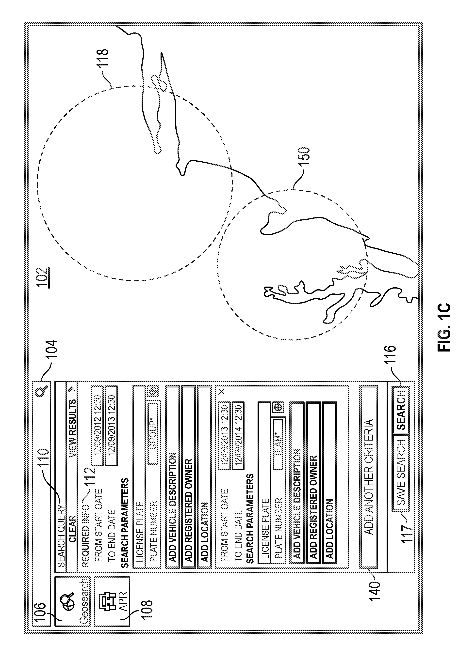
According to an embodiment, a computer system is disclosed. The computer system may comprise: one or more hardware processors configured to cause the computer system to: display an interactive map on an electronic display of the computer system; receive an input from a user of the computing system including search criteria comprising at least one of: a geographic area of interest, a time period of interest, at least part of a description of a vehicle, or at least part of an identifier of an owner of a vehicle; and in response to the input: identify, from one or more electronic data sources, one or more vehicle-related data items that satisfy the search criteria, the one or more electronic data sources including at least one of: a vehicle owner information data source, a vehicle license plate data source, a law enforcement data source, a traffic incident data source, a license-plate recognition data source, or a parking information data source; associate each of the identified vehicle-related data items with one or more corresponding vehicles; and display information regarding one or more of the vehicles having vehicle-related data items associated therewith.
According to another embodiment, another computer system is disclosed. The computer system may comprise: one or more hardware processors configured to cause the computer system to: display an interactive map on an electronic display of the computer system; receive an input from a user of the computing system including vehicle search criteria; identify, from one or more electronic data sources, vehicle-related data satisfying the vehicle search criteria, the vehicle related data including associated metadata; associate the identified vehicle-related data with one or more corresponding vehicles; for each of the vehicles: identify, from the one or more electronic data sources, additional vehicle-related data related to respective vehicles, the additional vehicle-related data identified based on data and metadata previously associated respective vehicles; and associate the additional vehicle-related data with the one or more corresponding vehicles; and display information regarding one or more of the vehicles having vehicle-related data items associated therewith.
According to yet another embodiment, a computer-implemented method is disclosed. The computer-implemented method may comprise: under control of a computing system configured with specific computer executable instructions, displaying an interactive map on an electronic display of the computer system; receiving an input from a user of the computing system including vehicle search criteria; identifying, from one or more electronic data sources, vehicle-related data satisfying the vehicle search criteria, the vehicle related data including associated metadata; associating the identified vehicle-related data with one or more corresponding vehicles; for each of the vehicles: identifying, from the one or more electronic data sources, additional vehicle-related data related to respective vehicles, the additional vehicle-related data identified based on data and metadata previously associated respective vehicles; and associating the additional vehicle-related data with the one or more corresponding vehicles; and displaying information regarding one or more of the vehicles having vehicle-related data items associated therewith.
BRIEF DESCRIPTION OF THE DRAWINGS
The following aspects of the disclosure will become more readily appreciated as the same become better understood by reference to the following detailed description, when taken in conjunction with the accompanying drawings.
FIGS. 1A-1C illustrate sample user interfaces of an interactive vehicle information map system, according to an embodiment of the present disclosure.
FIGS. 2A-2C illustrate sample user interfaces of the interactive vehicle information map system in which a search is performed and results are displayed, according to embodiments of the present disclosure.
FIGS. 3A-3D illustrate sample user interfaces of the interactive vehicle information map system in which detailed vehicle and other information is displayed, according to embodiments of the present disclosure.
FIG. 4 illustrates a sample user interface of the interactive vehicle information map system in which an interactive timeline is displayed, according to embodiments of the present disclosure.
FIG. 5 illustrates a sample user interface of the interactive vehicle information map system in which an interactive heatmap is displayed, according to embodiments of the present disclosure.
FIGS. 6A, 6B, and 7 show flowcharts depicting illustrative operations of the interactive vehicle information map system, according to embodiments of the present disclosure.
FIGS. 8A-8B illustrate a network environment and computer systems and devices with which various methods and systems discussed herein may be implemented, according to various embodiments of the present disclosure.
DETAILED DESCRIPTION
Overview
An interactive vehicle information map system ("map system") is disclosed in which, in various embodiments, large amounts of geographical, geospatial, vehicle, and other types of data, geodata, objects, features, and/or metadata are efficiently presented to a user on an interactive map interface. In various embodiments, the interactive vehicle information map system allows for rapid and deep searching, retrieval, and/or analysis of various vehicle-related data, objects, features, and/or metadata by the user. In an embodiment, the user may search vehicle-related data via the interactive map by providing search criteria including, for example, information regarding a geographic area, a time period, a vehicle, a vehicle owner, and/or a license plate number, among other items. In some embodiments, a search may include multiple separate geographic regions, such that vehicles located within one (or both) of the geographic regions are included in search results. The map system may provide search results including a list of vehicles that match the search criteria, vehicle information, and/or points on the interactive map that indicate license plate recognition read locations, among other information. In an embodiment, the user may view detailed information associated with particular vehicles including, for example, captured images, vehicle-owner data, event history, and the like. In some embodiments, alerts may be configured by a user (or as a system default) to provide vehicle information to a user as updated information matching the user's search query is accessed by the map system.
Definitions
In order to facilitate an understanding of the systems and methods discussed herein, a number of terms are defined below. The terms defined below, as well as other terms used herein, should be construed to include the provided definitions, the ordinary and customary meaning of the terms, and/or any other implied meaning for the respective terms. Thus, the definitions below do not limit the meaning of these terms, but only provide exemplary definitions.
User or individual: a single person or a group of people, such as, for example, married couples or domestic partners, organizations, groups, and business entities. Additionally, the terms may be used interchangeably. In some embodiments, the terms refer to a computing device of a user rather than, or in addition to, one or more actual human operators of the computing device.
Database: A broad term for any data structure or data store for storing and/or organizing data, including, but not limited to, relational databases (Oracle database, MySQL database, etc.), non-relational databases (Elasticsearch, etc.), spreadsheets, XML files, and/or text files, among others.
Data Object, Object, or Feature: A data container for information representing specific things in the world that have a number of definable properties. For example, a data object can represent an entity such as a vehicle, a person, a place, an organization, a market instrument, or other noun. A data object can represent an event that happens at a point in time or for a duration. A data object may be associated with a unique identifier that uniquely identifies the data object. The object's attributes (for example, metadata about the object) may be represented in one or more properties. For the purposes of the present disclosure, the terms "event," "feature," "data object," and "object" may be used interchangeably to refer to items displayed on the map interface of the interactive vehicle information map system, and/or otherwise accessible to the user through the interactive vehicle information map system. Examples of events/objects include, but are not limited to, license-plate reads, traffic incidents (such as accidents), parking information, law enforcement activities (for example, traffic citations), vehicles, persons (for example, vehicle owners), and the like.
Properties: Also referred to as "metadata," includes attributes of a data object/feature. At a minimum, each property/metadata of a data object has a type (such as a property type) and a value or values. Properties/metadata associated with features/objects may include any information relevant to that feature/object. Events/objects may be associated with various other events/objects, metadata and/or properties. For example, a vehicle object may be associated with various vehicle owner information, traffic incidents, license-plate reads, and the like.
Vehicle: A broad term that may, in various embodiments, refer to any of various types of machines including bicycles, automobiles (such as cars and trucks), motorcycles, boats, trains, and/or airplanes, among others.
Vehicle-Related Data: Any type of data and/or information related to a vehicle. Examples may include license plate recognition data, vehicle license plate data, vehicle owner information data, vehicle incident data, parking information data, and the like. Vehicle-related data may be obtained from a single database or multiple databases. The single and/or multiple databases from which vehicle-related data may be obtained may be operated, maintained, and/or owned by various entities. For example, vehicle-related data may be obtained from public entities, private entities, law enforcement entities, government entities (for example, a department of motor vehicles ("DMV")), license plate recognition sources, and the like.
License Plate Recognition ("LPR"): Also referred to as Automatic License Plate Recognition ("ALPR"). Any process or system that uses optical character recognition on images to read vehicle registration plates (for example, vehicle license plates). For example, license plate recognition may be accomplished by capturing a vehicle license plate with a camera mounted on a stoplight, on law enforcement vehicle, on a tow truck, or on any other type of vehicle, and/or near a road. The characters of the license plate may then be determined by optical character recognition to identify the vehicle. An image of the vehicle, an image of the license plate, the determined license plate characters, information related to the identified vehicle, information related to the registered vehicle owner, and/or any other type of information may be stored in one or more databases as part of license plate recognition. The present disclosure may use the terms "license plate recognition event" and/or "license plate recognition read" interchangeably to refer to particular events in which a license plate is read by an LPR process.
Search Query: a set of properties usable to identify particular data objects associated with the properties. Search results are the set of data objects identified as associated with the properties of the search query. A search query may include vehicle-related properties defining characteristics of vehicles that should be included in the corresponding search results. For example, a search query may include a vehicle color, geographic region, and time period. Search results for this example query would include vehicles located in the geographic region during the time period that are the indicated vehicle color. A search query may be executed in real-time as attributes are defined by a user and/or on an ongoing or periodic basis in order to trigger delivery of alerts to the user when new search results are located.
Scene: a combination of a location and time search query attributes. For example, a user may define a scene to include a geographic region define via an interactive map interface and a time period. The map system may then include the scene criteria in the search query (or the scene criteria may be the only attributes of the search query) in identifying any matching vehicles. In some embodiments, multiple scenes may be included in a search query, either in an "and" or "or relationship.
Alert or notification (which may be used interchangeably): information regarding a search query that is provided to a user and/or automatically transmitted to a device operated by the user after the search query has been established. An alert can be transmitted at the time that the alert is identified by the map system or at some determined time after identification of the alert. When received by the user's device, the alert can cause the device to display the alert and/or notification via the activation of an application on the device (e.g., a browser, a mobile application, etc.). For example, receipt of the alert may automatically activate an application on the device, such as a messaging application (e.g., SMS or MMS messaging application), a standalone application (e.g., a vehicle tracking application provided to the user by the map system discussed herein), or a browser, for example, and display information included in the alert. If the device is offline when the alert is transmitted, the application may be automatically activated when the device is online such that the alert is displayed. As another example, receipt of the alert may cause a browser to open and be redirected to a login page generated by the map system so that the user can log in to the map system and view the alert. Alternatively, the alert may include a URL of a webpage (or other online information) associated with the alert, such that when the device (e.g., a mobile device) receives the alert, a browser (or other application) is automatically activated and the URL included in the alert is accessed via the Internet. The alert may be determined based on preferences stored in a data store.
Description of the Figures
Embodiments of the disclosure will now be described with reference to the accompanying figures, wherein like numerals refer to like elements throughout. The terminology used in the description presented herein is not intended to be interpreted in any limited or restrictive manner, simply because it is being utilized in conjunction with a detailed description of certain specific embodiments of the disclosure. Furthermore, embodiments of the disclosure may include several novel features, no single one of which is solely responsible for its desirable attributes or which is essential to practicing the embodiments of the disclosure herein described.
FIG. 1A illustrates a sample user interface of the interactive vehicle information map system, according to an embodiment of the present disclosure. In the example of FIG. 1A, the user interface includes a map interface 102, a search box 104, a geosearch button/icon 106, an Automatic License-Plate Recognition button/icon 108, and a search query box 110. As shown, the search query box 110 includes various required information boxes 112, various search parameters 114, a search button 116, and a save search button 117. Additionally, various events/objects, such as locations of license plate reads of vehicles matching search criteria, may be represented on the map interface 102 with icons and/or symbols, such as icon 115 (which is shown as a small square in the example figures, but could be any other display object, such as a dot, circle, etc., of various sizes, colors, etc.). In various embodiments, functionality of the interactive vehicle information map system (as described in reference to FIG. 1A-1C, and FIGS. 2A-7 below) may be implemented in one or more computer modules and/or processors, as is described below with reference to FIGS. 8A-8B.
The map interface 102 of FIG. 1A is composed of multiple map tiles. The map tiles may be composed of multiple layers of geographical, vector, and/or other types of data. Vector data layers (also referred to as vector layers) may include associated and/or linked data objects/events. Example systems and methods for generating an interactive map interface, such as the map interface 102, may be found in U.S. patent application Ser. No. 13/917,571 (the '571 Application), filed Jun. 13, 2013, and titled "Interactive Geospatial Map," which is hereby incorporated by reference herein in its entirety and for all purposes. Another example systems and methods for generating an interactive map interface may be found in U.S. Pat. No. 9,021,384, issued Apr. 28, 2015, and titled "Interactive Vehicle Information Map," which is hereby incorporated by reference herein its entirety and for all purposes.
In various embodiments, the user interface of FIG. 1A is displayed on an electronic display viewable by a user of the interactive vehicle information map system. The user of the interactive vehicle information map system may interact with the user interface of FIG. 1A by, for example, touching the display when the display is touch-enabled and/or using a mouse pointer to click on the various elements of the user interface.
The map interface 102 may include various highlighted objects. For example, the map interface 102 may include roads, buildings and structures, utilities, lakes, rivers, vegetation, and railroads, among other objects. The user may interact with the map interface 102 by, for example, rolling over and/or clicking on various objects. In one embodiment, rolling over and/or placing the mouse pointer over an object may cause the object to be outlined and/or otherwise highlighted. In the embodiment shown, various license plate recognition events are shown in the map interface 102, each represented by colored or shaded dots (such as icon 115). In this example, the locations of the objects on the map indicate the locations of the license plate recognition events (also referred to as license plate recognition reads).
The user of the map system may interact with the user interface (as shown in FIG. 1A) by scrolling or panning up, down, and/or side to side; zooming in or out; selecting objects; drawing shapes; selecting layers; performing a geosearch; viewing license plate recognition data (for example, the locations of license plate recognition reads and/or locations of license plate recognition cameras); viewing event information (for example, parking information, traffic events, law enforcement events, and the like); and/or viewing registered owner address locations; among other actions as are described below. Various user actions may reveal more or less map detail, and/or more or fewer objects.
In various embodiments, a user may provide various textual queries to the map system via the search box 104. For example, the user may search for a particular geographical location, such as a city, state, and/or zip code. Matching locations may be shown in a dropdown box, which the user may select. Selection of a search result may cause the map interface 102 to move and/or zoom to the selected location. In various embodiments, the user may use the search box 104 to search for various objects that may or may not be displayed on the map interface 102.
In various embodiments, the user may select the ALPR (Automatic License Plate Recognition) button 108 to cause, for example, the map system to display various license plate recognition events on the map interface 102 (for example, icon 115). For example, the user may select the ALPR button 108 and, in response, the map system may display any available license plate recognition events on a currently visible portion of the map shown in the map interface 102. In another embodiment, the ALPR button 108 button may be used to toggle display of license plate recognition events on the map interface 102. In an embodiment, the user may select the ALPR button 108 to reveal the search query box 110.
In various embodiments, the user may select the geosearch button 106 to perform a geosearch and/or to reveal the search query box 110. In various embodiments, the term "geosearch" may refer to searches performed via the map system in which a particular geographic area and/or location of interest is defined. In an embodiment, selection of the geosearch button 106 may cause a user interface to be displayed in which the user may provide an address and/or draw a location on the map interface. For example, the user can draw a dotted circle 118 to indicate an area of interest. The geosearch may also be filtered using various vehicle-related attributes, such as those discussed below.
In various embodiments, the example user interface of FIG. 1A (in addition to the example user interfaces of FIG. 1B-5 described below) may or may not include various of the buttons, icons, and/or other aspects shown. For example, in an embodiment the user interface of FIG. 1A may not include the geosearch button 106 and/or the ALPR button 108. Rather, the user may, for example, directly view and/or access the search query box 110.
The user may use the search query box 110 to perform various searches of vehicle-related data. For example, the user may provide various items of search criteria including, for example, information regarding a geographic area, a time period, a vehicle, a vehicle owner, and/or a license plate number, among other items. In an embodiment, under required information 112, the user may provide a custom time period of interest (including a start and end date/time). By providing a start and end date, the user may limit the search of vehicle-related data to a specific time period of interest. The user may provide the start time and the end time by typing into a textbox in some embodiments. For example, the user may be researching an event that occurred on Mar. 1, 2013, at 3:00 PM. Accordingly, the user may limit the search of vehicle-related data to Mar. 1, 2013, between 2:00 PM and 4:00 PM, so as to limit the search to the most relevant information and/or time period. In some embodiments, the map system can provide the user a calendar format user interface element to select the start time and the end time. For example, the user may type part of the date and a calendar format interface element may pop up. The calendar format interface element may give the use the choice to select a specific start time and a specific end time. In some embodiments, the user interface may further include buttons for shortcuts for a specified time of the start time and the end time. The button may indicate a time period of "last week", "yesterday", "last month", or "last year." The user may select a button to enter a specific time period based on the time when the user is using the map system. In an embodiment, time period information may be required to perform a search via the search query box 110. In another, embodiment, time period information may not be required to perform a search via the search query box 110. As noted above, a search query that is limited by at least one geographic region, time period, and/or other criteria, may be referred to herein as a scene. As discussed further below, the map system allows a user to select multiple scenes and can then updated search results based on the multiples scenes.
Additionally, in various embodiments, the user may provide various search parameters by entering information into text boxes under search parameters 114. For example, the user may provide whole and/or partial information related to any of a license plate number, a vehicle description, a registered owner, and/or a geographical location. Multiple types of information may be provided in the same search, and/or multiple types of information may be provided for each search parameter. For example, the user may provide part of a vehicle description and a geographic location and/or a license plate number. As shown in FIG. 1A, the user has provided part of a license plate number: "GROUP*". In an embodiment, an asterisk ("*") may indicate one or more wildcard characters (in other embodiments, the wildcard operator may be assumed for a search without specific inclusion of a wildcard character). Thus, for example, a search for "GROUP*" may match any license plates beginning with "GROUP", for example, "GROUPA", "GROUPYYY", and the like.
In some embodiments, the user may provide an address by selecting the "ADD LOCATION" button 160. The user may provide an address of interest, a latitude and longitude of interest, and/or other geographic identifier. Further, the user may specify a search radius. The user may also draw a shape to indicate a geographic area of interest on the map interface directly in which to limit a search. In various embodiments, the user may draw various shapes (for example, a circle, an ellipse a rectangle, a polygon, and/or any arbitrary as defined by straight and/or curved edges) on the map to define a geographic area of interest in which to limit a search. For example, the user may draw a dotted circle 118 on the map interface 102. After the user draws the dotted circle 118, the map system can update the user interface to indicate the address of interest and/or a latitude and longitude of interest with a radius associated with the dotted circle 118 on the interactive map. The user can manually increase or decrease the radius of the search area by changing the size of the dotted circle 118. The user can also change the search area by moving the relevant map tiles into the circle 118. For example, after the user draws the search area 118, the user can drag another area of interest into the search area 118 while the search area 118 remains stationary.
Furthermore, in various embodiments the user may provide multiple license plate numbers in "Plate Number" search boxes 132. The user may provide multiple license plate numbers by selecting an "ADD" button 130 and adding another license plate number as illustrated in FIG. 1B. In some embodiments, the user may import or copy multiple license plate numbers from another document, such as excel, PDF, word, or any other suitably formatted document. The user may then paste the multiple license plate numbers into the "PLATE NUMBER" search box 132. The map system can detect the existence of different license plate numbers by detecting the existence of spaces or new paragraphs. For example, if the user copies "GROUP* TEAM* BUNCH*" from a word document and pastes them into the search box 132. The map system may detect there are three different license plate numbers because there are two spaces within the copied license plate numbers. The map system can then separate different license plate numbers into different search boxes as indicated in FIG. 1B. The user may then edit the license plate numbers in the search box 132. The user may also delete a license plate number by selecting the delete button 134.
In some embodiments, the user may add another scene to the search query by selecting "ADD ANOTHER CRITERIA" button 140. The map system can update the user interface to include a new set of user interface elements as shown in FIG. 1C. The user can provide another set of start date and end date. For example, the user may include another time limit for the search: between 12:30 PM on Dec. 9, 2013 to 12:30 PM on Dec. 9, 2014. The user may provide another set of search parameters. For example, the user may provide whole and/or partial information related to any of one or more license plate numbers, a vehicle description, a registered owner, and/or a geographical location. Multiple types of information may be provided in the same search. For example, the user may provide part of a vehicle description and a geographic location and/or a license plate number as discussed above in FIG. 1A. The user may provide more than one license plate number by selecting the "ADD" button or by copying license plate numbers from another document as discussed in FIG. 1B.
In some embodiments, the user may provide more than one search areas by drawing more than one area of interest on the interactive map. In various embodiments, the user may draw various shapes (for example, a circle, an ellipse a rectangle, a polygon, and/or any arbitrary as defined by straight and/or curved edges) on the map to define a geographic area of interest in which to limit a search. For example, the user may provide two search areas by drawing a first dotted circle 118 and a second dotted circle 150 as illustrated in FIG. 1C. The map system may update in the user interface with the indication of the areas of interest associated with the dotted circles 118 and 150.
In an embodiment, the user may select the search button 116 and/or the "VIEW RESULTS" button to perform the specified search. In an embodiment, the user may select the "CLEAR" button to clear the provided search criteria.
In an embodiment, the user may select the save search button 117 to save the search and/or generate a search alert. For example, in an embodiment the user may provide search criteria (as described above), perform a search (by, for example, pressing the search button 116) to verify the results of the search meet the user's needs, and then select the save search button 117. Selection of the save search button 117 may, in an embodiment, save the provided search criteria such that a future search may be easily initiated by the user by, for example, selecting the saved search from a list.
In some embodiments, selection of the save search button 117 may initiate a search alert. A search alert may include a periodic re-running of the specified search (using the provided search criteria) and delivery of search results to the user. In an embodiment, the user may indicate the frequency with which the saved search is to be run. In an embodiment, the user may specify how search results are to be delivered. For example, the user may specify an email address, username, phone number, etc. Alternatively, search alert results may be provided as a pop up window in the user interface of the map system, and/or by any other delivery method. In an embodiment, only new search results may be delivered to the user. For example, the user may initiate a search alert for a particular license plate number, in a particular area, for any time period. Subsequent to the initial search, when any new LPR read of the specified license plate number in the specified area (and/or satisfying other search criteria) is found by the map system, the user may be notified via a search alert.
In an embodiment, the map system may include a user interface through which the user may modify and/or view saved searches, and/or create new saved searches. For example, the user interface of FIG. 1A may including a "Manage Alerts" and/or "Manage Searches" button that may be selected by the user to modify and/or view saved searches, and/or create new saved searches. In another example, selection of the save search button 117 may, in an embodiment, cause a user interface to be provided to the user through which the user may modify and/or view saved searches, and/or create new saved searches. In various embodiments, a "Manage Alerts" user interface may include a listing of various saved searches/alerts of the user. Additionally, the "Manage Alerts" user interface may include a listing of various saved searches/alerts of a team, and or teams, of users with which the user is associated. In an embodiment, the user may select a particular search/alert to view, for example, various criteria/parameters associated with the search/alert, a number (and or listing of) results associated with the search/alert, an email address (or other notification method) associated with the search/alerts, and/or the like. In an example, the user may modify, edit, add to, and/or delete any of the various displayed items of information associated with a search/alert. Further, in an embodiment the user may delete particular searches/alerts and/or create new searches/alerts.
FIGS. 2A-2C illustrate sample user interfaces of the interactive vehicle information map system in which a search (for example, based on the search criteria of FIG. 1A) is performed and results are displayed, according to embodiments of the present disclosure. In reference to FIG. 2A, in response to a search (and/or a geosearch), and/or a list of search results 202 may be shown. In various embodiments, a user may select a back button 204 to return to the search query box (as shown in FIG. 1A) to, for example, modify the search criteria. Additionally, the user may select the export button 206 to export the search results to another format (for example, a printable format). For example, the user may select the export button 206 to export various vehicle-related data associated with the various vehicles listed in the search results box 202. The search results 202 may include results of searching for multiple scenes, for example, such as those vehicles that matched one (or both) of the scene search criteria.
As shown, in an embodiment the search results box 202 may include various vehicles that may be identified by the map system as having vehicle-related data that satisfy the search criteria. For example, in an embodiment the map system may search any available vehicle-related data to identify data satisfying the provided search criteria. Then, the identified vehicle-related data may be analyzed by the map system to determine vehicles with which the data is associated. Next, the determined vehicles may be listed in the search results box 202, including various items of related data. In an embodiment, multiple items of identified vehicle-related data that satisfy the search criteria may be related to the same vehicle. For example, multiple License Plate Recognition events (also referred to as License Plate Recognition reads) for the same vehicle may match the provide scene(s) search criteria. In this example, each of the related License Plate Recognition events, and associated vehicle data, may be aggregated and displayed as a single vehicle in the search results box 202, with a listing of the separate LPR reads available in response to selection of the information regarding the vehicle in search results box 202, for example. This process is further described in reference to FIG. 6A-6B below.
Various vehicles having vehicle-related data meeting the search criteria may be displayed in a list, as shown in FIG. 2A. In various embodiments, each listed vehicle may include, for example, a photo (which, in an embodiment, may be obtained from an LPR or other data source) (for example, photo 208), a license plate number (in text and/or an image of the actual license plate), a description of the vehicle, and/or a description or name of a registered owner and/or other user associated with the vehicle (for example, as indicated by 220). In an embodiment, in response to the user selecting and/or hovering a cursor over one of the listed vehicles, particular objects associated with the vehicle may be highlighted and/or displayed on the map (for example, as described below in reference to FIGS. 3A-3D). In an embodiment, the user may select a particular item of information, for example, "Person 1" (as indicated by 220), to view additional information related to that particular item (for example, various data related to Person 1, as described in reference to FIG. 3D below). In some embodiments, search results may be grouped for display on the map, such as according to proximity of LPRs of the search results with a selected scene. For example, search results may be grouped together as each being within a particular geographic radius of one another and/or associated with LPR read times within a range of one another. Depending on the embodiment, the geographic radius, time ranges, and/or other criteria for determined groups of objects in search results, may be automatically determined by the map system based on the particular search results, defined by a user, and/or based on system defaults.
Vehicle data associated with groups of objects (e.g., objects in search results of a scene) may be aggregated and displayed, such as by indicating a quantity of vehicle objects (or vehicle objects with unique license plate numbers in some embodiments) as a grouping number on the interactive map (and/or elsewhere). In some embodiments, the grouping number may appear in a circle or any other shapes that is sized to indicate the grouping area from which the grouping number was determined. In the example of FIG. 2A, in the selected geographic area 118 there is a grouping indicator 152 showing a grouping area of interest and a grouping number of 20, indicating that the grouping indicator is associated with 20 License Plate Recognition events in the current search results. This process is further described in reference to FIG. 6A-6B below.
In some embodiments, if the user wants to change the search radius or the area of interest, the user may resize the dotted circle 118 to make it cover more or less area. The map system can then update associated vehicle information in the result list 202. The map system may then update the grouping information, such as updating grouping members, quantities of objects in each grouping, etc., based on the new geographic area of interest.
In an embodiment, a save search button, similar to the save search button 117 described above in reference to FIG. 1A, may be included in the search results box 202. For example, a save search button may be included above or below the information associated with the various vehicle search results. In another example, the save search button may be included next to the export button 206. In various embodiments, selecting the save search button causes the map system to save the search and/or generate a search alert (as described above in reference to FIG. 1A) associated with the currently displayed search results. For example, selecting the save search button while viewing the search results of FIG. 2A may cause the map system to save (and/or generate a search alert related to) the search criteria (for example, the search for plate numbers starting with "GROUP") and/or results currently displayed.
Referring to FIG. 2B, in an embodiment the user may select and/or hover a cursor over any of the listed vehicles and/or vehicle photos (as shown at indicator 232) to cause the map system to display an enlarged photo of the vehicle (as shown at 234). In various embodiments, multiple License Plate reads may be available to the map system for displaying photos as shown in FIGS. 2A-2B. In these embodiments, the map system may determine a particular photo to display to the user by default based on image selection rules. For example, the map system may select a photo/image of the vehicle that is within a certain time period and/or having a particular optical character recognition quality. For example, a photo that was taken within a particular time period, for example, within the last year (such that, for example, the photo is not so old that the representation of the vehicle is no longer accurate) may be preferred over older photos. Also, a photo that has a high optical character recognition quality, such as a confidence level that characters in the image are correct, may be preferred over other images with lower optical character recognition qualities. In an embodiment, the map system may also determine that a photo taken in the middle of the day (when the sun is brightest) is preferable to a photo taken, for example, at night. Thus, images may be selected for display based on time of day when taken. In some embodiments, the map system may further determine a quality level of the camera that obtained the photo, and select a photo produced by a higher quality camera. In various embodiments, the user may select any of the listed vehicles to view additional vehicle-related data associated with the selected vehicle, as is described in reference to FIGS. 3A-3D below.
In some embodiments, when the user selects and/or hovers a cursor over any of the listed vehicles and/or vehicle photos (as shown at indicator 232) to cause the map system to display an enlarged photo of the vehicle (as shown at 234), the map system will update the grouping number information on the interactive map to indicate the License Plate Recognition events associated with the selected vehicle. For example, when the user selects the vehicle with a license plate number of "GROUPCAR3," the map system will update the grouping number information within the dotted circles 118 and 150 to reflect the numbers of the License Plate Recognition events only associated with the "GROUPCAR3" vehicle as illustrated in FIG. 2B. When the user selects and/or hovers the cursor over to another listed vehicle and/or vehicle photos, the map system will update the grouping number information on the interactive map to reflect the number of License Plate Recognition events only associated with the later selected vehicle.
Referring to FIG. 2C, in an embodiment the user may select and/or hover a cursor over any grouping area on the interactive map to cause the map system to update vehicle information in the result list 202. As discussed in FIG. 2B, in various embodiments a grouping number may indicate that at the grouping area of interest, a certain amount of License Plate Recognition events are available. By selecting the grouping number or the grouping area, the user may instruct the map system to update the result list to show only vehicles associated to the grouping address or grouping area of interest. For example, when the user selects the grouping 250 in FIG. 2C, the map system may update the search result and list only those vehicles associated with the grouping 250 in the search result list 202. In this example, the map system may update the search result to indicate that only five vehicles meet the search criteria in the grouping area of interest. The grouping are of interest In some embodiments, the user may select more than one grouping in the map interface to cause the update in the search result list 202 by using control, shift, or command button.
FIGS. 3A-3D illustrate sample user interfaces of the interactive vehicle information map system in which detailed vehicle and/or other information is displayed, according to embodiments of the present disclosure.
Referring to FIG. 3A, a vehicle details box 302 is shown. A back button 304 may be selected by the user to return to the list of vehicles (as shown in FIGS. 2A-2B), and an export button 206 may be selected by the user to export vehicle-related data associated with the selected vehicle. In the example FIG. 3A, the vehicle details box 302 also includes three buttons that may be selected by the user to display various vehicle-related data associated with the selected vehicle, including a DMV button 308, a License Plate Recognition button 310, and an event history button 312. FIG. 3A shows the DMV button 308 selected by the user such that vehicle-related data, including vehicle and/or owner information may be displayed as indicated at 314. In some embodiments, the map system may get data from other database. Information 314 may be received, in various embodiments, from a DMV database and/or other government, private, and/or public database. Accordingly, the DMV button 308 may be replaced to indicate the source of the database that the map system is using. Additionally, in an embodiment, objects associated with the selected vehicle are shown in the map interface, as indicated by the dotted circles 118 and 150. Also, grouping number information associated with the selected vehicle is also shown in the map interface.
Referring to FIG. 3B, a vehicle details box is shown in which the user has selected the License Plate Recognition button 310. In this embodiment, selection of the License Plate Recognition button 310 causes display of various License Plate Recognition related information, including a vehicle photo 320, a license plate photo 322, and License Plate Recognition data 324. In an embodiment, the License Plate Recognition related information may include multiple License Plate Recognition reads, however one such read is shown in FIG. 3B for illustrative purposes. In an embodiment, License Plate Recognition data 324 may indicate the time of the License Plate Recognition read and/or the source of the License Plate Recognition read/data. In an embodiment, selecting and/or hovering a cursor over one of the License Plate Recognition related information items may cause an associated event/object in the map interface to be displayed and/or highlighted. For example, selecting and/or hovering a cursor over an event/object may cause the grouping number information in the map interface to be displayed and/or highlighted to indicate where the read happened. Similarly, selecting and/or hovering a cursor over an event/object in the map interface may cause an associated License Plate Recognition item in the vehicle details box to be highlighted. In an embodiment, selecting and/or hovering a cursor over an image in the vehicle details box may cause a more detailed view to be displayed, as shown with image 326. In various embodiments, License Plate Recognition information may be obtained from various private and/or other government and/or public databases.
Referring to FIG. 3C, a vehicle details box is shown in which the user has selected the event history button 312. As shown, in an embodiment selection of the event history button 312 causes display of various event information. The number of events shown in the user interface may correspond to the grouping number in the interactive map. In the example of FIG. 3C, there are four events available and there are four events in the interactive map associated with three groupings in the map (with one grouping including two events). The user may select one of the events listed and more detailed information regarding the event may be retrieved and displayed. For example, if the user selects Event 1, the map interface may show address, date, time, description, and/or other data associated with Event 1. Also, the interactive map may be updated to indicate which grouping (and/or the specific location) where Event 1 happened. For example, the grouping associated with Event 1 may be highlighted such as grouping 330 in FIG. 3C, indicating its association with Event 1. The Event description may include, for example, traffic incidents (such as accidents), parking events, law enforcement activities (for example, traffic citations), and the like. In various embodiments, event history information may be obtained from various private and/or other government and/or public databases.
Referring to FIG. 3D, a person details box is shown in which the user has selected to view information and data related to an individual ("Person 1," as indicated at 350). In an embodiment, the user may view information and data related to a person by selecting, for example, a name of the person displayed in the user interface of the map system (for example, the Person 1 shown at 220 of FIG. 2A). As shown, in an embodiment selection of a person causes display of various information and data related to the person, including for example, law enforcement and parking information 352. Information and data related to a person that may be displayed may include, for example, traffic incidents (such as accidents), parking information, law enforcement activities (for example, traffic citations), property ownership, demographic information, and the like. In various embodiments, the user may select to view various information and data related to, for example, persons, vehicles, events or incidents (for example, traffic events), among other objects and/or items. In various embodiments, information and data related to any of the objects and items mentioned above may include displaying those objects and/or items at particular related locations on the map interface of the map system. Additionally, the map system may update the interactive map to indicate the groupings associated with the person as shown in FIG. 3D. In various embodiments, as described below in reference to FIG. 6A-6B, data and information related to various objects and/or items may be accessed from various databases internal and/or external to the map system, including various private, public, and/or government databases.
In various embodiments, a user of the interactive vehicle information map system may view, in addition to Automatic License Plate Recognition data, various other items of information in the map interface. For example, a user may view locations of events associated with law enforcement activities, traffic incidents (such as parking tickets, moving violations, and the like), parking information (such as in public parking lot, meter information), License Plate Number camera locations, and/or the like (such as emergency calls, and the like). In another example, the user may view locations of registered owner addresses. In various embodiments, the various items of information shown on the map interface (including, for example, License Plate Recognition reads, License Plate Recognition camera locations, parking information, traffic events, law enforcement events, registered owner addresses, and the like) may be indicated by particular icons. For example, a registered owner address may be indicated by a house icon, a traffic event may be indicated by a vehicle icon, and/or an LPR camera location may be indicated by a camera icon. In various embodiments, the user may selectively view, in the map interface, one or more of the items of information mentioned above. Further, the user may view items of information associated with particular selected vehicles, persons, search results, and/or the like. In an embodiment, the map system may display the locations of fixed LPR cameras and/or mobile LPR camera for a given time period, for example.
Referring to FIG. 4, in an embodiment the user may select and/or hover a cursor over the Timeline button 402 to cause the map system to display an interactive timeline 401. In some embodiments, the X axis of the interactive timeline may indicate a time period corresponding to the time period criteria the user provides. For example, when the user provides a search time limit of one year, the X axis of the interactive timeline may divide the one year period into smaller time periods, such as into 12 one-month indicators (e.g., bars) or 6 two-month indicators in the timeline 401. As another example, if the user provides a search time period of one week, the X axis of the interactive timeline may divide the one week into 7 days. When the user provides a search time limit of one month, the X axis of the interactive timeline may divide the one month into four weeks, seven four-day periods, or ten three-day periods. In an embodiment, the user may specify how detailed the user wants the X axis of the interactive timeline to be by making a selection in the interactive timeline. Such selection may be an input in the user interface. In some embodiments, the user may also merge different time periods in the interactive timeline into one time period. The user may also delete certain time periods by right clicking or double clicking. The example in FIG. 4 only shows a search time limit divided into months for illustrative purposes. The Y axis of the interactive timeline may indicate the number of the License Plate reads during the specified time period associated with the vehicles listed in the search result list 202. In the example of FIG. 4, in December 2012 there are three instances of License Plate reads associated with the eight cars listed in the search result list 202. Additionally, the Y axis values in the interactive timeline 401 may correspond to the grouping numbers displayed in the map interface. In the example of FIG. 4, the interactive map indicates that there are 62 instances of License Plate reads meeting the search criteria, e.g., the sum of the grouping numbers 4, 16, 17, 20, and 5. The totals of the indicators (e.g., bars) in timeline 401 over the provided time period also equals 62, divided over the twelve-month period.
As discussed above, the user may select and/or hover a cursor over any grouping on the interactive map to cause the map system to update vehicle information in the result list 202. Additionally, in some embodiments the user may select and/or hover a cursor over any grouping indicator on the interactive map to cause the map system to update the interactive timeline to reflect the number of matching events (e.g., License Plate reads) within the selected grouping.
In some embodiments, the user may select and/or hover a cursor over a column in the interactive timeline to cause the map system to update the grouping number in the map interface. For example, when the user selects grouping 250 (indicating 16 events) in the search area 118 in the map interface, the map system will update the interactive timeline to reflect only the License Plate reads associated with the 16 instances and the search result list 202 will be updated as well. In some embodiments, elements of the timeline 401 are selectable to filter the listed vehicles and information on the map. For example, When the user selects the column 404 in the interactive timeline, the map system will update the map interface to reflect only the groupings associated with the time period represented by column 404. Additionally, selection of column 404 may cause the search result list to updated to indicate only the events associated with that time period.
In some embodiments, when the user selects a vehicle in the listed search result in the search result list 202, the map system will update the map interface and the interactive timeline to reflect only the events associated with the selected vehicle. The user may select more than one grouping in the map interface to cause the update in the interactive timeline and the search result list 202. The user may also select more than one column in the interactive timeline to cause updates in the map interface and the search result list 202. The user may also select more than one vehicle in the search result list 202 to cause the updates in the map interface and the interactive timeline.
Referring to FIG. 5, in an embodiment the user may select and/or hover a cursor over the Timeline button 502 to cause to cause the map system to display an interactive heatmap 501. The interactive heatmap may display specific hour and day of the week associated with the events matching the search criteria (or filtered subset, such as a selected scene or grouping). In an embodiment, the interactive heatmap can sort the License Plate reads into hourly groupings associated with respective days of the week. For example, the heatmap may have a Y axis indicating the different days of the week: Sunday, Monday, Tuesday, Wednesday, Thursday, Friday and Saturday. The heatmap may have an X axis that divides the days into 24 hours. The map system may first organize all the License Plate events that happened on Mondays. It may then organize the Monday License Plate events by hours. The heatmap 501 includes, at each intersection of day and hour, a number of events associated with that hour and day over the entire time period of the search query. For example, indicator 510 indicates that five License Plate reads happened during 7 PM to 8 PM on all the Mondays during the search time limit.
In an embodiment, the interactive heatmap may include shading, highlighting, and/or other visual indicator of the absolute (or relative to the other time periods) number of events associated with the corresponding time period. For example, the higher the number, the darker the intersection is highlighted, where darker highlighting indicates that during that specific hour of the week there are more License Plate reads than the lighter highlighted intersections. Additionally, in some embodiments, the user may combine time periods in the heatmap 501, such as by merge two hour indicators of the heatmap 501. Such combinations may be implemented by dragging one time period into another. For example, the user may drag the 3 PM column into the 4 PM column and the interactive heatmap will update to merge the two columns into one 3 PM to 5 PM column. The user may also delete a certain hour by right clicking or double clicking the hour number.
As discussed above, the user may select and/or hover a cursor over any search areas (e.g., search areas 118 or 150) and/or grouping (e.g., the four numbered circles within search area 118) on the interactive map to cause the map system to update vehicle information in the result list 202. For example, the user may select and/or hover a cursor over any grouping area on the map interface to cause the map system to update the interactive heatmap to reflect the number of events within the selected grouping area. Also, the user may select and/or hover a cursor over an intersection in the interactive heatmap to cause the map system to update the grouping numbers in the map interface. For example, when the user selects the grouping 250 (indicating a grouping of 16 events) in the search area 118 in the map interface, the map system will update the interactive heatmap to reflect only the License Plate reads associated with the 16 instances and the search result list 202 will be updated as well. When the user selects the intersection 510 in the interactive heatmap, the map system will update the map interface to reflect only the groupings having events that are part of the selected time period. Additionally, when the user selects a vehicle in the listed search result in the search result list 202, the map system will update the map interface and the interactive heatmap to reflect only the License Pate reads associated with the selected vehicle. The user may select more than one grouping in the map interface to cause updates in the interactive heatmap and the search result list 202. The user may also select more than one intersection in the interactive heatmap to cause updates in the map interface and the search result list 202. The user may also select more than one vehicle in the search result list 202 to cause the updates in the map interface and the interactive heatmap.
Example Operations
FIG. 6A shows a flowchart depicting illustrative operations and/or processes of the interactive vehicle information map system, according to an embodiment of the present disclosure. In various embodiments, fewer blocks or additional blocks may be included in the processes, or various blocks may be performed in an order different from that shown in FIG. 6A. In an embodiment, one or more blocks in FIG. 6A may be performed by, or implemented in, one or more computer modules and/or processors, as is described below with reference to FIGS. 8A-8B.
At block 602, various vehicle-related data may be received and/or accessed by the map system from various databases and/or data sources (including, for example, from databases maintained by private entities, law enforcement entities, government entities (for example, a department of motor vehicles ("DMV")), LPR sources, and the like. In an embodiment, the vehicle-related data may be received at a server-side component of the map system, such as the application server 858 of FIG. 8A. The data may then be processed by the server at block 604. For example, the vehicle-related data may be organized by location, time, type, and/or by any other useful index so as to enable fast searching of the data. At block 606, a user interface is generated that displays a user interface, as described with reference to the figures above. For example, a map interface and various search options may be displayed on the user interface.
At block 608, the user may interact with the user interface of the map system in any of the ways described above, and as further described below in reference to FIG. 7. For example, the user may provide various search criteria to the map system. The user may provide more than one set of search criteria to the map system. At block 610, the processed vehicle-related data may be accessed by the map system based on the provided search criteria, and data satisfying the provided search criteria may be determined and/or identified.
In various embodiments, the map system may access various internal and/or external databases in response to user actions. The various accessed internal and/or external databases may or may not include the processed vehicle-related data described above. For example, in response to a user request for information related to a particular person, the map system may access an external public or private parking database for parking information related to the particular person. In various embodiments, the map system may "iteratively search" for data and information in response to a user action, for example, a search and/or selection of a particular vehicle and/or person. For example, in an embodiment, in response to an initial search for a particular license plate, the map system may, in a first iteration, access DMV data to determine information related to the particular license plate (for example, a registered owner name and address, and a vehicle description and vehicle identification number). Then, the map system may perform a second search iteration in which the obtained DMV data is used to access related data and information in a parking information and/or law enforcement database (for example, to obtain citation information related to the determined vehicle and/or parking information related to the determined vehicle owner). Further, the map system may, in a third iteration, access additional databases (including previously accessed databases) to determine various other items of information related to data obtained in the second (and/or first) iteration. For example, the map system may access property ownership records related to a parking instance determined to be related to the vehicle owner. In various embodiments, data and information accessed in various "iterative" searches may include data objects. In an embodiment, the data and information accessed during interactive searches may be clustered. Examples of data clustering may be found in, for example, U.S. patent application Ser. No. 13/968,265, filed Aug. 15, 2013, titled "GENERATING DATA CLUSTERS WITH CUSTOMIZABLE ANALYSIS STRATEGIES," and U.S. patent application Ser. No. 13/968,213, filed Aug. 15, 2013, titled "PRIORITIZING DATA CLUSTERS WITH CUSTOMIZABLE SCORING STRATEGIES," each of which is hereby incorporated by reference herein in its entirety and for all purposes.
At block 612, the identified vehicle-related data satisfying the one or more set of search criteria is organized into, and/or associated with, one or more vehicles. For example, two LPR reads may have been identified that meet the search criteria and include information related to a same or similar vehicle. For example, each of the LPR reads may indicate a license plate number of XRZ456. In another example, the two LPR reads may have similar license plate numbers, but they may differ slightly due to errors in optical character recognition (for example, one may indicate XRZ456, while the other may indicate XRZ458). In this example, other information related to the License Plate reads, such as identified vehicle color, or determined owner information, may provide sufficient information to the map system that the License Plate reads may be associated with the same vehicle.
Once the vehicle-related data is organized by vehicle, at block 611 the map system may optionally access additional vehicle-related data from other sources that is determined to be related to the identified vehicles. For example, DMV information may indicate an owner and vehicle description associated with the vehicle with license plate XRZ456. Further, parking information data may indicate various events related to either the indicated owner and/or the vehicle with license plate XRZ456. Any such additional data may be accessed, aggregated, and associated with the identified vehicle such that it may be made available to the user of the map system.
At optional block 614 a search alert may be generated by the map system in response to the user selection (as described above). At optional block 616, the organized vehicle data may be exported in response to a user selection (as described above). At block 618, the user interface may be updated in response to the operator's actions. For example, search results may be displayed, vehicle detailed information may be displayed; objects may be displayed on a map interface, among other interface updates described above.
In various embodiments, vehicle-related data may be received and processed by the map system at any time and/or continuously. In an embodiment, vehicle-related data may be updated even as the user is viewing the data on the user interface. For example, in an embodiment, the user may use the map system to analyze substantially real-time vehicle-related data. Additionally, if the user wants another has finished the first search, the user can make another search. The map system can loop back to block 608 through the loop process 620.
FIG. 6B includes additional steps of the operations and/or processes of block 630 of the interactive vehicle information map system in additional to FIG. 6A, according to an embodiment of the present disclosure. At block 618, after the map system updates the user interface, at block 632 the user may further interact with the user interface of the map system. The user may want to view an interactive timeline or an interactive heatmap. After the map system receives the user's instruction to view an interactive timeline or an interactive heatmap, the map system may further group the organized data from block 612 based on the hour of a day, the day of a week, the week of a month, and/or the month of a year at block 633. The map system may then update the user interface based on the actions of the user at block 634. For example, if the user wants to view a timeline, the map system can generate an interactive timeline to reflect a monthly timeline as illustrated in FIG. 4. If the user wants to view a heatmap, the map system can generate an interactive heatmap as illustrated in FIG. 5. Once the user has viewed the timeline or the heatmap, the user can make further interactions with the map system and the map system may update according to the user's actions through a loop process 650. Similarly, if the user wants another has finished the first search, the user can make another search. The map system can loop back to block 608 through the loop process 620.
FIG. 7 shows a flowchart depicting additional illustrative operations and/or processes of the interactive vehicle information map system, according to embodiments of the present disclosure. In various embodiments, fewer blocks or additional blocks may be included in the process, or various blocks may be performed in an order different from that shown in FIG. 7. In an embodiment, one or more blocks in FIG. 7 may be performed by, or implemented in, one or more computer modules and/or processors, as is described below with reference to FIGS. 8A-8B.
At block 702, the user interface is provided to the user, and at block 704 an input from the user is received as described above in reference to FIG. 6A-6B. Examples of inputs received from the user may include, for example, an object selection (706), an object detail request (708), and/or a geosearch (710), among others. Further, the geosearch (710) may include various search criteria provided by the user including a time period (710a), a geographic location or area (710b), license plate information (710c), vehicle information (710d), and/or owner information (710e), among others. In an embodiment of the present disclosure, the user may input more than one object selection (706), more than one object detail request (708), and/or more than one geosearch (710), among others.
In an embodiment, the user inputs may be provided at client-side devices of the map system, such as computing device(s) 852 of FIG. 8A. At block 716, the user inputs may result in queries (such as search queries) to server-side devices of the map system, such as application server 858 of FIG. 8A. The queries may be in response to any of inputs 706, 708, and/or 710 from the user. In various embodiments, the server-side components then update and re-compose map tiles of the map interface, and provide vehicle-related data, in accordance with the user input, and transmits the updates back to the client-side components. Examples of processes for updating map tiles may be found in the '571 Application.
At block 718, the client-side components receive the updated map tile and vehicle information from the server, and at block 720 the user interface is updated with the received information. At block 722, after the user interface is updated, the user can further interact with the user interface to request to view an interactive timeline and/or an interactive heatmap. At block 724, the user request may result in queries to the server with regard to the accessed tile and vehicle information from block 718. In various embodiments, the sever-side components then update and generate an interactive timeline and/or an interactive heatmap at block 726.
In an embodiment, additional information and/or data, in addition to updated map tiles, may be transmitted to the client-side components from the server-side components. For example, object metadata may be transmitted in response to a user selecting an object.
In an embodiment, one or more blocks in FIG. 7 may be performed by client-side components of the map system, for example, computing device(s) 852.
Advantageously, in various embodiments the interactive vehicle information map system enables a user to efficiently search through large amounts of vehicle-related data from many disparate sources. The user may, for example, specify various search criteria including time frames, geographic areas, license plate numbers, vehicle descriptions, and/or owner descriptions. Further, search results may be organized into particular vehicles. In various embodiments, vehicle-related data may be plotted on an interactive map. Additionally, a user may export search results and/or initiate a search alert.
Implementation Mechanisms
FIG. 8A illustrates a network environment in which the interactive vehicle information map system may operate, according to embodiments of the present disclosure. The network environment 850 may include one or more computing devices 852, a network 856, an application server 858, and one or more data sources 860. The constituents of the network environment 850 may be in communication with each other either locally or over the network 856.
In an embodiment, the computing device(s) 852 may be any computing devices capable of displaying software applications to a user and receiving input from the user. For example, the computing device(s) 852 may include smartphones, tablets, laptops, and/or other types of computing devices. The computing device(s) 852 may also be capable of communicating over the network 856, for example, to request data from, and/or to data to, the application server 858.
In some embodiments, the computing device(s) 852 may include non-transitory computer-readable medium storage for storing vehicle-related data and/or other map application data. For example, computing device(s) 852 may include one or more software modules 854 that may implement aspects of the functionality of the interactive vehicle information map system. The software module(s) 854 may be configured to present the map application to a user and receive interactions from the user. Additional aspects, operations, and/or functionality of computing device(s) 852 are described in further detail in reference to FIG. 8B below.
The network 856 may be any wired network, wireless network, or combination thereof. In addition, the network 856 may be a personal area network, local area network, wide area network, cable network, satellite network, cellular telephone network, or combination thereof. Protocols and components for communicating via the Internet or any of the other aforementioned types of communication networks are well known to those skilled in the art of computer communications and thus, need not be described in more detail herein.
The application server 858 is a computing device, similar to the computing devices described above, that may perform a variety of tasks to implement the operations of the interactive vehicle information map system. The interaction server may include one or more software modules 870 that may be configured to, for example, receive vehicle-related data, process vehicle-related data, generate map tiles, process inputs from the user, and/or update the user interface. Additional aspects, operations, and/or functionality of application server 858 are described in further detail in referenced to FIG. 8B below.
The application server 858 may be in communication with data source(s) 860. The data source(s) 860 may include, for example, parking information data sources, DMV data sources, LPR data sources, and/or other public, private, and/or government data sources. One or more of the data source(s) 860 may include electronic storage local to the application server 858. The data source(s) 860 may be embodied in hard disk drives, solid state memories, and/or any other type of non-transitory, computer-readable storage medium remotely or locally accessible to the application server 858. The data source(s) 860 may also be distributed or partitioned across multiple storage devices as is known in the art without departing from the spirit and scope of the present disclosure.
In various embodiments, the map system may be accessible by the user through a web-based viewer, such as a web browser. In this embodiment, the user interface may be generated by the application server 858 and transmitted to the web browser of the user. Alternatively, data necessary for generating the user interface may be provided by the application server 858 to the browser, where the user interface may be generated. The user may then interact with the user interface through the web-browser. In an embodiment, the user interface of the interactive vehicle information map system may be accessible through a dedicated software application. In an embodiment, the user interface of the interactive vehicle information map system may be accessible through a mobile computing device, such as a smartphone and/or tablet. In this embodiment, the application server 858 may generate and transmit a user interface to the mobile computing device. Alternatively, the mobile computing device may include modules for generating the user interface, and the application server 858 may provide user interaction data to the mobile computing device. In an embodiment, the application server 858 comprises a mobile computing device.
According to various embodiments, the interactive vehicle information map system and other methods and techniques described herein are implemented by one or more special-purpose computing devices. The special-purpose computing devices may be hard-wired to perform the techniques, or may include digital electronic devices such as one or more application-specific integrated circuits (ASICs) or field programmable gate arrays (FPGAs) that are persistently programmed to perform the techniques, or may include one or more general purpose hardware processors programmed to perform the techniques pursuant to program instructions in firmware, memory, other storage, or a combination. Such special-purpose computing devices may also combine custom hard-wired logic, ASICs, or FPGAs with custom programming to accomplish the techniques. The special-purpose computing devices may be desktop computer systems, server computer systems, portable computer systems, handheld devices, networking devices or any other device or combination of devices that incorporate hard-wired and/or program logic to implement the techniques.
Computing device(s) are generally controlled and coordinated by operating system software, such as iOS, Android, Chrome OS, Windows XP, Windows Vista, Windows 7, Windows 8, Windows Server, Windows CE, Unix, Linux, SunOS, Solaris, iOS, Blackberry OS, VxWorks, or other compatible operating systems. In other embodiments, the computing device may be controlled by a proprietary operating system. Conventional operating systems control and schedule computer processes for execution, perform memory management, provide file system, networking, I/O services, and provide a user interface functionality, such as a graphical user interface ("GUI"), among other things.
For example, FIG. 8B is a block diagram that illustrates a computer system 800 upon which the various systems, devices, and/or methods discussed herein may be implemented. For example, some or all aspects of computing system 800 may be included in any of computing device(s) 852 and/or application server 858. In an embodiment, each of the computing device(s) 852 and application server 858 is comprised of a computing system similar to the computer system 800 of FIG. 8B. Computer system 800 includes a bus 802 or other communication mechanism for communicating information, and a hardware processor, or multiple processors, 804 coupled with bus 802 for processing information. Hardware processor(s) 804 may be, for example, one or more general purpose microprocessors.
Computer system 800 also includes a main memory 806, such as a random access memory (RAM), cache and/or other dynamic storage devices, coupled to bus 802 for storing information and instructions to be executed by processor 804. Main memory 806 also may be used for storing temporary variables or other intermediate information during execution of instructions to be executed by processor 804. Such instructions, when stored in storage media accessible to processor 804, render computer system 800 into a special-purpose machine that is customized to perform the operations specified in the instructions.
Computer system 800 further includes a read only memory (ROM) 808 or other static storage device coupled to bus 802 for storing static information and instructions for processor 804. A storage device 810, such as a magnetic disk, optical disk, or USB thumb drive (Flash drive), etc., is provided and coupled to bus 802 for storing information and instructions.
Computer system 800 may be coupled via bus 802 to a display 812, such as a cathode ray tube (CRT), LCD display, or touch screen display, for displaying information to a computer user and/or receiving input from the user or operator. An input device 814, including alphanumeric and other keys, is coupled to bus 802 for communicating information and command selections to processor 804. Another type of user input device is cursor control 816, such as a mouse, a trackball, or cursor direction keys for communicating direction information and command selections to processor 804 and for controlling cursor movement on display 812. This input device typically has two degrees of freedom in two axes, a first axis (e.g., x) and a second axis (e.g., y), that allows the device to specify positions in a plane. In some embodiments, the same direction information and command selections as cursor control may be implemented via receiving touches on a touch screen without a cursor.
Computing system 800 may include modules configured to generate a user interface, map interface, and/or the various other aspects of the interactive vehicle information map system. These modules may include, for example, software module(s) 854 and/or software module(s) 870 described above, among others. The modules may be stored in a mass storage device as executable software codes that are executed by the computing device(s). This and other modules may include, by way of example, components, such as software components, object-oriented software components, class components and task components, processes, functions, attributes, procedures, subroutines, segments of program code, drivers, firmware, microcode, circuitry, data, databases, data structures, tables, arrays, and variables.
In general, the word "module," as used herein, refers to logic embodied in hardware or firmware, or to a collection of software instructions, possibly having entry and exit points, written in a programming language, such as, for example, Java, Lua, C or C++. A software module may be compiled and linked into an executable program, installed in a dynamic link library, or may be written in an interpreted programming language such as, for example, BASIC, Perl, or Python. It will be appreciated that software modules may be callable from other modules or from themselves, and/or may be invoked in response to detected events or interrupts. Software modules configured for execution on computing devices may be provided on a computer readable medium, such as a compact disc, digital video disc, flash drive, magnetic disc, or any other tangible medium, or as a digital download (and may be originally stored in a compressed or installable format that requires installation, decompression or decryption prior to execution). Such software code may be stored, partially or fully, on a memory device of the executing computing device, for execution by the computing device. Software instructions may be embedded in firmware, such as an EPROM. It will be further appreciated that hardware modules may be comprised of connected logic units, such as gates and flip-flops, and/or may be comprised of programmable units, such as programmable gate arrays or processors. The modules or computing device functionality described herein are preferably implemented as software modules, but may be represented in hardware or firmware. Generally, the modules described herein refer to logical modules that may be combined with other modules or divided into sub-modules despite their physical organization or storage
Computer system 800 may implement the techniques described herein using customized hard-wired logic, one or more ASICs or FPGAs, firmware and/or program logic which in combination with the computer system causes or programs computer system 800 to be a special-purpose machine. According to one embodiment, the techniques herein are performed by computer system 800 in response to processor(s) 804 executing one or more sequences of one or more modules and/or instructions contained in main memory 806. Such instructions may be read into main memory 806 from another storage medium, such as storage device 810. Execution of the sequences of instructions contained in main memory 806 causes processor(s) 804 to perform the process steps described herein. In alternative embodiments, hard-wired circuitry may be used in place of or in combination with software instructions.
The term "non-transitory media," and similar terms, as used herein refers to any media that store data and/or instructions that cause a machine to operate in a specific fashion. Such non-transitory media may comprise non-volatile media and/or volatile media. Non-volatile media includes, for example, optical or magnetic disks, such as storage device 810. Volatile media includes dynamic memory, such as main memory 806. Common forms of non-transitory media include, for example, a floppy disk, a flexible disk, hard disk, solid state drive, magnetic tape, or any other magnetic data storage medium, a CD-ROM, any other optical data storage medium, any physical medium with patterns of holes, a RAM, a PROM, and EPROM, a FLASH-EPROM, NVRAM, any other memory chip or cartridge, and networked versions of the same.
Non-transitory media is distinct from but may be used in conjunction with transmission media. Transmission media participates in transferring information between nontransitory media. For example, transmission media includes coaxial cables, copper wire and fiber optics, including the wires that comprise bus 802. Transmission media can also take the form of acoustic or light waves, such as those generated during radio-wave and infra-red data communications.
Various forms of media may be involved in carrying one or more sequences of one or more instructions to processor 804 for execution. For example, the instructions may initially be carried on a magnetic disk or solid state drive of a remote computer. The remote computer can load the instructions and/or modules into its dynamic memory and send the instructions over a telephone line using a modem. A modem local to computer system 800 can receive the data on the telephone line and use an infra-red transmitter to convert the data to an infra-red signal. An infra-red detector can receive the data carried in the infra-red signal and appropriate circuitry can place the data on bus 802. Bus 802 carries the data to main memory 806, from which processor 804 retrieves and executes the instructions. The instructions received by main memory 806 may optionally be stored on storage device 810 either before or after execution by processor 804.
Computer system 800 also includes a communication interface 818 coupled to bus 802. Communication interface 818 provides a two-way data communication coupling to a network link 820 that may be connected to any other interface and/or network, for example network 856 of FIG. 8A. For example, communication interface 818 may be an integrated services digital network (ISDN) card, cable modem, satellite modem, or a modem to provide a data communication connection to a corresponding type of telephone line. As another example, communication interface 818 may be a local area network (LAN) card to provide a data communication connection to a compatible LAN (or WAN component to communicate with a WAN). Wireless links may also be implemented. In any such implementation, communication interface 818 sends and receives electrical, electromagnetic or optical signals that carry digital data streams representing various types of information.
Network link 820 typically provides data communication through one or more networks to other data devices. For example, network link 820 may provide a connection through one or more local or non-local networks to host computers or other data equipment operated by an Internet Service Provider (ISP).
In an embodiment, the network link 820 may provide data communication services through the world wide packet data communication network now commonly referred to as the "Internet." Communication may be accomplished through the user of, for example, electrical, electromagnetic, and/or optical signals that carry digital data streams. The signals through the various networks and the signals on network link 820 and through communication interface 818, which carry the digital data to and from computer system 800, are example forms of transmission media.
Computer system 800 may send messages and/or receive data, including program code, through the network(s), network link 820 and communication interface 818. In the Internet example, a server or other computer-enabled device or system may transmit a requested code for an application program through one or more networks and/or communication interface 818.
Each of the processes, methods, and algorithms described in the preceding sections may be embodied in, and fully or partially automated by, code modules executed by one or more computer systems or computer processors comprising computer hardware. The processes and algorithms may be implemented partially or wholly in application-specific circuitry.
The various features and processes described above may be used independently of one another, or may be combined in various ways. All possible combinations and subcombinations are intended to fall within the scope of this disclosure. In addition, certain method or process blocks may be omitted in some implementations. The methods and processes described herein are also not limited to any particular sequence, and the blocks or states relating thereto can be performed in other sequences that are appropriate. For example, described blocks or states may be performed in an order other than that specifically disclosed, or multiple blocks or states may be combined in a single block or state. The example blocks or states may be performed in serial, in parallel, or in some other manner. Blocks or states may be added to or removed from the disclosed example embodiments. The example systems and components described herein may be configured differently than described. For example, elements may be added to, removed from, or rearranged compared to the disclosed example embodiments.
Conditional language, such as, among others, "can," "could," "might," or "may," unless specifically stated otherwise, or otherwise understood within the context as used, is generally intended to convey that certain embodiments include, while other embodiments do not include, certain features, elements and/or steps. Thus, such conditional language is not generally intended to imply that features, elements and/or steps are in any way required for one or more embodiments or that one or more embodiments necessarily include logic for deciding, with or without user input or prompting, whether these features, elements and/or steps are included or are to be performed in any particular embodiment.
The term "comprising" as used herein should be given an inclusive rather than exclusive interpretation. For example, a general purpose computer comprising one or more processors should not be interpreted as excluding other computer components, and may possibly include such components as memory, input/output devices, and/or network interfaces, among others.
Any process descriptions, elements, or blocks in the flow diagrams described herein and/or depicted in the attached figures should be understood as potentially representing modules, segments, or portions of code which include one or more executable instructions for implementing specific logical functions or steps in the process. Alternate implementations are included within the scope of the embodiments described herein in which elements or functions may be deleted, executed out of order from that shown or discussed, including substantially concurrently or in reverse order, depending on the functionality involved, as would be understood by those skilled in the art.
It should be emphasized that many variations and modifications may be made to the above-described embodiments, the elements of which are to be understood as being among other acceptable examples. All such modifications and variations are intended to be included herein within the scope of this disclosure. The foregoing description details certain embodiments of the invention. It will be appreciated, however, that no matter how detailed the foregoing appears in text, the invention can be practiced in many ways. As is also stated above, it should be noted that the use of particular terminology when describing certain features or aspects of the invention should not be taken to imply that the terminology is being re-defined herein to be restricted to including any specific characteristics of the features or aspects of the invention with which that terminology is associated. The scope of the invention should therefore be construed in accordance with the appended claims and any equivalents thereof.
* * * * *
References
-
golemxiv.co.uk/2012/08/a-word-about-banks-and-the-laundering-of-drug-money
-
amnetblog.com/component/content/article/115-5-grate-tools-for-visualizing-your-twitter-followers.html
-
java.sun.com/developer/technicalArticles/J2SE/Desktop/javase6/modality/Jan
-
docs.google.com/document/d/1cTmxg7mVx5gd89lqblCYvCEnHA4QAivH4l4WpyPsqE4/edit?pli=1
-
capdtron.files.wordpress.com/2013/01/outlook-2010-inside_out.pdf
-
bugzilla.mozilla.org/show_bug.cgi?id=18726
-
w3.org/TR/2012/WD-css3-ui-20120117/#resizing-amp-overflow
-
directionsmag.com/articles/retail-trade-area-analysis-using-the-huff-mode1/123411
-
gis.planning.lacounty.gov/GIS-NET3_Public/Viewer.html
-
azavea.com/blogs/newsletter/v4i4/kernel-density-capabilities-added-to-hunchlab
-
keylines.com/wp-content/uploads/2014/03/KeyLines-White-Paper.pdf
-
-
-
www-users.cs.umn.edu/.about.npramod/enc_pdf.pdf
-
mozilla.org/editor/ui_specs/FileSaveDialogs.html
-
mapbuilder.net
-
maps.yahoo.com
-
maps.bing.com
-
maps.google.com
-
msdn.microsoft.com/en-us/library/ff604039%28v=office.14%29.aspx
-
office.microsoft.com/en-us/visio-help/about-connecting-shapes-HP085050369.aspx
-
-
docs.oracle.com/cd/B28359_01/appdev.111/b28400.pdf
-
techcrunch.com/2013/05/15/deep-dive-with-the-new-google-maps-for-desktop-with-google-earth-integration-its-more-than-just-a-utility
-
openstreetmap.org/user/amm/diary
-
poieditor.com/articles/how_to_create_your_own_points_of_interest
-
finsolinc.com/ANTI-MONEY%20LAUNDERING%20TRAINING%20GUIDES.pdf
-
utsa.edu/lrsg/Teaching/EES6513/08-3D.pdf
-
pdf.aminer.org/000/648/038/under_the_hood_of_geovrml.pdf
-
stackoverflow.com/questions/17964681/refresh-css-ellipsis-when-resizing-container
-
searchdatamanagement.techtarget.com/definition/OLAP-cube
-
sonris-dnr.state.la.us/gis/instruct_files/tutslide12
-
vbforums.com/showthread.php?198436-Buffer-a-Polygon
-
vividsolutions.com/jts/bin/JTS%20Technical%20Specs.pdf
-
de.wikipedia.org/w/index.php?title=Douglas-Peucker-Algorithmus&oldid=91846042
-
en.wikipedia.org/w/index.php?title=Federated_database_system&oldid=571954221
-
-
lists.osgeo.org/pipermail/geos-devel/2011-May/005210.html
D00000
D00001
D00002
D00003
D00004
D00005
D00006
D00007
D00008
D00009
D00010
D00011
D00012
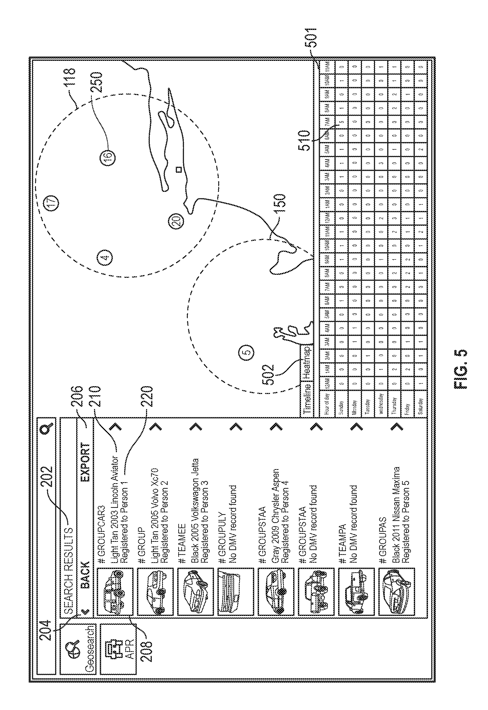
D00013

D00014
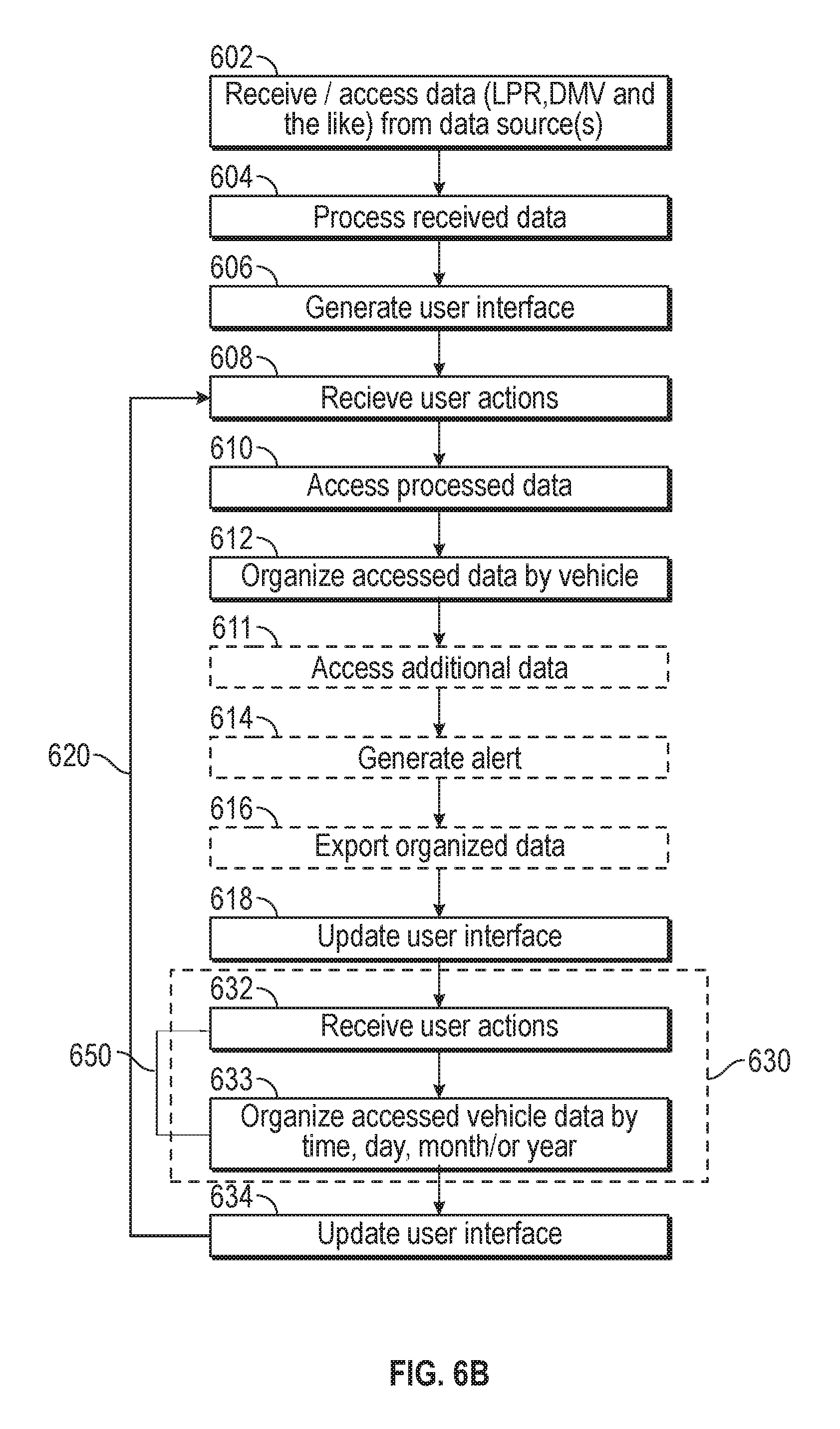
D00015

D00016
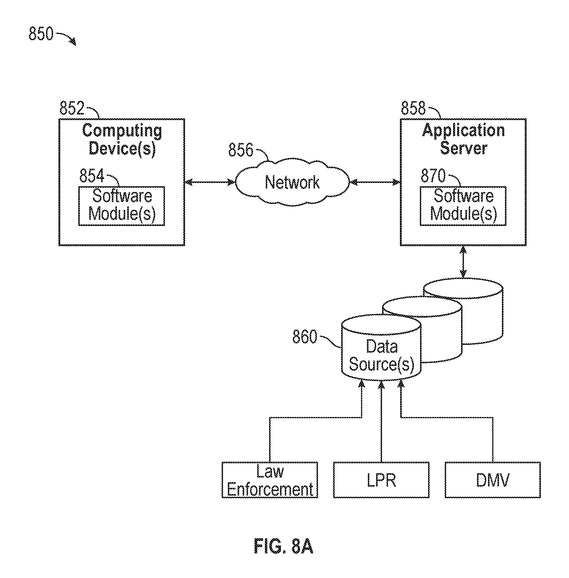
D00017

XML
uspto.report is an independent third-party trademark research tool that is not affiliated, endorsed, or sponsored by the United States Patent and Trademark Office (USPTO) or any other governmental organization. The information provided by uspto.report is based on publicly available data at the time of writing and is intended for informational purposes only.
While we strive to provide accurate and up-to-date information, we do not guarantee the accuracy, completeness, reliability, or suitability of the information displayed on this site. The use of this site is at your own risk. Any reliance you place on such information is therefore strictly at your own risk.
All official trademark data, including owner information, should be verified by visiting the official USPTO website at www.uspto.gov. This site is not intended to replace professional legal advice and should not be used as a substitute for consulting with a legal professional who is knowledgeable about trademark law.