Satellite communications networking
Baudoin , et al.
U.S. patent number 10,361,774 [Application Number 15/727,170] was granted by the patent office on 2019-07-23 for satellite communications networking. This patent grant is currently assigned to IRIDIUM SATELLITE LLC. The grantee listed for this patent is IRIDIUM SATELLITE LLC. Invention is credited to Cedric Baudoin, Jean-Francois Boutillon.


| United States Patent | 10,361,774 |
| Baudoin , et al. | July 23, 2019 |
Satellite communications networking
Abstract
A method of operating a satellite communication network is disclosed. The network includes a plurality of satellites interconnected by a plurality of satellite-to-satellite communication links. Each of the plurality of satellites is configured to communicate with at least one ground station using respective ground-satellite communication links. The method includes transmitting a routing table to each of the satellites. Each routing table has a list of destination satellites, and defines at least two possible routes leading to it. An alert message identifying a problem communication link is transmitted to a subset of the plurality of satellites. In response to receiving the alert message, subsequent data packets are routed through the communication network by the satellites using their respective routing table to avoid the problem communication link.
| Inventors: | Baudoin; Cedric (Toulouse, FR), Boutillon; Jean-Francois (Cugnaux, FR) | ||||||||||
|---|---|---|---|---|---|---|---|---|---|---|---|
| Applicant: |
|
||||||||||
| Assignee: | IRIDIUM SATELLITE LLC (McLean,
VA) |
||||||||||
| Family ID: | 52292728 | ||||||||||
| Appl. No.: | 15/727,170 | ||||||||||
| Filed: | October 6, 2017 |
Prior Publication Data
| Document Identifier | Publication Date | |
|---|---|---|
| US 20180034538 A1 | Feb 1, 2018 | |
Related U.S. Patent Documents
| Application Number | Filing Date | Patent Number | Issue Date | ||
|---|---|---|---|---|---|
| 14855998 | Sep 16, 2015 | 9787392 | |||
Foreign Application Priority Data
| Sep 17, 2014 [EP] | 14290278 | |||
| Current U.S. Class: | 1/1 |
| Current CPC Class: | H04B 7/18521 (20130101); H04W 40/023 (20130101); H04B 7/18586 (20130101); H04B 7/18519 (20130101); H04W 40/14 (20130101); H04B 7/18584 (20130101) |
| Current International Class: | H04B 7/185 (20060101); H04W 40/02 (20090101); H04W 40/14 (20090101) |
References Cited [Referenced By]
U.S. Patent Documents
| 6178163 | January 2001 | Yuan et al. |
| 9094856 | July 2015 | Tian et al. |
| 2002/0150060 | October 2002 | Montpetit |
| 2007/0178833 | August 2007 | Wahlberg |
| 2012/0134261 | May 2012 | Natarajan |
| 2012/0263042 | October 2012 | Natarajan |
| 2012-047880 | Apr 2012 | WO | |||
Other References
|
European Patent Office, extended European Search Report for European Patent Application No. 14290278.2 (counterpart to above-captioned patent application), dated Mar. 9, 2015. cited by applicant . J. Stepanek et al., "Fault-Tolerant Routing for Satellite Command and Control", 2004 IEEE Aerospace Conference Proceedings, Mar. 6, 2004, pp. 1671-1676, XP010748285. cited by applicant . T. Taleb et al., "Explicit Load Balancing Technique for NGEO Satellite IP Networks with On-Board Processing Capabilities", IEEE/ACM Transactions on Networking, vol. 17, No. 1, Feb. 2009, pp. 281-293, XP011246763. cited by applicant. |
Primary Examiner: Jung; Min
Attorney, Agent or Firm: Baker Botts L.L.P.
Parent Case Text
RELATED APPLICATIONS
This application is a Continuation of U.S. application Ser. No. 14/855,998, filed Sep. 16, 2015, which claims priority to European Patent Application No. EP 14290278.2, filed Sep. 17, 2014, the entire contents of each of which are incorporated herein by reference.
Claims
What is claimed is:
1. A method for routing data in a satellite communications network, the satellite communications network including multiple satellites, individual ones of which are configured to establish one or more inter-satellite, wireless communications crosslinks with one or more corresponding others of the multiple satellites for transmitting data, the method comprising: storing, at a first one of the satellites, routing information that: identifies possible destinations within the satellite communications network to which to route transmissions from the first satellite, and defines, for each identified possible destination, multiple different routes for routing transmissions from the first satellite to the possible destination through one or more satellites and one or more corresponding crosslinks; receiving, at the first satellite, an indication of a problem impacting a particular crosslink between a second one of the satellites and a third one of the satellites; in response to receiving the indication of the problem impacting the particular crosslink, updating the routing information to associate routes defined in the routing information that include the particular crosslink with information reflecting the problem impacting the particular crosslink; receiving, at the first satellite, data to be transmitted from the first satellite to a particular one of the possible destinations within the satellite communications network; in response to receiving the data to be transmitted from the first satellite to the particular destination: accessing the updated routing information, identifying, within the accessed updated routing information, a set of routes defined in the routing information for routing transmissions from the first satellite to the particular destination, at least one constituent route within the set of routes being associated with information reflecting the problem impacting the particular crosslink, selecting, from the set of routes and with awareness of the at least one constituent route within the set of routes being associated with information reflecting the problem impacting the particular crosslink, a particular route for routing the data from the first satellite to the particular destination, and transmitting the data from the first satellite along at least a portion of the selected particular route.
2. The method of claim 1 wherein selecting a particular route for routing the data from the first satellite to the particular destination includes selecting a particular route for routing the data from the first satellite to the particular destination that is not associated with information reflecting the problem impacting the particular crosslink.
3. The method of claim 1 wherein selecting a particular route for routing the data from the first satellite to the particular destination includes selecting a particular route for routing the data from the first satellite to the particular destination that does not include the particular crosslink.
4. The method of claim 1 wherein selecting a particular route for routing the data from the first satellite to the particular destination includes selecting a particular route for routing the data from the first satellite to the particular destination even though the particular route is associated with information reflecting the problem impacting the particular crosslink.
5. The method of claim 1 wherein receiving, at the particular satellite, an indication of a problem impacting the particular crosslink between the second satellite and the third satellite includes receiving, at the particular satellite, an indication that the particular crosslink between the second satellite and the third satellite has failed.
6. The method of claim 5 wherein updating the routing information to associate routes defined in the routing information that include the particular crosslink with information reflecting the problem impacting the particular crosslink includes updating the routing information to associate routes defined in the routing information that include the particular crosslink with information reflecting that the particular crosslink between the second satellite and the third satellite has failed.
7. The method of claim 1 wherein receiving, at the particular satellite, an indication of a problem impacting the particular crosslink between the second satellite and the third satellite includes receiving, at the particular satellite, an indication that the particular crosslink between the second satellite and the third satellite currently is incapable of transmitting data.
8. The method of claim 1 wherein receiving, at the particular satellite, an indication of a problem impacting the particular crosslink between the second satellite and the third satellite includes receiving, at the particular satellite, an indication that the particular crosslink between the second satellite and the third satellite currently is congested.
9. The method of claim 8 wherein updating the routing information to associate routes defined in the routing information that include the particular crosslink with information reflecting the problem impacting the particular crosslink includes updating the routing information to associate routes defined in the routing information that include the particular crosslink with information reflecting that the particular crosslink between the second satellite and the third satellite currently is congested.
10. The method of claim 9 further comprising: receiving, at the first satellite, different data to be transmitted from the first satellite to the particular destination; determining a first priority level for the data to be transmitted from the first satellite to the particular destination; selecting, from the set of routes, a different route for routing the data from the first satellite to the particular destination that is not associated with information reflecting that the particular crosslink between the second satellite and the third satellite currently is congested as a consequence of the determined first priority level; transmitting the different data from the first satellite along at least a portion of the selected different route; and determining a second priority level for the data to be transmitted from the first satellite to the particular destination, wherein: the second priority level is higher than the first priority level, and selecting a particular route for routing the data from the first satellite to the particular destination includes selecting a route for routing data from the first satellite to the particular destination that is associated with information reflecting that the particular crosslink between the second satellite and the third satellite currently is congested based on the determined second priority level.
11. The method of claim 9 further comprising: receiving, at the first satellite, different data to be transmitted from the first satellite to the particular destination; identifying, from among the set of routes, a preferred route for routing data from the first satellite to the particular destination; determining that the preferred route for routing data from the first satellite to the particular destination is associated with information reflecting that the particular crosslink between the second satellite and the third satellite currently is congested; determining that the different data does not correspond to a pre-existing connection over the particular crosslink; as a consequence of having determined that the preferred route for routing data from the first satellite to the particular destination is associated with information reflecting that the particular crosslink between the second satellite and the third satellite currently is congested and having determined that the different data does not correspond to a pre-existing connection over the particular crosslink, selecting, from the set of routes, an alternative route for routing the different data from the first satellite to the particular destination that is different from the preferred route and that is not associated with information reflecting that the particular crosslink between the second satellite and the third satellite currently is congested; and transmitting the different data from the first satellite along at least a portion of the selected alternative route, wherein: selecting, from the set of routes, a particular route for routing the data from the first satellite to the particular destination includes: determining that the data corresponds to a pre-existing connection over the particular crosslink, and as a consequence of having identified the preferred route as the preferred route for routing data from the first satellite to the particular destination and having determined that the data corresponds to a pre-existing connection over the particular crosslink, selecting the preferred route as the particular route for routing the data from the first satellite to the particular destination even though it is associated with the information reflecting that the particular crosslink between the second satellite and the third satellite currently is congested.
12. The method of claim 1 wherein: identifying, within the accessed updated routing information, a set of routes defined in the routing information for routing transmissions from the first satellite to the particular destination includes identifying a preferred order for the set of routes for routing transmissions from the first satellite to the particular destination; and selecting a particular route for routing the data from the first satellite to the particular destination includes: determining that a route for routing transmissions from the first satellite to the particular destination that is preferred over other routes within the set of routes according to the preferred order is associated with information reflecting the problem impacting the particular crosslink, identifying, within the set of routes for routing transmissions from the first satellite to the particular destination, a route that, according to the preferred order, is less preferred than the preferred route and that is not associated with information reflecting the problem impacting the particular crosslink, and selecting the less preferred route as the particular route for routing data from the first satellite to the particular destination as a consequence of the preferred route being associated with information reflecting the problem impacting the particular crosslink and the less preferred not being associated with information reflecting the problem impacting the particular crosslink.
13. The method of claim 1 wherein storing routing information at the first satellite that defines, for each identified possible destination, multiple different routes for routing transmissions from the first satellite to the possible destination through one or more satellites and one or more corresponding crosslinks includes storing information at the first satellite that defines, for each identified possible destination, multiple different ordered lists of satellites defining multiple different corresponding routes for routing transmissions from the first satellite to the possible destination.
14. The method of claim 13 wherein storing information at the first satellite that defines, for each identified possible destination, multiple different ordered lists of satellites defining multiple different corresponding routes for routing transmissions from the first satellite to the possible destination includes storing at least two different ordered lists of satellites defining two different corresponding routes for routing transmissions from the first satellite to the possible destination that do not have any satellites in common.
15. The method of claim 1 further comprising: receiving, at the first satellite and after transmitting the data, a new indication that the problem impacting the particular crosslink between the second satellite and the third satellite has been resolved; in response to receiving the new indication that the problem impacting the particular crosslink between the second satellite and the third satellite has been resolved, updating the routing information to disassociate routes defined in the routing information that include the particular crosslink from the information reflecting the problem that had been impacting the particular crosslink.
16. The method of claim 1 wherein storing routing information at the first satellite that defines, for each identified possible destination, multiple different routes for routing transmissions from the first satellite to the possible destination through one or more satellites and one or more corresponding crosslinks includes occasionally updating the different routes for routing transmissions from the first satellite to the possible destination to reflect topology changes between satellites as the satellites orbit the Earth.
17. The method of claim 1 wherein updating the routing information to associate routes defined in the routing information that include the particular crosslink with information reflecting the problem impacting the particular crosslink includes updating the routing information to associate all of the routes defined in the routing information that include the particular crosslink with information reflecting the problem impacting the particular crosslink.
18. The method of claim 1 wherein: storing routing information at the first satellite includes storing a routing table at the first satellite that: identifies possible destinations within the satellite communications network to which to route transmissions from the first satellite, and defines, for each identified possible destination, multiple different routes for routing transmissions from the first satellite to the possible destination through one or more satellites and one or more corresponding crosslinks; updating the routing information to associate routes defined in the routing information that include the particular crosslink with information reflecting the problem impacting the particular crosslink includes updating the routing table to associate routes defined in the routing information that include the particular crosslink with information reflecting the problem impacting the particular crosslink; accessing the updated routing information includes accessing the updated routing table; and identifying, within the accessed updated routing information, a set of routes defined in the routing information for routing transmissions from the first satellite to the particular destination includes identifying, within the accessed updated routing table, a set of routes defined in the routing table for routing transmissions from the first satellite to the particular destination.
19. The method of claim 1 wherein the data is a data packet such that: receiving data to be transmitted from the first satellite to a particular one of the possible destinations within the satellite communications network includes receiving a data packet to be transmitted from the first satellite to a particular one of the possible destinations within the satellite communications network; selecting a particular route for routing the data from the first satellite to the particular destination comprises selecting a particular route for routing the data packet from the first satellite to the particular destination; and transmitting the data from the first satellite along at least a portion of the selected particular route comprises transmitting the data packet from the first satellite along at least a portion of the selected particular route.
20. The method of claim 1 wherein receiving, at the first satellite, data to be transmitted from the first satellite to a particular one of the possible destinations within the satellite communications network includes, receiving, at the first satellite, the data to be transmitted from the first satellite to the particular destination from a user terminal.
21. The method of claim 1 wherein receiving, at the first satellite, data to be transmitted from the first satellite to a particular one of the possible destinations within the satellite communications network further comprises receiving data to be transmitted from the first satellite to a ground station.
22. The method of claim 1 wherein receiving, at the first satellite, data to be transmitted from the first satellite to a particular one of the possible destinations within the satellite communications network includes receiving data to be transmitted from the first satellite to another one of the satellites.
23. The method of claim 1 wherein receiving, at the first satellite, data to be transmitted from the first satellite to a particular one of the possible destinations within the satellite communications network includes receiving data to be transmitted from the first satellite to a user terminal.
24. A satellite communications network, comprising: multiple satellites, individual ones of which are configured to: establish one or more inter-satellite, wireless communications crosslinks with one or more corresponding others of the multiple satellites for transmitting data; store routing information that: identifies possible destinations within the satellite communications network to which to route transmissions from the satellite, and defines, for each identified possible destination, multiple different routes for routing transmissions from the satellite to the possible destination through one or more satellites and one or more corresponding crosslinks; receive an indication of a problem impacting a particular crosslink between two of the other satellites; in response to receiving the indication of the problem impacting the particular crosslink, update the routing information to associate routes defined in the routing information that include the particular crosslink with information reflecting the problem impacting the particular crosslink; receive data to be transmitted from the satellite to a particular one of the possible destinations within the satellite communications network; in response to receiving the data to be transmitted from the satellite to the particular destination: access the updated routing information, identify, within the accessed updated routing information, a set of routes defined in the routing information for routing transmissions from the satellite to the particular destination, at least one constituent route within the set of routes being associated with information reflecting the problem impacting the particular crosslink, selecting, from the set of routes and with awareness of the at least one constituent route within the set of routes being associated with information reflecting the problem impacting the particular crosslink, a particular route for routing the data from the satellite to the particular destination, and transmitting the data from the first satellite along at least a portion of the selected particular route.
25. A method for routing data in a satellite communications network, the satellite communications network including multiple satellites, individual ones of which are configured to establish one or more inter-satellite, wireless communications crosslinks with one or more corresponding others of the multiple satellites for transmitting data, the method comprising: storing, at a first one of the satellites, routing information that: identifies possible destinations within the satellite communications network to which to route transmissions from the first satellite, and defines, for each identified possible destination, multiple different routes for routing transmissions from the first satellite to the possible destination through one or more satellites and one or more corresponding crosslinks; receiving, at the first satellite, an indication of the problem impacting a second one of the satellites; in response to receiving the indication of the problem impacting the second satellite, updating the routing information to associate routes defined in the routing information that include the second satellite with information reflecting the problem impacting the second satellite; receiving, at the first satellite, data to be transmitted from the first satellite to a particular one of the possible destinations within the satellite communications network; in response to receiving the data to be transmitted from the first satellite to the particular destination within the satellite communications network: accessing the updated routing information, identifying, within the accessed updated routing information, a set of routes defined in the routing information for routing transmissions from the first satellite to the particular destination, determining that at least one constituent route within the set of routes is associated with information reflecting the problem impacting the second satellite, in response to determining that the constituent route is associated with information reflecting the problem impacting the second satellite, selecting, from the set of routes, a different route for routing the data from the first satellite to the particular destination that is not associated with information reflecting the problem impacting the second satellite, and transmitting the data from the first satellite along at least a portion of the selected different route.
26. A satellite communications network, comprising: multiple satellites, individual ones of which are configured to: establish one or more inter-satellite, wireless communications crosslinks with one or more corresponding others of the multiple satellites for transmitting data; store routing information that: identifies possible destinations within the satellite communications network to which to route transmissions from the satellite, and defines, for each identified possible destination, multiple different routes for routing transmissions from the satellite to the possible destination through one or more satellites and one or more corresponding crosslinks; receive an indication of a problem impacting a particular one of the satellites; in response to receiving the indication of the problem impacting the particular satellite, update the routing information to associate routes defined in the routing information that include the particular satellite with information reflecting the problem impacting the particular satellite; receive data to be transmitted from the satellite to a particular one of the possible destinations within the satellite communications network; in response to receiving the data to be transmitted from the satellite to the particular destination within the satellite communications network: access the updated routing information, identify, within the accessed updated routing information, a set of routes defined in the routing information for routing transmissions from the satellite to the particular destination, determine that at least one constituent route within the set of routes is associated with information reflecting the problem impacting the particular satellite, in response to determining that the constituent route is associated with information reflecting the problem impacting the particular satellite, selecting, from the set of routes, a different route for routing the data from the satellite to the particular destination that is not associated with information reflecting the problem impacting the particular satellite, and transmitting the data from the satellite along at least a portion of the selected different route.
27. A method for routing data in a satellite communications network, the satellite communications network including multiple satellites, individual ones of which are configured to establish one or more inter-satellite, wireless communications crosslinks with one or more corresponding others of the multiple satellites for transmitting data, the method comprising: detecting a problem impacting the ability to transmit data between a first one of the satellites and a second one of the satellites that are connected by an inter-satellite, wireless communications crosslink; distributing, to a plurality of others of the satellites, a notice of the problem impacting the ability to transmit data between the first and second satellite; taking account of the problem impacting the ability to transmit data between the first and second satellite in routing data through the satellite communications network; determining that the problem impacting the ability to transmit data between the first and second satellite has been resolved; and in response to determining that the problem impacting the ability to transmit data between the first and second satellite has been resolved, distributing to other of the plurality of satellites, a message indicating that the problem impacting the ability to transmit data between the first and second satellite has been resolved.
28. The method of claim 27, wherein distributing, to a plurality of others of the satellites, the notice of the problem comprises distributing to each of the multiple satellites in the satellite network, the notice of the problem.
29. A method for routing data in a satellite communications network, the satellite communications network including multiple satellites, individual ones of which are configured to establish one or more inter-satellite, wireless communications crosslinks with one or more corresponding others of the multiple satellites for transmitting data, the method comprising: detecting a problem impacting the ability to transmit data between a first one of the satellites and a second one of the satellites that are connected by an inter-satellite, wireless communications crosslink; distributing, to a plurality of others of the satellites, a notice of the problem impacting the ability to transmit data between the first and second satellite; taking account of the problem impacting the ability to transmit data between the first and second satellite in routing data through the satellite communications network; receiving, at a particular one of the plurality of other satellites, the notice of the problem; and updating a routing table associated with the particular one of the plurality of other satellites to reflect the problem impacting the ability to transmit data between the first and second satellite.
30. The method of claim 29, further comprising: determining that the problem impacting the ability to transmit data between the first and second satellite has been resolved; and in response to determining that the problem impacting the ability to transmit data between the first and second satellite has been resolved, updating the routing table to reflect that the problem impacting the ability to transmit data between the first and second satellite has been resolved.
31. The method of claim 29, wherein distributing, to a plurality of others of the satellites, the notice of the problem comprises distributing to each of the multiple satellites in the satellite network, the notice of the problem.
Description
BACKGROUND
The disclosure relates to satellite communications networking.
SUMMARY
A method of operating a satellite communication network having a plurality of satellites interconnected by a plurality of satellite-to-satellite communication links, each of the plurality of satellites being configured to communicate with at least one of a plurality of ground stations using respective ground-satellite communication links, comprises:
transmitting, using the respective ground-satellite communication links, at least one respective routing table to each of the plurality of satellites, each routing table comprising a list of destination satellites of the plurality of satellites and, for each particular destination satellite, definitions of at least two possible routes leading to it, the definition of a route comprising an ordered list of interconnected ones of the plurality of satellites linking a source satellite of the plurality of satellites to the particular destination satellite;
detecting a problem communication link at a particular one of the plurality of satellites, the problem communication link comprising either a problem with the particular one of the plurality of satellites' ability to communicate with one of the plurality of ground stations using one of the plurality of ground-satellite communication links, or a problem with the particular satellite's ability to communicate with others of the plurality of satellites using one of the satellite-to-satellite communication links;
transmitting, from the particular one of the plurality of satellites, an alert message (AM) to at least a subset of the plurality of satellites, the alert message identifying the problem communication link as problematic; and
in response to receiving the alert message, routing, by the subset of the plurality of satellites, subsequent data packets through the communication network using their respective at least one routing table to avoid the problem communication link.
In an alternative embodiment, a component of a satellite configured for incorporation within a satellite communications network having a plurality of satellites interconnected by a plurality of satellite-to-satellite communication links, each of the plurality of satellites being configured to communicate with at least one of a plurality of ground stations using respective ground-satellite communication links, includes logic elements configured to:
store a data structure that identifies different possible destinations in the satellite communications network and defines, for each of multiple of the identified destinations, multiple different routes for routing data from the satellite to the destination;
receive an indication of a problem in the satellite communications network;
determine that the problem in the satellite communications network impacts a first one of the routes defined in the data structure for routing data from the satellite to a particular destination;
update the data structure to reflect that the first route for routing data from the satellite to the destination has been impacted by a problem;
receive data to be routed from the satellite to the particular destination in the satellite communications network;
access the data structure;
determine, based on accessing the data structure, that the first route for routing data from the satellite to the particular destination has been impacted by a problem; and
in response to determining that the first route for routing data from the satellite to the particular destination has been impacted by a problem, select a second route for routing data from the satellite to the particular destination from the different routes for routing data from the satellite to the destination defined in the data structure.
Particular aspects of such a method, such a satellite communications network, and such a satellite component comprise the subject-matter of the dependent claims. Implementations described herein, including the above-described implementations, may include a method or process, a system, or computer-readable program code embodied on computer-readable media.
Additional features will become apparent from the subsequent description, taken in conjunction with the accompanying drawings.
BRIEF DESCRIPTION OF THE DRAWINGS
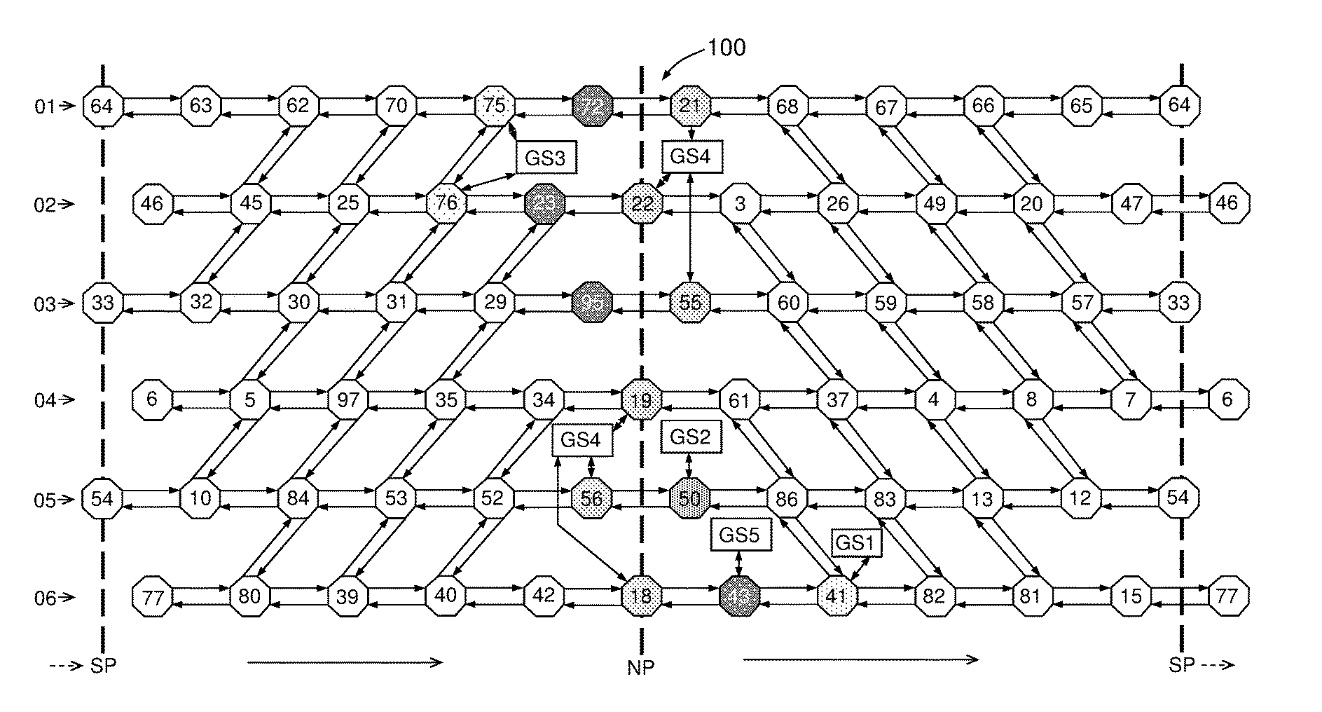
FIG. 1 is a schematic diagram of an example of a satellite communications network;
FIGS. 2 and 3 are schematic diagrams of a portion of a satellite communications network that illustrate techniques for routing a data packet in the satellite communications network;
FIGS. 4a and 4b are schematic diagrams that illustrate traffic levels in a satellite-to-satellite communication link; and
FIG. 5 is a flowchart that illustrates a process of determining a route for routing data in a satellite communications network.
DETAILED DESCRIPTION
In one example, a satellite communication network includes a constellation of satellites (e.g., a constellation of non-geostationary satellites like a constellation of low earth orbit (LEO) (e.g., 160-2,000 km above the Earth's surface) satellites) interconnected by satellite-to-satellite communication links. One example of such a satellite communications network is the current Iridium.RTM. constellation. Another example of such a satellite communications network is the Iridium NEXT constellation currently under development.
FIG. 1 illustrates, schematically, the topology of an example of a satellite network 100 (e.g., a constellation of non-geostationary satellites in LEO). As illustrated in FIG. 1, this network comprises 66 satellites (referenced 3, 4, 5, 6, 8, 7, 10, 12, 13, 15, 18, 19, 20, 21, 22, 23, 25, 26, 29, 30, 31, 32, 33, 34, 35, 37, 39, 40, 41, 42, 43, 45, 46, 47, 49, 50, 52, 53, 54, 55, 56, 57, 58, 59, 60, 61, 62, 63, 64, 65, 66, 67, 68, 70, 72, 75, 76, 77, 80, 81, 82, 83, 84, 86, 95, 97), 11 on each one of 6 orbital planes O1-O6, the orbital planes being spaced approximately 30 degrees apart. As illustrated, the orbits are nearly polar (e.g., the orbits have an inclination of approximately 86.4.degree.) and are substantially circular (e.g., at a height of approximately 781 km above the earth). In some implementations, the orbital period may be about (or on the order of) 100 minutes.
Individual satellites communicate with neighboring satellites via satellite-to-satellite communication links ("cross-links"). As illustrated in FIG. 1, an individual satellite may be cross-linked to four neighboring satellites: two to neighbors fore and aft in the same orbital plane and two to satellites in neighboring planes to either side. In some implementations, the cross-links may be implemented in the K.sub.a frequency band. As illustrated in FIG. 1, in some implementations, near the North Pole NP and the South Pole SP, there may be no cross-links between satellites in adjacent planes. Moreover, although orbital planes O1 and O6 are adjacent, their satellites orbit in opposite directions. Therefore, in some implementations, there may be no cross-links between the satellites in orbital planes O1 and O6.
As illustrated in FIG. 1, the satellite communications network also includes 5 ground stations: GS1 (e.g., situated in Hawaii (USA)), GS2 (e.g., situated at Fairbanks (Alaska, USA)), GS3 (e.g., situated in Tempe (Arizona, USA)), GS4 (e.g., situated in Svalbard (Norway)), and GS5 (e.g., situated in Yellowknife (Northwest Territories, Canada)). At any given time, one or more satellites may be connected to one or more ground stations (e.g., by feeder link(s)). For example, as illustrated in FIG. 1, satellite 41 is connected to GS1, satellite 50 is connected to GS2, satellites 75 and 76 are connected to GS3, satellites 21, 22, 55, 19, 56 and 18 are connected to GS4, and satellites 72, 23, 95 and 43 are connected to GS5. In some implementations, feeder links between satellites and ground stations may be implemented in the K frequency band.
Additional terrestrial terminals (e.g., mobile satellite terminals like satellite telephones and other mobile satellite communications devices) may be used in addition to or in lieu of ground stations, and may establish connections with one or more of the satellites, for example, for the purpose of routing communications from the terrestrial terminals to other terrestrial destinations and/or vice versa via the satellite communications network (and, in some cases, one or more other networks (e.g., the public switched telephone network (PSTN), the Internet, etc.)). In some implementations, such connections between satellites and terrestrial mobile satellite terminals may be implemented in the L frequency band.
FIG. 1 illustrates the network topology at a given point in time. However, the topology changes over time due to the movements of the satellites along their orbits and/or the rotation of the earth. For example, a few minutes after the point in time illustrated in FIG. 1, the cross-link between satellites 20 and 57 may be broken (e.g., as satellites 20 and 57 near the south pole), while a cross-link between satellites 33 and 46 may be established (e.g., as satellites 33 and 46 move away from the south pole), satellite 29 may establish a connection with GS5 (e.g., as satellite 29 nears the north pole and the earth rotates), satellite 43 may break its connection with GS5 and establish a new connection with GS4, and satellite 55 no longer may be connected to a ground station.
As illustrated in FIG. 1, the satellites and ground stations represent nodes of the satellite communications network. Data (e.g., packets), representing e.g. phone calls or other communications, may be routed between satellites and/or one or more ground stations in order for the data to be transmitted from its origin (e.g., a mobile satellite terminal) to its intended destination (e.g., a ground station for routing to a terrestrial terminal via another network like the PSTN or the Internet).
The satellite network 100 may employ various different techniques to handle problems (e.g., failure and/or congestion) with the cross-links between individual satellites. For example, in the event that a satellite detects a problem (e.g., failure or congestion) with a cross-link that it intended to use to transmit data to another satellite, the satellite may use another of its cross-links to transmit the data to a different satellite to enable the data to progress toward its ultimate destination. This technique may be referred to as local rerouting and an example is illustrated in FIG. 2.
As illustrated in FIG. 2, reference R1 identifies a route determined for a packet to traverse to reach satellite 41 from satellite 52. The packet follows route R1 until it reaches satellite 18. However, as illustrated in FIG. 2, satellite 18 has detected that its cross-link with satellite 42 is experiencing a problem (e.g., failure and/or congestion). Therefore, route R1 is interrupted and a new route is determined to route the packet to satellite 41. In particular, satellite 18 redirects the packet along route R2, allowing it to eventually reach its destination of satellite 41. When such local rerouting is performed, to prevent the packet from being routed back to satellite 18, a "no u-turn" function may be implemented. However, this function can be defeated by a failed link (e.g., if the cross-link between satellites 42 and 40 experiences a problem). Furthermore, the local rerouting solution may lead to sub-optimal routing, and, in some cases, even to deadlocks. Moreover, local rerouting may not allow for efficient and/or effective congestion management.
The techniques described herein may mitigate the above-mentioned drawbacks of the local rerouting technique, potentially allowing for more efficient management of problematic cross-links (e.g., failed and/or congested cross-links) in a satellite communications network.
For example, cross-link problems (e.g., failure and/or congestion) in a satellite communications system may be addressed using routing tables that contain full descriptions of multiple routes between different source--destination satellite pairs (e.g., multiple routes between each possible source--destination satellite pair in the satellite communications network) and alert messages transmitted by satellites (or other nodes) experiencing problems (e.g., failure and/or congestion) with at least one of their cross-links.
In some implementations, each satellite receives, from a ground station (either directly or indirectly via one or more other satellites), a routing table that includes complete descriptions of a plurality of different routes linking it to all (or some subset of all of) the other satellites of the network. In other implementations, only some subset of the satellites may receive routing tables that include complete descriptions of pluralities of different routes linking them to all (or some subset of all of) the other satellites of the network. A "complete description" of a route may be, for example, an ordered list of nodes (e.g., satellites) forming the route. The routing table(s) distributed to the satellites may original from a terrestrial operations center.
In some implementations, there may be a hierarchical order between the routes linking a "source" satellite to a "destination" satellite. For example, one route may be designated as the "primary" route and be intended to be used as the default route; meanwhile, other routes may be designated as "backup" routes to be used in the event that one of the satellite-to-satellite links of the primary route experiences a problem (e.g., failure or congestion). Such backup routes also may have a hierarchical ordering defining the order in which they are to be used in the event of problems with cross-links in the different backup routes.
An example is illustrated in FIG. 3. As illustrated in FIG. 3, a primary route PR and three backup routes BR1, BR2 and BR3 have been defined between satellite 52 and 41. The following Table 1 represents a portion of one example of a routing table for satellite 52 that shows examples of descriptions of these different routes linking satellite 52 to satellite 41:
TABLE-US-00001 TABLE 1 Destination satellite Route Description Status 41 PR 40-42-18-43 I BR1 56-50-86 A BR2 34-19-61-86 A BR3 53-39-40-42-18-43 I
As illustrated in Table 1, the routing table for satellite 52 instructs satellite 52 to route a data packet destined for satellite 41 along the primary route PR, extending through satellites 40, 42, 18 and 43, unless there is a problem (e.g., failure and/or congestion) with a cross-link within the primary route PR. Such a problem is illustrated in FIG. 3, where there is a problem (e.g., failure and/or congestion) with the cross-link between satellites 18 and 43. As described in greater detail below, satellite 52 will have received prior notification of this the problem impacting the cross-link between satellites 18 and 43 and, therefore, satellite 52 will choose to route the packet to satellite 41 using the first backup route BR1 instead of the primary route PR. In the event that backup route BR1 also is experiencing a problem with a cross-link, satellite 52 would use BR2 to route the packet to satellite 41 instead and so on.
In some implementations, the routing table for a satellite may include at least two routes for routing data from the satellite to a destination satellite that do not have any (or that have no more than some predefined number of) intermediary satellites in common.
In the example illustrated in Table 1, each route between satellite 52 and 41 is characterized by a "status", which is illustrated in this example as taking one of two values: Inactive (I) (e.g., where one or more of the cross-links in the route are known to be experiencing a problem) or Active (A) (e.g., where none of the cross-links in the route are known to be experiencing a problem); this will be explained in greater detail below. In alternative implementations, the "status" may take one of three values: Active, Inactive (i.e. failed) and Congested. Such an approach may allow the satellites to route data differently depending on whether problems with cross-links are due to failures or congestion.
It should be noted that the routes linking satellite 41, when it is the source node, to satellite 52, when it is the destination node, may be the same as the routes linking satellite 52 to satellite 41 (albeit with satellites encountered in the reverse order) or different, depending on the particular implementation.
In one particular example of a satellite communications network, there are 66 satellites and each one uses a distinct routing table to route data through the satellite communications network, where each routing table comprises N>1 routes for each of the 65 possible destination satellites, plus the ground stations. In an example where N=4 (e.g., where there is a primary route and three backup routes for each source--destination satellite pair), a route comprises on average 10 satellites (which may be more than the actual value), each satellite of the route is represented by a byte, and an additional byte is used to code the state of each route and, for the sake of simplicity, routes having a ground station as their destination are ignored, the set of all of the routing tables for a given topology may be represented in 66.times.65.times.(10+1) bytes, i.e. slightly more than 46 Kbytes.
In some implementations, the routing tables are transmitted to the satellites by the ground station(s), and the status of all of the routes in any given routing table may be set to "Active" by default. Depending upon the implementation, the routing table used by an individual satellite may be updated at each change of the network topology (which, e.g., may be due to the movement of the satellites along their orbits). Each routing table may be applicable during one or more predetermined active periods (e.g., periods during which the routing table corresponds to the current topology of the satellite communications network). In some implementations, several routing tables are uploaded to individual satellites in advance of their active periods, e.g. several days before. In such implementations, the individual satellites may update their active routing tables themselves, and the synchronization of this updating may be achieved automatically. A ground station may upload routing tables to a satellite when the satellite is connected to the ground station, or routing tables may be routed from the ground station to the satellite across the satellite communications network (e.g., using the routing table(s) of the relevant satellite(s) which are active at the time of the upload) if the satellite is not connected to the ground station.
In order to enable individual satellites to make intelligent choices about which routes listed in their routing tables to use to route data to particular destinations, some or all of the satellites are made aware of known problems (e.g., failures and/or congestion) in the satellite communications network. For example, a satellite experiencing a cross-link failure and/or congestion may initiate an alert (e.g., an alert packet) identifying the problem and/or its location which is transmitted to some or all of the other satellites. In some implementations, conventional flooding algorithms may be used to ensure distribution of the alert to all of the satellites via the satellite-to-satellite links. Such techniques may converge quickly due to the moderate size of a typical satellite communications network.
Various different techniques may be employed to detect a problem in the satellite communications network. For example, an individual satellite may have one or more modems and use the modem(s) to detect problems with its cross-links. In such implementations, the modem on a satellite can detect the failure of one of its cross-links by, for example, monitoring its synchronization state. If the modem detects that the cross-link is synchronized, the modem may determine that the cross-link is functional. In contrast, if the modem detects that the cross-link is not synchronized, the modem may determine that the cross-link has failed. Moreover, a satellite can determine that one of its cross-links is congested, for example, by comparing the known capacity of the cross-link to the current traffic on the cross-link. The described techniques for detecting problems (e.g., cross-link failure and/or congestion) in the satellite communications network are non-exhaustive examples. Other techniques may be employed for detecting problems (e.g., cross-link failure and/or congestion) in the satellite communications network.
Referring again to the example illustrated in FIG. 3, when satellite 18 determines or otherwise becomes aware that there is a problem (e.g., failure and/or congestion) with its cross-link to satellite 43, it generates an alert message AM indicating "link 18-43 interrupted" and initiates the distribution of the alert message through the satellite communications network by sending it through its remaining cross-links (in the example considered here, the cross-link with satellite 42 is its only remaining cross-link). As illustrated in FIG. 3, that alert message AM emitted by satellite 18 may reach satellite 42 at time "t", then satellite 40 at time "t+1", satellites 39 and 52 at time "t+2", satellites 34, 53, 56 and 80 at time "t+3" and so on. In some implementations, satellite 43 also may detect the problem with the cross-link and send a similar (or the same) alert message.
When an individual satellite in the satellite communications network receives the alert message AM, it may change the status of all the routes in its active routing table that include the cross-link between satellites 18 and 14 to "Inactive", for example, as illustrated in Table 1.
Other implementations are possible. For instance, each satellite could store a list of problematic (e.g., failed and/or congested) links and use the list to determine, on the fly, the highest-priority active route to a destination when the satellite needs to transmit data to the destination. Additionally or alternatively, in some implementations, when a cross-link is experiencing congestion, already-established, active connections may be allowed to continue to use the congested cross-link, but new connections may be discouraged (or prevented) from using the cross-link by using backup routes that utilize different cross-links instead. Such an approach may allow for a progressive de-congestion of the congested cross-link.
In some implementations, if a problem in the satellite communications network (e.g., the failure of the cross-link between satellites 18 and 43 illustrated in FIG. 3) is resolved, one or more satellites that detect or otherwise become aware of the resolution (e.g., satellites 18 and 43) may distribute "end-of-alert" messages, for example, using the same mechanism(s) used to distribute the original alert message, and satellites that receive such "end-of-alert" messages may change the status of implicated routes from "Inactive" or "Congested" to "Active" (or withdraw the 18-43 link from their list of failed/congested links).
In situations where the problem with a problematic cross-link is congestion, it may be advantageous to implement a mechanism to avoid rapid oscillations between statuses of problematic and non-problematic. For example, a non-congested cross-link may be determined to become congested when the traffic on the cross-link exceeds a first threshold T1 while a congested cross-link may be determined to become non-congested when the traffic on the cross-link decreases below a second threshold T2, where T2<T1.
In some implementations, Quality-of-Service (QoS) levels associated with different types of traffic carried across the satellite communications network may be used in determining how to route different traffic in the satellite communications network, particularly in the case of congestion on one or more cross-links. For example, in one implementation, traffic may be assigned to one of four different QoS levels, QoS1, QoS2, QoS3, and QoS4, where QoS1 traffic is to be given priority over QoS2, QoS3, and QoS4 traffic, QoS2 traffic is to be given priority over QoS3 and QoS4 traffic, and so on. In such implementations, when different QoS level traffic is being considered for routing over a congested cross-link, higher priority QoS level traffic may be routed over the congested cross-link before lower priority QoS level traffic. For example, if the traffic being routed over a cross-link causes the traffic on the cross-link to exceed a threshold level of congestion, the link may be determined to be congested and routed away from the cross-link for the lowest priority QoS level of traffic currently being routed over the cross-link and each successive higher priority QoS level of traffic until the traffic being routed across the cross-link falls below an uncongested traffic level.
FIGS. 4a and 4b illustrate one example. Referring first to FIG. 4a, FIG. 4a illustrates the current traffic load across the 18-43 satellite pair cross-link in a case where four different QoS levels--QoS1 to QoS4--are present. FC represents the free capacity of the link. As illustrated in FIG. 4, the sum of the QoS1 and QoS2 traffic does not exceed the congestion threshold CT, but, when the QoS3 and QoS4 traffic are considered, the traffic across the cross-link exceeds the congestion threshold CT. As a result, one or both of satellites 18 and 43 may determine that the cross-link is congested for QoS3 and QoS4 traffic and transmit an alert message indicating "link 18-43 congested for QoS3 and QoS4" for distribution through the satellite communications network. Consequently, satellites that receive this alert message may consider routes that include the 18-43 satellite pair cross-link to be "Active" for QoS1 and QoS2 traffic but "Inactive" for QoS3 and QoS4 traffic. This may eliminate (or at least reduce) the congestion of the cross-link, for example, as illustrated in FIG. 4b, thereby potentially providing better Quality-of-Service to the higher priority QoS1 and QoS2 traffic than the QoS3 and QoS4 traffic. Alternatively, in some implementations, all QoS4 traffic may be rerouted away from the 18-43 satellite pair cross-link while only a portion of the QoS3 traffic is rerouted.
FIG. 5 is a flowchart that illustrates a process 500 of determining a route for routing data in a satellite communications network (e.g., a satellite communications network that includes multiple satellites that are interconnected by satellite-to-satellite communication links, such as, for example, the example satellite communications networks described above). The process 500 may be performed by a satellite, or a component of a satellite, in the satellite communications network. For example, the satellite, or the component of the satellite, may include one or more logic elements (e.g., one or more processors, field programmable gate arrays (FPGAs), and the like) that are configured to perform the process.
As illustrated in FIG. 5, a data structure (e.g., a routing table) that identifies different possible destinations (e.g., other satellites and/or ground stations) and defines multiple different routes for routing data from the satellite to the destinations is stored (505). For example, the data structure may be stored in a computer-readable storage medium on board the satellite.
At some point, an indication of a problem in the satellite network (e.g., a failure of and/or congestion in a cross-link) is received (510). For example, as described above, another satellite in the satellite communications network may detect a problem and transmit an alert message identifying the problem to other satellites in the satellite communications network. After the indication of the problem has been received, a determination is made that the problem impacts a first one of the routes defined in the data structure for routing data from the satellite to a particular destination (e.g., a particular satellite or ground station) (515). As a consequence of determining that the problem impacts the first route from the satellite to the particular destination, the data structure is updated to reflect that the first route has been impacted by the problem (520). For example, the data structure may be updated to reflect that a failure has occurred in the first route and/or that the first route is congested.
Thereafter, data to be routed from the satellite to the particular destination is received (525). In response to receiving the data to be routed from the satellite to the particular destination, the data structure is accessed and a determination is made that the first route for routing data from the satellite to the particular destination has been impacted by a problem (530). For example, a determination may be made that a failure has occurred in the first route and/or that the first route is congested. As a consequence of having determined that the first route has been impacted by a problem, a second route for routing data from the satellite to the particular destination is selected from the different routes for routing data from the satellite to the destination that are defined in the data structure (535). The data then may be routed (e.g., transmitted) to another satellite according to the selected route.
Aspects of the present disclosure may be implemented entirely in hardware, entirely in software (including firmware, resident software, micro-code, etc.) or in combinations of software and hardware that may all generally be referred to herein as a "module," "component," or "system." Furthermore, aspects of the present disclosure may take the form of a computer program product embodied in one or more computer-readable media having computer-readable program code embodied thereon.
Any combination of one or more computer-readable media may be utilized. The computer-readable media may be a computer-readable signal medium or a computer-readable storage medium. A computer-readable storage medium may be, for example, but not limited to, an electronic, magnetic, optical, electromagnetic, or semiconductor system, apparatus, or device, or any suitable combination of the foregoing. More specific examples (a non-exhaustive list) of such a computer-readable storage medium include the following: a portable computer diskette, a hard disk, a random access memory (RAM), a read-only memory (ROM), an erasable programmable read-only memory (EPROM or Flash memory), an appropriate optical fiber with a repeater, a portable compact disc read-only memory (CD-ROM), an optical storage device, a magnetic storage device, or any suitable combination of the foregoing. In the context of this document, a computer-readable storage medium may be any tangible medium that can contain, or store a program for use by or in connection with an instruction execution system, apparatus, or device.
A computer-readable signal medium may include a propagated data signal with computer-readable program code embodied therein, for example, in baseband or as part of a carrier wave. Such a propagated signal may take any of a variety of forms, including, but not limited to, electro-magnetic, optical, or any suitable combination thereof. A computer-readable signal medium may be any computer-readable medium that is not a computer-readable storage medium and that can communicate, propagate, or transport a program for use by or in connection with an instruction execution system, apparatus, or device. Program code embodied on a computer-readable signal medium may be transmitted using any appropriate medium, including but not limited to wireless, wireline, optical fiber cable, RF signals, etc., or any suitable combination of the foregoing.
Computer program code for carrying out operations for aspects of the present disclosure may be written in any combination of one or more programming languages, including object oriented programming languages, dynamic programming languages, and/or procedural programming languages.
The figures illustrate examples of possible implementations according to various aspects of the present disclosure. In this regard, each block in a flowchart may represent a module, segment, or portion of code, which comprises one or more executable instructions for implementing the specified logical function(s). It should also be noted that, in some alternative implementations, the functions noted in the block may occur out of the order illustrated in a figure. For example, two blocks shown in succession may, in fact, be executed substantially concurrently, or the blocks may sometimes be executed in the reverse order, depending upon the functionality involved. It will also be noted that each block of a flowchart, and combinations of blocks in a flowchart, can be implemented by special purpose hardware-based systems that perform the specified functions or acts, or combinations of special purpose hardware and computer instructions.
The description of the present disclosure has been presented for purposes of illustration and description, but is not intended to be exhaustive or limited to the disclosure in the form disclosed. Other implementations are possible. For instance, alert messages transmitted from at least some of the satellites can also be transmitted to one or more ground stations. Moreover, the ground stations can also detect problems and/or the resolution of problems in the satellite communications network and transmit alert and/or end-of-alert messages to other ground stations and/or to satellites in response. After all, both the satellites and the ground stations may be considered nodes of the satellite communications network and may be capable of performing some of the same functions, particularly when it comes to making decisions about how to route data in the satellite communications network.
* * * * *
D00000
D00001
D00002
D00003
XML
uspto.report is an independent third-party trademark research tool that is not affiliated, endorsed, or sponsored by the United States Patent and Trademark Office (USPTO) or any other governmental organization. The information provided by uspto.report is based on publicly available data at the time of writing and is intended for informational purposes only.
While we strive to provide accurate and up-to-date information, we do not guarantee the accuracy, completeness, reliability, or suitability of the information displayed on this site. The use of this site is at your own risk. Any reliance you place on such information is therefore strictly at your own risk.
All official trademark data, including owner information, should be verified by visiting the official USPTO website at www.uspto.gov. This site is not intended to replace professional legal advice and should not be used as a substitute for consulting with a legal professional who is knowledgeable about trademark law.